![]()
Prev Page--Introduction, Stratigraphic Framework || Next Page--Depositional Environments
Description of Longford Member, Kiowa Formation
Name, Type Section, Distribution, and Thickness
The Longford Member of the Kiowa Formation crops out in two separated areas in north-central Kansas (Fig. 1). The northern area spans parts of Clay, Ottawa, Saline, and northwestern Dickinson counties. The southern area includes parts of western Marion County and small parts of eastern McPherson and southwestern Dickinson counties. Longford rocks were not found in large parts of Saline, McPherson, and Rice counties. The member is named for exposures in the northern area of outcrops, those north of the town of Longford, southwestern Clay County (Pl. 1). The type section (measured section 1, Appendix B and Pls. 1, 2) was described in drainage cutbanks in W2 SW sec. 9, T. 10 S., R. 1 E., and in roadcuts along the road linking Longford to Oak Hill on the west line SW sec. 9. The contact with overlying Kiowa rocks is not exposed in the immediate vicinity of Longford, but it is well exposed in sec. 32, T. 9 S., R. 1 E., Clay County (measured section 2, Appendix B and Pls. 1, 2). A reference section was described near the cen. SE sec. 23, T. 16 S., R. 1 E., Dickinson County, in the southern area of outcrops where other aspects of the member are expressed (measured section 3, Appendix B, Fig. 1 and Pl. 2). Excellent exposures of the member can be seen in sec. 27, T. 9 S., R. 1 E., near the NE corner sec. 1, T. 6 S., R. 1 E., and near the center sec. 1, T. 6 S., R. 2 E., Clay County (Pl. 1).
The Longford Member ranges in thickness from 0 to about 100 ft (0 to 30 m). Maximum thickness is near Longford and Oak Hill, southwestern Clay County (Pl. 1). The member grades westward into, and intertongues with, more characteristic Kiowa rocks. Longford rocks are facies equivalents of rocks in the upper parts of the Inoceramus comancheanus and the lower parts of the I. bellvuensis concurrent range zones of Scott (1970b) (Fig. 2). The member thins northward and could not be distinguished in any practical way from basal Dakota rocks north of secs. 33 and 34, T. 5 S., R. 3 E., Washington County, along the pinchout of the Kiowa Formation (Fig. 2; Pl. 1). The northward thinning and disappearance of the Kiowa Formation and its Longford Member beneath the Dakota Formation in Clay and Washington counties shows some coincidence with the northward increase in breadth of the gently dipping western limb of the Nemaha anticline (Fig. 1) in north-central Kansas (cf. Merriam, 1963, Fig. 100). In outcrop, the siltstone marking the top of the Longford Member is the northernmost kind of Kiowa rock that can be identified with certainty beneath the Dakota Formation in north-central Kansas.
The distribution of Longford rocks in the subsurface west of the outcrop areas is incompletely known. The member extends beneath large parts of Ottawa County and apparently reaches into the subsurface of northwestern Ellsworth County (Fig. 1) (O. S. Fent, 1977, written communication). The stratigraphic relations between Longford rocks and the sequences of nearly white to greenish-gray siltstone, shale, and sandstone in the subsurface north of the type area of the Cheyenne and Kiowa formations and in western Rice County (Fent, 1950; Latta, 1950; McLaughlin, 1949) are problematic, inasmuch as neither Longford rocks nor those rocks are present at the base of the Kiowa Formation on the outcrop in eastern Rice County or in most of McPherson County (Fie,. 1). Despite the pinchout of the Kiowa Formation along the Nemaha anticline in north-central Kansas, Longford rocks, or their analogues, may extend into the subsurface of southern and central Nebraska, as is suggested by the depositional strike inferred for the Kiowa Formation (about N 25° W) (Fig. 1) and by the distribution of rock types within the member. As is true in outcrop, tracing the Longford Member in the subsurface will depend largely on being able to recognize the siltstone that marks the top of the member.
Siltstone at Top of Longford Member
The siltstone that marks the top of the Longford Member (Pl. 2; Figs. 4, 5) is a distinctive unit that allows ready differentiation between Longford rocks and the shale and sandstone in higher and laterally equivalent parts of the Kiowa Formation. The siltstone also is a useful stratigraphic reference where the Dakota Formation rests on the Longford Member. The capping siltstone generally is between 3 and 15 ft (0.9 and 4.6 m) thick. Characteristically it is nearly white, but commonly it is light gray or stained light brownish gray, light yellowish gray, or grayish orange by "limonite." In most places, it is well indurated and weathers to thin beds that in turn are composed of thin laminae. The laminae are uniform and horizontal, or wavy, or rippled. Ripple marks include diversely oriented, symmetric and asymmetric transverse forms having amplitudes of 1 to 3 cm and wavelengths between 3 and 15 cm. Locally, interference patterns are seen. Also present are diversely oriented linguoid ripples as much as 15 cm across. In places, small-scale cross-laminae (including the micro-cross-lamination of Hamblin, 1961, or rib-and-furrow structure of Stokes, 1953) are common. Locally, flaser bedding can be detected in the siltstone. In a few places, even or wavy and ripple-marked laminae form sets of gently inclined cross-strata that depart less than 10 degrees from the horizontal (Fig. 5). Locally, the sets of cross-strata truncate underlying horizontal stratification.
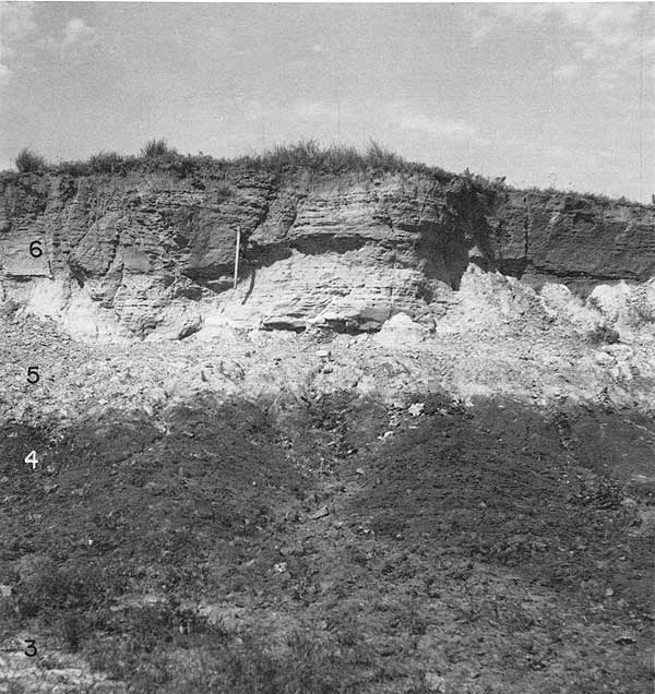
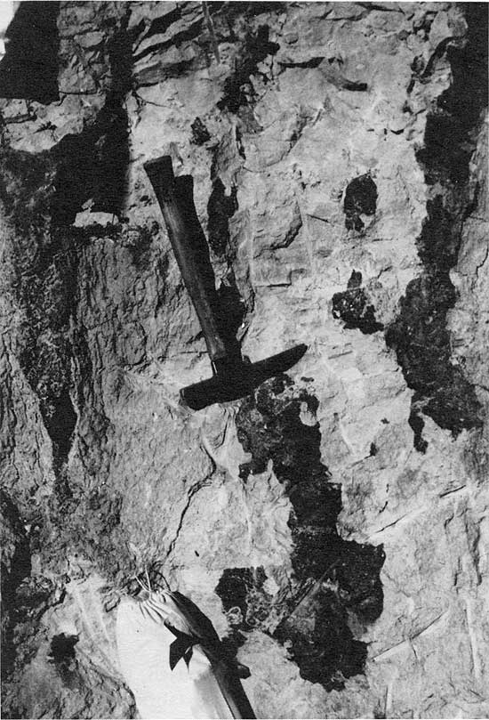
Figure 4--Thin-bedded to thin-laminated siltstone marking top of Longford Member near type Longford, about 0.15 mi (0.24 km) north of SE corner sec. 8, T. 10 S., R. 1 E., Clay County. Road cut, not actually part of measured section 1 (Appendix B and Pl. 2), almost spans the interval from unit 17 through unit 19 in the measured section. Note dark, discoidal masses of calcite-cemented siltstone at top of exposure. Handle of pick about 2.5 ft (0.8 m) long.
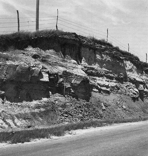
Figure 5--Thin-bedded to thin-laminated siltstone marking top of Longford Member, SE sec. 23, T. 16 S., R. 1 E., Dickinson County. Siltstone grades downward into dark-gray, plastic claystone in middle ground. Note low-angle cross-strata most evident above and to left of top of pick. Handle of pick about 2.5 ft (0.8 m) long. Numbers refer to units in measured section 3 (Appendix B and Pl. 2).
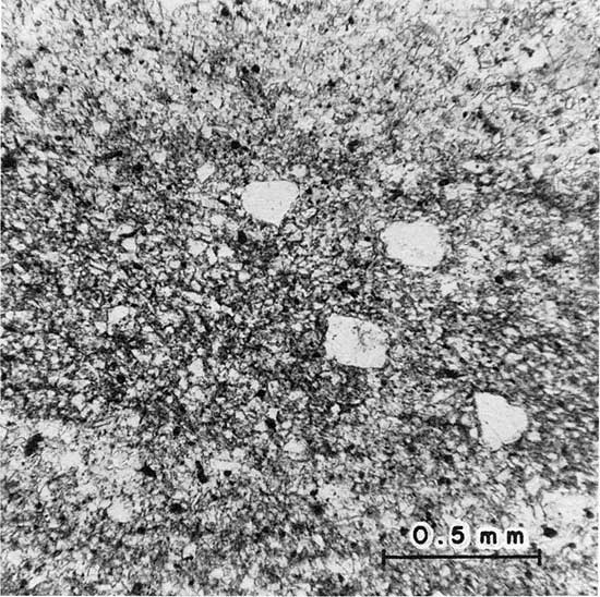
Well-sorted, subangular to subrounded quartz grains, chiefly medium to coarse silt, approximate 95 percent of the capping siltstone. The rock commonly contains disseminated, rounded to subangular quartz grains that measure as much as 0.2 mm in long diameter and show nearly straight extinction. Generally, the sand-sized grains amount to less than one percent of the rock, but, locally, where they are concentrated, they impart a striking bimodal grain-size distribution to parts of the rock (Fig. 6). One percent or less heavy minerals, chiefly zircon and tourmaline, are present. Sparse nodules of marcasite or pyrite locally enclose scattered fragments of carbonaceous matter. Except for trace amounts of detrital muscovite, interstitial clay makes up most of the remainder of the rock. Where the rock is friable, it is nearly devoid of interstitial clay. Calcite cement is distributed erratically through indurated parts of the siltstone. The cement locally follows bedding, but it also forms discoidal to spherical concretionary masses (Fig. 4). The indurated siltstone tends to form ledges and benches that stand out in relief along gentle slopes developed on overlying Kiowa shale and on underlying Longford clay rocks.
Figure 6--Photomicrograph of siltstone in upper part of Longford Member, center W line SW sec. 9, T. 10 S., R. 1 E., Clay County (unit 13, measured section 1, Appendix B and Pi. 2). Carbonaceous lamina (dark gray) contains subrounded quartz grains as much as 0.2 mm in long diameter. The rock also contains appreciable interstitial clay. Plane-polarized light.
The drilling characteristics of the siltstone at the top of the Longford Member are distinctive and should be helpful in tracing the subsurface distribution of the member even though the rock yields few cuttings when penetrated by a roller bit (O. S. Fent, 1977, written communication). Rather, the rock responds much like a friable, fine-grained sandstone, and the samples contain only sparse chips of indurated, white to light-green siltstone. Decanting the mud fails to reveal sand grains.
Plant material and molds and casts of burrows or trails were the only fossils seen in the siltstone. The plant material occurs chiefly as macerated stem or leaf debris scattered along bedding surfaces, either as carbonized fragments or as imprints. In southern Ottawa County and nearby parts of Saline County (Fig. 1), however, the lower and middle parts of the siltstone locally contain tubular molds and casts resembling features that Hattin (1965) and Siemers (1971) identified as fossil reeds near the top of the Dakota Formation in central Kansas. C. T. Siemers (1976, written communication), however, suggested that some of the Longford structures may be insect burrows, whereas others indeed are reed fossils. The structures in the Longford Member are as much as 38 cm long and 3 mm in diameter. Their orientation is upright or departs less than 15 degrees from the normal to bedding. The fossils occur as molds on weathered surfaces, and as silt- and clay-filled casts. In places, carbonaceous matter outlines or is entrapped in the casts. Some of the casts contain iron sulfide or "limonite," and some are surrounded by iron-oxide oxidation haloes that are as much as 6 cm in diameter. Bedding is not disturbed by the structures, nor is it apparent in them.
Molds and casts of branching stems or rootlets are preserved in the capping siltstone in parts of Dickinson County where the base of the siltstone is within a few feet of lignite in the lower parts of the member. The walls of the structures are smooth, relatively straight to arcuate, and branching. The structures are 2 mm or less in diameter, but they are as much as 7 cm long. The molds and their silty casts tend to follow bedding, but they also penetrate it at steep angles. Trace fossils that may be insect trails (Siemers, 1976, written communication) commonly are associated with the fossil stems or rootlets. They are smooth-walled to beaded, gently arcuate bedding-plane casts that are 1 to 2 mm in diameter and as much as 5 cm long.
Other trace fossils in the capping siltstone include burrows of uncertain affinities. One is a Planolites-like structure (Häntzschel, 1962; Frey and Howard, 1970) that consists of circular molds and casts that both transect and tend to follow the wavy bedding of the rock. The molds and their siltstone casts are about 1 cm in diameter and as much as 10 cm long. A second type of burrow is tubular and subvertical. Some are rod-shaped; others are Y-shaped. They measure from 0.2 to 1.5 cm in diameter and are as much as 20 cm long, although most are less than 15 cm long. Most of the structures are smooth walled and resemble the various rod-shaped and tubular burrows described by Frey and Howard (1970) and Siemers (1971). Some, however, have a segmented appearance similar to that of Arthrophycus (Frey and Howard, 1970), but the segmentation may be an artifact of bedding.
An upward progression of trace fossils and sedimentary structures can be deciphered locally in southwestern Dickinson County (Fig. 1). Wavy laminated strata containing molds and casts of branching stems or rootlets, as well as insect trails, occur low in the capping siltstone in places. Elsewhere, the lower parts of the unit show only even, horizontal laminae along which carbonaceous plant debris is scattered. In the middle and upper parts of the siltstone, rod- and Y-shaped burrows occur widely and are associated with current and oscillation ripple marks.
The contact between the siltstone and overlying Kiowa shale is gradational (measured sections 2 and 3, Appendix B and Pl. 2). The basal few centimeters or tens of centimeters of shale above the Longford Member commonly are light to dark gray, smectitic and kaolinitic, and silty. Discontinuous laminae of clay-rich siltstone decrease in abundance upward in the interval, and the silty interval grades upward to more typical, plastic, fissile, olive-gray Kiowa shale containing discoidal concretions of impure siderite (clay ironstone) that are strung out along bedding planes. In many places, the siltstone that marks the top of the Longford Member is separated from typical Kiowa shale by as much as 6 ft (2 m) of plastic, light-gray shale having poor fissility. The shale is composed of variable proportions of smectite, kaolinite, and illitic clay. The clay-mineral assemblage is intermediate between that of typical Kiowa shale and that of Longford rocks. The shale commonly is silty and much of it contains numerous nodules of marcasite or pyrite as well as variable amounts of carbonaceous matter. Weathered slopes developed on intervals of pyritic shale yield gypsum "sunbursts" and show abundant "limonite" stain. In some parts of southeastern Ottawa County and northern Saline County, the capping siltstone is absent and Kiowa shale rests directly on clay rocks belonging to the lower parts of the member.
Thick, lenticular deposits of fine- to medium-grained Kiowa sandstone, rather than typical, olive-gray Kiowa shale, also rest on the light-gray silty shale described above. In a few places in northwestern Dickinson County and western Clay County (e.g., due south and due west of Longford), thick, lenticular deposits of Kiowa sandstone may rest directly on the siltstone at the top of the Longford Member, but poor exposures of the lower parts of the sandstone lenses prevent direct observation of the contacts.
Where the upper parts of the Kiowa Formation are truncated by the Dakota Formation in Clay and Washington counties (Pl. 1), Dakota rocks rest unconformably on the Longford Member (Fig. 2). Nonetheless, the capping siltstone still allows recognition of the top of the Longford Member in many places, even though the lowermost parts of the Dakota Formation contain appreciable silt, much of it apparently reworked from Longford rocks. However, where pre-Dakota erosion removed the siltstone that marks the top of the member, separation of Longford rocks from the overlying Dakota Formation generally is impractical owing to the similarity of the clay rocks in the two units.
The boundary between the siltstone at the top of Longford Member and the argillaceous rocks that form the bulk of the underlying parts of the member is gradational in most places. The siltstone becomes enriched in clay near the boundary; the clay rocks become laminated in their upper parts; and laminae and beds of siltstone become more abundant upward. The transition commonly takes place in a stratigraphic interval that is 3 to 6 ft (1 to 2 m) thick (measured section 3, Appendix B and Pl. 2). Elsewhere, sequences of poorly indurated siltstone, or siltstone showing little sign of bedding, intervene between the clay rocks and the capping siltstone (measured section 1, Appendix B and Pl. 2).
Lower Part of Longford Member
The assemblage of Longford rocks beneath the capping siltstone is highly varied, both in lithology and thickness. Local variations in thickness are controlled chiefly by relief along the Permian-Cretaceous unconformity, but regional variations in thickness also occur. Greatest thickness, as much as 80 ft (24 m), is in western Clay County in the vicinity of Longford and Oak Hill (Plate 1). The rocks thin southward and westward from there, and, in parts of Marion County, the capping siltstone appears to rest directly on weathered Permian strata.
Longford rocks beneath the capping siltstone mostly are clay rocks and siltstone, but sparse layers of lignite and beds and lenses of sandstone also are present. Light-gray clay rocks blotched by abundant red, hematitic mottles are found chiefly in the northern parts of the Longford outcrop belt (Clay and Ottawa counties, Fig. 1), whereas gray clay rocks and carbonaceous beds are most abundant in the southern parts of the outcrop belt (Dickinson and Marion counties, Fig. 1). The scattered exposures of the lower parts of the member in eastern Ottawa County and north-central Saline County, southwestward from the type area, also suggest an analogous westward decrease in the abundance of red-mottled clay rocks, and an increase in the abundance of gray clay rocks and carbonaceous materials. Most of the sandstone exposed in the lower parts of the member is in the northern parts of the outcrop belt, chiefly in Clay County.
Clay rocks and carbonaceous beds
The clay rocks in the lower part of the Longford Member range from dark-gray and brownish-black, plastic claystone and thin-laminated, brownish-gray, carbonaceous shale to light-gray, light brownish-gray, and red-mottled mudstone (Figs. 5, 7; measured sections 1 and 3, Appendix B). Some of the mudstone grades imperceptibly into siltstone. In places, where the lower parts of the member are relatively silty in Saline, Ottawa, and Clay counties (Fig. 1), the rocks enclose lenses or tongues of fissile gray to olive-gray shale that locally contains concretions of impure siderite (clay ironstone) and is typical of other parts of the Kiowa Formation. Some of the dark clay rocks and brownish-gray carbonaceous shale enclose or grade laterally into beds of lignite, especially in southwestern Dickinson County and northwestern Marion County (Fig. 1).
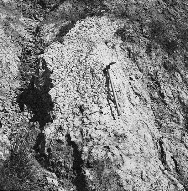
Figure 7--Red-mottled mudstone near base of Longford Member, near cen. W line SW sec. 9, T. 10 S., R. 1 E., Clay County (unit 5, measured section 1, Appendix B and Plate 2). Hematite in the mottles (medium gray near head of pick) has been redistributed by weathering. Puffy and cracked nature of slope indicates the smectitic nature of the rock. Handle of pick about 2.5 ft (0.8 m) long.
The clay rocks form discontinuous beds and lenses generally less than 10 ft (3 m) thick. The writer suspects that no single bed or lens can be traced laterally for more than a few hundred feet (about 100 m). The beds and lenses mostly show gradational or sharply gradational contacts with overlying and underlying units (measured sections 1 and 3, Appendix B and Pl. 2; Figs. 5, 7). Some of the dark-gray and brownish-gray clay rocks that contain abundant carbonaceous matter are thinly laminated and fissile, but bedding within most of the clay rocks is poorly developed and indistinct. In some clay rocks, indistinct bedding is evident on thickness scales of one or more feet (0.3 m or more) because of variations in the amount of silt that the rocks contain. As the proportion of silt in some of the massive mudstones increases, however, the rocks may show indistinct lamination and thin bedding similar to that developed in the capping siltstone. In some red-mottled clay rocks, indistinct layering is imparted by vertical variations in the size and abundance of the red mottles.
Abundant small-scale, randomly oriented, slickensided fractures characterize much of the massive claystone and mudstone. On weathering, the massive clay rocks break into angular and conchoidal chips measuring about 1 cm in long dimension. As weathering continues, however, clay rocks containing appreciable smectite develop puffy, nonresistant slopes much broken by shrinkage cracks (Fig. 7). The puffy slopes developed on Longford clay rocks set them apart from the more resistant slopes formed on kaolinitic, but otherwise similar, rocks in the Dakota Formation.
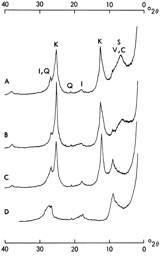
X-ray diffraction studies show that Longford clay rocks contain mainly kaolinite and smectite in the fraction finer than 2 µ (Fig. 8). Illite tends to be a minor component, except in the lenses or tongues of more typical Kiowa shale enclosed by the member. Vermiculite or chlorite occurs widely in Longford clay rocks, but generally in amounts that barely exceed the limits of detection by diffraction methods, primarily as mixed-layer structures with smectite (Fig. 8). No consistent relation was found between the clay minerals in the rocks and their color: gray and dark-gray clay rocks can be as kaolinitic or as smectitic as red-mottled or light-gray rocks, although red-mottled clay rocks tend to be more kaolinitic than the others (Pl. 2). Clay rocks rich in smectite tend to occur near the base of the member (measured section 1, Pl. 2), but exceptions are manifold (measured section 3, Pl. 2). Variations in the proportions of kaolinite and smectite may depend partly on the proportions of silt in the clay rocks, or on the siltiness of the enclosing rocks (units 10 and 15, measured section 1, Pl. 2). Detectable chloritic or vermiculitic components, however, are most common in the lower parts of the member. In contrast, chloritic or vermiculitic clay minerals were not detected either in overlying and facies-equivalent Kiowa rocks or in the bulk of the Dakota Formation in north-central Kansas (Franks, 1966).
Figure 8--Diffractometer patterns of fraction finer than 2 µ from mudstone at base of Longford Member, Kiowa Formation, SE SW SW sec. 9, T. 10 S., R. 1 E., Clay County (near measured section 1, Appendix B and Pl. 2). Scale-factor setting 8, time-constant setting 4, nickel-filtered copper radiation. A) air-dried; B) glycerated; C) heated to 450° C; D) heated at 575° C for one-half hour. Pattern A shows abundant kaolinite (K), lesser amounts of illite (I), and small amounts of quartz (Q). Smectite or mixed-layer peak near 6.4°2Θ (13.8A) (S, V, C) shows sign of a possible "superlattice" diffraction near 2.8°2Θ (31 or 32A). In pattern B, smectite or mixed-layer diffraction shows only partial expansion toward 18A and is centered near 5.2°2Θ (17.4A). Pattern C shows incomplete collapse of 13.8-A peak toward 10A and consequent skewing of illite 001 maximum past 6.5°2Θ. Pattern D shows little change in the skewed 10-A diffraction. The presence of small amounts of vermiculite or chlorite interlayered with smectite can be inferred.
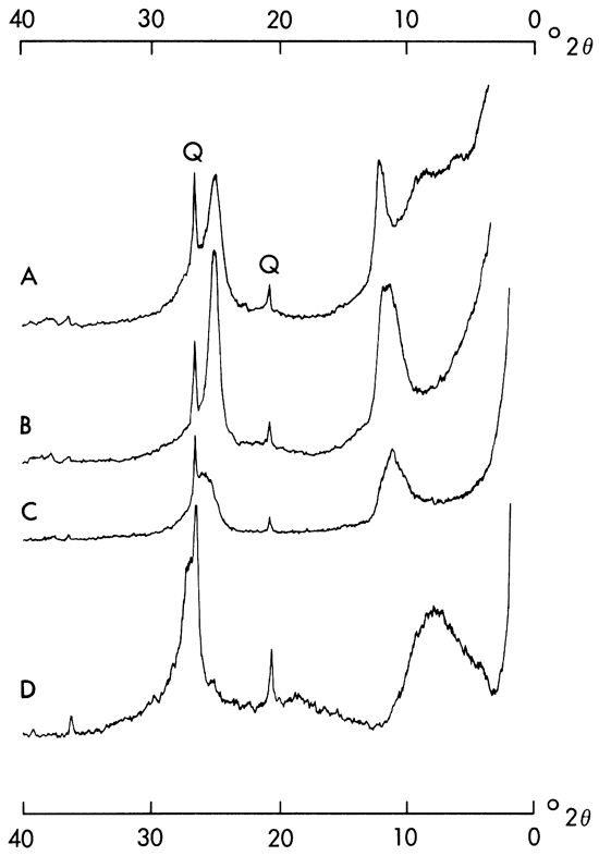
A kaolinite-smectite mixed-layer clay was found in Longford rocks just above the Permian-Cretaceous unconformity in southwestern Dickinson County. X-ray diffraction traces of the mixed-layer clay are shown in Figure 9. The clay is of particular interest because of the apparent scarcity of interstratified kaolinite-smectite complexes in the rock record (Schultz and others, 1971; Wiewiora, 1971). The mixed-layer clay occurs near the base of the brownish-gray and red-mottled clay rocks of unit 3, measured section 3 (Appendix B and Pl. 2), where numerous fragments and pods of claystone reworked from underlying-Permian rocks also are present (Fig. 3). The upper parts of unit 3 contain abundant smectite and lesser amounts of kaolinite, but they lack major amounts of the kaolinite-smectite mixed-layer clay.
Figure 9--Diffractometer traces (nickel-filtered copper radiation) of fraction finer than 2 µ, from mixed-layer kaolinite-smectite clay, base of Longford Member, Kiowa Formation, SE sec. 23, T. 16 S., R. 1 E., Dickinson County (unit 3, measured section 3, Appendix B and Pl. 2). A) air-dried, scale-factor setting 4, time-constant setting 4; B) glycerated, scale-factor setting 4, time-constant setting 4; C) heated to 450° C, scale-factor setting 8, time-constant setting 4; D) heated at 575° C for one-half hour, scale-factor setting 2, time-constant setting 8. Pattern A shows prominent quartz peaks (Q) and prominent, broad diffractions at 12.2° and 25.1°2Θ (7.25 and 3.54A). Diffraction at 12.2°2Θ is sharply skewed to 11.3°2Θ (7.8A) and mixed-layer maxima are centered near 6° and 8.5°2Θ (14.7 and 10.4A). Patterns run using 1/4° slits (not figured) reveal a "superlattice" diffraction centered near 3.6°2Θ (24 to 25A). In pattern B, an inflection point may show near 5.2°2Θ; peak at 25.1°2Θ is sharpened; peak at 12.2°2Θ is broadened, has a distinct shoulder at 12.0°2Θ, has a maximum at 11.2°2Θ (7.4 to 7.9A), and is sharply skewed to 9.6°2Θ. Patterns run using 1/4° slits (not figured) show broad "superlattice" maxima centered near 1.7° to 1.8°2Θ (about 50A) and near 2.5°2Θ (25A). They also verified the presence of an inflection point near 5.2°2Θ (17A). The strength of the peaks at 12.2° and 25.1°2Θ in pattern A, combined with the loss of intensity and low-angle shift of the major diffractions in patterns C and D, indicate that kaolinite is a major component in the clay. Kaolinite may also be present as a discrete mineral species. Low-angle shift of the "superlattice" maxima on glyceration indicates the presence of an expansible component, probably smectite, as does the inflection point at 17A. Shifting of the peaks on heating can be explained both by destruction of kaolinite and by collapse of the expansible component to a 10-A spacing.
The red-mottled clay rocks in the lower parts of the Longford Member offer a striking contrast to the generally drab or gray shale of the Kiowa Formation. Where the red-mottled clay rocks contain abundant kaolinite and little smectite, however, they closely resemble red-mottled clay rocks in the Dakota Formation. The red mottles in Longford clay rocks are produced by irregularly shaped concentrations of red, purplish-red, and reddish-brown hematite that stand out against the pale-gray or pale greenish-gray tones of the remainder of the rock (Fig. 7). Some of the hematite is present as stain that permeates the clay matrix of the rocks to form isolated, irregularly shaped patches measuring 1 or 2 cm across; some hematite has a reticulate pattern and fills minute, randomly oriented cracks; and some coats the surfaces of diversely oriented, small-scale, slickensided fractures. The patches, fracture fillings, and fracture coatings coalesce to produce irregularly shaped mottles as much as 10 cm long. In places, the mottles in turn coalesce to produce irregularly shaped vertical streaks as much as 2 ft (0.6 m) long. Red mottles also occur in dark-gray and brownish-gray clay rocks, but the mottles tend to be less prominent and less abundant than they are in the light-colored clay rocks. Holocene weathering has redistributed the hematite in the mottles so that the surfaces of some exposures are stained and streaked grayish-red and red, as are joints and shrinkage cracks.
The pale-gray and light greenish-gray interareas between the red mottles in Longford clay rocks are composed of the same clay minerals that are present in the mottles. In some exposures, the interareas also contain trace amounts of disseminated flecks of carbonaceous matter that was not detected in the mottles. Blebs of marcasite or pyrite localized by the carbonaceous matter were seen in some exposures. Spherules of siderite, generally measuring less than 1 mm in diameter, are common in both the red mottles and the interareas between them in Dakota clay rocks (Plummer and Romary, 1942; Franks, 1966), but siderite spherules were noted in only one exposure of red-mottled Longford mudstone (NE NW sec. 17, T. 6 S., R. 2 E., Clay County).
Thin sections reveal that the red-mottled clay rocks contain variable amounts of silt-sized quartz grains; sparse, partly altered, silt-sized grains of feldspar (less than 2 percent of the silt fraction); scarce, sand-sized quartz grains; and comminuted mica flakes embedded in a clay matrix. The red-mottled mudstone pictured in Figure 10 shows domain and plexoidal clay fabrics that are characteristic of massive clay rocks, but it lacks the relatively uniform orientation of clay flakes and aggregates parallel to bedding that is shown by many shaly rocks. The domain and plexoidal fabrics are produced by variously oriented, birefringent streaks and patches that are composed of aggregated clay and comminuted mica flakes having similar optical orientation. The birefringent streaks and patches measure as much as 0.3 mm long. They enclose areas measuring as much as 0.2 mm across that are composed of smaller, irregularly oriented clay domains that impart a flecked appearance to the thin section (Fig. 10-B, -C). Elongate domains of optically continuous clay locally form linear to arcuate, birefringent streaks as much as 3 mm long and 0.05 mm wide. Some of these streaks have concentrations of hematite stain extending along their central parts (Fig. 10-C). They appear to be oriented aggregates of clay that formed along slickensided fractures seen in hand samples of the rock. In addition, domains of oriented clay partly envelop and form "clay skins" around some of the detrital quartz grains (Fig. 11).
Figure 10--Photomicrographs (crossed polarizers) of thin section of red-mottled Longford mudstone, SW NW sec. 4, T. 12 S., R. 1 W., Ottawa County. X-ray diffraction studies show that the clay fraction is composed largely of kaolinite, but contains appreciable illite, sparse smectite, and detectable chlorite or vermiculite. Some irregularly shaped black areas are concentrations of hematite (H) sieved by silt grains and comminuted mica flakes; other black areas are silt particles at extinction. Angular to subrounded silt-sized quartz (mainly light gray and white) abounds. A) Domain fabric imparted by streak-like aggregates (light gray to white) of optically oriented clay and comminuted mica extends from lower right to upper left; a second, less pronounced domain of preferred orientation is at right angles to that trend. Streaks of oriented clay following both trends locally coincide with margins of coarse silt grains. B) Plexoidal fabric imparted by birefringent streaks of oriented clay trending from lower right to upper left and from lower left to upper right, nearly at right angles. Except for silt particles, areas between intersecting streaks are composed largely of irregularly oriented, smaller clay aggregates that impart speckled appearance to photograph. Arrow indicates silt grain enlarged in Figure 11. C) Linear, oriented clay aggregate bounding fracture extends from left to right. Film of hematite (H with arrow, black along center line of streak) marks the fracture. Note flecked appearance of photograph imparted by irregularly oriented, minute domains of clay away from fracture-controlled birefringent streak.
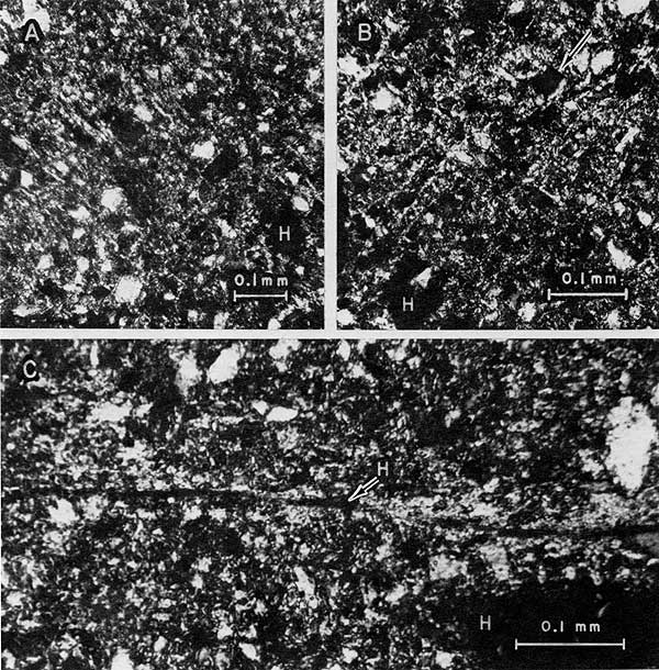
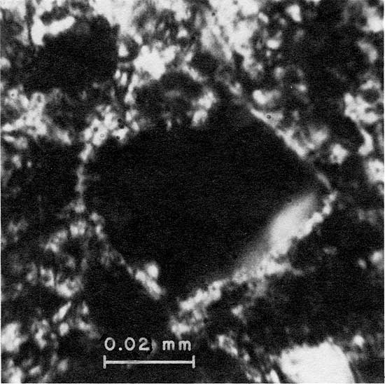
Figure 11--Enlargement (crossed polarizers) of silt grain indicated by arrow in Figure 10-B. Oriented aggregate of clay (light gray to white) forms thin "clay skin" that nearly envelopes grain. Oriented clay along upper and lower right, nearly straight margins of grain contributes to the plexoidal fabric apparent in Figure 10-B.
The clay-rock textures noted above are similar to those produced by flocculation of clays (Meade, 1964), but they also have much in common with fabrics developed in soils (Brewer, 1964). Table 2 is a reconsideration of the fabrics in light of the terminology developed by Brewer (1964). Table 2 is offered, not for the sake of the terminology itself, but because of the importance attached to clay fabrics in the microscopic examination of soils, as opposed to the lack of importance attached to the subject in sedimentary petrology. Evaluation of the fabrics using terminology from soil science, however, necessitates the proviso that similar fabrics may be produced by different processes, and that soil-like fabrics in sedimentary rocks may or may not indicate the operation of soil-forming processes in the genesis of the rocks (Teruggi and Andreis, 1971). Nonetheless, thin-section studies suggest that most massive clay rocks in the Longford Member, red-mottled or not, show fabrics similar to those described above and in Table 2.
Table 2--Clay fabrics in red-mottled Longford mudstone, SW NW sec. 4, T. 12 S., R. 1 W., Ottawa County, and soil-matrix ("s-matrix") and void-fabric terminology of Brewer (1964).
| Microfabrics | Brewer's Terminology1 |
|---|---|
| Irregularly oriented, small-scale, birefringent aggregates of clay that impart a flecked appearance to thin sections at high magnifications (80 to 40OX). Fig. 10-B, 10-C. | Asepic fabric, p. 309 |
| Birefringent aggregates of clay showing preferred orientation, commonly as streaky or linear domains, or sets of domains, that delimit or enclose other regions of smaller, irregularly oriented clay aggregates (asepic regions). Fig. 10-A. | Masepic fabric, p. 313. |
| Birefringent aggregates of clay as above, but as two or more sets of linear or streak-like domains intersecting at various angles, and enclosing regions of smaller, irregularly oriented aggregates (asepic regions). Fig. 10-B. | Bimasepic (trimasepic, etc.) fabric, p. 313. |
| Optically oriented clay aggregates along the margins of silt or sand grains, but forming part of linear or streak-like domains that extend through clay-rich parts of the rock. Fig. 10-A, 10-B. | Skelsepic fabric (neostrians), p. 104, 294. |
| Linear, optically oriented aggregates of clay along variously oriented fractures. | Skew-plane cutans or skew-plane argillans, p. 210. |
| As above, but marked by accumulations of iron oxide. Fig. 10-C. | Skew-plane ferriargillan, p. 210. |
| Optically oriented, thin aggregates of clay enveloping grains of silt or sand ("clay skins"). Fig. 11. | Grain cutans or grain argillans, p. 209. |
| 1Soil materials finer than 30 microns are referred to as "plasma." Aggregates of oriented particles are termed "plasma separations." Hence, the use of the suffixes "sepic" and "masepic" in many of Brewer's coined terms. | |
The amount of carbonaceous matter in Longford clay rocks ranges widely. Light-gray and red-mottled clay rocks contain either no carbonaceous matter or only sparse disseminated flecks and fragments of carbon. Dark-colored and brownish-gray clay rocks, on the other hand, may contain abundant carbon, not only as disseminated flecks, but also as carbonized films and recognizable plant debris. Where the clay rocks contain abundant carbon, they may also contain appreciable marcasite or pyrite, much of it localized by the carbonaceous matter. The iron sulfide occurs as scattered nodules in the rocks or as disseminated, nearly microscopic, polycrystalline aggregates. Much of it also occurs as films on, and replacements of, carbonized woody tissue. Weathering of the iron sulfides leads to the development of abundant "limonite" and jarosite (?) stain, as well as the growth of gypsum crystals and "sunbursts" in surface exposures of the clay rocks. As the amount of carbonized plant debris increases, the clay rocks grade into lignite seams.
Layers of lignite, which are most abundant in the southern parts of the Longford outcrop belt in southwestern Dickinson County and northwestern Marion County (Fig. 1), are intercalated with and grade both vertically and laterally into dark-gray and brownish-gray clay rocks. Schoewe (1952, p. 108) reported a 22-inch (0.56 m) lignite layer in SE sec. 24, T. 16 S., R. 1 E., Dickinson County, but most layers are less than 10 cm thick. Most of the lignite is composed of transported and macerated, carbonized plant debris that is embedded in a clayey to silty matrix. The lignite commonly shows thin lamination, much of it wavy or contorted. The carbonized plant debris occurs as thin films that follow the lamination of the rock, and as fragments of carbonized wood as much as 1 cm thick. Many of the carbonized wood fragments have rounded edges and appear to have been abraded. Few of the carbonized films and wood fragments measure more than 10 cm long, but the writer did find one broken, carbonized log measuring about 7 cm in diameter and nearly 15 cm long. The carbonized plant material commonly contains replacement patches and coatings of marcasite or pyrite. Weathering of the iron sulfide yields abundant "limonite" or jarosite (?) stain in the lignite seams.
The lignite layers commonly overlie gray, carbonaceous clay rocks that show little or no sign of bedding. In parts of southwestern Dickinson County, the underlying clay rocks contain carbonized remains and molds of rootlets measuring as much as 2 mm in diameter and as much as 5 cm long. The clay rocks grade sharply into the overlying lignite as they become laminated in their upper parts and carbonaceous films increase in abundance upward. The thickest lignite layers in southwestern Dickinson County occur near the top of the member. They are separated from the cap siltstone by less than 2 ft. (0.6 m) of gray, wavy-laminated siltstone into which they grade. Their stratigraphic position approximates that of the nearly black claystone (unit 4) in measured section 3, Plate 2.
One piece of silicified gymnosperm wood (L. W. Macior, 1976, written communication) was found in a sandy zone just above a lignite seam near the base of the member, near NE cor. sec. 18, T.17S., R.2E., Marion County. The silicified wood measured about 10 cm in diameter and nearly 50 cm long. It lacks marked seasonal banding and indicates an equable climate.
Siltstone
The character of siltstone in the lower parts of the Longford Member varies widely from place to place. Some is similar to the siltstone that marks the top of the member. It forms resistant layers composed of well-sorted, medium to coarse silt grains and contains but little interstitial clay; sedimentary structures range from even, horizontal lamination and low-angle cross-stratification to transverse ripple marks and micro-cross-stratification; and it contains only scattered carbonaceous matter and plant debris. Other siltstone beds or lenses also are well indurated, but they show little sign of internal bedding. Some siltstone contains appreciable clay and grades upward or downward into either mudstone or shaly clay rocks. Colors range mainly from nearly white to yellowish brown. Like the siltstone at the top of the member, that in the lower parts locally contains scattered sand-sized grains of quartz. In thin section, much of it resembles the siltstone shown in Figure 6.
Unusual siltstone crops out near the base of the Longford Member in northeastern Clay County (Fig. 12). The siltstone is nearly white, but it is marked by numerous, irregularly shaped, subvertical streaks and mottles of red to purplish-red hematite that are as much as 3 ft (0.9 m) long. Slopes developed on the siltstone commonly have miniature hoodoos on which burr-like aggregates of hematite weathered from the siltstone form protective caps. Upper contacts with overlying light-gray, unmottled siltstone or with red-mottled mudstone are gradational. No contacts with underlying rocks were seen. The siltstone ranges from well to poorly indurated. Bedding is not apparent except where lenses of fine- to medium-grained sandstone are enclosed in the rock. The lenses are as much as 1.5 ft (0.45 m) thick. The sandstone shows the same coloring as the siltstone and is poorly sorted (curve D, Fig. 13). In places, the siltstone also contains abundant disseminated sand grains and locally verges on being sandstone (curve E, Fig. 13). A variant of the red-streaked siltstone crops out at the common corner of sections 9, 10, 15, and 16, T. 6 S., R. 2 E., Clay County. There, a siltstone layer having horizontal hematitic streaks rather than subvertical streaks underlies siltstone marking the top of the member. The layer is about 4 ft (1.2 m) above vertically streaked siltstone, and the horizontal streaking appears to be controlled by indistinct bedding.
Figure 12--Siltstone near base of Longford Member, NE cor. sec. 1, T. 6 S., R. 1 E., Clay County. Hematitic red mottles are exceptionally coarse and form irregular vertical streaks (as below hammer head and along upper right margin). This red-mottled siltstone is about 28 ft (8.5 m) below laminated, resistant siltstone markimg the top of the member.
Sandstone
Sandstone is not abundant in the lower parts of the Longford Member. Most of it occurs as pale yellowish-gray to yellowish-brown beds and lenses that are less than 10 ft (3 m) thick. The color depends mainly on the concentration of iron-oxide cement, which in turn correlates well with the topographic position of exposures and the amount of iron-oxide case hardening induced by Pleistocene or Holocene weathering. Most Longford sandstone is at or near the base of the member, primarily in Clay and Ottawa counties (Fig. 1), but some seems to be higher in the section, not far below the siltstone that marks the top of the member. The most prominent lens of sandstone is as much as 20 ft (6 m) thick and forms the bulk of the Longford outliers in sections 16 and 21, T. 9 S., R. 2 E., Clay County (Pl. 1). In a few places, lenticular, upward fining beds of sandstone less than 1.5 ft (0.45 m) thick are enclosed by red-mottled mudstone and siltstone. The upper boundaries of the beds are gradational, but their lower boundaries may be erosional in places. The upper and lower boundaries of most sandstone lenses, however, are not exposed. The lens of sandstone in sections 16 and 21, T. 9 S., R. 2 E., Clay County, is an exception. It has a sharp, erosional contact with underlying Longford clay rocks.
Stratification in Longford sandstone lenses ranges widely in character. Some sandstone is indistinctly stratified, whereas stratification in other sandstone has been obliterated by iron-oxide diffusion structures of surprising complexity and size. Low-angle cross-strata were noted in poorly exposed, local lenses of fine-grained sandstone at the base of the member. Small- and medium-scale wedge-planar and trough sets of high-angle cross-strata are common in the prominent sandstone outlier in sections 16 and 21, T. 9 S., R. 2 E., Clay County, even though bedding is much obscured by iron-oxide cement and diffusion structures. Twenty-two cross-strata dip-bearings measured at that locality gave a vector resultant oriented S 44° W. The standard deviation and consistency ratio (Reiche, 1938) computed for the dip-bearing measurements were 22° and 0.929 respectively. These few measurements are in approximate accord with the southwesterly orientation of the depositional slope of the Kiowa Formation (S 60° W to S 70° W) inferred from wider studies of cross-stratification (Fig. 1; Franks, 1966, 1975).
Prominent sandstone also caps an outlier of Longford rocks in NW sec. 27, T. 8 S., R. 2 E., Clay County (Pl. 1). The stratigraphic position of the sandstone, however, is uncertain owing to the lack of exposures of the rocks immediately beneath the sandstone. The sandstone either is near the top of the Longford Member, or it is near the base of the higher parts of the Kiowa Formation. The thickness of the Longford Member in areas to the west and southwest of section 27, however, suggests that the sandstone may well be within the upper parts of the member. Abundant iron-oxide diffusion structures obscure much of the bedding, but tabular- and wedge-planar sets of high-angle cross-strata allowed measurement of 20 dip-bearings. The vector resultant computed for the measurements is S 37° W. The standard deviation and consistency ratio of the measurements are 19° and 0.957 respectively.
Longford sandstone ranges from very fine grained to coarse grained and conglomeratic. Most conglomeratic sandstone is at or near the base of the member where pebbles and granules of chert, quartz, and other resistant materials occur along the Permian-Cretaceous unconformity (Table 1). The pebbles are well rounded and measure as much as 6 cm in long diameter, but most are less than 3 cm long. Although much of the conglomeratic sandstone occurs at the base of the member, several feet of clay rocks locally separate conglomeratic sandstone from underlying Permian rocks, as in the outlier of sandstone in sections 16 and 21, T. 9 S., R. 2 E., Clay County (Pl. 1). Sandstone higher in the member is not conglomeratic.
Examination of three thin sections of Longford sandstone indicates that it tends to be mineralogically mature, but texturally submature (Folk, 1968). It is similar to other Kiowa sandstone, which, however, tends to be both mineralogically and texturally mature (Franks, 1966, 1975). The grains in Longford sandstone range from angular to well rounded (Powers, 1953), but most are subangular to rounded. Quartz grains generally amount to 90 percent or more of the sandstone. Few of the grains are composite grains (polycrystalline quartz and chert). Some quartz grains show partial, poorly developed quartz overgrowths. Where abundant iron oxide cements the rocks, the margins of the quartz grains commonly are etched. Detrital feldspar, chiefly potash feldspar partly altered to clay, amounts to less than 3 percent of the sand fraction. Scarce grains of heavy minerals (zircon, tourmaline, and staurolite) accord with the characteristic heavy mineral assemblages in the Kiowa Formation (Franks, 1966, 1975). Detrital micas are a minor component in Longford sandstone. Sandstone near the base of the member commonly contains fragments of penecontemporaneously reworked mudstone and siltstone that measure as much as 4 mm long.
Iron-oxide cement and clay matrix may amount to as much as 20 percent of some sandstone samples. Silt and clay particles, however, generally do not exceed 10 percent of much Longford sandstone, which tends to be relatively friable. The sandstone in the outlier in sections 16 and 21, T. 9 S., R. 2 E., Clay County (Pl. 1), was quarried for concretionary masses of calcite-cemented rock that was used as road metal. The same sandstone body locally contains abundant barite sand-crystal rosettes. The calcite and barite cement are like that described for other Kiowa sandstone by Swineford (1947).
A comparison of the grain-size and sorting characteristics of Longford and other Kiowa sandstone may aid in interpretations of provenance and depositional environments of Longford rocks. Sieve analyses of two samples of sandstone collected near the base of the Longford member (one from a lens in red-mottled siltstone, curve D, Fig. 13; and one from the sandstone outlier in sections 16 and 21, T.9S., R.2E., Clay County, curve C, Fig. 13) show size and sorting characteristics that lie within the range of statistical parameters calculated for samples of Kiowa sandstone not from the Longford Member (Table 3). Data for a third sandstone sample (curve B, Fig. 14) are included in Table 3, but the sandstone is assigned questionably to the Longford Member. The sample was taken from the previously described sandstone (p. 24) that caps an outlier of Longford rocks in sec. 27, T. 8 S., R. 2 E., Clay County (Pl. 1). Its size and sorting characteristics also are within the range calculated for other Kiowa sandstone (Table 3). The two Longford samples (Table 3) are only moderately sorted (Folk, 1968), whereas the Longford (?) sample is moderately well sorted. The grain-size distributions of all three samples are strongly skewed toward the fine end. They are leptokurtic, indicating that the tails of the distributions are less well sorted than the central parts. The data in Table 3, together with size-analysis curves for Kiowa sandstone collected less than 30 ft (10 m) above the Longford Member (curves A and B, Fig. 13; curve A, Fig. 14), suggest that much Longford sandstone is coarser grained, less well sorted, more positively skewed, and more leptokurtic than most Kiowa sandstone.
Figure 13--Log-probability plots of grain-size distributions of selected samples of Kiowa sandstone above Longford Member (triangles) and of Longford sandstone and siltstone (circles). A) Kiowa sandstone, W2 SW sec. 3, T. 11 S., R. 1 E., Dickinson County. B) Kiowa sandstone, cen. N line sec. 25, T. 9 S., R. 1 E., Clay County. C) Longford sandstone, E2 NW sec. 21, T. 9 S., R. 2 E., Clay County. D) Longford sandstone, NE cor. sec. 1, T. 6 S., R. 1 E., Clay County. E) sandy Longford siltstone, NE cor. sec. 1, T. 6 S., R. 1 E., Clay County.
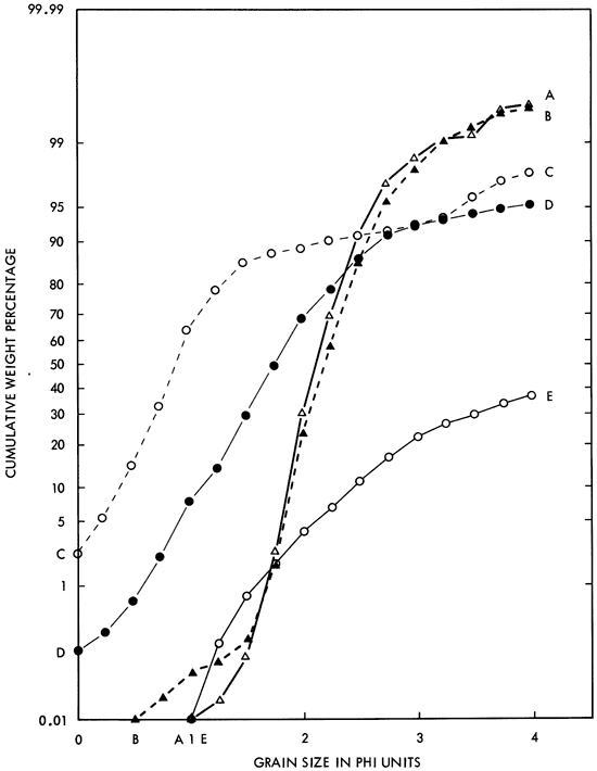
Figure 14--Log-probability plots of grain-size distributions of selected samples of Kiowa sandstone (triangles) above Longford Member and of Longford (?) sandstone (circles) collected near top of member. A) Kiowa sandstone, SE SW sec. 17, T. 10 S., R. 1 E., Clay County. B) Longford (?) sandstone, NW sec. 27, T. 8 S., R. 2 E., Clay County.
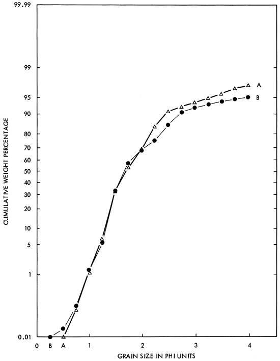
Table 3--Results of sieve analyses of two samples of Longford sandstone and one sample of Longford (?) sandstone compared with results from 23 samples from other parts of the Kiowa Formation. Parameters from Inman 1952) and Folk and Ward (1957). Data for Kiowa sandstone samples from Franks 1966).
| Median diameter (mm) |
Phi median diameter |
Phi graphic mean |
Phi deviation measure (sorting) |
Phi inclusive graphic standard deviation |
Phi skewness measure |
Phi inclusive graphic skewness |
Phi graphic kurtosis |
Normalized phi graphic kurtosis |
||
|---|---|---|---|---|---|---|---|---|---|---|
| Longford samples |
Curve C, Fig. 13 |
0.54 | 0.89 | 0.96 | 0.46 | 0.72 | +0.22 | +0.51 | 2.40 | 0.71 |
| Curve D, Fig. 13 |
0.29 | 1.77 | 1.84 | 0.57 | 0.78 | +0.18 | +0.57 | 1.80 | 0.64 | |
| Longford (?) |
Curve B, Fig. 14 |
0.31 | 1.67 | 1.84 | 0.55 | 0.69 | +0.47 | +0.89 | 1.44 | 0.58 |
| 23 Kiowa samples |
Mean | 0.20 | 2.30 | 2.34 | 0.37 | 0.42 | +0.13 | +0.22 | 1.35 | 0.56 |
| Standard Deviation |
0.53 | 0.53 | 0.13 | 0.17 | 0.13 | 0.14 | 0.46 | 0.06 | ||
| Range | 0.54, 0 10 |
0.90, 3.32 |
0.96, 3.29 |
0.22, 0.68 |
0.22, 0.78 |
-0.11, +0.48 |
-0.05, +0.60 |
0.87, 2.90 |
0.48, 0.70 |
|
Prev Page--Introduction, Stratigraphic Framework || Next Page--Depositional Environments
Kansas Geological Survey, Geology
Placed on web March 10, 2009; originally published November, 1979.
Comments to webadmin@kgs.ku.edu
The URL for this page is http://www.kgs.ku.edu/Publications/Bulletins/219/03_desc.html