![]()
Prev Page--Contents || Next Page--Description
Introduction
The Kiowa Formation (Early Cretaceous, Albian) of Kansas (Cragin, 1889, 1894) is a heterogeneous unit made up of shale and other clay rocks, siltstone, sandstone, and coquinoid limestone or mollusk-shell conglomerate. These rocks formed from sediments that were deposited in a complex of marine and marginal-marine environments as the Early Cretaceous sea of the southern Western Interior spread northeastward across gentle terrain developed mainly on Permian rocks, and onto the gently dipping western flank of the Nemaha anticline in central Kansas. A conspicuous siltstone marks the lower parts of the Kiowa Formation along most of the eastern fringes of its outcrop belt in north-central Kansas (Figs. 1, 2). The siltstone rests directly on weathered Lower Permian rocks in places, but, more commonly, it overlies distinctive assemblages of claystone, mudstone, siltstone, sandstone, and carbonaceous beds that rest unconformably on Permian rocks. The assemblage of rocks below the conspicuous siltstone locally encloses and contrasts sharply with lenses or tongues of more typical, olive-gray, facies-equivalent Kiowa shale. The name "Longford Member of the Kiowa Formation" is proposed for the conspicuous siltstone and the underlying assemblages of Kiowa rocks. Except for informal use of the name "Longford" to refer to the same body of rocks (Franks, 1966, 1975), the name has not been applied to stratigraphic units in North America (G. V. Cohee, 1969, written communication).
Figure 1--Index map of Kansas showing generalized outcrop belts of Lower Cretaceous Kiowa Formation (Kk, unpatterned), its Longford Member (Kkl, cross- hatched), overlying Dakota Formation (Kd, coarse stipples), and underlying Cheyenne Sandstone (Kc, fine stipples), as well as approximate axial trace of Nemaha anticline. Arrows indicate orientation of major modes of cross-strata dip-bearings measured in Kiowa sandstone: arrow pointing to southwest shows direction of inclination of depositional slope. CL, Clay County; DI, Dickinson County; EL, Ellsworth County; MA, Marion County; McPH, McPherson County; OT, Ottawa County; RI, Rice County; SA, Saline County; WA, Washington County. Numbered dots mark locations of measured sections described in Appendix B and shown in Plate 2.
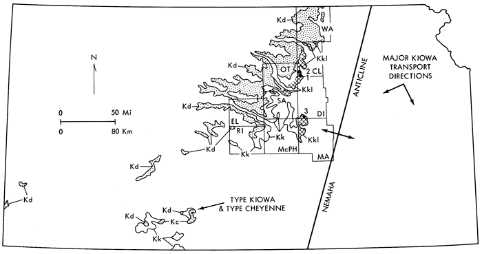
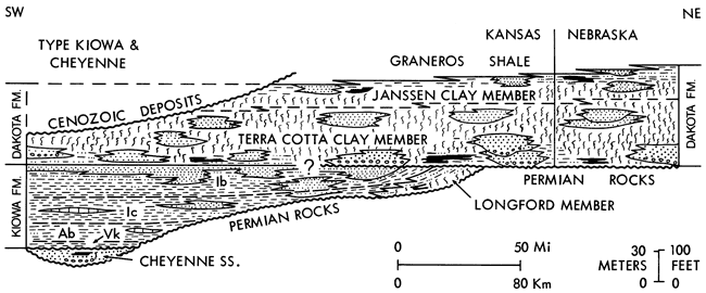
Figure 2--Schematic cross section, showing stratigraphic relations of basal Cretaceous beds cropping out in southern and north-central Kansas. At least locally, Dakota Formation rests disconformably on Kiowa Formation; question mark indicates uncertain extent of disconformable contact. Biostratigraphic zones in Kiowa Formation after Scott (1970b): Vk, Venezoliceras kiowanum zone; Ab, Adkinsites bravoensis zone; Ic, Inoceramus comancheanus zone; Ib, Inoceramus bellvuensis zone.
A formal stratigraphic name is appropriate for Longford rocks because they are important to an understanding of Kiowa stratigraphy and sedimentation:
- Longford rocks form a recognizably different and distinctive part of the Kiowa Formation.
- The member is of limited stratigraphic and geographic extent on the outcrop in north-central Kansas (Figs. 1, 2).
- Despite their restricted occurrence near the base of the Kiowa Formation, Longford rocks have been mistaken for parts of the Dakota Formation (Early? and Late Cretaceous), which overlies the Kiowa Formation. Schoewe (1952), for example, assigned lignitic beds in the Longford Member in Dickinson County (Fig. 1) to the Dakota Formation. Appreciable thicknesses of overlying Kiowa rocks were overlooked during geological mapping of Clay and Ottawa counties, apparently because Longford rocks were mistaken for parts of the Dakota Formation (Walters and Bayne, 1959; Mack, 1962). Had the Longford Member been recognized as a formal stratigraphic unit at the time those projects were under way, the confusion probably could have been avoided.
- Some Longford clay rocks and siltstone resemble rocks in the Cheyenne Sandstone (Early Cretaceous), which underlies the Kiowa Formation in parts of southern Kansas (Figs. 1, 2). It might be tempting, therefore, to treat Longford rocks as part of the Cheyenne Sandstone, even though the outcrop areas of the two units are isolated from each other, and no direct stratigraphic connection seemingly exists between the units in the subsurface (Franks, 1975; Scott, 1970b).
- The distribution of Longford rocks on the outcrop and the depositional strike inferred for the Kiowa Formation (Franks, 1966, 1975) indicate that Longford rocks, or their analogues, may be present in the subsurface of southern or central Nebraska. Recognition of the Longford Member in Kansas, therefore, may aid in unravelling Cretaceous stratigraphy and sedimentation in areas to the north of Kansas.
- Lastly, although environmental interpretations technically play no part in the definition of formal stratigraphic units, Longford rocks warrant special attention because they constitute the easternmost record of paralic and continental sediments that accumulated during transgression of the Kiowa sea.
Longford rocks and facies-equivalent parts of the Kiowa Formation form an unusually complete sedimentary record of marine transgression along a barrier-island coast. Papers by Fischer (1961), Kraft (1971), Ryer (1977), and Swift (1968) describe some of the sedimentary records left by marine transgression along barrier-island coasts. One of the chief elements of transgression noted by those authors is erosion of barrier-island, lagoon, bay, inner shore, and even continental deposits as barrier systems migrate landward. The erosion leads to the development of transgressive disconformities within and beneath the transgressive sequence and results in varying degrees of destruction of the sedimentary records generated in coexisting marginal-marine, paralic, and fluvial environments of deposition. Consequently, off shore marine sediments commonly rest disconformably on coastal-plain deposits (Ryer, 1977, p. 183). The Longford Member and associated Kiowa rocks, in contrast, are notable for the absence of either marked or extensive transgressive disconformities that separate them from overlying open-sea deposits, and for the preservation of barrier-island, bay or lagoon, inner shore, estuarine, and fluvial deposits. The completeness of the Longford record also offers insight into the mechanisms by which Kiowa shorelines shifted landward during transgression.
Interpretation of the record of sedimentary environments preserved in Longford rocks, however, is not easy. Except for plant fossils, mainly of uncertain affinities, no environmentally significant fossils, either vertebrate or invertebrate, were found. Moreover, except for the siltstone that marks the top of the member, Longford rocks are not especially well exposed. Consequently, interpretations are based largely on scattered exposures, few of which span appreciable thicknesses of the member. Therefore, vertical and, particularly, lateral sequences, other than rather general ones, are hard to establish. Nonetheless, analysis of the Longford record depends on extensive application of Walther's law of facies succession (Walther, 1894). That principle states, in effect, that the records of depositional environments that existed side-by-side are preserved in vertical sequences of strata as a result of lateral migration of the environments with time. Thus, lateral facies relationships can be deciphered by study of vertical sequences of beds, provided that no significant erosional discontinuities interrupt the vertical successions of strata (Selley, 1976, p. 309-310).
Interpretation of the Longford depositional record also is handicapped because many of the depositional models that have been devised for the study of ancient rocks are based primarily on research in modern environments where relatively thick and complete progradational sequences formed (cf. Klein, 1971, 1972; Matthews, 1974; Selley, 1970). Because Longford sedimentation took place as the Kiowa sea transgressed landward, thick progradational sequences of strata had little opportunity to form. Not only are records of many of the individual depositional environments thinned, but also the sequences of beds in which some of the environments are recorded are upside down compared to the sequences in widely used progradational models.
This report summarizes a reconnaissance study of Longford rocks that stems from a larger study of the Kiowa and Dakota formations of central Kansas (Franks, 1966, 1975). Pertinent details of work methods used in the study of Longford rocks are given in Appendix A, whereas details on work methods used in the study of associated Kiowa sandstone and shale are in the 1966 report. Descriptions of measured sections are given in Appendix B. Nomenclature for formations follows current Kansas Geological Survey practice (Zeller, 1968). The name "mudstone" is used as a field term to refer to nonfissile sedimentary rocks composed primarily of subequal proportions of clay- and silt-sized particles. Usage generally follows that of the first definition in the Glossary of Geology (Gary and others, 1972). The term "claystone" is applied to nonfissile rocks composed mainly of clay-sized particles, and the term "clay rock" is used generically to encompass mudstone, claystone, and shale. Terminology for stratification generally follows that of McKee and Weir (1953). Part of the report is devoted to a brief description of the stratigraphic framework represented by the Cheyenne, Kiowa, and Dakota formations in Kansas because of the importance of these rock units to an understanding of Longford stratigraphy and sedimentation. Review of the salient features of the Cheyenne, Kiowa, and Dakota formations also is appropriate because of the similarity of some Longford rocks to rocks in those units.
Stratigraphic Framework
The Basal Cretaceous Beds of Kansas
The basal Cretaceous section in Kansas includes, in ascending order, the Cheyenne, Kiowa, and Dakota formations (Fig. 2). Outcrops of the Cheyenne Sandstone, which probably is early late Albian in age (Scott, 1970b; Berry, 1922), are restricted to the vicinity of its type area in southwestern Kansas (Fig. 1). The Kiowa Formation, which is of late Albian age (Scott, 1970a, 1970b), is exposed in both southwestern and north-central Kansas. The Dakota Formation, which probably spans the Albian-Cenomanian boundary (Eicher, 1965; Franks, 1966, 1975), crops out chiefly in north-central Kansas. The three formations are separated from underlying Permian rocks by a transgressive disconformity along which they show progressive northeastward overlap of older strata (Fig. 2). The Cheyenne, Kiowa, and Dakota formations record an initial transgressive-regressive cycle of Cretaceous sedimentation along the Kansas portions of the Early to mid-Cretaceous seaway that transected western North America (Franks, 1966, 1975; Scott, 1970b). The rocks of the Longford Member of the Kiowa Formation are the easternmost record of continental and paralic sediments deposited during the transgressive phase of the Cheyenne-Kiowa-Dakota cycle.
Cheyenne Sandstone
In the type area of the Cheyenne and Kiowa formations (Fig. 1), the Cheyenne Sandstone marks the base of the Cretaceous System. It rests on Upper Permian rocks and has a maximum thickness of about 94 ft (29 m) (Latta, 1948). West of the type region, the Cheyenne Sandstone is absent and the Kiowa Formation rests directly on Permian rocks. No Cheyenne rocks are recognized in scattered Cretaceous outliers south and west of the type area, either in Kansas or in nearby parts of Oklahoma (Franks, 1975; Scott, 1970a, 1970b). The Cheyenne Sandstone thins eastward from its type area, and both the Cheyenne and Kiowa formations disappear northward beneath an extensive blanket of Pleistocene deposits. About 20 mi (32 km) northward from its type locality, the Cheyenne Sandstone apparently pinches out beneath the Kiowa Formation along the western flank of the Pratt anticline in the subsurface of northwestern Pratt County (Layton and Berry, 1973). The formation does not crop out in central Kansas (Franks, 1966, 1975; Plummer and Romary, 1942; Scott, 1970a, 1970b), but Fent (1950, p. 56) suggested that conglomeratic beds of varicolored sandstone and shale (and presumably also white siltstone) exposed along the Permian-Cretaceous unconformity at several places in eastern Rice County (Fig. 1) might be outliers of Cheyenne Sandstone. The beds, however, are basically similar to those seen elsewhere in central Kansas where pebbles of chert and other resistant materials are concentrated along the Permian-Cretaceous unconformity.
The name Cheyenne has been applied to widespread sandstone in the subsurface of western Kansas, but Scott (1970b), using wireline logs, was unable to correlate at least some of that sandstone with type Cheyenne Sandstone. Sequences of nearly white to greenish-gray siltstone, shale, and fine-grained sandstone at the base of the Kiowa Formation in the shallow subsurface to the north and northeast of the type area have been correlated with the Cheyenne Sandstone (Fent, 1950; Latta, 1950; McLaughlin, 1949). Other than position at the base of the Cretaceous System, however, the sequences of silty to shaly and sandy beds may have little in common with rocks exposed in the type area of the Cheyenne Sandstone. The possibilities of overextension and miscorrelation of the formation warrant special consideration in applying the name Cheyenne Sandstone in the subsurface of western Kansas (Franks, 1975).
The abundant sandstone and relatively scarce siltstone and clay rocks in the Cheyenne Sandstone form an upward fining sequence that probably was deposited in fluvial and estuarine environments, largely before the late Albian Kiowa sea invaded southwestern Kansas (Franks, 1975; Scott, 1970b). Silty clay rocks intercalated with sandstone in the lower parts of the formation are light gray, but, in places, they are blotched by reddish-brown hematitic mottles. They resemble clay rocks in both the Dakota Formation and the Longford Member of the Kiowa Formation. Clay rocks higher in the Cheyenne Sandstone tend to be dark gray to brownish gray, and to contain abundant carbonaceous matter. They too resemble clay rocks in parts of the Dakota Formation and the Longford Member of the Kiowa Formation. Cheyenne clay rocks are composed chiefly of smectite and kaolinite. They contrast with the illitic and chloritic clay rocks of the Permian System in Kansas, but, like Longford clay rocks, they are compatible with derivation by reworking of fossil soils such as those that are preserved along the Permian-Cretaceous unconformity in Kansas (Franks, 1975).
Kiowa Formation
The Kiowa Formation rests disconformably on the Cheyenne Sandstone in their common type area in southwestern Kansas (Fig. 1) (Franks, 1975; Scott, 1970b). Elsewhere on the outcrop, the formation rests on Permian rocks, but in the subsurface of western Kansas, it overlies widespread sandstone that probably is not coextensive with the Cheyenne Sandstone of the type area (Franks, 1975; Scott, 1970b). In north-central Kansas, the Kiowa Formation overlaps progressively older Lower Permian rocks to the northeast. Along the gently dipping western flank of the Nemaha anticline (Fig. 1), the formation, in turn, is truncated and overlapped by the Dakota Formation about 30 mi (48 km) south of the Kansas-Nebraska border (Fig. 2). As the Kiowa Formation pinches out, the northernmost recognizable Kiowa exposures are of the Longford Member.
The Kiowa Formation records the invasion of the Early Cretaceous epicontinental sea into Kansas, and the numerous fossils studied by Twenhofel (1924) and Scott (1970a, 1970b) testify to the generally marine, if somewhat brackish-water, nature of Kiowa sedimentation. The distribution and grain sizes of Kiowa sandstone, the orientation of cross-strata in the sandstone, the distribution of Longford rocks, and the character and distribution of faunal assemblages all indicate that the Kiowa depositional slope generally was inclined to the southwest (S 60° W to S 70° W, Fig. 1), and that the Kiowa sea transgressed northeastward across Kansas (Franks, 1966, 1975; Scott, 1970a, 1970b). Variations in thickness of the formation generally accord with these data. The unit is thickest in its type area, where it is about 300 ft (91 m) thick (Latta, 1948). In north-central Kansas, maximum thickness is found near the southern end of the outcrop belt (Fig. 1) and approximates 150 ft (46 m). The formation thins irregularly northward from there until the pinchout between the Dakota Formation and Permian rocks is reached near the Kansas-Nebraska line.
Shale traditionally has been considered to be the kind of rock most characteristic of the Kiowa Formation. Kiowa shale generally is medium to dark gray and weathers olive gray to olive brown. Most of the shale is thinly laminated, fissile, and plastic when wet. Imprints of pelecypods, together with sorted assemblages of fish scales, teeth, and bone fragments, as well as glauconite pellets, are found locally along bedding planes in the shale. Illite, mixed-layer illite-smectite, and smectite are the major clay minerals. Kaolinite also is present and it is more abundant upward in the formation, whereas smectite (chiefly Ca-montmorillonite) is more abundant near the base (Franks, 1966). The mineralogy of typical Kiowa shale contrasts sharply with that of clay rocks in the Longford Member.
Laminae and beds of siltstone and very fine grained sandstone are scattered through sections of Kiowa shale, as are beds of coquinoid limestone or mollusk-shell conglomerate. Many of the siltstone and sandstone beds are fossiliferous or are mottled by burrowing. Concretionary masses and layers of impure siderite (clay-irons tone) and calcareous cone-in-cone structure are common, especially in north-central Kansas (Franks, 1969a, 1969b). Most Kiowa shale, together with the enclosed beds of siltstone, sandstone, and coquinoid limestone, is a product of sedimentation in somewhat brackish, open-sea environments (Scott, 1970a, 1970b; Franks, 1975). Although shale is common in the Kiowa Formation, the type section in southern Kansas is unusual in that it contains so much shale and so little sandstone.
Extensive bodies of dominantly fine- to medium-grained sandstone in the Kiowa Formation can be divided into two genetically significant types of deposits (Franks, 1966, 1975): thick, lenticular deposits as much as 100 ft (30 m) thick, and thin, sheet-like deposits less than 10 ft (3 m) thick. Although sandstone bodies of these types occur throughout the Kiowa Formation in north-central Kansas, they are most common in the upper parts of the unit. They contrast with the thinner beds of very fine grained sandstone and siltstone that are scattered through sections of Kiowa shale. Some of the thick, lenticular deposits of sandstone probably formed as barrier bars and related shoreface accumulations. Some also show sedimentary structures and partial sequences of structures that accord with the migration of tidal inlets and associated spit platforms (Kumar and Sanders, 1974). Apparently, linear clastic shorelines (Selley, 1970) dominated Kiowa sedimentation during maximum transgression of the Kiowa sea into north-central Kansas (Franks, 1975).
Fossil assemblages, sedimentary structures, and ripple-laminated gradations into underlying shale indicate that the sheet-like deposits of sand also accumulated in nearshore realms (Franks, 1966, 1975; Scott, 1970a, 1970b). Widespread sheet-like sandstone that marks the top of the Kiowa Formation is, in part, compatible with deposition as delta-front sheet sands of shoal-water deltaic complexes (Franks, 1975). Their accumulation marked the onset of widespread regressive sedimentation that heralded deposition of the overlying Dakota Formation.
Dakota Formation
The Dakota Formation marks the climax of the regressive phase of sedimentation in the transgressive-regressive depositional cycle recorded by Cheyenne, Kiowa, and Dakota rocks. The Dakota Formation, which is about 250 ft (76 m) thick, rests both disconformably and conformably on Kiowa rocks. Evidence of disconformable relationships is seen best where lenticular deposits of fluvial sandstone fill scours that were eroded into underlying Kiowa deposits (Franks, 1966, 1975). Additional evidence of disconformable relationships is found along the pinchout of the Kiowa Formation in north-central Kansas (Figs. 1, 2). As the Kiowa-Dakota contact is followed northward, sandstone marking the top of the Kiowa Formation is truncated, then underlying Kiowa shale and sandstone are truncated, and the last easily recognized manifestation of the Kiowa Formation is the siltstone that marks the top of the Longford Member near the base of the Kiowa Formation. Conformable contacts lack evidence of pre-Dakota weathering and erosion of uppermost Kiowa rocks. Locally, sandstone at the top of the Kiowa Formation grades sharply upward into overlying Dakota clay rocks (Bayne and others, 1971, measured section 5, p. 75-76), or beds and lenses of ripple-marked or other sandstone similar to that in the Kiowa Formation are enclosed by basal Dakota clay rocks (Bayne and others, 1971, p. 16; Franks, 1975, p. 491-497).
The Dakota Formation is noted for its abundant lenticular bodies of sandstone, but kaolinitic clay rocks amount to 60 or 70 percent of the aggregate thickness of the unit. Plummer and Romary (1942) divided the Dakota Formation of central Kansas into two members based on the characteristic colors of the clay rocks. The Terra Cotta Clay Member, which comprises approximately the lower two-thirds of the formation, is characterized by light-gray claystone and mudstone that are splotched by abundant, red, hematitic mottles. The Janssen Clay Member, which comprises approximately the upper third of the formation, includes abundant gray and dark-gray clay rocks as well as lignite and other carbonaceous matter. Gray clay rocks and sparse lignitic layers also occur at numerous localities at the base of the Dakota Formation (Plummer and others, 1963). These gray clay rocks and the associated carbonaceous materials appear to be remnants of delta-plain sediments that were deposited in a complex of shoal-water deltas that formed an important part of the early stages of Dakota sedimentation (Franks, 1975). The red-mottled clay rocks that characterize the bulk of the Terra Cotta Clay Member formed primarily as overbank deposits of streams that flowed southwestward across Kansas as alluvial-plain environments became established. The sediments that formed the gray clay rocks and associated carbonaceous beds, siltstone, and sandstone of the Janssen Clay Member were deposited under the influence of the transgressing, Cenomanian Graneros sea (Franks, 1966, 1975; Siemers, 1971, 1976). Except for their highly kaolinitic nature, and for the related physical properties that depend on it, many of the clay rocks in the Dakota Formation are similar to those in the Longford Member of the Kiowa Formation. The similarity locally poses problems of interpretation, especially near the pinchout of the Kiowa Formation.
Permian-Cretaceous Unconformity
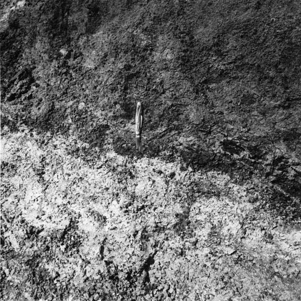
Some of the characteristics of the unconformity that separates Permian and Cretaceous beds in Kansas (Greene, 1910) are important to a study of the Longford Member. The unconformity is part of a regional, transgressive disconformity that also marks the base of the Longford Member (Fig. 2). Reworking of fossil soils and lag deposits, whose remnants are preserved locally along the unconformity in central Kansas, provided some of the sedimentary materials now incorporated in the Cretaceous beds above the unconformity (Fig. 3). Relief developed on the ancient erosion surface also affected the thickness of Longford sediments that accumulated from place to place.
Figure 3--Permian-Cretaceous contact at base of Longford Member, near cen. SE sec. 23, T. 16 S., R. 1 E., Dickinson County (units 2 and 3, measured section 3, Appendix B and Pl. 2). Pocket knife, about 15 cm long, marks contact. Handle rests against brownish-gray Longford mudstone and claystone (dark gray in photograph); blade penetrates dusky-red (very dark gray in photograph) top of variegated soil developed on normally olive Wellington Formation (Permian) mudstone or shale. Note fragments of dusky-red and light-colored regolith incorporated in basal Longford clay rock; one dusky-red fragment (very dark gray in photograph) is at left edge of knife handle.
The Permian-Cretaceous unconformity in north-central Kansas is a mature erosion surface. It commonly shows as much as 50 ft (15 m) of local relief over distances as great as a mile (1.6 km). In some areas, local relief approximates 75 to 100 ft (25 to 30 m). Pebbles and granules of chert, silica-cemented sandstone, quartzite, and "vein" or pegmatitic quartz (Table 1) are concentrated in the basal parts of the Cretaceous units above the unconformity in many places. The pebbles, which generally measure appreciably less than 6 cm in long diameter, occur primarily on, or on the flanks of, topographic highs developed on underlying Permian rocks. The enclosing matrix ranges from sandstone to mudstone, and pebbles in sandstone may be several feet above the actual base of the Cretaceous units. The pebbles and granules are thought to be relicts of a thin lag deposit of gravel that originally was scattered widely over the erosion surface. Reworking of the lag deposits continued as topographic lows were formed, and filled with Cretaceous sediments. The pebbles in the Longford Member and elsewhere at the base of the Cretaceous section in north-central Kansas were derived mainly from Paleozoic sedimentary rocks in the continental interior, but the pebbles of metamorphic or igneous material ultimately may have been derived from the crystalline terrains of the central Appalachians, if they came from the same sources as some of the heavy minerals in Kiowa and Dakota sandstone (Franks, 1966, 1975).
Table 1--Composition of pebbles in fine-grained Longford sandstone in NW sec. 27, T. 8 S., R. 2 E., Clay County, Kansas. Percentages based on a count of 180 pebbles.
| Pebbles | Percentages | |
|---|---|---|
| Chert | 69 | |
| white, porous | 39 | |
| white, dense | 6 | |
| black to brown, fine-grained | 14 | |
| black to brown, coarse | 10 | |
| Silica-cemented Sandstone | 1 | |
| Quartzite | 15 | |
| Quartz Schist | 1 | |
| "Vein" or Pegmatitic Quartz | 14 | |
The relict soil profiles preserved at many places along the unconformity generally are less than 4 ft (1.2 m) thick. The upper few feet of normally reddish- brown or olive-gray Permian rocks were extensively bleached or variegated prior to deposition of the overlying Cretaceous sediments (Fig. 3; measured sections 1 and 3, Appendix B and Pl. 2). Illitic and chloritic or vermiculitic Permian siltstone, mudstone, and shale (Swineford, 1955) were converted to clay-mineral assemblages rich in smectite, kaolinite, and, locally, halloysite (Franks, 1966). The fossil soils contain only trace amounts of chloritic or vermiculitic components. The soils commonly show a progressive upward change from smectite-rich assemblages to kaolinite-rich assemblages. The weathering sequence is similar to that described by Altschuler and others (1963) and Altschuler and Dwornik (1964) in which smectite is generated by weathering of mica- and chlorite-like parent minerals, and kaolinite in turn is formed by weathering of smectite.
Keller (1964) observed that smectite (montmorillonite) is generated under conditions of weathering that differ from those under which kaolinite and related minerals form, although both processes may go on side-by-side, or in different parts of the same soil profile. Formation of smectite requires fairly abundant cations in solution in the soil, whereas removal of both silica and cations is essential to the production of kaolinite. Provided that pH in the soil is low, drainage need not be good for generation of kaolinite. Formation of halloysite nodules at least locally in the soil profiles developed on Permian rocks in central Kansas (measured section 3, Appendix B; Franks, 1966) also indicates that the soil was not well drained, and that an acid pH prevailed. The abundance of kaolinite in the upper parts of the soils and localized occurrence of halloysite are highly suggestive of weathering under humid, subtropical conditions (Millot, 1970; Mohr and others, 1972; Parham, 1969, 1970; among others).
Other features also are compatible with development of the fossil soils under conditions of low relief, poor drainage, and humid tropical to subtropical climates. Like the pebbles along the unconformity, the fossil soils are preserved mainly on topographic highs developed on the Permian rocks prior to deposition of the overlying Cretaceous beds, whereas least-altered Permian rocks are found primarily in topographic depressions along the unconformity (cf. measured section 1, Appendix B). The unconformity apparently underwent a period of renewed erosion prior to deposition of the Cretaceous beds, and the unconformity must have shown even less relief at the time the soils were generated than it does now. The general thinness of the soil profiles may stem from repeated erosion during their development, but the thinness and the marked upward changes in mineralogy accord with formation of the soils on relatively impermeable, clayey rocks along a poorly drained erosion surface of low relief (Birkeland, 1974, p. 99; Ollier, 1969, p. 9192). Similarly, the bleaching and variegation that took place during development of the soils is suggestive of gleying or the dissolution and redistribution of iron oxides under conditions of impeded drainage and fluctuating water content (Birkeland, 1974, p. 118).
When the weathering that generated the fossil soils took place is problematic. The weathering predates the Cretaceous beds above the unconformity. It also predates the inferred episode of erosion that preceded deposition of the Cretaceous sediments. The erosion surface that separates Permian and Cretaceous strata in north-central Kansas, moreover, is not only a transgressive disconformity, but also a composite unconformity (Weller, 1960, p. 396). The single erosion surface in central Kansas is represented by a number of unconformities in the subsurface of western and southwestern Kansas, and in nearby parts of Colorado, New Mexico, and Oklahoma (Baldwin and Muehlberger, 1959, p. 31-51; Fader and others, 1964, p. 15; McLaughlin, 1954, p. 82-96; Merriam, 1963, p. 71-77, Fig. 33; Schoff and Stovall, 1943, p. 43-71; Voegeli and Hershey, 1965, p. 52-58; Zeller, 1968, p. 53-54). There, unconformities separate Permian from Triassic strata, Triassic from Jurassic strata, and Jurassic from Cretaceous strata; other unconformities occur within the Triassic and Jurassic sequences. Casual field observations and a review of the literature suggest that no well-developed fossil soils are present in or beneath pre-Cretaceous Mesozoic beds where they occur above Permian rocks, either in Kansas or in nearby parts of Colorado, New Mexico, or Oklahoma. If true, it may mean that the fossil soils along the Permian-Cretaceous unconformity in Kansas developed primarily during pre-Kiowa or pre-Cheyenne Early Cretaceous time. Nonetheless, the mineralogy of the basal Cretaceous clay rocks seemingly reflects the mineralogy of the fossil soils, which probably were widespread throughout the continental interior (cf. Andrews, 1958, and Parham, 1970). As is true for the soil profiles, many of the Cretaceous clay rocks are composed primarily of smectite and kaolinite, and they contain only trace amounts of chloritic or vermiculitic clays (Franks, 1966). These relationships also apply to the Longford Member of the Kiowa Formation.
Prev Page--Contents || Next Page--Description
Kansas Geological Survey, Geology
Placed on web March 10, 2009; originally published November, 1979.
Comments to webadmin@kgs.ku.edu
The URL for this page is http://www.kgs.ku.edu/Publications/Bulletins/219/02_intro.html