![]()
Prev Page--Typical Limestone || Next Page--Oklahoma
Stanton Formation in the Detrital Facies Belt of Montgomery County
Previous Work
Early investigations recognized that the Stanton Formation grades southward from a sequence consisting mainly of thick limestones into two or more thin beds of impure limestone intercalated with thick sandstone and shale in central and southern Montgomery County, Kansas. Schrader (1908, referring to the Stanton as the Piqua), mapped two discrete zones of limestone across this area. Newell (1933, p. 88) recognized the lower zone as the Captain Creek Member. Both writers implied that the upper zone represented one horizon inasmuch as they equated the limestone at Tyro (now termed the Tyro bed) with that dipping beneath the floodplain of Little Caney Creek at Caney (now known to be the South Bend Member); as a result, a large portion of the sandstone and shale within the Stanton were mapped as the overlying formation (Schrader, 1908; Geologic Map of Kansas, 1937; see also Oakes, 1940a). Nevertheless, measured sections by Newell and a correlation cross section, all published in Moore (1937, p. 46-47), show that as many as three layers of limestone were recognized at this time as partially equivalent to the upper two limestone members of the Stanton.
More recently, Wilson (1957a, 1957b) correlated all the named members into the detrital facies belt. He traced the South Bend through Wayside and Havana to Caney and recognized it as stratigraphically well above the limestone at Tyro. He also applied the name Stoner Member to outcrops of two limestone beds (Rutland, Bolton) and a quartz siltstone bed (Timber Hill), all now known to be discontinuous with definite Stoner along outcrop. He considered the limestone at Tyro to be part of the Captain Creek Member, whereas both Schrader (1908) and Newell (1933) had placed this bed above the Captain Creek.
Immediately subsequent work generally follows that of Wilson. Harbaugh (1962) also considered the limestone at Tyro as probably equivalent to the Captain Creek, but previously be (1960, p. 224-226) correlated limestone now known to be Captain Creek in T. 33 S. to the Plattsburg. O'Connor (1962) mapped no distinction between the levels of the Captain Creek and Tyro at the base of the Stanton and along with Ball (1964), recognized and mapped most of the South Bend at the top and placed more of the intervening sandstones and shales into the Stanton Formation, as is shown on the more recent Geologic Map of Kansas (1964).
Present Stratigraphic Framework
Aided by the availability of accurate 7.5-minute topographic mapping (1959-1962), by suggestions from previous workers, and by field assistance mainly of J. M. Cocke, I have carried out a program of detailed facies mapping and bed tracing along the Stanton Limestone outcrop intermittently since 1966. The results of this work show that Stanton stratigraphy in the shale and sandstone-dominated sequence of the detrital facies belt of central and southern Montgomery County is best described within the framework of the three previously named limestone members, plus three new informally named limestone beds, a quartz siltstone bed, and several less well delineated limy horizons and quartz sandstone bodies (Plate 1; Fig. 4,5).
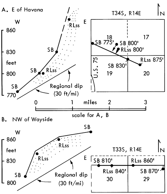
Figure 4--North-south cross section along strike of Stanton Formation and underlying units in central and southern Montgomery County, Kansas. Primary datum is top of Iola Limestone which is frequently exposed to east (Plate 1), well-defined Stanton units (especially Captain Creek and Tyro) serve as secondary datums between measurements up from Iola. East-west cross-section in southern T. 32 S. is given in Fig. 5. Solid vertical lines indicate field measurement with hand level; dashed vertical lines indicate estimation of thickness from outcrop elevations on 7.5-minute topographic maps (10-foot contour interval) with correction made for 30 feet per mile regional dip to west. Both types of measured sections are located by number in Appendix 1. Greater than regional westward dip of South Bend Member off west sides of thick Rock Lake sandstone bodies (illustrated in Fig. 6) causes westernmost exposures of South Bend to project eastward to within Eudora-Rock Lake interval at places from southern T. 33 S. through T. 35 S. Regional dip of 30 feet/mile is verified on Captain Creek exposures on Table Mound and bluffs to west, north of Elk River; on Tyro exposures in quarry northeast of Tyro and at either end of Hafer Run inlier; and on South Bend exposures along U.S. Rte. 75 between Wayside and Havana (see Plate 1). A larger version of this figure is available.
Symbols are standard except:
Convex-upward arcs--phylloid algal mound facies
Vertical lines--skeletal calcarenite
Blank in limestone unit--calcilutite, sponge-rich in Captain Creek and in South Bend in southern T. 33 S. and northern T. 34 S.
Abbreviations:
f--bryozoan-brachiopod-dominated diverse assemblage in Eudora and Stoner
m--mollusc-dominated assemblage in Eudora and lower Wann
THSB--Timber Hill siltstone bed
L-V siltstone--siltstone in top of Lane-Vilas Shale
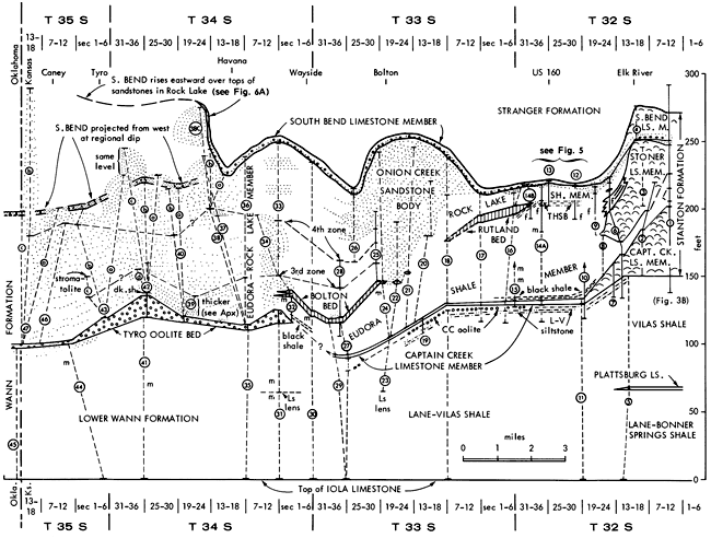
Figure 5--East-west cross section of Stanton Formation essentially along U.S. Rte. 160 at northern end of terrigenous detrital facies belt in southern T. 32 S. and northern T. 33 S., showing thickness variations not shown on Fig. 4. Measured sections numbered as on Fig. 4 are located in Appendix 1; section A was measured along north side of U.S. Rte. 160 in road ditch west of Coon Creek in SE 28-32-14. Basic datum is top of Captain Creek Limestone Member; secondary datum is base of South Bend Limestone Member between sections 14A (13) and A. Correlation of Timber Hill siltstone bed questioned between sections A and 10 because chips from "hard layer" in drillhole D (section 10) are lost, and probable siltstone lithology cannot be substantiated in laboratory.
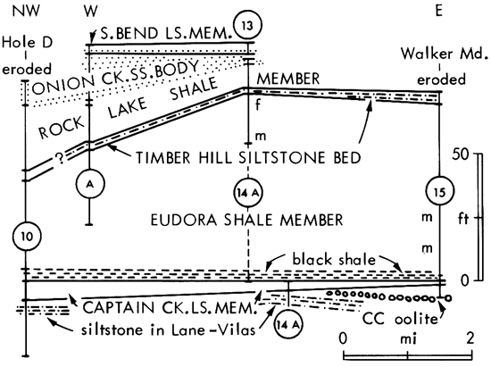
Figure 6--Two east-west cross sections, down dip, of upper part of Stanton Formation in southern Montgomery County, Kansas, showing greater than regional westward dips of South Bend Member (SB) off west sides of thick underlying sandstone bodies in Rock Lake Member (RLss). Datum is mean sea level obtained from 7.5-minute topographic maps with 10-foot contour interval.
Members
Of the three limestone members, the Stoner can be traced less than a mile into the terrigenous detrital facies belt, definite Captain Creek can be traced several miles across it, about halfway to the Oklahoma border, and the South Bend can be traced across it as far as the Oklahoma border. The two shale members, Eudora and Rock Lake, can be separated about halfway to the Oklahoma border, and a generalized Eudora-Rock Lake interval can be carried along with the South Bend and a newly named basal limestone bed (Tyro) up to the Oklahoma border.
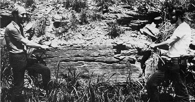
Captain Creek Limestone Member--From a known exposed maximum of 50 feet at the standard section (Fig. 3B; Fig. 4, meas. sec. 1) north of the Elk River, the Captain Creek thins southwestward in 2 miles through about 12 feet in the low escarpment south of the Elk River (Fig. 4, meas. sec. 7) to less than 5 feet in another 2 miles to the roadcut on U.S. Rte. 160 (Fig. 4, meas. sec. 14A). Mound facies of phylloid-algal calcilutite, in which large algal blades shelter spar-filled voids, dominates the rock type across this region of thinning and is apparent in the roadcut exposure. Invertebrates such as brachiopods, echinoderm pieces, and particularly sponges [Note: Most of these are the familiar small cylindrical and beaded calcisponges; a few are represented by fragments of spicular mats, many of which have the appearance of small elongate combs on random cuts.] become more noticeable southward and dominate some of the calcilutite in the roadcut exposure.
South of the U.S. 160 roadcut, the Captain Creek forms a low irregular escarpment that swings eastward around the foot of Walker Mound then south and westward toward Bolton (Plate 1). Throughout this portion of outcrop, the member averages 5 to 7 feet thick and consists of two 1- to 2-foot-thick layers of limestone separated by one to several feet of fossiliferous sponge-rich calcareous shale which is rarely exposed. The upper ledge is a distinctive dull orange to yellowish-brown weathering calcilutite dominated by small cylindrical and beaded calcisponges (Fig. 7) and containing various amounts of echinoderm debris, brachiopods, bryozoans, large irregular algal-invertebrate mats and encrustations (Fig. 8), and individual encrusting foraminifers. The lower ledge is an orangish-weathering oolite that contains scattered echinoderm, bryozoan, and brachiopod debris, most of which is oolitically coated. Quartz grains are present as nuclei, but are greatly subordinate to carbonate grains (pellets and skeletal pieces) in this function. Wilson (1957a) considered this oolite to be laterally equivalent to siltstone exposed to the north in the top of the underlying Vilas (= Lane-Vilas) Shale, but occurrence of oolite above siltstone in ditches along the east-west road bisecting the south one-half of section 17, T. 33 S., R. 15 E. (Fig. 4, meas. sec. 19), along with scarcity of quartz nuclei in the northernmost exposures of the oolite, argue against this correlation.
Figure 7--Surface of block of Captain Creek sponge calcilutite facies showing characteristic abundance of conspicuous beaded and cylindrical calcisponges. Blade of hammer visible is 10 cm long. From Patterson's hog farm, NE-NE 23-33-14.
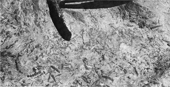
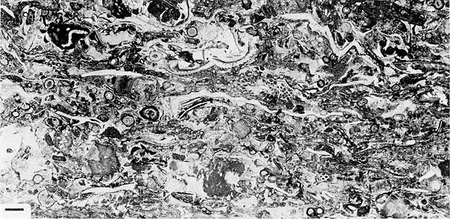
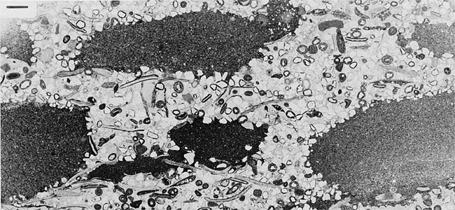
Figure 8--Thin section of Captain Creek sponge calcilutite facies showing conspicuous calcisponges (s) with probable algal-invertebrate mat (m) encrusting both sponges and mud surface; mat may possibly be considered "Ottonosia" in sense of Henbest (1963, p. 37) and consists largely of thin recrystallized layers, perhaps of archaeolithophyllid algae, alternating with thinner dark, generally micritic laminae, possibly of blue-green algal origin, augmented in places by encrusting foraminifers, fistuliporid bryozoans (b), and probable Tubiphytes (T). Scale in lower left is 1 mm long. From creek bed in SE-NW-SW 24-33-14.
West and south of Bolton, resistant sandstones higher in the Stanton bold up the hills that mark an irregular escarpment, and the Captain Creek is exposed only in certain creek beds and gullies on the lower slope. [Note: 4 The hill less than 1 mile northwest of Bolton, however, is held up by siltstone in the top of the Lane-Vilas Shale.] The oolite lenses out westward in less than 2 miles from Walker Mound as it is replaced by shale carrying small stromatolitic nodules (along W line near NW cor 6-33-15). Its southwestward gradation around Bolton (in SE 13-33-14) consists of less than 1 foot of slightly oolitic skeletal-pelletal calcarenite beneath the sponge-rich calcilutite. Its southernmost known exposure in SE-SW 25-33-14 along U.S. Rte. 75 southwest of Bolton (Fig. 4, est. sec. 27) contains abundant quartz nuclei and stromatolitically (osagia) coated fossils and lithoclasts. The layer of orangish-weathering sponge-rich calcilutite that dominates the Captain Creek throughout the region south of Walker Mound is traced definitely as far south as an outcrop exposure in the road ditch along U.S. Rte. 75 (near ctr N half NW 36-33-14) southwest of Bolton (Fig. 4, est. sec. 27), and with caution to the sponge-bearing argillaceous calcilutite blocks lying in the road ditch along W line NW 31-33-15 (Fig. 4, est. sec. 29).
About 1.2 mile south of this, across a region of poor exposure of this horizon, the Tyro oolite bed appears at or near the stratigraphic level of the Captain Creek. This probable correlation is indicated by the occurrence of the black shale facies of the Eudora (see later section) just above the Tyro in the road along the S line of NE-SW 6-34-15. The Tyro bed is considered a separate stratigraphic entity because it is not known to be definitely continuous with either facies of the Captain Creek along outcrop. Even though the Tyro is petrographically similar to the Captain Creek oolite, the latter is last seen grading southward into stromatolitic rock along U.S. Rte. 75; furthermore, it is separated from the black shale facies of the Eudora at Walker Mound by the sponge-rich calcilutite and several feet of calcareous shale, whereas the Tyro directly underlies the black shale in section 6-34-15.
The sponge-bearing limestone lenses exposed in SE-NE-SE 6-34-15 and at the bend in the road on S line SW-SW-SW 5-34-15, around the base of the hill west of Jefferson (Fig. 4, est. sec. 31), were originally correlated to the Captain Creek by Schrader (1908), Newell (1933), and for a time by myself. But these lenses are about 50 feet below the projected level of the Captain Creek as determined by the black shale at the base of the Eudora, and thus they lie within the Lane-Vilas sequence. Along with a similar exposure of sponge-bearing calcilutite about 40 feet below the Captain Creek (Fig. 4, est. sec. 23) in a road ditch west of Bolton (ctr S line SW 19-33-15), these limestone lenses in the Lane-Vilas may possibly correlate with the Plattsburg Limestone. The black shale reported by Newell (in Moore, 1937, p. 50) above these lenses at the base of the hill west of Jefferson (SW 5-34-15), which determined my earlier correlation with the Captain Creek, was not found in a recent visit (summer, 1974) after severe thunderstorm erosion had cleanly exposed the gray shale sequence for some distance above the limestone horizon.
Stoner Limestone Member--Although only 20 feet thick at the standard section (Fig. 3B), the Stoner thickens southwestward in 2 miles to 40 feet or more of phylloid algae-dominated mound facies in the bluffs along the north side of the Elk River (Plate 1; Fig. 4, est. sec. 3). About one mile to the south, across the river, in a gully extending eastward from Card Creek to the new north-south road ascending the north prong of Timber Hill, a little over 20 feet of thick-bedded Stoner mound facies is exposed, though with the base badly slumped (Fig. 4, meas. sec. 6). This is overlain (in the road ditch) by 11 feet of thin-bedded calcilutite containing phylloid algae and invertebrates intercalated with calcareous shale containing echinoderm debris, brachiopods, fenestellid, rhomboporid and fistuliporid bryozoans, and scattered corals. About 0.25 mile to the east the, Stoner crops out along a nearly disused north-south dirt road. At the north end (near NW-NW-NE 23-32-14) several feet of Stoner mound facies overlie "Eudora" fossiliferous shale. A little less than 0.4 mile to the south, on the west side of the road, Stoner limestone, packed with large blades of phylloid algae in a mud to spar matrix, pinches out into a sequence of shale that carries a diverse assemblage of invertebrates about 20 feet above the limestone pinchout (Fig. 4, est. sec. 9).
It is thus apparent that the Stoner Limestone Member passes southward abruptly into fossiliferous shale with gradation evident in the upper one-third of the gully-road ditch section (Fig. 4, meas. sec. 6) and presumably also in the lower beds (as indicated in the standard section, Fig. 4, meas. sec. 1). Limestone at or near the Stoner horizon is absent for at least 2 miles southward, and that which does appear (Rutland bed) displays a distinctly different rock type from any seen in the Stoner. Moreover, the siltstone (Timber Hill bed) that is exposed at places along U.S. Rte. 160 and was considered a probable or possible equivalent to the Stoner by Wilson (1957a) and Harbaugh (1962) is neither known to be continuous with the Stoner nor is lithologically compatible with it; therefore, it should be considered nothing more than a lens within the shale sequence to the south. All limestones within the Stanton south of the Stoner pinchout are given new informal names as beds, or left unnamed, in order to emphasize the lack of continuity along outcrop between them and the Stoner Member.
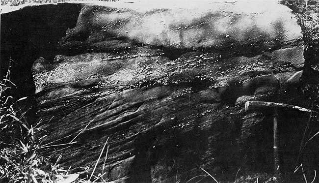
South Bend Limestone Member--From its thickest development of 24 to 30 feet along the Elk River just south of Elk City, the South Bend Member thins abruptly southward. Some of the thinning can be observed in the quarry along U.S. Rte. 160 just south of the river (Plate 1, Fig. 4, meas. sec. 4). The lower portion of the member, consisting of thin- to medium-bedded calcilutite alternating with quartz sandstone which is conglomeratic at the base, averages about 5 feet in thickness around the entire quarry. In contrast, the upper portion consists of about 20 feet of massive phylloid-algal calcilutite and echinoderm-rich calcarenite in the north wall but thins, in about 300 feet across the quarry, to 13 feet of medium-bedded skeletal calcilutite with subordinate algae in the south wall.
Farther southward and eastward in exposures around Timber Hill and along U.S. Rte. 160 (Plate 1), the South Bend consists of about 4 to 5 feet of yellowish to orangish-weathering skeletal calcilutite containing abundant echinoderm debris, with brachiopods, bryozoans, some phylloid algae, and calcisponges. The lower 1 to 2 feet carry abundant coarse quartz sand grains, locally oolitically coated, either scattered through the calcilutite or sufficiently concentrated to form a basal sandstone (Fig. 9). In many places conglomeratic sandstone (Fig. 10) characterizes the base of the South Bend (SW 36-32-14; NE and SW 11-33-14; and commonly southward). Pebbles in the conglomerate (Fig. 11) are mainly calcilutite, but include shale, siltstone, muddy sandstone, wood fragments and chert. Skeletal material ranges from whole brachiopods and large echinoderm pieces down to sand-size fragments of the above groups and of bryozoans, molluscs and foraminifers. Thus the two-fold lithologic subdivision characteristic of the South Bend in the north is apparent also south of the algal-mound facies belt and allows the member, only 2 to 4 feet thick, to be traced easily southward, marking the top of the Stanton Formation up to the Oklahoma border southwest of Caney.
Figure 9--South Bend Limestone Member consisting of skeletal calcilutite (behind hammer handle) grading downward into coarse quartz sandy calcilutite (around hammer head), which grades downward into less calcareous quartz sandstone, probably featheredge of Onion Creek sandstone body (Rock Lake Member) with small channel fill (lower right) overlying shale of Rock Lake Member. Roadcut on east side of Timber Hill near ctr W line NW 25-32-14.
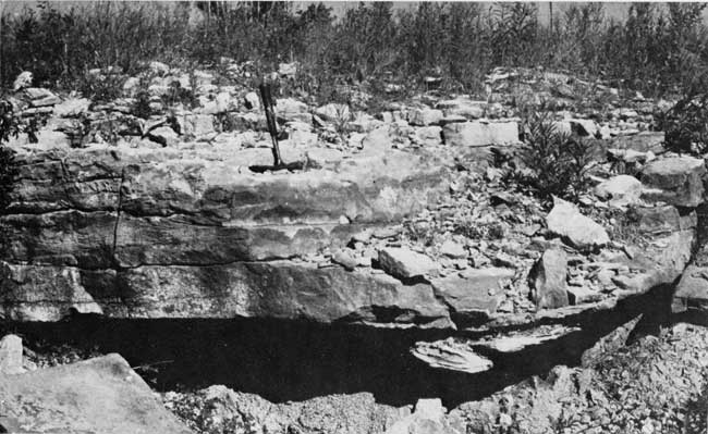
Figure 10--Conglomeratic coarse quartz sandstone that characterizes base of South Bend Member in many places; pebbles here are mainly calcilutite (white) and shale (gray). End of hammer in picture is 12 cm long. Blocks along road south of ctr W line SW 36-32-14.
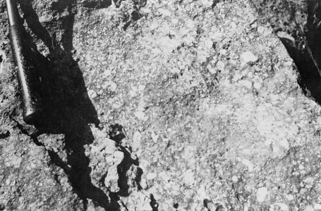
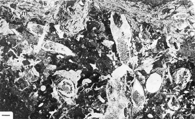
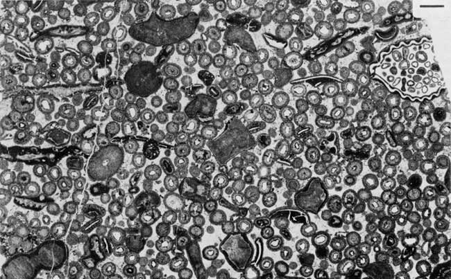
Figure 11--Thin section of conglomeratic coarse quartz sandstone characterizing base of South Bend Member; pebbles here include calcilutite (cl), siltstone (s), shale (sh), muddy sandstone (ms) and chert (ch). Also present are fragments of bryozoans, echinoderms, molluscs, etc. Scale in lower right is 1 mm long. From exposure near NW cor 31-34-14.
The lower contact of the South Bend is variable. It is sharp where the coarse-grained limy conglomeratic sandstone overlies shale, such as along U.S. Rte. 75 southwest of Wayside, but seems less abrupt and locally gradational where the South Bend overlies several feet of sandstone such as in exposures along U.S. Rte. 160 and around parts of Timber Hill (Fig. 9). Sandstone underlying the South Bend is reddish-brown, friable, much less calcareous, and in zones is markedly cross-bedded. It is generally distinct from the duller brown to yellowish, harder, calcareous, often fossiliferous, oolitic and/or conglomeratic sandstone marking the base of the South Bend. Quartz grains tend to be much coarser in the South Bend averaging about 0.3 to 0.5 mm and frequently exceeding 1 mm in size (Fig. 11) compared to an average of about 0.1 to 0.2 mm, rarely exceeding 0.4 mm in sandstone immediately below.
The two-fold subdivision characteristic of the South Bend is not observed in all exposures. For example, in the eastward facing line of outcrop north of Wayside (Plate 1), mainly the basal coarse fossiliferous and/or conglomeratic sandstone is apparent at the summit of a minor, only locally developed escarpment, presumably because the limestone is eroded back and covered by soil on the dip slope. Likewise, the upper limestone portion is exposed more often where the outcrop is cut into the dip slope such as northwest and southwest of Wayside. In the region between Wayside and Havana and along the Coon Creek watershed, the upper 1 foot or so of yellowish-weathering calcilutitic limestone carries a biota dominated by cylindrical and beaded calcisponges and including bryozoans, echinoderms, and brachiopods, with largely recrystalized algal?-foraminiferal encrustations around larger grains; it thus resembles markedly the Captain Creek Member at the base of the formation.
The outcrop trace of the South Bend Member, which generally follows the west side of the broad Stanton outcrop belt through most of the algal-mound facies belt, swings eastward around Timber Hill south of the Elk River (Plate 1) where the two thick underlying limestone members thin southward and are replaced by shale. Farther south, the South Bend swings westward again around the thick underlying Onion Creek sandstone body in the Rock Lake Member, then trends to the south-southeast as this sandstone thins just cast of Wayside. Southward, more thick sandstones enter the Stanton interval, and the South Bend outcrop once more swings southwestward leaving only a few outliers east of the main trend. Most outliers are capped by younger sandstones. One, however (in SW-SE-NW 19-34-14; Fig. 12), lies upon the west slope of an underlying sandstone body that forms hills eastward nearly as high as those formed by overlying sandstones to the south-southwest. These similarities in elevation had caused portions of the underlying sandstone to be mapped previously as a post-Stanton unit.
Figure 12--South Bend Member with prominent conglomeratic quartz sandstone in lower part (particularly in ledge above hammer) overlying unfossiliferous, finer-grained quartz sandstone (foreground) of Rock Lake Member which rises eastward to form hills mapped previously as Douglas Group. Creek bed in SW-SE-NW 19-34-14.
Approaching the Oklahoma border, much of the outcrop trace of the South Bend is covered by alluvium in the valley of Little Caney River. On the west side of the valley in the southwestern corner of Montgomery County, however, about 1 foot of coarse sandy South Bend Limestone, containing shale pebbles, crinoid debris and brachiopods, was traced from Kansas (SW-NW-SW 14-35-13) into Oklahoma.
Eudora and Rock Lake Shale Members--Inasmuch as the two shale members of the Stanton Formation are separated by the Stoner Limestone Member, they join to form one continuous terrigenous detrital unit (Fig. 13) for a short distance south of the pinchout of the Stoner in section 23, T. 32 S., R. 14 E. Certain limestone beds and a quartz siltstone bed that appear between the Captain Creek and South Bend Members were used to separate the Eudora and Rock Lake in central and southern Montgomery County by Wilson (1957a) and this practice is followed herein with the Timber Hill, Rutland, and Bolton beds. Nevertheless, it must be recognized that, because these beds first appear above the level of the main mass of the Stoner, then occur at slightly different stratigraphic levels southward, this boundary between the two shale members takes on different time values from place to place (Fig. 4). Where these beds are absent, the entire detrital interval between the Captain Creek (or Tyro) and the South Bend is referred to as Eudora-Rock Lake. Although shales are poorly exposed and were not emphasized in this study, some brief statements can be made concerning the nature of the two shale members.
Figure 13--Part of shale sequence dominating Stanton Formation in terrigenous detrital facies belt just south of algal-mound facies belt, showing mostly top of Eudora Member: person standing in lower left marks position of molluscan fauna; person seated marks position of diverse fauna; person above stands on position of Timber Hill siltstone bed which lenses in to left in several tens of feet; brush-covered slope above is shale of Rock Lake Member, and fence line at top rests on featheredge of Onion Creek sandstone body below South Bend Member. Roadcut on north side of U.S. Rte. 160 just north of ctr W line NW 36-32-14, about 6 miles west of Independence. (See also Fig. 4, 5, meas. sec. 14A.)
The Eudora Member ranges from about 30 feet thick beneath the south end of the Stoner in section 23 (Fig. 4, est. sec. 8) to 70 or 75 feet above thinned Captain Creek southward in Walker Mound and near the roadcut on the north side of U.S. Rte. 160 (Fig. 4, 5, est. secs. 14A, 15). In these thicker sections the Eudora is capped by a quartz siltstone (Timber Hill bed) which overlies shale that probably is equivalent to the top of the Stoner on the north prong of Timber Hill, so that much of the upper portion of the thicker Eudora shale sequence represents the southward gradation of the Stoner Limestone (Fig. 4). To the south, the Eudora thins southward from 40 feet to 18 feet thick beneath the Bolton bed. South of the disappearance of the Bolton bed, the Eudora is inseparable from the overlying Rock Lake Member. Most of the thicker Eudora in Townships 32 and 33 south is shale, but at least 10 feet of rippled, thin to medium-bedded sandstone appears at the top, 2 miles southwest of Bolton (NE 35-33-14). Brown sandstone recurs southward near this horizon in the Eudora-Rock Lake interval, not far above the Tyro oolite bed, and caps most of the east-facing escarpment in Townships 34 and 35 south.
Marking the base of the Eudora, about 1 to 2 feet of black fissile shale, locally with phosphorite nodules, has been observed above thin Captain Creek at Walker Mound, in a drillhole at the U.S. 160 roadcut (Wilson, 1957a, p. 45), in drillhole D, 3 miles to the west-northwest (Fig. 4, 5, meas. secs. 15, 14A, 10 respectively), southwest of Bolton (inferred by Wilson, 1957a, p. 14), above the Tyro oolite bed in the road (along S line NE SW 6-34-15) west of the hill west of Jefferson, and above the westernmost Tyro exposure along Hafer Run (Wilson, 1957a, p. 14). Furthermore, about 1 to 2 feet of dark gray, more easily disaggregated, clayey shale overlies the Tyro oolite at the Tyro Quarry (NW-SW-SE 30-34-15). Conodont faunas recovered from this and other exposures, presently under study by R. H. Wood, strongly suggest equivalence of this dark gray shale and the black shales at the base of the Eudora elsewhere in Montgomery County. This apparently extensive horizon of black to dark gray shale forms the basis of correlation of the lower Stanton throughout this region.
Gray to brown shales higher in the Eudora tend to be more noticeably fossiliferous than do higher levels of the Stanton. The fauna generally is dominated by molluscs, particularly snails and clams, but locally carries ammonoids, nautiloids, brachiopods, and crinoids (Fig. 4, symbol m). The upper part of the Eudora, where it represents the southward gradation of the Stoner limestone across about 2 miles from northeast to southeast of Timber Hill (Plate 1), is characterized by a rich, diverse fauna (Fig. 4, symbol f) dominated by fenestellid bryozoans, brachiopods, echinoderms, and, locally, sponges and large ramose bryozoans, which distinguish it from the mollusc-dominated fauna occurring below it. Both faunas can be observed in the U.S. Rte. 160 roadcut (Fig. 4, meas. sec. 14A; Fig. 13).
The Rock Lake Member thickens from a few feet of sandy shale (or missing entirely) above thicker portions of the Stoner mound southward to 10 to 12 feet above the siltstone overlying the Eudora along the east side of Timber Hill, then thickens further to 35 feet westward along U.S. Rte. 160 (Fig. 5). In this region it is largely unfossiliferous, silty, tan to gray shale with scattered earthy calcareous nodules, and includes from less than 1 to nearly 20 feet westward of friable, reddish-brown, unfossiliferous, cross-bedded to even-bedded quartz sandstone (part of the Onion Creek body) at the top, which locally seems transitional upward to the South Bend Member. Much of the westward thickening along U.S. Rte. 160 is in the sandstone at the top, but the underlying shale also increases westward from 10 or 12 feet in the east to 17 feet at Coon Creek and 26 feet in drillhole D (Fig. 5). Complementarily, the underlying Eudora thins westward from 70 or 75 feet southeast of Timber Hill to 40 feet in drillhole D to maintain a relatively constant interval for the entire Stanton in this region (Fig. 5). Southward, the Rock Lake encompasses much greater amounts of quartz sandstone and attains about 100 feet in thickness in the vicinity of Onion Creek. South of Onion Creek several calcareous zones, from oolitic sandstones to fossiliferous horizons and stromatolites, appear in the Rock Lake. Several of these seem traceable and are described further in a later section.
South of the disappearance of the Bolton bed, the Rock Lake is inseparable from the underlying Eudora. The southward thinning of the Eudora beneath the Bolton bed combined with the position of the two major calcareous zones in the Rock Lake (Fig. 4), however, suggests that the great majority, perhaps as much as the upper seven-eighths, of the Eudora-Rock Lake interval of southern Montgomery County consists of strata equivalent to the Rock Lake Member. Thickness of the entire interval is at least 150 feet and may reach as much as 200 feet in the vicinity of Cheyenne Creek, 3 miles northeast of Caney, where 150 feet of relief occurs in strata exposed somewhere between the Tyro and the South Bend in section 33, T. 34 S., R. 14 E. Throughout this region, thin-bedded to massive, gray to brown sandstone, locally with shale pebbles, dominates the Eudora-Rock Lake; certain delineated sandstone bodies are described briefly in a later section. Shale is sandy and subordinate, at least in exposures. Although the top of the Rock Lake is typically sandstone, several feet of shale underlie the South Bend Member along U.S. Rte. 75 for at least 2 miles southwest of Wayside.
Beds
Three beds of limestone and one of quartz siltstone are sufficiently distinct that they can be traced over several miles of outcrop with enough confidence to warrant naming them for ready reference. On account of the multitude of formal member names already applied to more extensive Pennsylvanian rock units in Kansas, I propose naming these new units in the southern end of the Stanton formation informally as beds, using the names Timber Hill, Rutland, Bolton, and Tyro from local geographic features. The former three beds have previously been regarded as Stoner (even though the Timber Hill is a siltstone), whereas the latter is correlated with the Captain Creek. In addition, other limestones or limy horizons mainly within the Rock Lake are either more local in occurrence or less definitely traceable, and thus are only briefly discussed without being geographically named. Finally, several sandstone bodies in the Rock Lake Member and Eudora-Rock Lake interval are roughly delineated, and one is given the informal name Onion Creek, pending more detailed work.
Timber Hill siltstone bed--Separating shale of the Rock Lake Member from shale of the underlying Eudora in the southern half of T. 32 S., is a thin bed of tan-weathering, light-gray quartz siltstone ranging from 2 to 4 feet thick. It is well exposed in cuts along the east side of Timber Hill, from which it is named, and the roadcut near center W line NW 25, T. 32 S., R. 14 E. is chosen as type section. The siltstone lenses out abruptly eastward, at least locally, within the U.S. 160 roadcut in SE-NE-NE 35-32-14. Here it overlies shale containing the diverse bryozoan-brachiopod-dominated assemblage, which occurs northward above the pinchout of the Stoner Member in section 23 (Fig. 4, meas. sec. 14A, 9). Westward, the Timber Hill siltstone is exposed along Coon Creek at the U.S. Rte. 160 highway bridge (Fig. 5, meas. sec. A). Southward, it occurs near the top of the north slope of the hill just north of ctr. E line SE 35-32-14, where it is overlain by the north end of the Rutland limestone bed and underlain by shale containing the diverse bryozoan-brachiopod fauna (Fig. 4, meas. sec. 14B). Eastward it is eroded away, but apparently occurs in an outlier as the capping siltstone ledge, 5 feet thick, on top of Walker mound (Fig. 5, est. sec. 15).
Lithologically, the Timber Hill is wavy thin-bedded to massive hard quartz siltstone with grains ranging from 0.03 to 0.12 mm and averaging about 0.05 to 0.06 mm in size. Muscovite is a subordinate constituent; matrix is sparry calcite. Irregular thin shaly partings separate the siltstone layers in some places. Where well exposed, contacts with both overlying and underlying shales seem conformable and gradational.
The Timber Hill bed so far has proved to be poorly fossiliferous. On top of Walker Mound, however, it contains rare pinnid and nuculid clams, gastropods, and the brachipod Linoproductus; a thin section from the type exposure reveals small pelecypod and rare echinoderm fragments.
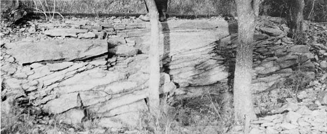
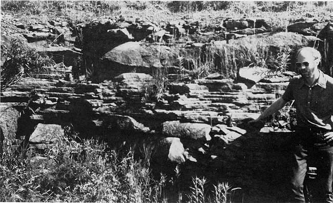
Rutland limestone bed--The first limestone to appear between the Captain Creek and South Bend Member south of the Stoner pinchout (Fig. 4) is a calcarenite bed named from the Township of Rutland. The main portion of known outcrop is in the southern halves of sections 35 and 36, T. 32 S., R. 14 E. and adjacent portions of section 1 and 2 in T. 33 S. (Plate 1). The most easily accessible exposure, designated the type section, is an old quarried ledge just south of the driveway in the northeast corner of section 2, T. 33 S., R. 14 E. (Fig. 14; Fig. 4, est. sec. 16). An outlier is known in the northeast corner of section 12, T. 33 S., R. 14 E., and another is inferred from scattered blocks near the southeastern corner of the same section.
Figure 14--Rutland bed at type section showing well developed cross-bedding dipping to north or northwest. Quarried ledge in NE cor 2-33-14.
The north end of the Rutland bed (near ctr. E line SE 35-32-14; Fig. 4, meas. sec. 14B) lies upon the Timber Hill siltstone bed, which overlies upper-Stoner-equivalent Eudora shale and separates the Rock Lake from Eudora along the east side of Timber Hill. Thus the Rutland bed not only is separated from the Stoner laterally along outcrop by a little over 2 miles of shale and siltstone, but also it overlies the siltstone that lies above the fossiliferous shale that overlies the Stoner pinchout (Fig. 4). These relations suggest that the Rutland bed is stratigraphically higher than most, if not all of the Stoner Member.
Thickness of the Rutland bed ranges from about 1 foot at its north end to at least 8 feet in its westernmost known exposure in the farmyard in NW-NE 2-33-14. Where well exposed, the unit exhibits large-scale cross-bedding (Fig. 14). It seems variable in thickness from place to place and perhaps is lenticular in nature within its outcrop extent, which may account for its spotty distribution.
Lithologically, the Rutland is a tannish to dull orangish-brown, coarse-grained bioclastic calcarenite with darker oatmeal-like plates of algae conspicuous over much of the weathered surface. Most skeletal grains are fragmental, and many are relatively well abraded. Small ooids (generally 0.2 to 0.5 mm) are scattered through the rock in the more northern outcrop and form an appreciable proportion of thin layers of the rock in the southeastern outliers. Oolitic nuclei are mainly small skeletal fragments, nondescript carbonate grains, and less commonly quartz. Small 1 to 2 mm calcilutitic intraclasts occur scattered throughout the rock, and only a few of the larger of these display osagia-type internal structure. Matrix is generally fine-grained to coarse-grained calcite spar with substantial replacement by small strained blocky crystals of dolomite.
Red and green algae constitute the most conspicuous and perhaps the most numerous elements of the biota (Fig. 15). Red algae consist mainly of fragments of Archaeolithophyllum with internal structure often exquisitely preserved, but include one fragment of a solenoporid identified as Parachaetetes (Heckel, 1975). Green algae are represented by fragments of the dasyclad Epimastopora and nondescript sparry grains, which probably are phylloid codiaceans that lack preserved internal structure. Invertebrate material comprises a diverse assemblage of echinoderm debris (including crinoid calyces and a possible sieve plate), fenestellid and rhomboporid bryozoans, mollusc and brachiopod fragments, scattered fusulinids and other foraminifers, small calcisponges, and small corals.
Figure 15--Thin section of Rutland bed showing fragmented and fairly well abraded grains of algae, including well preserved red Archaeolithophyllum (A) and dasyclad Epimastopora (E); most lighter grains are poorly preserved Archaeolithophyllum; other grains include several types of bryozoans, echinoderms, fusulinids, mollusc and brachiopod fragments, and ooids; matrix is spar that is largely replaced by small Fe-stained crystals of dolomite. Scale in lower right is 1 mm long. From ledge in farm yard in NW-NE 2-33-14.
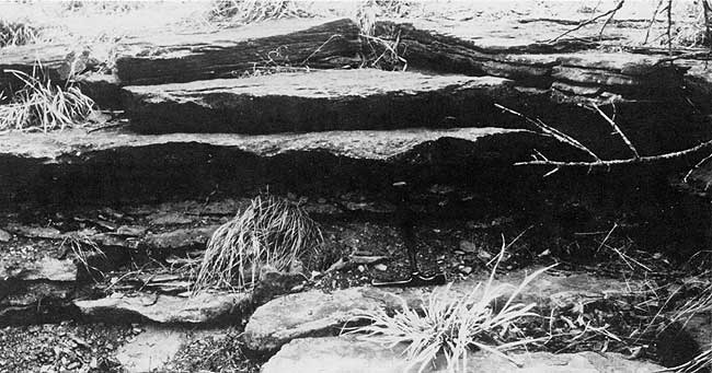
Bolton limestone bed--About 1.5 miles south of the disappearance of the Rutland bed, another bed of calcarenite, the Bolton bed, appears. It crops out across an arc of about 4 miles midway up the irregular low escarpment capped by higher sandstones west and south of the settlement of Bolton, from which it is named (Plate 1). The type section is chosen in the Santa Fe railroad cut about 2 miles southwest of Bolton (just N of ctr. S half NW-NW 36-33-14) where the bed is well exposed along with immediately adjacent strata (Fig. 16). Other easily accessible good exposures occur in roadcuts along the driveway in SE-SE-SW 24-33-14; along the road in SE-SW-SE 2633-14; and especially along the paved highways at S line SW-SW-SW 31-33-15, and W line SW-NW-SW 6-34-15.
Figure 16--Bolton bed at type section on north side of railroad cut near ctr S half NW-NW 36-33-14, with overlying Rock Lake shale and ledge of sandstone carrying shale pebbles exposed above shoulder level.
The northeast end of the Bolton bed (in SE-SW-NW 24-33-14, just north of the small pond) is 1.5 miles and 2.5 miles south of the southernmost known loose blocks and in-place exposures, respectively, of the Rutland bed in section 12 of the same township. No exposure of limestone was found, despite a search, in the nose of escarpment extending from section 14 into section 13 (Plate 1). Thus the Bolton bed is not connected along outcrop with the Rutland bed. Although the possibility exists of connection in the subsurface, some evidence suggests that the Bolton bed lies at a slightly lower stratigraphic horizon than the Rutland bed. The Rutland lies about 45 to 65 feet above the Captain Creek whereas the Bolton lies about 20 to 40 feet above the Captain Creek in the northern 3 miles of outcrop closest to the Rutland outcrop. Most of these figures are only estimates from topographic maps allowing for regional dip, however, and may not be accurate enough for a definite determination of horizon. The limy horizon exposed near the top of the small hill in NW-SE 13-33-14 about 30 to 40 feet above the Captain Creek and nearly midway between the limiting Rutland and Bolton exposures is mainly fossiliferous quartz siltstone with a lens of stromatolite, unlike the rock type of either of the two named beds. Furthermore, the northeasternmost exposure of the Bolton bed is a lenticular layer less than 1 foot thick that appears to lens out northward on outcrop; it is overlain by 2 feet of shale that is capped by about 0.2 feet of similarly lenticular oolitic limestone; these are relations that would be expected at the limit of a limestone unit. Elevations suggest that the ledge of skeletal-oolitic calcarenite in the bed of Onion Creek near W line NW-NW 23-33-14 is the northwesternmost known exposure of the Bolton bed.
Thickness of the Bolton bed ranges generally between 1 and 2 feet and attains 4.5 feet near the south end (SW-NW-SW 6-34-15), where 1 foot of shale occurs in the middle. Thickness is quite variable in short distances along outcrop, as is shown near the base of the north side of the hill northeast of Wayside (NE 35-33-14), where the bed thickens in a short distance from less than 2 up to 3 feet in a sort of megaripple form. Nearby, it apparently thins to zero inasmuch as the bed was not found at the expected elevation in the sandy sequence exposed just to the south between the railroad and U.S. Rte. 75 (SE-NE 35-33-14). Thus, it is possible that the Bolton bed consists of a series of closely spaced lenses, some of which might be at slightly different levels as suggested by the shale layers between limestone ledges at the north and south ends. Nevertheless, the lithologic character of the exposures is similar enough across a well-defined line of outcrop to treat these limestones as a named unit.
Lithologically, the Bolton bed is a yellowish-orange to yellowish-gray weathering, dominantly skeletal calcarenite in which several kinds of invertebrates are conspicuous on weathered surface. Petrographically, limestone in the Bolton ranges from skeletal calcarenite to mixed skeletal-oolite calcarenite in which many skeletal pieces are not oolitically coated. Skeletal pieces appear less fragmented and less abraded (Fig. 17) than those in the Rutland bed (Fig. 15). Scattered osagia-like coatings (see below) range from very thin around some smaller grains up to 0.5 and 1.0 mm thick around certain larger skeletal grains. Very few calcilutitic intraclasts without osagia structure were noted. Ooids are concentrated in certain layers; their sizes range generally from about 0.4 to 0.8 mm with coatings ranging from superficial to substantial around all sizes of nuclei, which include quartz grains as well as skeletal fragments. Quartz sand is scattered throughout the bed but is especially abundant in samples from both its north and south ends which suggests that the unit may grade laterally into sandstone. The matrix to the grains throughout the Bolton bed is mainly sparry calcite cement, although limonitic mud is apparent in places.
Figure 17--Thin section of Bolton bed showing relatively unfragmented and unabraded skeletal material consisting of a diverse group of invertebrates, including most conspicuously, several types of bryozoans, brachiopods, and mollusc and echinoderm debris; dark rims on some grains are osagia-like micritic coatings containing tiny encrusting foraminifers; ooids also are present. Scale in lower left is 1 mm long. From lower ledge exposed in roadcut along W line NW-SW 6-34-15.
The osagia-like coatings consist of layers of micrite that contain zones of tiny encrusting foraminifers. The micrite layers supposedly result from blue-green algae (Henbest, 1963, p. 35), but no diagnostic blue-green algal structure is preserved in Stanton specimens. Only a few preserved algae represented by fragments of red Archaeolithophyllum were noted in the Bolton bed. A diverse group of invertebrates dominates the biota (Fig. 17) and includes echinoderm pieces, fenestellid, rhomboporid, and fistuliporid bryozoans, brachiopods, less commonly snails, ostracodes, nonfusulinid foraminifers, calcisponges, and rare cephalopods and trilobite pieces.
Tyro oolite bed--The bed of oolite that can be traced southward at least 9 miles from the north end of T. 34 S. across the border into Oklahoma is named from the village of Tyro on U.S. Rte. 166 where it crosses the outcrop trace (Plate 1). The Tyro oolite occurs at or near the top of a relatively continuous escarpment from Tyro north and is encountered as an outlier about midway up the irregular mass of hills to the southeast in T. 35 S., R. 15 E. [Note: This name was first mentioned by Strimple and Cocke (1969).] Southwest of Tyro, the outcrop descends to the plain at the base of the escarpment and was traced across the Oklahoma border just west of the southeast corner of section 15, T. 35 S., R. 14 E. Reconnaissance in Oklahoma indicates that the southeastern outlier of the Tyro crops out around the remainder of the hills in the north part of T. 29 N., R. 14 E., and that the main trend extends southwestward toward an exposure on the road along the west line NW 27-19-13; this is a small outlier according to Oakes (1940a, plate 1) and is the southernmost exposure of Tyro presently known. The type section is chosen in the abandoned quarry northeast of Tyro, west of Stony Point (in NW-SW-SE 30-34-15). The only good exposures easily accessible by road are near the ctr. E line NE 7-35-15, and the state border locality near the SE corner 15-35-14. Other good but less accessible exposures include the top of the hill west of Jefferson at the juncture of sections 5, 6, 7, and 8, T. 34 S., R. 15 E.; near the crest of the hill northwest of Fawn Creek Cemetery in SE 19-34-15 (Fig. 18); along the railroad tracks just east of Tyro near ctr. N line, NW 6-35-15; and in an inlier west of Tyro in the west bank of Hafer Run near ctr. NE-NE 4-35-14.
Figure 18--Tyro oolite bed exposed on southeast side of hill northwest of Fawn Creek Cemetery (NW-SE-SE 19-34-15) showing consistently westward to southwestward dipping crossbeds emphasized by thin zones of echinoderm fragments (white spots); similar consistent southwestward dips of cross-beds were measured by Harbaugh ( 1962, p. 58) and illustrated by Hamblin (1969, p. 8) from type section of Tyro bed in Tyro Quarry, 1 mile to south.
The Tyro is traced west-northwestward from the hill west of Jefferson (SW corner 5-34-15) to a poor exposure in the road ditch along west line NW-SW 6-34-15. Because black shale typical of the base of the Eudora farther north overlies the Tyro in the road exposure (S line NE SW 6-34-15) in between, the Tyro seems equivalent to the Captain Creek Member (which disappears southward about 1.2 miles to the north). Nevertheless, stratal continuity is not proven, and lithologic transition between the two units is unknown. Thus, the Tyro bed is a distinct lithologic entity that marks the base of the Stanton in the southern two townships in Kansas and the northernmost township in Oklahoma.
The Tyro overlies a substantial thickness of gray shale that constitutes the Lane-Vilas Formation. Layers of sandstone appear just below the Tyro in T. 35 S., and are best exposed in the outlier hills southeast of Tyro. The Lane-Vilas locally carries a mollusc-dominated fauna including snails, nuculid, pectinid and other clams, leiorhynchid brachiopods and occasional crinoids and cephalopods, which resembles both the fauna of the stratigraphically higher Eudora to the north and that of much of the Wann Formation farther south in Oklahoma.
The elevation of the west end of the Tyro inlier along Hafer Run (795 feet above sea level) is extensively exposed along Cheyenne Creek a little over one mile along strike to the north (Plate 1), but no oolite was found; this suggests either that the Tyro lenses out to the northwest between the two localities, or that it dips more northerly and perhaps more steeply in this local area. It is known that the Tyro dips more steeply westward across section 6-34-15, at nearly 70 feet per mile (from top at 905 feet in SE corner to 837 feet along W line; Appendix 1, est. secs. 31, 32) and across section 7-34-15 at about 50 feet per mile (from 880 feet to 850 feet in 0.6 mile; see Appendix 1, est. secs. 35, 36), and perhaps also farther south (see note in Appendix 1, est. sec. 39).
Thickness of the Tyro ranges from about 1 or 2 feet in several places to as much as 15 feet at the type section where the base is not exposed. Thickness can be observed to vary in an undulatory manner by a foot or so in a short distance along a good exposure, imparting to the Tyro the sort of megaripple form that occurs in the Bolton bed. Also, thinning of the Tyro eastward across NW-NE 13-35-14 to disappearance in exposures along the north-south road indicates that the Tyro is locally lenticular within its outcrop belt.
Lithologically, the Tyro is a cross-bedded oolite everywhere with local zones carrying substantial abraded fossil debris (Fig. 18). At the three localities where measurements were made, cross-beds dip consistently to the west to southwest (Tyro Quarry; hill west of Jefferson; hill northwest of Fawn Creek Cemetery). In various exposures the rock weathers yellowish to orangish-brown or light gray. Most distinctively, in the Tyro Quarry it weathers light gray and is marked by rusty-brown "leopard" spots and "tiger" stripes resulting from oxidation of localized patches and streaks of ferroan dolomite replacement of whole ooids.
Ooids range from about 0.3 to 0.5 mm in size with relatively thin coatings around mainly quartz nuclei in the north, to 0.6 to 0.9 mm in size with relatively thick coatings around both quartz and carbonate nuclei around Tyro. When present, larger skeletal grains (up to 2 and 3 mm) typically have a thinner oolitic coating (Fig. 19). In places toward the south, smaller ooids are interbedded with larger ones. At the Hafer Run exposure, ooids average about 1.2 mm in size with thick coatings around nuclei of quartz and small carbonate grains. Intraclasts are rare in the Tyro, but a calcareous quartz sandstone pebble several mm in diameter and with a thin osagia-like coating was collected in the oolite near the north end. Matrix to the ooids is almost entirely spar throughout the bed. Both interstitial calcite spar and particularly the ooids have undergone a wide variety of patterns of diagenetic replacement, especially by ferroan dolomite.
Figure 19--Thin section of Tyro oolite bed showing both thickly coated small ooids, mainly with quartz nuclei (white spots), and more thinly coated large ooids nucleated around skeletal fragments (mainly echinoderm pieces, but also bryozoan and brachiopod fragments); shell of brachiopod in upper right became closed around ooids in earlier stage of development. Scale in upper right is 1 mm long. From hill northwest of Fawn Creek Cemetery, SE 19-34-15.
Skeletal material scattered through certain zones in the Tyro consists predominantly of echinoderm debris, with a number of bryozoan, brachiopod, and mollusc fragments. Whole fossils occur typically in shaly partings, and consist mainly of the above named groups.
Calcareous horizons in the Rock Lake Member--The occurrence of at least two higher levels of impure limestone above the Bolton bed within the Rock Lake Member is shown in the small hill north of U.S. Rte. 75, about 2 miles northeast of Wayside, near ctr. NE 35-33-14 (Plate 1; Fig. 4, meas. sec. 28). Here the Bolton bed is exposed several feet above creek level on the north side of the hill. About 24 feet above the Bolton bed is a one-foot layer of oolitic quartz sandstone. At the top of the hill, 16 to 20 feet higher, is a 4-foot thickness of fossiliferous oolitic quartz sandstone containing brachiopods, bryozoans, and shale pebbles. These limy horizons are referred to informally as the third and fourth oolitic zones, respectively, from their position above the lower oolitic horizons. Although lateral continuity of these poorly exposed calcareous horizons is only conjectural, similar rocks are found at approximately the right elevations at enough places in Townships 34 and 35S and southernmost T. 33 S. that they can be joined locally into probable outcrop traces shown by broken lines on Plate 1 and Figure 4.
The most laterally traceable exposures are assigned on the basis of elevations to the third oolitic zone. These consist of sporadically fossiliferous oolitic sandstones, locally with mud pebbles, around the watershed of Cheyenne Creek in south to east-central T. 34 S., R. 14 E. Also assigned to the third zone are outcrops of oolitic and shelly sandstones 10 to 25 feet above the Bolton bed in adjacent sections 1 and 6, T. 34 S., Ranges 14 and 15 E., and 10 feet above the Bolton in SW 25-33-14. Two outcrops of skeletal to oolitic sandstone with mud pebbles in section 4, T. 35 S., R. 14 E. are assigned with caution to the third zone because they lie perhaps as little as 15 feet stratigraphically above the exposure of Tyro oolite along Hafer Run in the northeast corner of section 4; their horizon is close to that of the Bolton bed, but is 6.5 miles southwest of the nearest known Bolton exposure.
Exposures assigned to the fourth oolitic zone are locally more limy, but generally less laterally traceable than those below. The most extensive horizon is that of shelly oolite to fossiliferous oolitic sandstone not far below the South Bend in the western half of T. 35 S., R. 14 E., east of Caney; the gastropod-dominated sandstone in section 16 of this township may also belong in this horizon. Exposures of fossiliferous oolite with quartz nuclei northeast of Wayside about 1 mile west of the hill capped by the type exposure of the fourth zone were probably continuous with it prior to modern erosion. Isolated outcrops of oolitic skeletal calcarenite in NW corner 12-34-14 and of quite pure oolite on the S line, SW 17 of the same township are included because of appropriate elevations. Definitely above the third zone, but less certainly assigned to the fourth, are two layers of brachiopod-dominated sandstones north and west of Tyro (W line NW 30-34-15; NW-SW 34-34-14). Elevations would suggest inclusion also of the layer of fossiliferous oolitic sandstone near the top of the knob near ctr. E half 12-35-14 south of Tyro, even though the third zone then would be absent throughout this area.
It is possible that some of these limy horizons in the Eudora-Rock Lake interval occur outside the two zones that are delineated in the hill north of U.S. Rte. 75 northeast of Wayside. In any case, all horizons are lithologically unlike the quartz-free skeletal calcarenitic Rutland bed to the north, which is separated from the northernmost reported exposures (Fig. 4, meas. sec. 25) along outcrop by at least 2 miles of noncalcareous sandstone and shale.
A variety of oolitic and skeletal quartz sandstones are the most common rock types in the limy horizons of the Eudora-Rock Lake interval of southern Montgomery County. In addition, three types of purer limestone in this interval: oolite, stromatolite, and sorted-abraded skeletal calcarenite, are worthy of note despite their apparently quite limited outcrop extent.
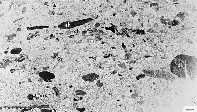
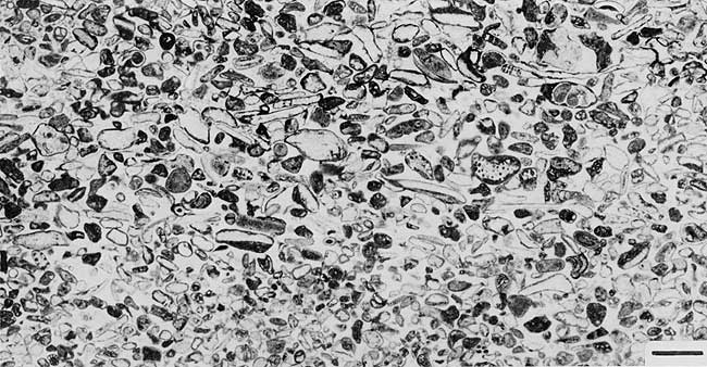
Slightly oolitic quartz sandstones dominate the horizons mapped as the third oolitic zone, particularly around the watershed of Cheyenne Creek. Petrographically, these rocks range from variants in which most nuclei are only slightly coated to those composed of a mixture of both uncoated quartz grains and thinly to thickly coated ooids (Fig. 20), sometimes segregated into discrete laminae. The thicker oolitic coatings often are replaced by several blocky, strained crystals of dolomite. Quartz grains range from about 0.1 to 0.3 mm and 0.2 to 0.6 mm in size in different samples, and seem fairly well sorted in any one sample. Ooids with quartz nuclei range generally from 0.2 to 0.4 mm in size. Although macrofossils are not common in these rocks, a number of quartz-size or larger grains consist of abraded skeletal debris, including ostracodes and pieces of echinoderms, brachiopods, molluscs, and occasionally bryozoans. Locally, shale pebbles up to 1 or 2 cm long are common (Fig. 20). The matrix to the grains is mostly clear calcite spar, often in crystals large enough (about 1 mm) to encompass several grains. This group of rocks is gradational into the next category.
Figure 20--Thin section of slightly oolitic quartz sandstone with shale pebbles, and containing enough small skeletal fragments (mostly mollusc and brachiopod, with some bryozoan and echinoderm) to consider rock as gradational to skeletal-oolitic quartz sandstone; scattered ooids range from thinly to thickly coated. Scale in upper left is 1 mm long. From 3rd oolitic zone of Eudora-Rock Lake interval exposed in road ditch near ctr W line 23-34-14.
Skeletal-oolitic quartz sandstones dominate the northern and southwestern portions of the horizons mapped as the fourth oolitic zone, and occur locally in the third oolitic zone. These rocks are characterized by the presence of a substantial number of large skeletal grains, some nearly whole, and by the presence of thin to thick oolitic coatings around nearly all quartz grains and many smaller skeletal grains (Fig. 21). These coatings exhibit both concentric and radial structure, but only minimal replacement by dolomite. Quartz is subordinate enough in some variants of this group that they approach lithologies characteristic of the Tyro and Bolton beds. Macrofossils consist mostly of fragments of echinoderms, brachiopods (including productid spines), and bryozoans (including rhomboporids, fenestellids, and rare fistuliporids); molluscan fragments, small snails, foraminifers (including rare fusulinids), ostracodes, and calcisponges are present in lesser numbers. Locally, some grains have osagia-type coatings. Generally, quartz grains range from 0.1 to 0.4 mm, and ooids range from 0.2 to 0.5 mm in diameter; skeletal debris is typically much coarser, in places exceeding 0.5 cm in thin-section cuts. As in the oolitic sandstones, most of the matrix is clear calcite spar in crystals large enough to encompass several small grains.
Figure 21--Thin section of skeletal-oolitic quartz sandstone showing thin to relatively thick coatings around all quartz grains and small skeletal fragments (mainly echinoderms, some brachiopods and foraminifers); macrofossils typically common in this rock type were not cut in this thin section. Scale in lower right is 1 mm long. From 4th oolitic zone of Rock Lake Member exposed at top of hill northeast of Wayside near ctr NE 35-33-14.
Skeletal quartz sandstones differ from the above group by containing mostly uncoated quartz grains and only greatly subordinate ooids. These rocks are generally found in layers of limited lateral extent, but assigned to the fourth zone on the basis of elevation. Quartz grains range from about 0.1 to 0.3 mm in size. Skeletal material includes fragments coarser than the quartz and also a large number of whole shells. Brachiopods, bryozoan (fenestellid, rhomboporid), and echoniderm pieces are common to the group in general. Whole brachiopods characterize beds in NW-SW 34-34-14 and in NW 30-34-15, whereas whole snails of several genera (including bellerophontids and probable Hypsolentoma, identified by E. Yochelson) dominate the horizon exposed near ctr. SE 16-35-14. Matrix ranges from mud and small calcite crystals in the gastropod-rich layer to large clear calcite crystals in one of the brachiopod-rich layers.
Oolite that is relatively pure forms the bed of the creek in SW SE 17-34-14. Although not traced laterally, this rock seems to lie in the fourth oolitic zone. Quartz grains 0.2 to 0.3 mm in diameter nucleate most of the ooids, which average about 0.6 to 0.7 mm in diameter. Most coatings exhibit several concentric layers within which fine radial structure is visible. Matrix is clear blocky calcite locally containing small (about 0.05 to 0.10 mm) micritic pellets resting in places upon the ooids.
Stromatolites are best known from exposures on a small tributary to Hafer Run in SW-SE-NE 4-35-14, and cannot be definitely assigned to a traceable zone. Two ledges of stromatolitic limestone, each several inches thick, crop out in a shaly sequence about 15 feet above the mud-pebble-rich skeletal-oolitic sandstone assigned with caution to the third zone (Fig. 4, est. sec. 43c). One ledge displays gently undulating stromatolitic laminae in a sequence several centimeters thick, starting on a relatively flat surface (Fig. 22A). The other ledge exhibits warty nodular to digitate protuberances of laminae several millimeters thick around nuclei of whole shells, including brachiopods, bryozoans, and small corals. Laminar microstructure in both growth forms is somewhat similar to that of the osagia coatings around grains in the Bolton bed. It consists of irregular thin zones of dark micrite alternating with thicker zones of small (0.05 to 0.20 mm long) subhemispherical cuts of encrusting agglutinated foraminifers that are composed of tiny quartz grains and that have interiors filled with lighter-colored mud (Fig. 22B); these foraminifers resemble Minammodytes of Henbest (1963). Larger (0.2 to 0.4 mm) subhemispherical, locally multichambered calcareous foraminifers with dense brownish skeletal material, probably Apterrinella (D. F. Toomey, pers. commun., 1973), augment the encrustation in places (Fig. 22B). Scattered quartz grains are incorporated into the lamination. Although no remains were detected, the dark micritic laminae are attributed to poorly calcified blue-green algae which leave visible remains of tiny tubules in certain encrusting fabrics elsewhere in Pennsylvanian limestones (but not in the Stanton, as far as known). Another stromatolitic mass containing encrusting foraminifers surrounds a group of small corals in an unassigned fossiliferous siltstone ledge on the side of the hill in NW-SE 13-33-14.
Figure 22--Thin section of stromatolite layer in Eudora-Rock Lake interval exposed in gully in SW-SE-NE 4-35-14 near Hafer Run. A. Low-magnification shot showing well-laminated appearance consisting of dark micrite alternating with lighter concentrations of encrusting foraminifers; spar-filled cavities break laminae in upper left. Scale in lower right is 1 mm long. B. High-magnification shot of small portion of lower right center of A showing individual encrusting foraminifers, mostly agglutinated Minammodytes (small white irregular semicircles usually surrounding light gray fillings) but with larger calcareous, dark-shelled, probable Apterrinella (A) in upper right. Scale in lower right is 0.1 mm long.

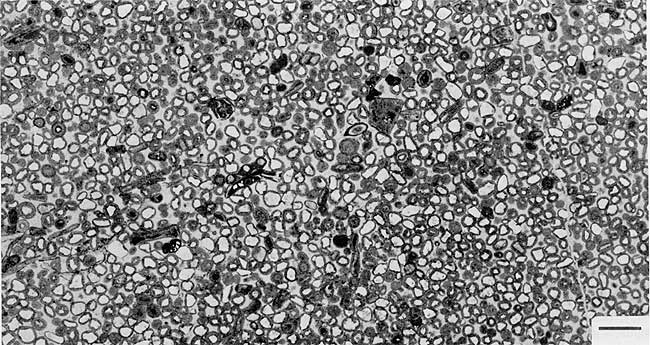
Sorted-abraded skeletal calcarenite constitutes a 0.3-foot ledge of finely graunlar limestone within the 10-foot sequence of shale in the Rock Lake exposed above the southern end of the Stoner Member along the road down the north prong of Timber Hill near ctr. NW 23-32-14 (Fig 4, meas. sec. 6). This ledge has not been found to trace laterally. It may lie at or near the horizon of the Rutland bed, but is separated from it along outcrop by shale that is well exposed at places for nearly 2 miles along the east side of Timber Hill. The rock consists almost entirely of fairly well rounded skeletal fragments, ranging from 0.2 to 1.2 mm in diameter (or length), in a matrix of relatively clear fine-grained calcite spar (Fig. 23); drusy rims are detectable on some grains. The grains are dominantly foraminifers (including encrusting types) and rounded blocky mosaics of calcite that may be recrystallized fragments of phyloid algal blades. Less abundant grains include echinoderm pieces, ostracode valves, and fragments of snails, clams, brachiopods, and dasyclad algae. Osagia-like and oolitic coatings occur on a few grains.
Figure 23--Thin section of sorted-abraded skeletal calcarenite layer within Rock Lake Shale Member in north prong of Timber Hill near ctr NW 23-32-14, showing lack of grains over a certain size and well-abraded nature of fragments derived from a wide variety of skeletal groups, including probable phylloid algae, foraminifers, echinoderms, molluscs and ostracodes. Scale in lower right is 1 mm long.
Sandstones in the Rock Lake Member--Although not studied in detail, a number of quartz sandstone bodies and facies were sufficiently delineated within the Rock Lake Member and Eudora-Rock Lake interval for some general observations on their occurrence and nature.
Along outcrop in T. 33 S., R. 14 E., a thick body of sandstone and shale occupies a large portion of the Rock Lake Member between the Bolton bed and South Bend Member (Plate 1; Fig. 4). It is informally termed the Onion Creek sandstone body from its extensive exposure in sections 14, 15, 22, and 23 along Onion Creek and its tributaries. Substantial sandstone first appears as low as the horizon of the Bolton bed, north and east of the house in NW-SW 24-33-14 (Fig. 4, between est. secs. 22 and 24), but southeastward about 0.5 mile, massive sandstone first appears only above what is apparently the northernmost extent of the fourth oolitic zone in a section measured by Newell in 1935 (Fig. 4, meas. sec. 25). Although the base of the sandstone is poorly exposed west of the eastern prongs of escarpment, about 100 feet of dominantly sandstone may be estimated using elevations from the sandstone ledge at 860 feet near the house in NW-SW 24, west-southwestward to the crest of the hill at 925 feet in NW-NW 26, adding 35 feet for regional dip. The Onion Creek body consists mainly of massive to bedded, friable, buff to reddish-brown quartz sandstone with cross-bedding locally conspicuous on the surface; shale occurs at places within the body. Quartz grains range from 0.1 to 0.4 mm and rarely exceed 0.5 mm in size. The Onion Creek body extends westward at least 3 miles through sections 29 and 30 where sandstone of similar nature is exposed below the South Bend in the inlier along Deer and Coon Creeks. It apparently extends northward as well, but thins to 20 feet or less and becomes restricted to the very top of the Rock Lake Member as the reddish-brown, cross-bedded to evenly bedded sandstone (Fig. 24) exposed just below the South Bend Limestone in the southern tributaries of Card Creek from northernmost T. 33 S. into the southern sections of T. 32 S. (Plate 1; Fig. 5). The southern end of the Onion Creek sandstone body is marked by gradation from more massive sandstone into thin-bedded sandstone alternating with shale and by reduction of the entire Rock Lake Member to perhaps 70 feet in sections 27 and 34 (T. 33 S., R. 14 E.) just northeast of Wayside.
Figure 24--Portion of northern extent of Onion Creek sandstone body (Rock Lake Member) showing even-bedded horizon that may represent beach or offshore bar environment. North side of U.S. Rte. 160 roadcut in SW SE 28-32-14 about 8 to 9 miles west of Independence.
Southward in townships 34 and 35 south, a number of sandstone masses are apparent in the Eudora-Rock Lake interval, but are less well delineated than the Onion Creek body. Two major facies types are recognized: 1) massive to thick-bedded sandstone, and 2) thin-bedded sandstone with intercalated shale.
1) Sandstones forming the topographic prominences in this region tend to be thick-bedded to massive, friable, and with cross-bedding visible on some surfaces, like the Onion Creek body. Color ranges from tan to brown and locally red. Three large masses primarily of this type lie northwest and southwest of Tyro (Plate 1), centered respectively in sections 23, 24, 25, and 26, T. 34 S., R. 14 E.; sections 20, 21, 22, 28, and 29, T. 34 S., R. 14 E.; and sections 1, 2, 3, 10, 11, and 12, T. 35 S., R. 14 E.; all three may be erosional remnants of the same larger body. Thicknesses of perhaps 50 to 80 feet can be estimated from elevations for the two northern masses. A total of 80 feet is suggested for the southern mass along the road separating the south halves of sections 10 and 11; the amount of covered shale included in these estimates is unknown. Although not field checked, the prominence in section 33, T. 34 S., R. 14 E. suggests that much of the 150 feet of relief there is resistant sandstone. Where the two northern masses face Cheyenne Creek, they lie above the third oolitic zone. Part of the eastern mass extends above the brachiopod-rich sandstone mapped as the fourth zone in 30-34-15. Away from Cheyenne Creek, the third oolitic zone is unknown around the eastern and southern masses, which suggests that this zone either has changed facies into, or has been cut out by, the massive sandstones to the southeast. A smaller sandstone body centered in the west half of section 7, T. 34 S., R. 15 E. above the Tyro oolite bed apparently replaces both the Bolton bed and the third oolitic zone southward.
Another small massive sandstone body forming the two high hills in sections 16 and 17, T. 35 S., R. 14 E. not only lies above shelly sandstone assigned to the fourth oolitic zone, but also reaches 160 feet higher than mapped South Bend in the base of the hill 2 miles to the northwest, yet no South Bend was found in a reconnaissance search of these hills. This suggests that this body is either 1) a Douglas Group sandstone which has cut out the South Bend in this region, or 2) a local thickening of a Stanton sandstone lens, the featheredge of which is found in the thin interval between the fourth oolitic zone and the South Bend in SE 6 and adjacent NE 7-35-14. The latter alternative is preferred because of similar situations to the north, for example N half sec. 30 T. 33 S., R. 14 E. and in sections 18, 19, and 20, T. 34 S., R. 14 E., where the South Bend ascends abruptly onto eastwardly thickening sandstones that lie within the Rock Lake (Fig. 6).
2) Thin-bedded sandstones and siltstones are known in the poorly exposed shale sequences that underlie many of the massive sandstones and crop out low on hill slopes or in stream valleys. These sandstone beds range from white and friable to tan or brown and ripple marked. All commonly contain shale pebbles, which are scarce, though present, in the more massive sandstones. Fossils are unknown.
A particularly distinctive type of thin-bedded sandstone facies consists of a rather regular interbedding of shale and very hard sandstone layers, each several inches thick and locally containing abundant mud pebbles. This facies is well exposed above and below the horizon of the third oolitic zone in roadcuts near the northwest and southwest corners of section 23, T. 34 S., R. 14 E. and just below the South Bend east of the northwest corner sec. 20 and near ctr. W half sec. 19, T. 34 S., R. 14 E. Grains in at least one layer consist mainly of quartz ranging from a little less than 0.1 to 0.3 mm, but include subordinate plagioclase and potassium feldspar and substantial muscovite. Most distinctively, although the toughness of these layers can lead one to consider them "quartzitic," the matrix is entirely clear calcite spar in immense crystals several millimeters to perhaps centimeters across, each encompassing multitudes of quartz sand grains.
Prev Page--Typical Limestone || Next Page--Oklahoma
Kansas Geological Survey, Geology
Placed on web Jan. 20, 2009; originally published May 1975.
Comments to webadmin@kgs.ku.edu
The URL for this page is http://www.kgs.ku.edu/Publications/Bulletins/210/04_detr.html