![]()
Prev Page--Detrital Facies Belt || Next Page--Southeastern Kansas
Implications to Stratigraphic Subdivision in Oklahoma
Tracing of members and beds of the Stanton Formation across Montgomery County, Kansas, to the Oklahoma border bears significantly on the stratigraphic subdivision utilized in the geologic map of adjacent Washington County in Oklahoma by Oakes (1940a). The following observations are based on the detailed mapping in Kansas along with limited reconnaissance south of the Oklahoma border. Verification of suggested relations of units farther south in Oklahoma awaits availability of accurate 7.5-minute topographic maps of Washington County.
Relationship of Stanton Units to Birch Creek Limestone in Northern Washington County
Oakes (1940a, p. 76, 86) regarded the Birch Creek Limestone as a single stratigraphic horizon. It is obvious from the present study, however, that the Birch Creek as mapped by Oakes (1940a, plate 1) in the northernmost tier of townships in Oklahoma (T. 29 N.) represents at least two different stratigraphic levels in the Stanton Formation: 1) the Tyro oolite bed, and 2) the South Bend Limestone Member.
The Tyro oolite has been traced across the border into mapped Birch Creek Limestone in Oklahoma both in the outlier hills in sections 15 and 16 of T. 29 N., R. 14 E. and along the main outcrop trend into NW 13, T. 29 N., R. 13 E. (Plate 1). I have collected weathered oolite characteristics of the Tyro from the Birch Creek outlier near the northwest corner of section 27, T. 29 N., R. 13 E. Oakes (1940a, p. 88) reports a very sandy oolite from the main line of his outcrop trace in section 21 about 1 mile to the northwest; this seems to resemble more closely the higher oolitic sandstone horizons in Eudora-Rock Lake interval. Thus it appears that all of the Birch Creek mapped by Oakes in T. 29 N., R. 14 E. and in at least the eastern and southeastern portions in R. 13 E. represent the Tyro oolite bed (as indicated with a dashed line on Plate 1). In addition, mapped Birch Creek in the western part of T. 29 N., R. 31 E. may represent one or more horizons above the Tyro, within the Eudora-Rock Lake interval of the Stanton.
The South Bend Limestone Member has been traced across the border into mapped Birch Creek in the northwest corner of section 13, T. 29 N., R. 12 E. (Plate 1). This line of Birch Creek outcrop is indicated to extend for a great distance southward along the line of hills west of Caney River. At several localities for a distance of about 35 miles to its type section in T. 24 N., Oakes (1940a, p. 88-90) describes the Birch Creek as a thin, brownish, fossiliferous, sandy limestone to limy sandstone, which seems similar to the South Bend of southernmost Montgomery County, Kansas. Assuming that this limestone horizon has been correctly traced, then the type Birch Creek Limestone correlates to the South Bend Limestone Member of the Stanton Formation in Kansas, as Oakes (1951) and O'Connor (1962, p. 155) have suggested. Nevertheless, evaluations that the Birch Creek represents more than one horizon west of the Caney River in Townships 25 and 26 N. (e.g. Tanner, 1956, p. 30; Strimple and Strimple, 1968) point up the necessity of field verification.
Of the outliers mapped as Birch Creek by Oakes (1940a, plate 1) in T. 28 N., R. 13 E., the limestone holding up eastern Twin Mound in section 35 is the small phylloid-algal buildup mentioned by Heckel and Cocke (1969, p. 1073) and regarded as a lens in the Wann Formation (see later section); the other outliers were not visited. Considering elevations obtained from the 30-minute Nowata Quadrangle (1914; with contour interval of 50 feet) along with the regional westerly dip of the strata, at least some of the outliers in T. 28 N., R. 13 E. may lie below the Birch Creek-South Bend horizon west of Caney Creek, and thus may occur lower within (or even below) the horizon of the Stanton Formation in Kansas.
Relationship of Stanton Units to Torpedo Sandstone
Oakes (1940a, p. 76) considered the Torpedo Sandstone to represent a unique stratigraphic horizon of variable thickness lying unconformably below the Birch Creek Limestone, with or without an intervening shale. Because the Birch Creek mapped by Oakes (1940a, Plate 1) represents at least two different stratigraphic horizons in northernmost Washington County (T. 29 N.), it is obvious that the Torpedo Sandstone mapped by Oakes in the same region represents at least two different horizons: 1) directly below the Tyro oolite in T. 29 N., R. 14 E. and the eastern half of T. 29 N., R. 13 E., and 2) above the Tyro oolite within the Eudora-Rock Lake interval in T. 29 N., R. 12 E. and probably also in parts of the western half of T. 29 N., R. 13 E. It seems likely that the Torpedo as mapped by Oakes represents measurably different stratigraphic levels southward into T. 28 N. as well.
Type Torpedo Sandstone occurs about 20 miles south of the Kansas-Oklahoma border west of Bartlesville, in T. 26 N., below Birch Creek Limestone that may be equivalent to the South Bend. Thus type Torpedo and its overlying shale are very likely equivalent to sandstones and shales occurring within the Eudora-Rock Lake interval in southern Montgomery County, Kansas. Oakes (1940a, p. 86) considered the Torpedo Sandstone to be "cut off" at the Kansas-Oklahoma border by a sub-Birch Creek unconformity because he mapped the sandstones lying above the Tyro bed in the northern part of T. 29 N., R. 13 E. (Plate 1) as post-Birch Creek, thus equivalent to the post-Stanton strata west of Caney River, when in fact they lie within the Eudora-Rock Lake interval of the Stanton Formation between the horizons of mapped "Birch Creek."
Relationship of Stanton Formation to Wann Formation (as Redefined)
The name Wann Formation was applied by Oakes (1940b, p. 276-277) to the substantial thickness of predominantly shaly strata above the Iola Limestone and below the Torpedo Sandstone, or Birch Creek Limestone where the Torpedo is absent (see also Oakes, 1940a, p. 67). Because the notoriously lenticular nature of sandstone bodies in this part of the sequence nearby in Kansas strongly suggests that both type Torpedo and other sandstones mapped as Torpedo by Oakes (in addition to those now definitely determined to lie below the Tyro oolite) are merely lenticular bodies within a clastic sequence, it is deemed advisable to redefine the top of the Wann Formation at a more consistent stratigraphic horizon.
Therefore I propose (1) that the top of the Wann Formation in Oklahoma be placed at the top of the "type" Birch Creek Limestone as mapped by Oakes along the main outcrop trace west of Caney River and (2) that the Birch Creek Limestone and Torpedo Sandstone be recognized as members within the Wann. [Note: A procedure close to this seems to have been utilized for the Geological Map of Oklahoma (1954) on which the Torpedo is mapped with the Wann without being listed as a separate formation in the explanation; this procedure was adopted by Strimple and Strimple (1968). The Birch Creek had been placed as a member marking the base of the overlying Barnsdall Formation by Oakes (1951), but is more appropriately included in the Wann if it is largely equivalent to the South Bend inasmuch as the Missourian-Virgilian boundary is now recognized at the top of the South Bend, and thus would be at the top of the Wann as herein redefined in Oklahoma.] (Although this proposal assumes lateral continuity of this part of the Birch Creek outcrop trace, which needs verification, it seems a better alternative than using the base of the mapped Torpedo, which is known at this time to lie at a minimum of two different stratigraphic horizons). Assuming that the type Birch Creek and the South Bend Member of the Stanton Formation at the Kansas-Oklahoma border are correlative, then the Wann Formation as redefined in Oklahoma is exactly equivalent to the sequence of six formations ranging from the Lane Shale up through the Stanton Limestone in Kansas (Fig. 25).
Figure 25--Stratigraphic nomenclature for upper Missourian units in eastern Kansas and adjacent portion of Oklahoma (modified from Oakes, 1940a, 1951; O'Connor, 1963; Zeller, ed., 1968): new suggestions involve Stanton and Wann Formations (lined obliquely in opposite directions) in Montgomery County, Kansas, and Washington and adjacent counties in Oklahoma. Formations and groups are in capital letters; members and beds are in small letters. THsb= Timber Hill siltstone bed. Asterisks mark approxiniate locations of type sections. Distances and thicknesses are not to scale. Note that Lansing Group is a meaningless unit south of disappearance of Plattsburg Limestone in Montgomery County, Kansas.
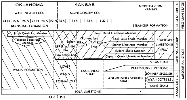
In addition to the Stanton, this sequence contains two older limestone formations (Wyandotte and Plattsburg) in northeastern Kansas. As these disappear southward and the adjacent shale formations coalesce, the combined shale sequence customarily is given a hyphenated name formed from the names of the highest and lowest separate shales northward. Thus the Lane-Bonner Springs Shale extending south of the disappearance of the Wyandotte Limestone becomes Lane-Vilas Shale south of the disappearance of the Plattsburg in northern Montgomery County (Fig. 25). The Lane-Vilas can be recognized southward to the disappearance in northernmost Oklahoma of the Tyro oolite bed, which marks the base of the Stanton. Because the Tyro oolite is the only good marker bed within the redefined Wann Formation in the Kansas-Oklahoma border region, and also because it lies near the middle of the formation (Fig. 4), it divides the Wann into subequal lower and upper parts (Fig. 25). The lower Wann encompasses strata equivalent to the Lane, Wyandotte, Bonner Springs, Plattsburg and Vilas Formations, thus is the exact equivalent of the Lane-Vilas Shale, whereas the upper Wann, including the Tyro bed, is the exact equivalent of the Stanton Formation.
The Missourian-Virgilian Boundary
Prior to the 1960's, the boundary between the Missourian and Virgilian Stages of the Upper Pennsylvanian Series was considered to be a widespread erosional unconformity within the thick clastic sequence above the Stanton Limestone. Proof of this unconformity was shown by the demonstrably erosional base of the Tonganoxie Sandstone channel in northeastern Kansas. Largely because of unpublished work of S. M. Ball (1964), who recognized that the unconformity at the base of the Tonganoxie is not laterally traceable, the Missourian-Virgilian boundary in the type area for both stages (eastern Kansas and adjacent Missouri) has been placed at the base of the clastic sequence (Douglas Group as redefined) directly above the Stanton Limestone (O'Connor, 1963; see also Zeller, ed., 1968).
Thus, the redefined Missourian-Virgilian boundary is traced into Oklahoma at the top of the South Bend Member of the Stanton in the NW corner of section 13, T. 29 N,, R. 12 E. and should extend southward along the main outcrop trend of the Birch Creek Limestone west of Caney River. This places all post-Birch Creek formations ("Okesa" etc. of Oakes, 1940a; Barnsdall, Tallant of Oakes, 1951) in the Virgilian and points up the desirability of verifying continuity of this portion of the Birch Creek outcrop trace as accurate topographic maps become available.
Prev Page--Detrital Facies Belt || Next Page--Southeastern Kansas
Kansas Geological Survey, Geology
Placed on web Jan. 20, 2009; originally published May 1975.
Comments to webadmin@kgs.ku.edu
The URL for this page is http://www.kgs.ku.edu/Publications/Bulletins/210/05_okla.html