![]()
Prev Page--Landscapes || Next Page--Classification
Soil-Profile Descriptions
Soil maps are accompanied by soil-profile descriptions, which are the records of the observations the soil scientist makes when be digs holes in soils and examines the various layers or horizons. A special publication of about 90 pages (Olson, in press) has been prepared to give laymen the criteria for interpreting a soil-profile description. The procedure for making and interpreting a soil profile or pedon description consists simply of "comparing various properties of parts of an individual soil profile with descriptive standards that have been established to describe these various properties for all soil profiles." All the information in the special publication on criteria (Olson, in press) is contained also in scattered publications of the U.S. Department of Agriculture in common use by soil scientists throughout the USA.
Each soil-survey area or published soil-survey report has numerous soil-profile descriptions, which give the properties of the soils that are significant for their use. Figure 8 gives a schematic picture of the pit and soil profile that a soil scientist describes for each soil when making a map. In parts of Kansas, for example, Randall clay soils occupy some enclosed depressions often flooded after heavy rains; these places have severe limitations for septic-tank seepage fields and pits and severe limitations for sanitary landfill, but the locations may be feasible for sewage lagoons. The clay in Randall soils is high in content of montmorillonite, which causes it to shrink with drying and swell when wet; this shrinking and swelling causes considerable difficulties for some engineering structures. The soil survey of Ford County (Dodge et al., 1965) contains a typical soil-profile description (page 72) of Randall clay from a location about six miles north of Dodge City:
- A1--0 to 31 inches, gray (10YR 5/1) clay, very dark gray (10YR 3/1) when moist; moderate, fine, blocky structure in upper part, moderate, medium, blocky structure in lower part; extremely hard when dry, plastic when wet; noncalcareous; gradual boundary.
- AC--31 to 40 inches, grayish-brown (10YR 5/2) clay, dark grayish brown (10YR 4/2) when moist; weak, medium, blocky structure; very hard when dry, plastic when wet; weakly calcareous; gradual boundary.
- C--40 to 60 inches, light brownish-gray (10YR 6/2) silty clay loam, grayish brown (10YR 5/2) when moist; massive (structureless); friable when moist, slightly hard when dry; calcareous.
[Note: These number-and-letter designations are part of a standardized system of soil color notations (Munsell soil color system), outlined in the publication by Olson (in press). Also see this page from the Natural Resources Conservation Service.]
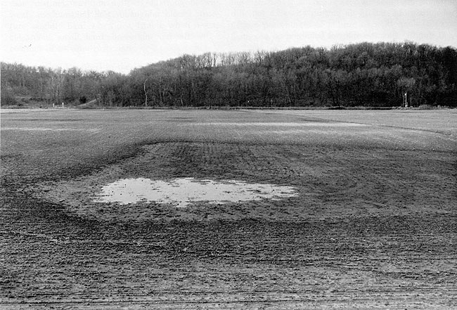
The gray colors in this soil indicate that the soil is under water for significant periods each year (Figure 9), because reducing conditions (absence of free oxygen) prevail to form gray colors in wet soils. The blocky structure is formed by the shrinking and swelling in the upper part of the profile; the lower part is massive clay and practically impermeable to sewage effluent. The clay of the Randall soil tends to become very hard when dry and is plastic when wet; wheeled vehicles and even crawler-type vehicles often become bogged down in Randall soils.
Figure 8--Schematic drawing of pit and soil profile as described by a soil scientist making a profile description during a soil survey (adapted from Dunmire and Bidwell, 1960, page 15).
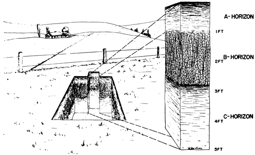
Figure 9--View of ponded soil area. Many soils in Kansas, including Randall soils, occupy low spots frequently wet or flooded. Generally these soils are not well drained, and large mottles (spots of different colors) recorded in their soil-profile descriptions. These places are generally poor for septic-tank seepage fields and sanitary landfill, but may be good sites for sewage lagoons.
Keith soils are among the better soils in Kansas for waste disposal. The following soil profile description was made during the soil survey of Finney County (Harner et al., 1965, page 73):
- A1p--0 to 7 inches, dark grayish-brown (10YR 4/2) loam, very dark grayish brown (10YR 3/2) when moist; weak, granular structure in upper part of plow layer and weakly platy in lower part; slightly hard when dry, friable when moist; noncalcareous; abrupt boundary (plow slice).
- A1--7 to 10 inches, dark grayish-brown (10YR 4/2) loam, very dark grayish brown (10YR 3/2) when moist; moderate, fine, granular structure; slightly hard when dry, friable when moist; worm casts; noncalcareous; clear, smooth boundary.
- AB--10 to 15 inches, dark-grayish-brown (10YR 4/2) heavy loam, very dark grayish brown (10YR 3/2) when moist; moderate, fine, granular structure; slightly hard when dry, friable when moist; numerous worm casts; noncalcareous; clear, smooth boundary.
- B21t--15 to 20 inches, grayish-brown (10YR 5/2) light clay loam, very dark grayish brown (10YR 3/2) when moist; moderate, fine, granular and weak, fine, subangular blocky structure; hard when dry, firm when moist; patchy clay films; pockets of worm casts; noncalcareous; clear, smooth boundary.
- B22t--20 to 24 inches, brown (10YR 5/3) light clay loam, dark brown (10YR 3.5/3) when moist; moderate, fine, subangular blocky structure; hard when dry, firm when moist; clay films; noncalcareous; clear, smooth boundary.
- Cca--24 to 60 inches, pale-brown (10YR 6/3) silt loam, brown (10YR 5/3) when moist; weak, subangular blocky structure; slightly hard when dry, friable when moist; calcareous; contains numerous concretions and threads of lime.
The brown colors in the Keith soils, without mottling, (spots) of different colors, indicate a well-drained soil that does not have high water tables for significant periods. The granular and blocky structures provide good aeration and permeability for septic-tank seepage fields and pits, but the loam textures have enough clay so that the soil will hold liquids fairly well in sewage lagoons. Keith soils are easy to excavate in sanitary landfill operations and have no bedrock, water table, or flooding limitations. Keith soils, of course, are also good for many other uses; land values are generally higher in these areas due to the competition for intensive uses of the best soils.
Kipson soils are shallow to limestone and shale bedrock. These areas occupy gently sloping hilltops with a thin soil mantle, and, in some parts of Kansas, steep sideslopes with rock outcrops. A typical soil profile of a Kipson soil was described in Republic County (Atkinson and Gier, 1967, pages 53-54):
- A1--0 to 10 inches, dark-gray (10YR 4/1) loam, very dark brown (10YR 2/2) when moist; moderate, fine, granular structure; slightly hard when dry, friable when moist; calcareous; numerous small fragments of limestone; gradual, smooth boundary.
- C--10 to 20 inches, white (10YR 8/ 1) shaly loam, pale brown (10YR 6/3) when moist; mass of soil and weathered fragments of limestone and calcareous shale.
- R--20 inches +, interbedded limestone and calcareous shale.
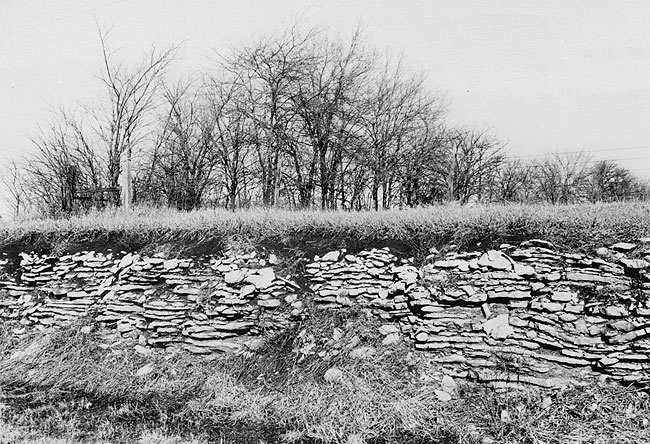
Kipson soils are very poor for most methods of waste disposal because of the shallowness to bedrock (Figure 10). Septic-tank seepage fields and pits in Kipson areas are very likely to pollute ground-water supplies for a considerable distance, because solution cracks and joints in the rock do not permit adequate filtration of the sewage effluent. These areas are unsuitable for sewage lagoons because the cracks in the bedrock would let the liquid waste drain out and contaminate ground water. Use of these soils for sanitary landfill is not recommended due to the shallowness to bedrock; even transporting soil material for cover from deeper soil areas may be too expensive if the distance is great.
Figure 10--View of shallow soil. Many soils in Kansas have bedrock at shallow depths; the specific bedrock-influenced soils and bedrock depths are listed in Table 1 and Table 6. If the bedrock is listed as "rippable," it can be dug out with common excavating equipment; if the bedrock is listed as "hard," it cannot be excavated easily. These soils may occupy nearly level or steep places--locations and slopes for each soil are shown on the detailed soil maps.
Many soils in Kansas have important soil characteristics with seasonal influences; their soil-profile descriptions must be very carefully studied to seek out the subtle criteria which are important for waste disposal. For example, many soils in Kansas have apparent water tables within 30 inches of the soil surface for significant periods during the late winter and early spring of each year. Although these soils are wet in late winter and early spring, the apparent water table drops in the summer due to transpiration by plants. Indications of wetness (mottles, or spots of different colors) remain in the soil even when the season is dry; the mottles indicate that the apparent water table will rise again when it rains. The Butler series, as described in Republic County (Atkinson and Gier, 1967, page 48), is one of the many soils in Kansas that have free water within 30 inches of the surface during the late winter and early spring:
- Ap--0 to 9 inches, dark-gray (10YR 4/ 1) silt loam, very dark gray (10YR 3/ 1) when moist; moderate, fine, granular structure and massive; slightly hard when dry, friable when moist; slightly acid; abrupt, smooth boundary.
- B21t--9 to 18 inches, dark-gray (10YR 4/1) silty clay, very dark grayish brown (10YR 3/2) when moist; moderate, medium, angular blocky structure; thick, dark-colored clay films; extremely hard when dry, very firm when moist; slightly acid; gradual, smooth boundary.
- B22t--18 to 24 inches, gray (2.5Y 5/1) silty clay, dark gray (2.5Y 4/1) when moist; few, distinct, fine mottles of strong brown; moderate, medium, angular blocky structure; thick clay films; extremely hard when dry, very firm when moist; neutral; gradual, smooth boundary.
- B3ca--24 to 38 inches, light brownish-gray (2.5Y 6/2) heavy silty clay loam, grayish brown (2.5Y 5/2) when moist; common, distinct, fine mottles of strong brown; moderate, medium and fine, angular blocky structure; moderately thick clay films; very hard when dry, firm when moist; mildly alkaline; numerous concretions of calcium carbonate; gradual, smooth boundary.
- Cca--38 to 60 inches, light-gray (5Y 7/2) light silty clay loam, olive gray (5Y 5/2) when moist; common, distinct, medium mottles of strong brown; weak, medium and fine, subangular blocky structure; slightly hard when dry, friable when moist; calcareous; small, hard concretions and soft, white coatings of calcium carbonate.
The mottles described in the B22t, B3ca, and Cca horizons of the Butler series are especially critical, because they indicate periodic wetness. Septic-tank seepage fields and pits in the Butler soils will not function below 30 inches in the late winter and early spring when the apparent water table is above that depth. If artificial water diversion and drainage is provided, of course, the soil is improved over its natural condition for effluent seepage. Seasonal water tables in Butler soils also affect their use for sewage lagoons and sanitary landfill. The soil-profile descriptions of the soils, however, indicate the soils' problems to be encountered for waste disposal and the corrections that might need to be made to overcome them.
Research on Soils for Waste Disposal
Soil scientists and engineers have carried out considerable research on the use of soils for waste disposal. Literature reviews discussing soils' implications for septic-tank effluents (Cain and Beatty, 1965; Keppner, 1972), municipal effluents (Ramsey et al., 1972) and public health and engineering aspects (Olson: 1964) list many references. In addition, many publications (Bender, 1971; Porter and Pettry, 1971) show how soil maps can lead to enhanced environmental quality through good planning.
The percolation test for waste disposal in soils has been subjected to rigorous evaluation on a statistical areal basis (Derr et al., 1969); proposals for improved tests have been made (Bouma, 1971). The percolation test is important because it measures the rates at which water flows through soils and gives an approximation of effluent seepage capacity for design purposes. Morris et al. (1962) suggested that detailed soil maps can substitute for percolation tests, probably with better results. Studies also have related percolation rates to soil-map units (Persinger and Yahner, 1970), and measured seasonal apparent water-table variations in soils affecting waste disposal (Latshaw and Thompson, 1968; Fritton and Olson, 1972).
Hill (1972) evaluated the waste-water renovation potential of several soils, and found that soil properties affected the results to a considerable extent. Huddleston and Olson (1967) outlined a technique by which seepage-field designs can be specified for areas on detailed soil maps, on the basis of percolation tests related to soil-map units, with accessory studies showing statistical incidence of seepage-field failures in the different soils. By putting all of this information together, percentages of failures of septic-tank seepage fields can be predicted for different soils (Figure 11), and, conversely, engineering systems which will give satisfactory performances over a long period of time can be prescribed for each soil on the map.
Figure 11--House on clayey soils with slow permeability and severe limitations for septic-tank seepage fields. Sewage effluent seeps downslope and collects in the ditch shown at the bottom of the photograph. Rank vegetative growth indicates soil seepage, fertilized by nutrients in the sewage effluent. Research on failing septic tanks helps to indicate soil conditions which produce slight, moderate, or severe limitations for seep- age fields. Percentages of septic-tank failures, of course, are smaller in the soils with slight limitations that have moderate or rapid permeability.
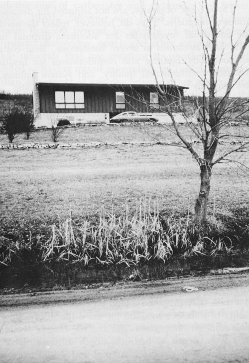
Ultimately, most septic-tank failures are due to inadequate investments in the engineering systems for the different soils. Although any soil can be made suitable for any purpose with unlimited funds, most soils with severe limitations require such expensive seepage fields or other structures for adequate effluent treatment that the feasibility of construction may be questionable. Builders of homes with septic tanks should select sites with slight limitations for effluent disposal; soil maps thus can be of great help for environmental improvement, as well as in cutting construction costs. Popkin and Bendixen (1968) have published some cost figures for seepage fields in various soils. Although their calculations appear to be largely theoretical, and their assumptions of percolation rates are not realistic for most soils of Kansas, soils are shown to be a major factor determining costs of on-site sewage disposal--especially if costs of system failures and duration of satisfactory performances can be included in the evaluation. Relative costs for seepage field designs in different soils, for homes with five occupants and three bedrooms, using recommended systems (Popkin and Bendixen, 1968), were:
| Good soil with practically no limitations | $515 |
| Fair soil with few limitations | $651 |
| Poor soil with some limitations | $1,244 |
These costs, of course, are not adjusted for devaluations or inflations. They do, however, reflect the need for additional investments for adequate disposal in soils with moderate to severe limitations. Real costs on poor soils, figuring also considerations for health hazards, environmental quality, and system failures, are probably much higher than these data indicate.
Wall and Webber (1970) have published a paper on soil characteristics and subsurface sewage disposal which is relevant for planning around reservoirs in Kansas; their study area had cottages with failing septic tanks on the shore of a eutrophic lake that had "become weed-choked within the past five years." Ten out of 14 samples of ground-water associated with tile systems on poorly drained soils had phosphorus in excess of 0.01 to 0.02 ppm. Ground-water analyses from 11 sites associated with septic-tank systems had concentrations as high as 4.4 ppm NO3-N, 2.0 ppm P, and 46,000 coliform bacteria (MPN/100 ml). Water quality analyses from five wells used as sources of drinking water in the area had concentrations as high as 0.73 ppm NO3-N, 0.027 ppm P, and 1,700 coliform bacteria (MPN/100 ml). [Note: When more than two coliform bacteria are present in 100 mls of sample, the water can be suspected of containing sewage or soil bacteria that may be injurious to health.] On the basis of their observations and data, they proposed a plan for classifying the suitability of soils as a medium for the disposal of septic-tank effluents. Important "soil and site factors" evaluated were depth to bedrock, depth to water table, slope, seepage, stoniness, natural soil drainage, soil texture, and soil structure. The suitability classes of soils which they proposed are similar to those presented in this publication, except that Wall and Webber (1970) suggest five suitability classes of soils instead of three classes.
Prev Page--Landscapes || Next Page--Classification
Kansas Geological Survey, Geology
Placed on web Aug. 7, 2009; originally published March 1974.
Comments to webadmin@kgs.ku.edu
The URL for this page is http://www.kgs.ku.edu/Publications/Bulletins/208/03_desc.html