![]()
Previous Page--Paleozoic || Next Page--Mississippian
ORDOVICIAN SYSTEM
By Edwin D. Goebel
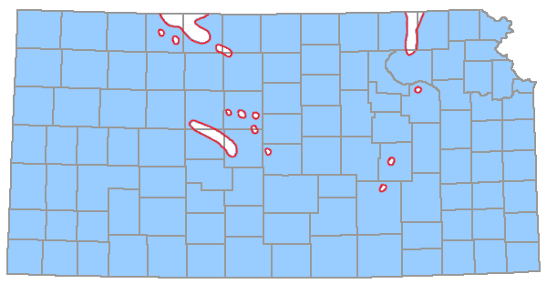
The Ordovician System in Kansas includes thick sequences of dolomite and dolomitic limestone overlain by sandy dolomite, sandstone, limestone, and shale. All are found in the subsurface. Their distribution (Fig. 3) is statewide, except in places on the Central Kansas uplift and the Nemaha anticline. (Lower Ordovician rocks were discussed under the section Undifferentiated Upper Cambrian and Lower Ordovician.)
Figure 3--Distribution of Cambrian and Ordovician rocks in Kansas (shaded area) (adapted from Merriam, 1963).
Middle Ordovician Series
Middle Ordovician rocks above the Arbuckle Group comprise the Simpson Group, which includes unnamed beds of sandstone and shale, the St. Peter Sandstone, the Platteville Formation, and the Viola Limestone. Simpson rocks in Kansas represent only a part of the Simpson of Oklahoma, where the rocks exceed 1,500 feet in thickness (Lee, 1956).
Simpson Group
Probably Simpson rocks formerly were present throughout eastern and central Kansas, but pre-Devonian (or pre-Chattanooga) erosion removed them from the Chautauqua arch, and early Mississippian and early Pennsylvanian erosion removed them from considerable areas on the Central Kansas uplift and northern part of the Nemaha anticline. In the Hugoton embayment, the Simpson is represented by about 90 feet of sandy dolomite, white dolomitic sandstone, and blue-green to gray shale, which thins to the north and west.
ST. PETER SANDSTONE and LOWER SIMPSON BEDS
The St. Peter Sandstone and the underlying green shale and sandstone, which occur near the Oklahoma border, are part of the Simpson Group.
A shaly zone in the middle part of the St. Peter in northeastern Kansas becomes more prominent southward, and westward, near the Oklahoma border, upper St. Peter Sandstone is underlain by beds of light-green and dark-green clay shale, sandy clay, and sandstone. An angular unconformity separates gently dipping St. Peter and associated Simpson beds from underlying rocks. The St. Peter overlies Precambrian and Upper Cambrian rocks on the Nebraska arch in northeastern Kansas. Abnormal thicknesses of St. Peter Sandstone, especially in eastern Kansas, are thought to represent sinkhole fillings (Lee et al., 1946; Merriam and Atkinson, 1956). The thickness of the St. Peter Sandstone averages about 50 feet in northeastern Kansas. The St. Peter and associated Simpson rocks increase in thickness to 190 feet near the Oklahoma state line.
PLATTEVILLE FORMATION
The upper beds of the Platteville Formation in Kansas consist of dolomite, limestone, sandstone, and green shale, and in the basal part is a persistent dolomite 5 to 35 feet thick. Some sand generally occurs in the basal dolomite and disseminated in the shales and dolomites of the upper part. The formation is restricted to the North Kansas basin. The Platteville is unconformable on the St. Peter Sandstone in northeastern Kansas (Lee et al., 1946). Maximum known thickness of the formation in Kansas is 100 feet in Brown County; it wedges out southward on the flanks of the Chautauqua arch and the Central Kansas uplift.
Twenhofel and others (1954) assigned a Middle Ordovician (Blackriveran) age to outcropping Platteville rocks in Missouri. Leatherock (1945) correlated the Platteville in Kansas with the Decorah of Missouri.
VIOLA LIMESTONE
The Viola Limestone of Kansas, which represents only part of the Viola of Oklahoma, consists of dolomite and limestone strata containing some cherty beds characterized by black flecks and spicular and tubelike fragments of microorganisms. In deep parts of the North Kansas basin, the carbonate rocks of the Viola are dominantly dolomite, but toward margins of the basin earthy and granular limestone beds are present, especially at the base. There is an unconformity between Viola and Platteville rocks in Kansas (Lee, 1956). The Viola occurs throughout the State except in places on the Central Kansas uplift, in northwestern Kansas, on the Chautauqua arch, and on the northern end of the Nemaha anticline. In the Hugoton embayment it is overlain unconformably by Mississippian rocks and oversteps underlying Simpson Group and older rocks eastward (Merriam and Atkinson, 1955) and westward (Maher and Collins, 1949). In eastern Kansas the Viola is 310 feet thick (Washington County), and it thins southward to 20 feet in Harvey County. In southwestern Kansas, where it is difficult to discern from Arbuckle rocks, the Viola thickens from 0 feet on the flanks of the Central Kansas uplift to more than 200 feet in the deepest part of the Hugoton embayment at the Oklahoma state line.
Upper Ordovician Series
Upper Ordovician rocks in Kansas are composed of beds of dolomite, dolomitic shale, and shale. They are restricted principally to the area of the North Kansas basin.
MAQUOKETA SHALE
The Maquoketa Shale of northeastern Kansas characteristically consists of greenish-gray, silty dolomitic shale or cherty, silty dolomite. Graptolites have been reported from Maquoketa cores from central Kansas. In southern Kansas, the Maquoketa becomes more argillaceous and less cherty and dolomitic. An angular unconformity between the Maquoketa Shale and the underlying Viola Limestone is revealed by the overlap, toward the southwest, of the Maquoketa upon progressively older beds of the Viola. Probably, the Maquoketa Shale is an equivalent of the Sylvan Shale in Oklahoma, but was removed from the Chautauqua arch by pre-Devonian or pre-Chattanooga erosion (Lee, 1956). The Maquoketa is not recognized in southwestern Kansas. In eastern Kansas, where it occurs beneath Silurian rocks, the Maquoketa ranges from 155 feet in the north to less than 40 feet in the south.
UNDIFFERENTIATED SILURIAN and DEVONIAN
By Edwin D. Goebel
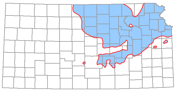
Silurian and Devonian rocks (Fig. 4) consist mainly of dolomite and limestone and are restricted in distribution to northeastern and north-central Kansas (North Kansas basin, Fig. 2). Although the Silurian and Devonian rocks overlap some Ordovician rocks, they are more closely in accord with Ordovician than with Mississippian rocks (Merriam, 1963). Silurian rocks disconformably overlie Ordovician rocks (Maquoketa Shale). A disconformity separates Silurian and Devonian rocks (Lee, 1956). Devonian carbonate rocks are separated from undifferentiated Devonian-Mississippian rocks (the Chattanooga Shale) by an unconformity. These rocks are subsurface only.
Figure 4--Distribution of Silurian and Devonian rocks in Kansas (shaded area) (adapted from Lee, 1956; Hilpman, 1967).
"Hunton Group"
Limestone and dolomite strata of Silurian and Devonian ages are called the "Hunton Group." In Oklahoma, where the term "Hunton" was first applied, the group consists of Silurian rocks as well as Lower Devonian rocks. Most of the Devonian portion of the "Hunton" in Kansas is no older than Mid-Devonian in age (Hilpman, 1967) and the Silurian portion is no younger than Mid-Silurian in age.
CHIMNEYHILL DOLOMITE
Silurian rocks (Chimneyhill Dolomite) consist mostly of light-gray to buff, fine- to medium-crystalline dolomite. On the margin of the North Kansas basin some limestone is interbedded with the dolomite. The lower part of the Silurian rocks includes beds of dolomitic oolites at the base, overlain by beds containing opaque white chert and slightly silty dolomite (Lee, 1956) with sparsely distributed siliceous foraminifers (Ireland, 1966). Higher strata are mostly coarsely crystalline white dolomite. The lower beds of the Kansas Chimneyhill may be equivalent to the Chimneyhill Limestone of Oklahoma (Lower Silurian). The Silurian rocks rest disconformably on Maquoketa Shale, but without marked relief. A disconformity separates Silurian from Devonian rocks (Lee, 1956). Lack of sand grains mainly distinguishes the Silurian rocks of Kansas from Devonian rocks. In Kansas, Silurian rocks are restricted to the ancient North Kansas basin and to an area north of the Chautauqua arch. Maximum thickness of Silurian rocks in Kansas is 435 feet in Nemaha County.
Devonian rocks in the North Kansas basin consist mostly of relatively pure lithographic and sublithographic limestones that grade westward and northwestward into dolomite. In some places, particularly just east of the Nemaha anticline, the Devonian rocks are coarsely crystalline and porous. A cherty zone commonly ocurs 30 to 100 feet above the base. Basal Devonian beds, consisting of sandy dolomite or limestone, are distinguished readily from nonsandy Silurian rocks (Chimneyhill). An unconformity which occurs at the base of the Devonian section is one of the most pronounced in the geologic sequence of Kansas, for it represents local pre-Devonian erosion of Silurian and older rocks that were hundreds of feet thick (Lee, 1956). In eastern Kansas, Devonian rocks successively overlap Silurian, Upper Ordovician (Maquoketa), and Middle Ordovician (Viola) rocks from north to south. Devonian carbonate rocks now are confined to central and eastern Kansas, where they occur flanking the Central Kansas uplift and the Chautauqua arch. They are not recognized in the Hugoton embayment, but reworked Devonian microfossils have been reported from the southwest flank of the Central Kansas uplift (Goebel, 1966). Middle Devonian rocks are reported by Hilpman (1967) in southern Stafford County on the Pratt anticline. The maximum known thickness of Devonian carbonate rocks (greater than 250 feet) occurs in Doniphan County in northeastern Kansas.
Undifferentiated Upper Devonian and Lower Mississippian
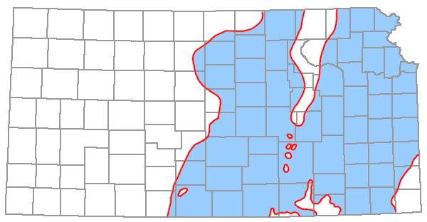
The shale sequence between Devonian and Mississippian carbonate rocks in northeastern Kansas is divided into two formations, the Chattanooga Shale below and the Boice Shale above. They are separated by a marked disconformity with as much as 110 feet of topographic relief locally (Lee, 1956). The Chattanooga Shale extends over most of the eastern two-thirds of Kansas (Fig. 5). It is probable that the Chattanooga Shale (often miscalled "Kinderhook shale" in Kansas) is Mississippian and Devonian in age and that the Boice Shale is Mississippian (Kinderhookian) in age only. All of this sequence occurs in the subsurface.
Figure 5--Distribution of undifferentiated Devonian and Mississippian rocks (Chattanooga Shale) in Kansas (shaded area) (adapted from Lee, 1940).
CHATTANOOGA SHALE
The Chattanooga Shale is silty, pyritiferous, and, in some places, partly dolomitic. Spores occur sparsely throughout the shale, but are most common in basal beds. The shale is black in southern Kansas, but it grades northward into gray shale. The Chattanooga Shale is separated from underlying rocks by an angular unconformity. From north to south, the Chattanooga overlaps rocks ranging in age from Middle Ordovician to Devonian (Lee, 1940). It is present in most of eastern and central Kansas, but it is absent at the northern end of the Nemaha anticline. The Chattanooga extends in an almost continuous sheet westward to a line from Clark County on the south to Osborne County on the north. Its thickness ranges from 0 feet in Osborne, Clark, and intermediate counties to more than 250 feet in northeastern Kansas near the Nebraska border. Abnormal thicknesses of Chattanooga Shale occur in McPherson County and areas to the east, where the formation was deposited in valleys eroded into the older rocks (Lee, 1956).
Misener Sandstone Member
The Misener, occurring at the base of the Chattanooga Shale, is a distinct unit in some places, but in most of eastern Kansas it is represented only by disseminated, rounded sand grains.
BOICE SHALE
Dark or light greenish-gray, spore-bearing silty or dolomitic shale and basal beds of red shale or ferruginous oolite comprise the Boice Shale. These strata conformably underlie the Chouteau Limestone or occur disconformably beneath the upper Sedalia Dolomite (both Kinderhookian). The Boice is disconformable upon the Chattanooga Shale. It is confined to northeastern Kansas, extending somewhat to the west of the Nemaha anticline. Its present known thickness is 110 feet near the Nebraska border in Brown County.
Previous Page--Paleozoic || Next Page--Mississippian
Kansas Geological Survey, Stratigraphic Succession in Kansas
Comments to webadmin@kgs.ku.edu
Web version August 2005. Original publication date Dec. 1968.
URL=http://www.kgs.ku.edu/Publications/Bulletins/189/05_ordo.html