![]()
Previous Page--Pennsylvanian || Next Page--Cenozoic
Mesozoic Era
Most of the deposits of Mesozoic age in Kansas belong to the Cretaceous System. Older Mesozoic rocks, representing the Jurassic System, are identified in well borings and locally in two small exposures in Morton County.
The outcrops of Mesozoic strata in Kansas are confined to the western two-thirds of the State. They extend much farther eastward along the northern border (eastern Washington County) than along the southern border (Barber County); in central Kansas, exposures are found eastward as far as Dickinson and Marion counties. Mesozoic rocks are unconformably separated from Paleozoic and Cenozoic rocks. The aggregate thickness of Mesozoic rocks is about 3,350 feet (Merriam, 1963).
JURASSIC SYSTEM
By Howard G. O'Connor
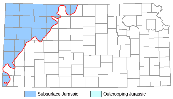
Deposits judged to be Jurassic in age (Fig. 9) occur in the subsurface in northwestern Kansas and crop out in a small area in southern Morton County. They consist primarily of varicolored shales and red sandstones and attain a maximum thickness of about 350 feet. In the subsurface they pinch out eastward along an irregular line extending from Morton County to Smith County and, in general, thicken toward the west. The Jurassic beds in southwestern Kansas, formerly classified as Triassic, Dockum (?) Group, have been restudied and are now designated as undifferentiated Jurassic (E. D. Gutentag, personal communication with H. G. O'Connor, 1966, 1967; see also Voegeli and Hershey, 1965).
Figure 9--Distribution of Jurassic rocks in Kansas (modified from Moore et al., 1951).
Upper Jurassic Series
In Morton County undifferentiated beds of red siltstone and buff, green, and white sandstone that are believed to be equivalent in part to the Entrada Sandstone of Colorado underlie the Morrison Formation and overlie the Permian Big Basin Formation. The maximum exposed thickness is about 40 feet, but in the subsurface of Stanton and Hamilton counties, the thickness is about 250 feet (Gutentag, ibid.).
MORRISON FORMATION
The upper Morrison beds are chiefly green sandy shale containing limestone lenses. The lower shale beds contain pink chert, anhydrite, and gypsum. Where noted in wells, the Morrison Formation ranges in thickness from 100 to 350 feet (Merriam, 1963).
CRETACEOUS SYSTEM
By Howard G. O'Connor
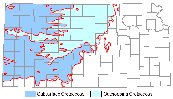
Rocks of Cretaceous age crop out at the surface or underlie much of central and western Kansas (Fig. 10). These rocks are mostly marine, but parts of the Cheyenne Sandstone and Dakota Formation are of nonmarine origin. The predominant lithology of rocks of the system is shale. Chalk, limestone, and chalky shale comprise most of the middle beds. Sandstone is conspicuous in the lower beds. The thickness of the Cretaceous System in Kansas is about 3,000 feet.
Figure 10--Distribution of Cretaceous rocks in Kansas (adapted from Moore et al., 1951; State Geol. Survey Kansas, 1964).
A major unconformity occurs at the base of the Cretaceous rocks. The contact is marked locally by a zone of pebbles and cobbles. The Cretaceous rocks overlap northward on the pre-Cretaceous erosion surface, with successively younger beds lying above the contact northward across the State, ranging from the Cheyenne Sandstone in Comanche and Kiowa counties to the Dakota Formation in Washington County. Rocks underlying the unconformable contact range from the Permian Herington Limestone Member in Washington County to beds believed to be of Jurassic age in northwestern Kansas.
In the subsurface, rocks assigned to the Lower Cretaceous Series display lateral variability and progressive overlap on pre-Cretaceous rocks. Rocks of the Upper Cretaceous Series display a remarkable degree of uniformity throughout their area of occurrence in the State; although some progressive changes in thickness occur, their essential characteristics remain the same.
Lower Cretaceous Series
The Lower Cretaceous Series in Kansas (formerly Comanchean Series) is correlated with the Comanchean Series of Texas on evidence of abundant fossils found in the Kiowa Formation.
The oldest Cretaceous deposits in Kansas represent nonmarine and littoral deposits laid down as the sea advanced northeastward. The nonmarine deposits rapidly gave way to sediments laid down in a brackish-marine environment, and marine shales and sandstones overlie and overlap the older nonmarine deposits. Lower Cretaceous rocks crop out in a belt extending diagonally across Kansas from Washington County to Comanche County, and in scattered areas in southwestern Kansas. The maximum thickness is about 400 feet.
CHEYENNE SANDSTONE
The Cheyenne Sandstone comprises massive, white to buff to light-gray, mostly fine-grained, and partly crossbedded sandstone, lenses of gray sandy shale and conglomerate, and locally minor amounts of clay, selenite crystals, ironstone nodules, and pyrite. A zone of pebbles and cobbles occurs locally at the base. Plant fossils are found in the dark shales in the upper part. The thickness in outcrops in Barber, Kiowa, and Comanche counties ranges from 0 to 94 feet. The Cheyenne thickens westward in the subsurface. The maximum subsurface thickness is 300 feet.
KIOWA FORMATION
The Kiowa Formation (formerly Kiowa Shale) consists chiefly of light-gray to black, illitic shale (Franks, 1966). [The State Geological Survey of Kansas has adopted the proposal by Paul C. Franks (1966) to change the name "Kiowa Shale" to "Kiowa Formation."] Locally it contains thin coquinoidal limestone beds, with the "Champion shell bed" (Cragin, 1895) at the base in much of the type area. Fossil plants are found in several beds in the Kiowa. Sandstone lenses occur within the shale sequence, but are most abundant in the upper parts of the formation in central and southwestern Kansas. Locally, in north-central Kansas, sandstone may approximate as much as 80 percent of the Kiowa Formation. Lenses and concretions of calcareous cone-in-cone are common in the shale. Sandstone with calcite cement is locally abundant. Selenite crystals are common on weathered slopes. The Kiowa pinches out or becomes unidentifiable in north-central Kansas at about the Clay-Washington county line; it thickens southwestward to achieve a maximum thickness in the type area in Kiowa County. The top commonly is marked by bench-forming sandstone showing cross-stratification, transverse ripple marks, small U-shaped burrows, and concretionary masses of calcite cement. Along the eastern fringes of much of the Kiowa outcrop belt in north-central Kansas, the lower parts of the Kiowa Formation are marked by a bed or zone of siltstone that is underlain by gray mudstone and claystone with red mottles, carbonaceous dark-gray claystone and mudstone, and lignitic material. The thickness ranges from 60 to 150 feet.
DAKOTA FORMATION
The Dakota Formation comprises white, gray, red, brown, and tan kaolinitic claystone, mudstone, shale, and siltstone, as well as interbedded and lenticular sandstone. It contains carbonaceous material, lignite, and locally sandstone cemented with calcite or iron oxide. Granular aggregates of iron oxide are seen on weathered surfaces. Grains or pellets of siderite are common in much of the claystone and mudstone. The Dakota Formation occurs in north-central and western Kansas. It contains fossil plants and land vertebrates. The thickness ranges from 200 to 300 feet (Franks, 1966).
[Note: In Kansas, the Dakota Formation is underlain by the Kiowa Formation, which is Lower Cretaceous and is correlated with the Kiamichi and Duck Creek formations of the Comanchean Series of Texas. Although the Dakota Formation is largely devoid of diagnostic marine fossils, fossils of supposed Early Cretaceous age have been found near the top of the Dakota Formation in its type area in northeastern Nebraska (Tester, 1952) and also in southeastern Colorado (McLaughlin, 1954). More recently, a faunal assemblage found at the top of the Dakota Formation in central Kansas has been assigned a Late Cretaceous age (Hattin, 1967). Thus, the boundary between the Lower and Upper Cretaceous cannot be located accurately and, in most places, properly should be placed within the Dakota Formation.]
Terra Cotta Clay Member
This member consists of interbedded claystone, shale, and siltstone, which are mainly gray or greenish-gray with abundant red mottles. Grains and pellets of siderite are common in the claystone and siltstone. The Terra Cotta contains abundant interbedded and lenticular, fine- to coarse-grained sandstone, cemented with iron oxide, and locally it is cemented with calcite. The sandstone generally weathers brown. Carbonaceous matter and lignitic beds are common near the base. The thickness ranges from 70 to 200 feet.
Janssen Clay Member
Gray to dark claystone, siltstone, and fissile shale, with lenticular sandstone, lignite, and lignitic clay make up the Janssen Clay Member. Locally it contains lenses or beds of red mottled greenish-gray claystone and siltstone with abundant grains and pellets of siderite. Concretionary iron oxide is common near the base of the member. The Janssen occurs in central and north-central Kansas. The thickness ranges from 30 to 80 feet.
Upper Cretaceous Series
In Kansas, the Upper Cretaceous Series (formerly Gulfian Series) is represented by marine shales and limestones constituting the Colorado and Montana groups. Its thickness is about 2,500 feet.
Colorado Group
Calcareous and noncalcareous shales and chalk of this group underlie the surface of and crop out in north-central, northwestern, and west-central Kansas. Limestone is interbedded with the calcareous shales. These rocks are all of marine origin. Their thickness is about 900 feet.
GRANEROS SHALE
The predominant lithology of this formation is fissile, noncalcareous, medium-gray to dark-gray shale that weathers to shades of gray and yellowish-brown. Beds of calcareous and non-calcareous sandstone and siltstone lie in the middle part of the Graneros Shale at many localities. Clay-ironstone and calcareous septarian concretions occur locally in the shale beds. Selenite crystals are abundant on the weathered shale slopes. Several layers of bentonite and beds of skeletal limestone lie in the middle and upper part of the formation. Ostrea, Inoceramus prisms, and fish scales are found locally. The thickness ranges from 24 to 44 feet in central Kansas (Hattin, 1965) to 65 feet near the Colorado state line.
GREENHORN LIMESTONE
This formation comprises thin-bedded, light-gray to dark-gray, chalky limestone and calcareous shale that weathers yellowish-gray to light gray. The thickness is 64 feet in Ellsworth County, 95 feet in Ellis County, and 132 feet in Hamilton County.
Lincoln Limestone Member
The Lincoln Limestone Member is made up of interbedded, light-gray chalky shale and chalky limestone that weathers to yellowish-gray or yellowish-tan. Beds of dark-gray, petroliferous, hard, crystalline limestone occur at the base and the top of the member. The shales contain thin beds of bentonite. Fossils include Inoceramus and sharks' teeth. The thickness ranges from about 2 to 35 feet.
Hartland Shale Member
This member comprises gray, chalky shale with a few thin beds of chalky limestone and bentonite. The upper part becomes more chalky southwestward. Fossils include Inoceramus and ammonites. The thickness ranges from 23 feet in Kearny County to 35 feet in Ellis County.
Jetmore Chalk Member
The Jetmore Chalk Member contains interbedded gray chalky shale and chalky limestone that weathers light gray. A small species of Inoceramus is common in the "shell rock limestone" at the top of the member. Ammonites occur in some beds. The thickness averages 22 feet.
Pfeifer Shale Member
The Pfeifer Shale Member consists of interbedded chalky shale and chalky limestone. The Fence-post limestone bed, at the top of the member, is bluish-gray, weathering light tan. In Hamilton County the Pfeifer Shale Member and the underlying Jetmore Chalk Member are thicker than they are farther to the east. In this county where the two members cannot be distinguished, they have been called the "Bridge Creek limestone member," and have a total thickness of 74 feet (Bass, 1926). The limestone beds contain Inoceramus labiatus. The thickness of the Pfeifer averages 20 feet.
CARLILE SHALE
This formation consists of chalky shale with bentonites and thick chalk beds, dark-gray fissile shale containing large septarian concretions, and fine-grained sandstone. The thickness is about 300 feet.
Fairport Chalk Member
This member (formerly Fairport chalky shale member) comprises bluish-gray to gray, chalky shale, chalky limestone, and calcareous shale that weathers to yellowish-gray and grayish-orange. Thin bentonite beds occur throughout the member. Chalky limestone is more abundant near the base. Fossils include Inoceramus and Ostrea, and ammonites, fish scales, and sharks' teeth. Worm tubes, bryozoans, and barnacles are common in the middle part of the member (Hattin, 1962). The thickness is 85 feet in Russell County and 147 feet in Hamilton County.
Blue Hill Shale Member
The Blue Hill Shale Member is a dark-gray, clayey, blocky to fissile, shale. It becomes more sandy toward the top. Calcareous septarian concretions and clay-ironstone concretions occur in several zones. Pyrite nodules and selenite crystals are common locally. The most common fossils are pelecypods and ammonites. The thickness ranges from about 70 feet in Hamilton County to 200 feet in Jewell County.
Codell Sandstone Member
This member (formerly called "the Codell sandstone zone") is fine-grained, silty sandstone that locally becomes shaly. The lower contact is usually gradational. Fossils are sparse. The maximum thickness is 25 feet in northern Ellis County, thinning to about 1 foot to the northeast and south.
NIOBRARA CHALK
This formation (formerly Niobrara formation) consists of interbedded, soft, light-gray calcareous shale and chalk. It crops out in a belt trending generally northeast-southwest and extending from north-central to western Kansas. The thickness is 500 to 750 feet in Logan and Wallace counties and averages 600 feet.
Fort Hays Limestone Member
The Fort Hays Limestone Member is a massively bedded, gray to cream-colored chalk or chalky limestone. Thin beds of light- to dark-gray, chalky shale separate the massive chalk beds. The Fort Hays is characterized by a large species of Inoceramus. The thickness ranges from 30 feet in Jewell County to 65 feet near the Colorado state line.
Smoky Hill Chalk Member
The Smoky Hill Member comprises gray, shaly chalk and interbedded shale and chalk that weathers white, yellow, and orange. The Smoky Hill contains limonitic concretions and locally, massive chalk beds. A notable fossil is a species of Inoceramus which may attain 3 feet in length. Other invertebrates include Ostrea and occasional ammonites. The member contains well-preserved vertebrates, both fish and reptile. The thickness ranges from 450 to 700 feet.
Montana Group
The Montana Group comprises dark-colored marine shales that occur in northwestern Kansas. Only one formation in this group is present in Kansas.
PIERRE SHALE
This formation consists of thin-bedded, black to dark-gray and light-gray shale that weathers to gray and coffee-brown. It contains concretions, selenite crystals, thin beds of bentonite, and, locally, chalky beds. The thickness ranges from 1,000 to 1,600 feet.
Sharon Springs Shale Member
The Sharon Springs is a flaky, black, somewhat bituminous shale. Large clay-ironstone septarian concretions and calcareous concretions are abundant in the upper part. A few beds of light-gray shale and, locally, thin chalk beds are found in the lower part. The thickness is 155 feet.
Weskan Shale Member
The Weskan is a gray, clayey shale. It contains large calcareous concretions and some limonite. Bentonite beds are most abundant in the lower part. The thickness is 170 feet.
Lake Creek Shale Member
This member is a dark-gray to black, thin-bedded, flaky shale. It contains limestone concretions, zones of concretionary limonite, and, locally, gypsum. The thickness is 200 feet.
Salt Grass Shale Member
The Salt Grass is a gray, clayey shale containing numerous thin bentonite beds, calcareous concretions, and concretionary limonite zones distributed throughout. Its thickness is 60 feet.
Lying between the Salt Grass Shale Member and the Beecher Island Shale Member is from 500 to 600 feet of undifferentiated gray to black shale.
Beecher Island Shale Member
The Beecher Island is a gray shale containing calcareous concretions in the lower part, thin beds of bentonite, limonitic concretions throughout, and irregular concretionary limestone near the top. The thickness is about 100 feet.
Previous Page--Pennsylvanian || Next Page--Cenozoic
Kansas Geological Survey, Stratigraphic Succession in Kansas
Comments to webadmin@kgs.ku.edu
Web version August 2005. Original publication date Dec. 1968.
URL=http://www.kgs.ku.edu/Publications/Bulletins/189/09_meso.html