![]()
Previous Page--Mesozoic || Next Page--Igneous and Metamorphic
Cenozoic Era
Deposits of Cenozoic age are widespread in Kansas. They constitute a discontinuous veneer upon the eastward-sloping pre-Cenozoic erosion surface and comprise Tertiary deposits that cover much of western Kansas but are of only local occurrence elsewhere, and Quaternary sediments that include glacial deposits in northeastern Kansas and nonglacial deposits of Pleistocene age in all parts of the State.
TERTIARY SYSTEM
By Charles K. Bayne and Howard G. O'connor
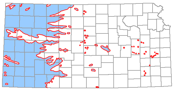
Deposits of Tertiary age occur widely in western Kansas and locally in central and eastern Kansas (Fig. 11). The Tertiary rocks are nonmarine and are predominantly stream-laid deposits. The source of most of these deposits was to the west, principally the area of igneous rocks in the Rocky Mountain Region and the area of sedimentary rocks in eastern Colorado and extreme western Kansas. The thickness of the Tertiary deposits ranges from a few feet to more than 350 feet, but the maximum thickness has nowhere been observed at the surface. At one time the Tertiary alluvium constituted a surface of low relief that merged westward with the erosion surface in the Rocky Mountains and eastward with the Flint Hills, which formed a divide in east-central Kansas. The Flint Hills was a local source of sediment (mostly chert gravels). A short distance west of the Flint Hills, chert gravels are interfingered with arkosic material derived from the Rocky Mountains. Tertiary deposits east of the Flint Hills are largely accumulations of chert gravel in a brownish-red clay and are less than 20 feet thick. These occur as dissected terrace deposits at elevations 100 to 200 feet higher than the present major streams. Some of these chert gravels are believed to be of Pliocene age or older. No formal stratigraphic name has been applied to these gravels derived from the Flint Hills Region.
Figure 11--Distribution of Tertiary rocks in Kansas; subsurface and outcropping Tertiary shown in blue (modified from Moore et al., 1951; State Geol. Survey Kansas, 1964).
Tertiary rocks unconformably overlie beds of Cretaceous, Jurassic, Permian, and Pennsylvanian ages.
Pliocene Series
Rocks of Tertiary age in Kansas are all included in the Pliocene Series. One formation is recognized.
OGALLALA FORMATION
The Ogallala is massive to crossbedded, generally arkosic gravel, sand, and silt, locally cemented with calcium carbonate. It is greenish-gray, pink, red, tan, and ash-gray in color. It contains limestone, volcanic ash, diatomaceous marl, opaline sandstone, and bentonitic clay. It contains diagnostic vertebrate and plant fossils. The Ogallala is distributed widely over the western one-third of Kansas and in a few places in the central part of the State. The maximum thickness of the Ogallala is about 350 feet.
The Delmore Formation, consisting of sands and gravels in McPherson and nearby counties, is equivalent in part to the Ogallala (Frye, Leonard, and Swineford, 1956, p. 57). The Rexroad Formation, which is late Pliocene in age, is probably equivalent to the upper part of the Ogallala. Similarly, some of the chert gravels in upland positions east of the Flint Hills may be of Pliocene age.
Valentine Member
The Valentine Member consists of greenish-gray, pink, and gray silt, sand, and gravel that is loosely cemented locally forming "mortar beds." It also contains opaline sandstone, bentonitic clay, and diatomaceous marl. The Stipidium fossil seed zone occurs in this member. The maximum thickness is more than 100 feet. The Valentine occurs only in topographically low positions on the Mesozoic and Paleozoic erosional surface where it is overlain by the Ash Hollow Member.
Ash Hollow Member
Sand, gravel, and silt of the Ash Hollow Member is loosely cemented in many zones forming "mortar beds." The member contains soft, diatomaceous marl and volcanic ash. It is predominantly pink and gray in color. This member is the most widely occurring unit of the Ogallala in Kansas. It appears that "basin-fill" deposits in Kansas that have been called "Laverne" are probably equivalent in age to upper Ash Hollow deposits (Claude W. Hibbard, personal communication with Charles K. Bayne, 1964). The basal Ash Hollow is characterized by the Krynitzkia coroniformis fossil seed zone. The maximum thickness of the Ash Hollow is more than 130 feet.
Kimball Member
Gray sand, gravel, and silt, secondary opal and chert, and caliche make up the Kimball Member. Locally a hard pisolitic limestone (mature caliche, formerly called an "algal limestone") occurs at the top, and coarse channel gravels, probably comparable to the Sidney gravels of Nebraska, at the base. It is exposed at scattered localities, principally in northwestern and north-central Kansas. The occurrence of the fossil seeds Prolithospermum johnsoni, Berrichloa minuta, and B. maxima together is an accurate guide to the Kimball Member. The thickness commonly is 35 feet.
QUATERNARY SYSTEM
By Charles K. Bayne and Howard G. O'Connor
Quaternary deposits, chiefly unconsolidated, are widely distributed but discontinuous across the State. The rocks of this system are all included in a single series, the Pleistocene (Table 3). At most localities where noneolian deposits have been observed in contact with older rocks, there is evidence of significant erosion or weathering prior to Pleistocene deposition. Rocks of Pleistocene age lie uncomformably upon all older outcropping formations. The deposits are of non-marine origin and include glacial, lacustrine, fluvial, and eolian sediments. Glacial sediments occur only in northeastern Kansas, whereas stream-laid deposits occur generally throughout the State in the stream valleys (Fig. 12). Wind-laid deposits occur throughout the State, also, but are most extensive in northern and western areas (Fig. 13). Loess is the most widespread Quaternary deposit and forms the immediate surface material over approximately one-half the area of the State. Much of the fertile topsoil of Kansas has been developed from Quaternary alluvium and loess. Lacustrine deposits are most commonly associated with the glacial deposits in northeastern Kansas.
Table 3.—Classification of deposits in the Pleistocene Series of Kansas.
| Time-stratigraphic units | Rock-stratigraphic units | |||||
|---|---|---|---|---|---|---|
| Northeastern area | Southeastern area | Central and Western area | ||||
| Recent Stage | Eolian and fluvial deposits | |||||
| Wisconsinan Stage | Bignell Formation | Fluvial deposits | Bignell Formation | Fluvial deposits | Bignell Formation | Fluvial deposits |
| Brady Soil | ||||||
| Peoria Formation | Fluvial deposits | Peoria Formation | Fluvial deposits | Peoria Formation | Fluvial deposits | |
| Gilman Canyon Formation | ||||||
| Sangamonian Stage | Sangamon Soil | |||||
| Illinoisan Stage | Loveland Formation | Fluvial deposits | Loveland Formation | Fluvial deposits | Loveland Formation | |
| Crete Formation | ||||||
| Yarmouthian Stage | Yarmouth Soil | |||||
| Kansan Stage | Loess | Fluvial deposits* | Fluvial deposits* | Sappa Formation* | ||
| Cedar Bluffs Till | ||||||
| Fluvial deposits | Grand Island Formation | |||||
| Nickerson Till | ||||||
| Atchison Formation** | ||||||
| Aftonian Stage | Afton Soil | |||||
| Nebraskan Stage | Loess | Fluvial deposits | Fluvial deposits | Fullerton Formation | ||
| Iowa Point Till | Holdrege Formation | |||||
| David City Formation | ||||||
| *Locally contains the Pearlette ash bed. | ||||||
| **Atchison Formation has been defined as proglacial outwash of early Kansan age. Similar deposits of sand are found between the Nickerson Till and the Cedar Bluffs Till. | ||||||
Figure 12--Distribution of noneolian Pleistocene deposits (adapted from Frye and Leonard, 1952; State Geol. Survey Kansas, 1964).
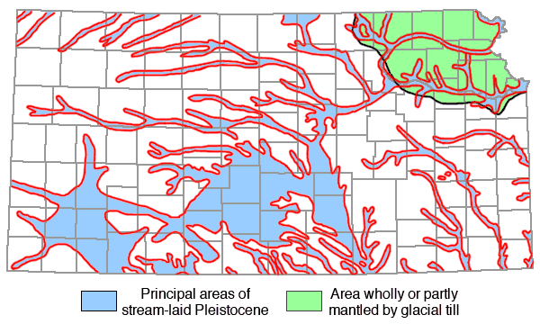
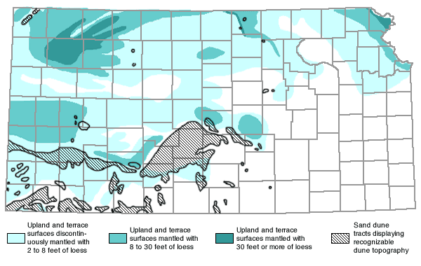
Figure 13--Distribution of eolian Pleistocene deposits in Kansas (adapted from Frye and Leonard, 1952; State Geol. Survey Kansas, 1964).
Subsurface investigations have revealed abandoned filled valleys in areas where the present surface topography is of relatively low relief. McPherson valley and Wilson valley of central Kansas, an extensive network of filled valleys in Rice County and in the area of the Great Bend sand dune tract, and the valleys in Marshall, Nemaha, Jackson, Atchison, Brown, and Doniphan counties are examples of these abandoned filled valleys (Frye and Leonard, 1952, p. 194). More than 450 feet of Quaternary deposits have been penetrated in drilling in Grant and Stanton counties. The maximum composite thickness is nearly 1,000 feet.
Pleistocene Series
Worldwide periodic climatic fluctuation was the most characteristic phenomenon of the Pleistocene Epoch. Four periods of continental glaciation and four interglacial intervals are recognized. The glaciations resulted in worldwide lowering of sea levels and cycles of erosion and deposition on the continents. At the beginning of each glaciation or glacial stage, there was a sharp reduction in both chemical weathering and soil formation and a pronounced acceleration of stream erosion. From approximately the mid-glacial to the early part of the next interglacial stage, a cycle of deposition occurred, marked by a sequence of coarse- to fine-grained sediments in the stream valleys. Deposition of glacial till and outwash material characterized the glaciated area of Kansas, and in the latter part of each glaciation, widespread deposits of eolian silts were laid down, especially adjacent to the stream valleys carrying glacial outwash.
The four interglacial stages, the Aftonian, Yarmouthian, Sangamonian, and Recent, are characterized by warmer climates and stable land surfaces in which neither erosional nor depositional processes were dominant. As a result, the interglacial periods are marked by the formation of distinct geosols (weathering profiles) that are recognizable across Kansas and parts of adjacent states. Because the geosols are time-stratigraphic markers and the climatic factors that produced them are essentially world-wide and synchronous, they serve as a basis for interregional correlation in the middle latitudes.
The Pleistocene Series is divided into eight stages in the time-stratigraphic classification now used by the State Geological Survey of Kansas (Pl. 1). Some rock-stratigraphic names previously used throughout Kansas for units of the same age but of differing mineralogical composition and source are herein restricted in usage to geographical areas. Three general sedimentary areas are proposed (Table 3), in which the rock-stratigraphic units are genetically related. Interstadial intervals (unnamed) are recognized locally within the glacial stages and permit a further division of the deposits of each glacial stage.
Till of early Nebraskan age is not recognized in Kansas; however, fluvial deposits of this age are recognized in numerous exposures in the bluffs adjacent to the Missouri River. Till of Nebraskan age has been described (Frye and Leonard, 1949, p. 887-888) in Doniphan County. At this locality an interglacial soil (Afton Soil) is developed on the uneroded surface of the till, indicating a probable late Nebraskan age for this till, since erosion or truncation had not occurred before soil development began. The name Iowa Point Till (Reed and Dreeszen, 1965) is herein adopted for this till and the exposure in NE SE sec. 6, T. 2 S., R. 20 E. in Doniphan County, Kansas, is the type locality.
Two tills of Kansan age with associated fluvial deposits and locally an interstadial soil, are present in northeastern Kansas. The older of these tills locally rests on the truncated surface of the Afton Soil and underlies the younger till and glaciofluvial deposits. The name Nickerson Till has been used for a till of similar age in Nebraska, and this term has been adopted herein for use in Kansas. The type locality is designated as a road cut in Washington County, Nebraska (Reed and Dreeszen, 1965, p. 27). The Nickerson Till is typically exposed in a gravel pit in the Missouri River bluffs adjacent to the river road 0.8 mile south of Wathena, Doniphan County, Kansas, near the center of sec. 33, T. 3 S., R. 22 E.
Till of Kansan age has been named Cedar Bluffs Till in the Platte River valley in Saunders County, Nebraska (Reed and Dreeszen, 1965, p. 32), and the name is herein adopted for use in Kansas. The Cedar Bluffs Till is typically exposed above the Nickerson Till near the center of sec. 33, T. 3 S., R. 22 E., and in a quarry in SE NW NE sec. 9, T. 5 S., R. 21 E., Doniphan County, Kansas, where a poorly developed interstadial soil underlies the Cedar Bluffs.
At some localities the Sangamon Soil formerly was considered to include an abnormally thick A-horizon and a double A-horizon at some other localities. The upper part of the thick Sangamon A-horizon or the upper Sangamon A-horizon, where a double A-horizon occurs, is now recognized as a distinct depositional unit that is younger than Sangamonian and older than the Wisconsinan Peoria Formation. This unit, which is separated from the Peoria by a weakly developed soil horizon, is named the Gilman Canyon Formation in Nebraska (Reed and Dreeszen, 1965, p. 42). It has been recognized in northeastern Kansas (Table 3) and the name is adopted herein. The Gilman Canyon Formation is typically exposed in the south bank of a draw which parallels a private road near the center of sec. 12, T. 3 S., R. 21 E., Doniphan County, Kansas.
Because Pleistocene deposits are diverse and scattered in occurrence, these geologic units are described by areas (Table 3). The sequence in which they are described in each area is from the oldest to the youngest unit. In northeastern Kansas the area glaciated by Nebraskan and Kansan glaciers is roughly bounded by the Big and Little Blue rivers on the west and by the Kansas River on the south. The southeastern area includes the remainder of eastern Kansas south of the Kansas River and east of the Flint Hills. Central and western Kansas is the largest of the three areas and includes the remainder of Kansas.
Early stratigraphic studies of Pleistocene rocks in Kansas include deposits of unconsolidated light-gray and tan silts, sands, and gravels in McPherson, Harvey, and Sedgwick counties known as the "Equus beds." These were reported as Illinoisan or younger in age by Haworth (1897). Lohman and Frye (1940) reported that although part of these deposits were Pleistocene in age, a large part of them appeared to be Pliocene in age. The "Equus beds," which occur in the central and western area (Table 3), contain bones and teeth of Quaternary horses and are an important source of ground water.
During the Nebraskan Stage a continental glacier invaded extreme northeastern Kansas. Nebraskan till and outwash deposits are less extensive than are those of the Kansan glaciation. Fluvial deposits of Nebraskan age occur locally throughout the State, but quantitatively are much less than those of the Kansan Stage.
During Aftonian time soil-forming processes were predominant and the Afton Soil probably is present over much of Kansas but is not well exposed.
Sediments of the Kansan Stage are the most widespead of the Pleistocene deposits in Kansas. During the Kansan Stage continental glaciers advanced into Kansas to a position far beyond the limits of Nebraskan ice. Fluvial deposits of Kansan age exceed in volume those of any other Pleistocene stage in Kansas. Eolian deposits of Kansan age are recognized only locally. The Pearlette ash bed, of widespread occurrence, is an important marker bed.
During the Yarmouthian Stage, like the other Pleistocene interglacial stages, climatic conditions were relatively stable and the principal geologic processes were chemical weathering and soil formation. The Yarmouth Soil is similar to the Afton Soil and Sangamon Soil, where developed under similar conditions.
During the Illinoisan Stage the continental glaciers were more remote from Kansas than in any of the other glacial stages. Fluvial deposits of Illinoisan age are quantitatively less than those in the preceding or succeeding stages.
The Sangamonian Stage (interglacial) was a time of relative climatic stability during which the principal geologic processes were weathering and soil formation. The Sangamon Soil is well developed, is exceptionally well preserved, and is found in all parts of the State.
The Wisconsinan, youngest of the four major glacial stages, constitutes the surface material over much of Kansas. These deposits are better preserved and more extensively exposed at the surface than older Pleistocene deposits. Multiple advances and retreats (stades) during the Wisconsinan resulted in the deposition of alluvium in the valley areas and loess in the upland areas.
Sedimentary deposits formed since the disappearance of the last continental ice sheet from North America, approximately 5,000 years ago, are classed as belonging to the Recent Stage. These deposits are chiefly fluvial, but they include some loess and dune sand. The U.S. Geological Survey recently adopted the term "Holocene" in preference to the term "Recent." They conclude that Holocene should have series rank equal to that of the Pleistocene. The State Geological Survey of Kansas considers Recent to be a stage of the Pleistocene.
NORTHEASTERN AREA--NEBRASKAN STAGE
DAVID CITY FORMATION
The David City Formation consists of proglacial deposits. Locally derived gray and brown chert and limestone gravel containing some arkosic material make up the lower part of the formation. Gray and brown clay, silt, and sand, compose the upper part. It is recognized only in Atchison, Brown, and Doniphan counties. The thickness ranges from 0 to 15 feet.
IOWA POINT TILL
The Iowa Point Till comprises unsorted clay, silt, sand, gravel, cobbles, and boulders. It is calcareous except in the upper weathered zone. The thickness is 30 feet or less.
Fluvial deposits.--These are water-laid silt and clay, with some sand and gravel. Where the Iowa Point Till is absent, these deposits cannot be differentiated from the David City Formation. The maximum observed thickness is about 10 feet.
Loess.--These deposits consist of eolian silt exposed in very restricted areas adjacent to the Missouri River valley. Locally the loess contains gastropods. The maximum thickness is about 10 feet.
NORTHEASTERN AREA--AFTONIAN STAGE
AFTON SOIL
The Afton Soil has a well-developed profile. It is dark gray on till or fluvial deposits in poorly drained conditions and red under well-drained conditions in loess. The thickness may be as much as 15 feet.
NORTHEASTERN AREA--KANSAN STAGE
ATCHISON FORMATION
The Atchison Formation is a proglacial deposit which is not recognizable beyond the limits of Kansan glaciation. It is composed of fine-grained sand and silt and locally gravel at the base. The upper part is thinly laminated. Similar deposits occur between the Cedar Bluffs and Nickerson tills. The maximum known thickness is nearly 100 feet, but it is commonly less than 40 feet thick.
NICKERSON TILL
This till is composed of clay, silt, sand, gravel, and boulders. Erratics are less common than in the Cedar Bluffs Till. The Nickerson is dark-gray to very dark-gray except in the upper few inches to few feet where it is weathered to a brown or reddish-brown color. It is the most extensive till sheet in Kansas. One and possibly two weakly developed interstadial soils of Kansan age are recognized locally. The maximum thickness of the Nickerson Till is 40 feet, but it is commonly less than 20 feet thick.
Fluvial deposits.--These are outwash materials consisting of silt, sand, gravel, and boulders occurring between the Cedar Bluffs and the Nickerson tills. The maximum thickness is 40 feet, but it is commonly less than 20 feet thick.
CEDAR BLUFFS TILL
The Cedar Bluffs is till, which locally contains some lenses of sorted sand and gravel. Erratics are more common in the Cedar Bluffs than in the Nickerson Till, and it is generally more deeply weathered. It is commonly brown or reddish-brown clay, but locally it contains gray or light-gray clay. The maximum thickness probably exceeds 100 feet, but it is generally less than 40 feet in thickness.
"Nortonville clay."--The "Nortonville clay" (Frye and Leonard, 1952, p. 81) is present at the top of the Cedar Bluffs Till. This clay occurs at the upland level and is believed to be an accretion gley deposited in shallow depressions on the surface of the newly formed till plain. The thickness is as much as 40 feet.
Fluvial deposits.--These are clay, silt, sand, and gravel adjacent to major stream valleys. Locally the Pearlette ash bed occurs in these deposits. The thickness is commonly 20 to 60 feet.
Loess.--Discontinuous eolian silt deposits occur in the bluffs adjacent to the Missouri River valley. Deposits of loess of this age are not recognized elsewhere. They are generally less than 10 feet thick.
NORTHEASTERN AREA--YARMOUTHIAN STAGE
YARMOUTH SOIL
This unit consists of eroded remnants of a fossil soil commonly developed in till of Kansan age. The till has been deeply oxidized, with a caliche accumulation at the base. The dark A-horizon is generally missing. The Yarmouth Soil may be 10 or more feet thick.
NORTHEASTERN AREA--ILLINOISAN STAGE
Fluvial deposits.--These deposits consist of silt, sand, and gravel underlying an intermediate terrace level. They are discontinuous in smaller drainage basins. Locally, silts in the upper part resemble loess and probably are the valley equivalent of the Loveland loess found in the uplands. The maximum thickness is about 90 feet.
LOVELAND FORMATION
This formation comprises eolian silt (loess), having a reddish-brown or yellowish-brown color. Where unleached it is calcareous and contains gastropods. The maximum thickness is rarely more than 20 feet along the Missouri River valley; elsewhere it is generally thin and discontinuous.
NORTHEASTERN AREA--SANGAMONIAN STAGE
SANGAMON SOIL
The Sangamon Soil includes a dark-gray to grayish-brown A-horizon and a thick reddish-brown B-horizon containing some caliche in the lower part. The Sangamon Soil profile is thick and well developed adjacent to the Missouri River valley, where it may be as much as 24 feet thick. It is thinner to the west. It may be developed in Loveland loess or in older material.
NORTHEASTERN AREA--WISCONSINAN STAGE
Early Wisconsinan fluvial deposits.--These deposits consist of silt, sand, and gravel. They are generally not exposed in northeastern Kansas because they are below stream levels and are overlain by deposits of late Wisconsinan and Recent ages. They may be as much as 50 feet thick.
GILMAN CANYON FORMATION
This formation occurs locally in northeastern Kansas above the Sangamon Soil and below the Peoria Formation. The lower part is light-gray to nearly white, displaying faint bedding. Deposition occurred in local depressions under moist or swampy conditions. The upper part is dark-gray, silty clay generally representing the A1-horizon of an accretion gley. It is 2 to 4 feet in thickness.
PEORIA FORMATION
Buff eolian silt (loess) comprises the Peoria Formation. It mantles the upland areas in much of northeastern Kansas and locally contains gastropods. It is as much as 100 feet thick adjacent to the Missouri River valley, but thins rapidly away from the river.
BRADY SOIL
This is an interstadial soil (geosol) locally present below the Bignell Formation in the Missouri River bluffs where it consists of a few feet of leached gray silt, grading downward into a more compact faint reddish-buff silt containing large caliche nodules.
Late Wisconsinan fluvial deposits.--These deposits are composed of clay, silt, sand, and gravel derived in part from local glacial materials. They are generally not separable from similar early Wisconsinan deposits. They underlie a low terrace position in the principal valleys. They may be as much as 50 feet thick.
BIGNELL FORMATION
The Bignell Formation, which is made up of eolian silt (loess), occurs as discontinuous deposits along the Missouri River valley. The maximum thickness is 35 feet, and it thins rapidly away from the valley.
SOUTHEASTERN AREA--NEBRASKAN STAGE
Fluvial deposits.--These deposits consist of sand and chert gravel in a noncalcareous, brownish-red clay that occurs in dissected high terrace positions along some of the present streams and across divides locally. The thickness is commonly less than 20 feet.
SOUTHEASTERN AREA--AFTONIAN STAGE
AFTON SOIL
The Afton Soil is not definitely identified in this area, but it may be part of a complex soil developed throughout several stages of the Pleistocene in local upland areas.
SOUTHEASTERN AREA--KANSAN STAGE
Fluvial deposits.--These deposits consist of sand and gravel underlying a high terrace in the major stream valleys. They are principally chert gravels derived locally from Paleozoic rocks. The distinctive Pearlette ash bed occurs locally. The maximum thickness is 50 feet, but it is generally less than 30 feet thick.
SOUTHEASTERN AREA--YARMOUTHIAN STAGE
YARMOUTH SOIL
This unit is not definitely identified in this area. Locally a soil in high terrace positions may include soil developed during the Yarmouthian Stage.
SOUTHEASTERN AREA--ILLINOISAN STAGE
Fluvial deposits.--These deposits consist of silt, sand, and gravel, underlying an intermediate terrace level in the major valleys. The gravel is principally chert and limestone derived from Paleozoic rocks. The maximum thickness is 40 feet, but it is commonly about 20 feet thick.
LOVELAND FORMATION
This formation is not definitely recognized in this area. It may mantle some of the upland area, where it may be included in a modern soil.
SOUTHEASTERN AREA--SANGAMONIAN STAGE
SANGAMON SOIL
The Sangamon Soil includes a dark-gray to grayish-brown A-horizon and a reddish-brown B-horizon. It may be represented in part by a complex soil developed during Yarmouthian and Sangamonian time.
SOUTHEASTERN AREA--WISCONSINAN STAGE
Early Wisconsinan fluvial deposits.--These deposits consist of clay, silt, sand, and gravel. They are locally separable from late Wisconsinan deposits, which are physiographically lower. The gravel is composed principally of chert and limestone derived from Paleozoic rocks. These deposits can be differentiated from late Wisconsinan deposits by means of the fossils they contain. They may be as thick as 30 feet.
PEORIA FORMATION
The Peoria Formation, which consists of eolian silt (loess), has a maximum thickness of about 10 feet. It mantles much of the upland area where locally all of it may be included in the modern soil.
BRADY SOIL
This soil is not definitely identified in this area, but it is probably included within the modern soil in the uplands and may be represented in the principal valleys by a buried soil developed in deposits in a low terrace position.
Late Wisconsinan fluvial deposits.--These deposits are clay, silt, sand, and gravel derived principally from Paleozoic rocks. The gravel is chiefly composed of chert and limestone fragments. These deposits are generally not separable from similar early Wisconsinan deposits. They may be as much as 30 feet in thickness.
BIGNELL FORMATION
The Bignell is a discontinuous eolian silt (loess), which has been incorporated into the modern soil.
CENTRAL AND WESTERN AREA--NEBRASKAN STAGE
HOLDREGE FORMATION
This formation is composed of sand and gravel occurring as fill in abandoned valleys or locally as dissected high terrace deposits adjacent to the major stream valleys. The maximum thickness is in excess of 125 feet, but it is commonly about 35 feet thick.
FULLERTON FORMATION
The Fullerton comprises clay, silt, and sand, in part derived from Pliocene deposits, but locally containing much material from Paleozoic and Mesozoic bedrock. The thickness is commonly less than 25 feet.
[Hibbard (1958) has used the term "Ballard Formation" for deposits of Nebraskan and Aftonian ages in Meade County. The Ballard includes the Angell Member below and the Missler Member above.]
CENTRAL AND WESTERN AREA--AFTONIAN STAGE
AFTON SOIL
Eroded remnants of the Afton Soil occur in the central and south-central part of the State. In far western Kansas a complex soil developed on Ogallala deposits (Pliocene) probably includes the Afton Soil.
CENTRAL AND WESTERN AREA--KANSAN STAGE
GRAND ISLAND FORMATION
The Grand Island Formation consists of silt, sand, and gravel. In south-central Kansas these occur as sheetlike deposits laid down by coalescing streams. In the central and north-central part of Kansas, the Grand Island underlies a prominent terrace adjacent to the major streams. In the western and northwestern part of the State these deposits underlie a dissected terrace adjacent to major streams. These deposits range in age from early Kansan to late Kansan. The "McPherson Formation" in McPherson, Harvey, and Sedgwick counties and the "Belleville Formation" in Republic County are in part equivalent to the Grand Island, and the "Abilene conglomerate" in Dickinson and Clay counties may be of this age. The maximum thickness is 80 feet, but it is more commonly 20 feet in thickness.
SAPPA FORMATION
This unit consists of alluvial silt and some sand. In south-central Kansas sheetlike deposits laid down by coalescing streams are present. In northern and central Kansas these deposits underlie a prominent terrace adjacent to the principal stream valleys. In northwestern Kansas these deposits underlie a dissected terrace adjacent to the major streams. Locally the Sappa contains the distinctive Pearlette ash bed. The thickness is commonly 20 feet.
[Hibbard (1949) used the term "Crooked Creek Formation" for deposits of Kansan and Yarmouthian ages in Meade County. The formation comprises the Stump Arroyo Member overlain by the Atwater Member, which includes the Pearlette ash bed (Hibbard, 1958).]
CENTRAL AND WESTERN AREA--YARMOUTHIAN STAGE
YARMOUTH SOIL
Poorly exposed soil identified as Yarmouth is present locally. In this area a buried soil on eroded Ogallala below a cover of Wisconsinan loess shows evidence of multiple cycles of soil development that probably include the Yarmouth Soil.
CENTRAL AND WESTERN AREA--ILLINOISAN STAGE
CRETE FORMATION
This formation is composed of silt, sand, and gravel. In larger valleys the gravel is primarily arkosic, reflecting derivation from Pliocene and older Pleistocene rocks, but in some tributary valleys the deposits may be derived almost entirely from the Paleozoic and Mesozoic bedrock. Silts in the upper part of the formation that resemble loess are probably the valley equivalent of the Loveland Formation that occurs in the uplands. The thickness may be as much as 60 feet, but it is commonly about 40 feet thick.
LOVELAND FORMATION
The Loveland Formation comprises yellowish-brown or reddish-brown silt (loess). The thickest deposits are in north-central Kansas where they may exceed 40 feet in thickness. Southward and westward the deposits thin and become discontinuous.
[Hibbard (1958) applied the term "Kingsdown Formation (restricted)" to deposits of Illinoisan and Sangamonian ages in Clark County.]
CENTRAL AND WESTERN AREA--SANGAMONIAN STAGE
SANGAMON SOIL
The Sangamon Soil is best developed in north-central and northwestern Kansas. It is characterized by its reddish-brown color in north-central and southwestern Kansas; in northwestern Kansas it is pale reddish-brown in color.
CENTRAL AND WESTERN AREA--WISCONSINAN STAGE
Early Wisconsinan fluvial deposits.--These deposits are composed of silt, sand, and gravel. In northwestern Kansas they are not generally exposed. In south-central Kansas these deposits underlie the higher of two low terraces. The gravel in northwestern Kansas is derived from Pliocene and older Pleistocene arkosic deposits; in south-central Kansas it is derived from Paleozoic and Mesozoic deposits. The thickness may be as much as 30 feet.
PEORIA FORMATION
The Peoria Formation (formerly Peoria silt member) comprises pale yellowish-buff to light-gray eolian silt (loess) that mantles most of the upland areas in the central and western part of the State. The formation is as much as 90 feet thick in northwestern Kansas, but it is commonly 20 to 30 feet thick. In central Kansas it is 10 feet or less in thickness.
BRADY SOIL
The Brady Soil is generally more maturely developed than the modern soil and is dark gray in the upper part, grading into a grayish-brown zone containing small caliche nodules. It is widespread, but it is discontinuous in the uplands of northwestern Kansas below the Bignell Formation. In south-central Kansas the Brady is identified only in alluvial deposits.
Late Wisconsinan fluvial and eolian deposits.--Silt, sand, and gravel of late Wisconsinan age underlie a low terrace in most valleys. Gravel in major stream valleys is derived principally from Pliocene and older Pleistocene arkosic deposits, but in some tributary valleys it is derived from Paleozoic and Mesozoic deposits.
Deposits of wind-laid sand (dunes) are widespread in south-central Kansas and in western Kansas south of the Arkansas River. The dunes may attain a thickness of 50 feet, or more commonly, 20 feet.
BIGNELL FORMATION
Loess deposits of the Bignell Formation are widely distributed in northwestern Kansas but are thin and discontinuous in central Kansas. They are generally less than 10 feet thick.
[Hibbard (1949) proposed the name "Vanhem Formation" for deposits of Wisconsinan and Recent ages in Clark County.]
RECENT STAGE
Fluvial deposits.--These deposits consist of clay, silt, sand, and gravel and are the sediments in and along the active channels of streams. Recent sediments comprise deposits on the floodplain and on the upper part of some low terraces. The lithology and mineralogy of Recent fluvial deposits in each stream valley reflect the source materials provided to the drainage basin. The thickness of Recent fluvial deposits is not well documented, but probably ranges from 0 to about 40 feet in the various stream valleys.
Loess.--Thin, discontinuous deposits of loess of Recent age are present over parts of Kansas. Generally these deposits are incorporated into the modern soil.
Dune sand.--These deposits are composed of fine-grained eolian sand and are most extensive adjacent to the Cimarron River, the Arkansas River, and locally in the Republican River valley. The dunes are largely stabilized; however, in those areas where they are most extensive, some active dunes are present.
Previous Page--Mesozoic || Next Page--Igneous and Metamorphic
Kansas Geological Survey, Stratigraphic Succession in Kansas
Comments to webadmin@kgs.ku.edu
Web version August 2005. Original publication date Dec. 1968.
URL=http://www.kgs.ku.edu/Publications/Bulletins/189/10_ceno.html