Kansas Geological Survey, Bulletin 187, Part 3, originally published in 1967
Originally published in 1967 as Kansas Geological Survey Bulletin 187, Part 3. This is, in general, the original text as published. The information has not been updated.
The Elgin sandstone, a unit in the Kanwaka Shale (Virgilian, Upper Pennsylvanian), crops out in south-central Kansas. Distribution of the Elgin, which ranges from 0 to 180 feet in thickness, indicates that it was deposited in a shallow-marine to marginal-marine environment controlled by the distributary pattern of a large delta complex. Major source of the material for the clastic wedge was from the south in the Arbuckle-Ouachita Mountain area. Distribution of the Elgin Sandstone seemingly was not influenced by the algal limestone buildups f the underlying Plattsmouth Limestone Member of the Oread Limestone, although the basal shales of the Kanwaka reflect the presence of these buildups.
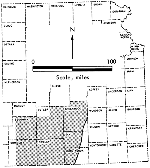
Shallow-marine, cyclical shelf deposits of Virgilian (Late Pennsylvanian) age in Kansas grade southward into predominantly continental, deltaic, clastic sediments of equivalent age in north-central Oklahoma. The area of maximum change in south-central Kansas provides critical evidence on the relationship of these interfingering sediments (Fig. 1). Of particular interest in this area are: (1) the presence of large sandstone bodies, (2) the pinching out of limestones, and (3) abnormally thick limestones. The purpose of this paper is to delineate and map one of the large sandstone bodies, the Elgin sandstone, to determine its depositional environment, and to establish the relationship of the Elgin clastics to abnormally thick limestone buildups in the underlying Plattsmouth Limestone Member of the Oread Limestone.
Figure 1--Index map of eastern Kansas showing location of study area. Elgin sandstone crops out along eastern edge of stippled area.
Little detailed work has been done on the Elgin sandstone, which occurs in the Kanwaka Shale in Kansas. Most references to this part of the Shawnee Group are incidental to more general studies of the rock sequence in Kansas or to studies of specific geographic areas. Sandstones within the "Lecompton" shales (Kanwaka Shale of present usage) have been called the "Elgin sandstone" because of their extraordinary development near Elgin, Kansas (Haworth, 1898, p. 64). However, the name was used only locally in Kansas (Verville, et al., 1958). Many geologists apply the term in Oklahoma, where the Elgin is classified as a formation (Beckwith, 1930). On the geologic map of Oklahoma, the Elgin is shown as a member of the Vamoosa Formation (Miser, 1954) (Table 1).
Table 1--Stratigraphic classification of Shawnee rocks in southern Kansas and equivalent rocks in north-central Oklahoma (modified from Jewett, 1959; Branson, 1957).
| South-central Kansas | North-central Oklahoma | ||||
|---|---|---|---|---|---|
| Virgilian Stage |
Shawnee Group |
Topeka Limestone |
Pawhuska Formation |
Turkey Run Limestone Member |
|
| Little Hominy Limestone Member |
|||||
| Calhoun Shale |
|||||
| Deer Creek Limestone |
Deer Creek Limestone Member |
||||
| Tecumseh Shale |
|||||
| Lecompton Limestone |
Lecompton Limestone Member |
||||
| Kanwaka Shale |
Elgin sandstone |
Vamoosa Formation |
Elgin Sandstone Member |
||
| Oread Limestone |
Plattsmouth Limestone Member |
Oread Limestone |
|||
| Heebner Shale Member |
|||||
| Leavenworth Limestone Member |
|||||
| Snyderville Shale Member |
|||||
| Toronto Limestone Member |
|||||
In the subsurface many sandstones of the Kanwaka Shale have been identified as the Elgin, Elgin-Hoover, upper Hoover, and Peacock. Lukert (1949, p. 140) states, ". . . the Elgin sandstone is correlated with the sandstones which occur in a shale on the Oread limestone. This shale is considered to be the Kanwaka formation. This conclusion agrees with that of Murray 14 [1946] who has traced the Elgin sandstone on the surface from southern Osage County northward into Kansas." Jordan (1957) defines the Elgin in the subsurface of Oklahoma as the lower of two sandstones in the Shawnee Group between the Deer Creek Limestone and Oread Limestone; the two sandstones collectively are called "Hoover sandstone."
Electric and radioactivity logs along with sample logs were used to determine limits of different stratigraphic units. These data were checked with subsurface cross sections (both electric and sample log) compiled by other investigators (Lukert, 1949; Kansas Geological Society, 1956; Adkison, 1963) and sample logs of the Kansas Sample Log Service. The Elgin was examined at outcrops in Chautauqua and Elk counties, and surface data were used to supplement and verify subsurface information.
All data collected were processed by computer to give structural tops, thicknesses, lithologic ratios, and stratigraphic unit ratios (Brown, 1966). Outcrop bands on all figures and plates are taken from the Geologic Map of Kansas (1964). Locations of subsurface data points are shown on Plate 2, A.
I wish to thank H. A. Ireland and E. J. Zeller, of the Department of Geology, The University of Kansas, for critically reviewing this report. Special thanks are extended to D. F. Merriam, who suggested the problem and showed continued interest in the work. Thanks are due J. M. Jewett, P. H. Heckel, and W. L. Adkison for their assistance, and L. R. Brown, who wrote the computer programs used in this study. Computing facilities were furnished by The University of Kansas Computation Center.
[Note: Based on a Master of Science thesis submitted to the Department of Geology, The University of Kansas, 1966.]
The Elgin sandstone and adjacent units belong to the Shawnee Group of the Virgilian Stage, Upper Pennsylvanian Series. The units investigated are the Oread Limestone and the overlying Kanwaka Shale with the included Elgin sandstone.
[Note: "Elgin sandstone" is used informally as a unit in the Kanwaka Shale (which is at least a partial equivalent of the Vamoosa Formation of Oklahoma). Although the term "Elgin" is not shown on the rock chart of the State Geological Survey of Kansas (Jewett, 1959), it was listed in the Survey's "The Kansas Rock Column" (R.C. More, et al., 1951) and in the U.S. Geological Survey's "Lexicon of Geologic Names of the United States, 1936-1960" (G.C. Keroher, et al., 1966). Inasmuch as this study is not directly concerned with the nomenclature of this unit, no discussion of the problem is included herein.]
The Oread, basal formation of the Shawnee Group, includes four limestone members and three shale members in eastern Kansas, which are in ascending order, the Toronto Limestone, the Snyderville Shale, the Leavenworth Limestone, the Heebner Shale, the Plattsmouth Limestone, the Heumader Shale, and the Kereford Limestone. In south-central Kansas the Kereford and Heumader are not recognized (Table 1). Only the Plattsmouth Limestone was studied in detail.
The Plattsmouth of northern Kansas typically consists of 10 to 20 feet of light-gray, wavy-bedded, fossiliferous, chert-bearing limestone. The fossils include fusulinids, corals, bryozoans, brachiopods, echinoids, and crinoids. The thickness and lithologic character of the Plattsmouth in southern Kansas is uniform except for the local development of algal buildups, which comprise the upper 29 feet near Rogers Station (CE2 sec. 26, T. 33 S., R. 10 E.) west of Sedan, Chautauqua County. Solitary caniniid corals and the colonial tabulate Syringopora are characteristic fossils in south-central Kansas below the algal development.
The isopachous map of the Plattsmouth Limestone Member (Pl. 2, A) shows local buildups of limestone trending northeastward across Sumner, Cowley, and Elk counties. Examination of surface exposures and of well samples reveals that they are both composed of algal material. Cross sections A-A' and B-B' (Pl. 1) show the stratigraphic relationships of the algal development.
The three members of the Kanwaka are, in ascending order, the Jackson Park Shale, the Clay Creek Limestone, and the Stull Shale. These have not been identified on the surface south of T. 30 S., and it is impossible to recognize them in the subsurface throughout most of the area studied. In south-central Kansas a sandstone sequence, the Elgin, is present within the Kanwaka.
The shales of the Kanwaka differ greatly laterally and vertically both in thickness and physical characteristics. Because of poor field exposures, only a general description of the Kanwaka, based on cable-tool samples, is given here. Most of the shales are varicolored--gray, gray-green, brown, red-brown, and yellow-brown. Where the Elgin sandstone is present, the shales are generally brown and gray. Pyrite, mica, and organic fragments are common accessory constituents. Marine fossils, mostly fusulinids, brachiopods, and gastropods and other mollusks, are rare. Distribution and thickness of the Kanwaka Shale are shown in Plate 2, B. The formation thins abruptly northwestward in Sumner County, with marked thinning of the Elgin sandstone. The Kanwaka also thins in the area of the Plattsmouth Limestone buildups northwest of Winfield in Cowley County.
The Elgin generally is a light-gray to yellowish-gray, very fine- to fine-grained, friable, subangular to subrounded, well sorted, thin- to thick-bedded, quartzose sandstone. The weathered rock is generally light brown to reddish-brown. Mica, pyrite, and fragments of organic material are locally abundant. Glauconite was found in the lower part of the unit in the Lowell and Holl No. 1 Olson well in sec. 13, T. 35 S., R. 7 E., Cowley County. Brachiopods, pelecypods, gastropods, and, less commonly, crinoids and bryozoans preserved as casts and molds, were found in many surface exposures in Chautauqua and Elk counties. Crossbedding and ripple marks are common. The Elgin consists of interbedded siltstones, shales, and sandstones that grade vertically and horizontally into the enclosing shale. The ratio of sandstone to shale decreases northwestward as the Elgin thins (Pl. 2, C).
The Elgin sandstone ranges from 0 to 180 feet in thickness and generally is about 100 feet thick (Pl. 2, C). It thins abruptly to the northwest in Sumner and Cowley counties and thins gradually in the northeastern part of the study area. The lowermost sandstone is the thickest and most extensive sandstone lens of the Elgin. The cross sections (Pl. 1) show the stratigraphic relationships of the sandstones.
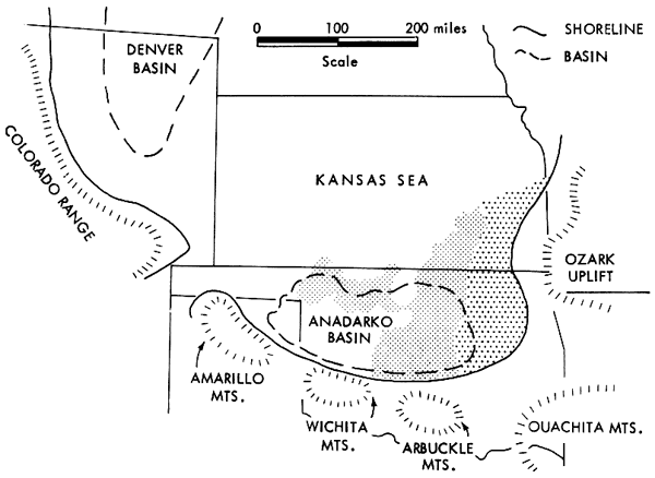
Major late Paleozoic structural features, the Sedgwick Basin, the Nemaha Anticline, and the Cherokee Basin, were inactive during deposition of the Kanwaka Shale. Deposition of shale and sandstone occurred in a shelf area north of the Anadarko Basin (Fig. 2). A major sediment source lay to the south in the Arbuckle and Ouachita mountains, and another of minor importance was to the east in the area of the Ozark Uplift (Greig, 1959; Tanner, 1959).
Figure 2--Distribution of Elgin sandstone in relation to paleogeography, (modified from Elias, 1964; Rascoe, 1962). Widely spaced pattern shows present distribution of Elgin; closely spaced pattern shows postulated distribution of Elgin.
Present structure is that of the Prairie Plains Homocline of post-Permian age, which dips west at approximately 25 feet per mile from the Ozark Uplift (Prosser and Beede, 1904). Evidence of post-Shawnee movement of the Nemaha Anticline is shown by reversal of dips in younger beds.
Deposition of the Plattsmouth Limestone and lower shales of the Kanwaka was similar to deposition of Lansing units as described by Harbaugh (1959, p. 326): ". . . reefs or banks lay seaward from the land areas, and the intervening submerged areas were lagoonlike . . . organic limestones accumulated on a submerged coastal plain or shelf unhindered by arrival of much clay and sand. When drainage on land began to supply more terrestrial material, a new series of land-derived deposits was built out over the old drowned shelf, gradually restricting the area of limestone accumulation and ultimately covering it."
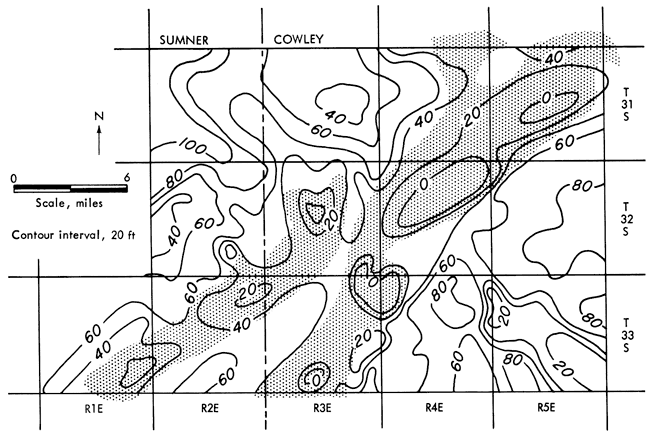
Kanwaka deposition was initiated at a time when the supply of clastics from the south increased. The limestone buildups of the Plattsmouth probably continued to accumulate while the lower Kanwaka shales were being deposited. As the supply of clastics increased, however, marine-bank growth was restricted. The first influx of fine clastics filled up the irregularities of the submarine surface (Fig. 3) so that when Elgin deposition was initiated, a relatively flat surface existed. Thus, the Oread topographic surface had little influence on subsequent deposition of the Elgin.
Figure 3--Isopachous map of shale in lowermost Kanwaka Shale, showing thinning of unit over limestone buildups (shaded area) in Plattsmouth Limestone Member of Oread Limestone in Sumner and Cowley counties.
Similarity of the Elgin sandstone to Recent deltaic sandstones in Louisiana described by Fisk (1955, 1961) suggests that it was deposited in a shelf-deltaic environment like that of the Mississippi River delta. Fisk has shown that thin, lenticular sand and silt bodies underlie principal river distributaries in the Mississippi River delta. These sandstone bodies, called "bar fingers" by Fisk, mark the long-continued seaward lengthening of the branches of the major drainage system entering the depositional basin (Fig. 4). Characteristics of bar-finger sands, according to Fisk (1961, p. 50), are:
Figure 4--Distinguishing geometric and sedimentary characteristics of bar fingers (modified from Fisk, H. N., 1961, Geometry of Sandstone Bodies, fig. 9, p. 49. Reproduced by permission of American Association of Petroleum Geologists, Tulsa, Oklahoma).
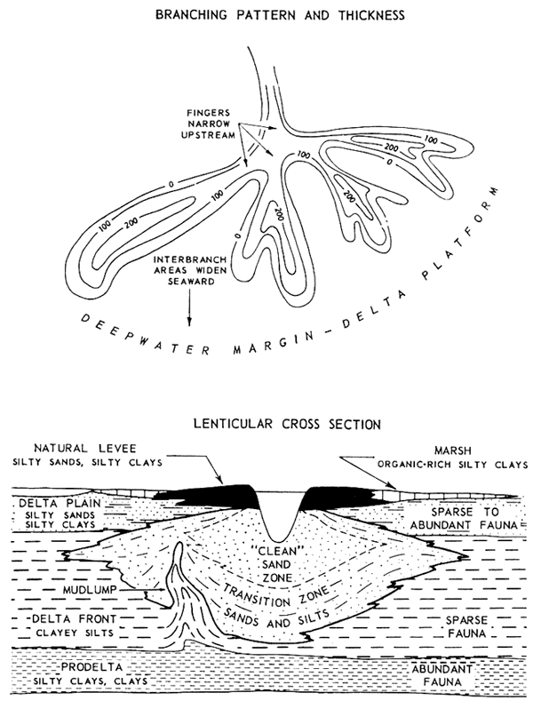
Bar fingers develop in response to progressive seaward building of distributary-mouth bars (shallow-water features located a mile or more offshore from distributary mouths), and the settling of the bar sand mass in the delta front muds. Thus, the fingers would have the same general grain size and sorting characteristics as do present bar deposits and also would exhibit the branching pattern of the deltaic stream distributary complexes (Fisk, 1955, 1961; Fisk, et al., 1954).
Sands swept from the distributary-mouth bars are formed into bars, spits, and beaches by waves and currents. Most of the suspended load is carried beyond the mouth of the distributaries to settle along the delta front or farther offshore in the prodelta zone. The bar fingers of sand and silt would continue to accumulate and extend across the delta front of clays and silts, thus building the delta seaward (Fisk, 1961).
Most of the characteristics of the distributary-mouth bars and bar fingers associated with deltaic sedimentation as listed by Fisk are exhibited by the Elgin sandstones. These sands are very fine to fine grained, well sorted, clean, largely unfossiliferous, and gradational within the enclosing more fine-grained deposits. Siltstones, where present, are usually found in the lower part of the sandstone body in a manner similar to that shown in Figure 4. The isopachous map of the Elgin sandstone (Pl. 2, C) displays this deltaic shape.
The isopachous map of the Elgin also shows the finger-like patterns resembling distributary drainage, but this pattern is masked on the Kanwaka thickness map because of variation in thickness of the shales. The sandstone bodies are elongate and widen and thicken in the distal parts of the branches. The sandstones pinch out abruptly to the west and thin gradually to the north. Sands were probably swept from the west and spread to the north by longshore currents.
The Kanwaka Shale and the included Elgin sandstone were deposited by northward- and westward-flowing streams on the northern shelf extension of the Anadarko Basin (Fig. 2). A major source area was the Arbuckle and Ouachita mountains to the south, and a secondary source was the Ozark Uplift to the east. The postulated shoreline in relation to Elgin deposition is shown in Figure 2. Any land north and northeast of south-central Kansas was probably too low or too distant to furnish much terrigenous sediment. As the influx of clastics decreased and the seas transgressed southward, the area was again farther from shore and sandstone deposition gave way to shale deposition for the remainder of Kanwaka sedimentation.
The Elgin sandstone exhibits sedimentary features characteristic of marine sand bars and of the branching pattern associated with deltaic sedimentation. The Elgin deposits accumulated in a shallow-marine to marginal-marine environment as governed by the distributary pattern of a delta. Thus, sandstone bodies of the Elgin are identified as bar-finger sands.
Deposition of the Kanwaka Shale and the Elgin sandstone in south-central Kansas resulted from seaward building of a delta onto the northern shelf extension of the Anadarko Basin. Rivers flowed into the sedimentary basin carrying material from the Arbuckle and Ouachita mountains to the south and from the Ozark Uplift to the east. Land to the north was either too low or too distant to supply sediment.
The Plattsmouth Limestone was deposited on a shelf, with development of algal carbonate banks probably paralleling the shore. The lowermost shales of the Kanwaka accumulated simultaneously with development of the algal banks, but by the time of deposition of the Elgin sandstone, fine clastics had settled into the limestone banks, terminating the growth of the organisms that formed them. Therefore, the irregular submarine topography at the top of the Plattsmouth did not have a major role in deposition of the Elgin.
Studies of the "Layton sandstone" (Schulte, 1959) and the "Stalnaker sandstone" (Winchell, 1957) show the same general characteristics and distribution of sand as those shown for the Elgin. This suggests that other sandstone units of the Upper Pennsylvanian Series in Kansas were formed as a result of similar sedimentary controls.
Adkison, W. L., 1963, Subsurface geologic cross section of Paleozoic rocks from Butler County to Stafford County, Kansas: Kansas Geol. Survey, Oil and Gas Invest. no. 28, 90 p. [available online]
Beckwith, H. T., 1930, Osage County: Oklahoma Geol. Survey, Bull. 40, v. 3, p. 211-267.
Branson, C. C., 1957, Oklahoma facies of Kansas formations: Kansas Geol. Soc., 21st Field Conf. Guidebook, p. 92-104.
Brown, S. S. L., 1966, General stratigraphy and depositional environment of the Elgin sandstone in south-central Kansas: unpubl. Master of Science thesis, Dept. Geol., Univ. Kansas, 52 p.
Elias, M. K., 1964, Depth of Late Paleozoic Sea in Kansas and its megacyclic sedimentation; in Symposium on cyclic sedimentation, D. F. Merriam, ed.: Kansas Geol. Survey, Bull. 169, v. 1, p. 87-106. [available online]
Fisk, H. N., 1955, Sand facies of Recent Mississippi delta deposits: 4th World Petroleum Cong. (Rome), Proc., Sec. I-C, p. 377-398.
Fisk, H. N., 1961, Bar-finger sands of Mississippi delta; in Geometry of Sandstone Bodies, J. A. Peterson and J. C. Osmond, eds.: Am. Assoc. Petroleum Geologists, Tulsa, p. 29-52.
Fisk, H. N., McFarlan, E., Jr., Kolb, C. R., and Wilbert, J., Jr., 1954, Sedimentary framework of the modern Mississippi delta: Jour. Sed. Petrol., v. 24, no. 2, p. 76-99.
Greig, P. B., 1959, Geology of Pawnee County, Oklahoma: Oklahoma Geol. Survey, Bull. 83, 188 p.
Harbaugh, J. W., 1959, Marine bank development in Plattsburg Limestone (Pennsylvanian), Neodesha-Fredonia area, Kansas: Kansas Geol. Survey, Bull. 134, pt. 8, 43 p. [available online]
Haworth, Erasmus, 1898, Stratigraphy of the Kansas coal measures: Kansas Univ. Geol. Survey, v. 3, 347 p.
Jewett, J. M., 1959, Graphic column and classification of rocks in Kansas: Kansas Geol. Survey, chart.
Jordan, Louise, 1957, Subsurface stratigraphic names of Oklahoma: Oklahoma Geol. Survey. Guidebook 6, 220 p.
Kansas Geological Society, 1956, Cross sections, southeastern Kansas: Kansas Geol. Soc., Wichita, cross section (2 sheets).
Keroher, G. C., and others, 1966, Lexicon of Geologic Names of the United States for 1936-1960: U.S. Geol. Survey, Bull. 1200, Pt. 1, p. 1-1448.
Luckert, L. H., 1949, Subsurface cross sections from Marion County, Kansas, to Osage County, Oklahoma: Am. Assoc. Petroleum Geologists, Bull., v. 33, no. 2, p. 131-152.
Miser, H. D., 1954, Geologic map of Oklahoma: U.S. Geol. Survey and Oklahoma Geol. Survey, map.
Moore, R. C., Frye, J. C., Jewett, J. M., Lee, Wallace, and O'Connor, H. G., 1951, The Kansas rock column: Kansas Geol. Survey, Bull. 89, 132 p. [available online]
Murray, A. N., 1946, Field guide for Pennsylvanian and Permian rocks along OK. 20 between Fairfax and a point about eight miles east of Hominy, Oklahoma: Oklahoma City Geol. Soc., Field Trip, Nov. 14-15, 1946, pt. 2, p. 7-9.
Prosser, C. S., and Beede, J. W., 1904, Description of the Cottonwood Falls quadrangle, Kansas: U.S. Geol. Survey Geol. Atlas, Folio 109, 6 p., 2 maps.
Rascoe, Bailey, Jr., 1962, Regional stratigraphic analysis of Pennsylvanian and Permian rocks in western Mid-continent, Colorado, Kansas, Oklahoma, Texas: Am. Assoc. Petroleum Geologists Bull., v. 46, no. 8, p. 1345-1370.
Schulte, G. S., 1959, The Cottage Grove and Noxie sandstones ("Layton") in south-ccntral Kansas: Kansas Geol. Soc., 24th Field Conf. Guidebook, p. 101-106.
State Geological Survey of Kansas, 1964, Geologic Map of Kansas: Map M-1.
Tanner, W. F., 1959, Permo-Pennsylvanian paleogeography of part of Oklahoma: Jour. Sed. Petrol., v. 29, no. 3, p. 326-335.
Verville, G. J., Jewett, J. M., Kulstad, R. O., Plummer, Norman, Schoewe, W. H., Goebel, E. D., and Bayne, C. K., 1958, Geology, mineral resources and ground-water resources of Elk County, Kansas: Kansas Geol. Survey, v. 14, 56 p. [available online]
Winchell, R. L., 1956, Relationship of the Lansing Group and the Tonganoxie ("Stalnaker") Sandstone in south-central Kansas: Kansas Geol. Survey, Bull. 127, pt. 4, p. 123-152. [available online]
Kansas Geological Survey, Geology
Placed on web Oct. 9, 2008; originally published in Aug. 1967.
Comments to webadmin@kgs.ku.edu
The URL for this page is http://www.kgs.ku.edu/Publications/Bulletins/187_3/index.html