Kansas Geological Survey, Bulletin 127, part 4, originally published in 1957
Originally published in 1957 as Kansas Geological Survey Bulletin 127, part 4. This is, in general, the original text as published. The information has not been updated.
The "Stalnaker sand," known in the subsurface of southern Kansas as an oil and gas producing zone, is the Tonganoxie sandstone of eastern Kansas outcrops. Evidence is presented in this report that upholds this correlation and disproves the idea that the "Stalnaker" is a facies of the Lansing group. The lithologic difference between the "Stalnaker" and the Lansing is not the result of contemporaneous deposition of different facies but is the result of erosion of the Lansing and deposition of the Tonganoxie ("Stalnaker") sandstone in the erosional depressions and basins left after post-Missourian erosion.
Purpose and scope of investigation.-The purpose of this report is to present an explanation of the relationship between Lansing limestones and the "Stalnaker sand," which occurs in the subsurface throughout most of south-central Kansas. This sandstone is especially worthy of study because it is productive of oil and gas in many parts of southern Kansas. Unlike subsurface sand bodies that have been labeled shoestring sands, this sand body is in part persistent and sheet-like.
The "Stalnaker sand" can be traced from the subsurface to the outcrop in eastern Kansas, where it is known as the Tonganoxie sandstone. Its base represents the contact of the Missourian and Virgilian Series of the Pennsylvanian System. Evidence is outlined in this report to support these conclusions.
Owing to the importance of the "Stalnaker" as an oil and gas zone, its subsurface relations have received much attention, which has resulted in two opposing ideas: (1) The "Stalnaker" is a facies of the Lansing group, or (2) it is the basal sandstone of the Virgilian Series, equivalent to the Tonganoxie sandstone.
A regional disconformity occurs at the base of the Virgilian Series throughout Kansas. In many places along the outcrop, the Tonganoxie sandstone rests on this erosional surface in contact with rocks of both the Pedee and Lansing groups.
Lins (1950) states that in northeastern Kansas the Tonganoxie rests disconformably upon members of the Lansing group down to and including the Captain Creek member of the Stanton limestone. The same relation is possible and entirely probable in the area included in this study.
Although Lins' work points to stream erosion and deposition of the Tonganoxie in northeastern Kansas, the sheet-like distribution of the equivalent sand body in part of south-central Kansas points to subaerial and subaqueous erosion and near-shore marine deposition of at least part of the sand.
Strata belonging to the Douglas and Lansing groups crop out in southeastern Kansas along a southwest-trending belt through Greenwood, Wilson, Elk, Montgomery, and Chautauqua counties (Fig. 1). Surface study was confined to the area from T. 27 S. to T. 35 S. and from R. 12 E. to R. 17 E.
Figure 1--Index map showing location of area discussed in this report in relation to post-Mississippian structural provinces.
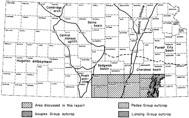
The Douglas and Lansing groups, as well as groups above and below, were studied in the subsurface over an area of approximately 7,500 square miles, from T. 27 S. to T. 35 S. and from R. 17 E. to R. 10 W. (Fig. 1). The area includes Wilson, Montgomery, Chautauqua, Elk, Cowley, Sumner, and Kingman counties, the southern part of Greenwood, Butler, and Sedgwick counties, and eastern Barber County.
Surface exposures of the Douglas and Lansing groups in Wilson and Montgomery counties were examined and measured. Geologic sections were constructed by use of lithologic, electric, and radioactivity logs, and measured surface sections were correlated with subsurface sections. Structure contour maps and isopachous maps were drawn to develop additional information and concepts.
The "Stalnaker sand" is first mentioned by Ley (1924), who said: "A zone of sandstones is generally reported immediately above the Lansing Limestones. . . . the horizon can be carried south to the Oklahoma line. It probably represents the contact of the Lansing and Douglas groups." The first use of the name "Stalnaker" is by Kesler (1928), who mentions the "Stalnaker sand" as the producing zone in the Churchill and Oxford fields. Subsequent oil and gas bulletins of the Kansas Geological Survey mention the "Stalnaker" as a producing zone. Bass (1929, p. 116) contrasts the sheet-like distribution of the "Stalnaker" with the Cherokee shoestring sands. He also suggests that the "Stalnaker" was deposited in a marine body of water. Rich (1931) mentions the Churchill and Oxford fields as: ". . . interesting variation from the general rule in that the principal accumulation is in sands near the middle of the Pennsylvanian section." He also states that the base of the "Stalnaker sand" is the contact of the Lansing and Douglas groups. Lukert (1949) was the first to suggest in print that the "Stalnaker" of the subsurface can be correlated with the Tonganoxie sandstone on the surface.
H. A. Ireland, University of Kansas, J. R. Berg, University of Wichita; W. L. Stryker, Consulting Geologist; and The Atlantic Refining Company provided technical assistance in this study.
Rocks of the Lansing and Douglas groups were studied in detail along outcrops in Wilson and Montgomery counties. The following description of these groups was prepared from surface exposures and well samples. Plate 1 shows variations in thickness and lithology in a composite outcrop section across Wilson and Montgomery counties. Locations of the individual sections are presented in the Appendix. A generalized section (Fig. 2) is presented to show the stratigraphic position of beds included in this report.
Figure 2--Generalized section showing stratigraphic position of beds discussed in this report.
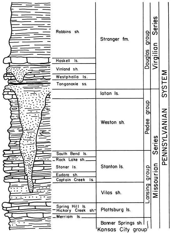
Moore (1951) defines the Lansing group as including three formations, in ascending order, the Plattsburg limestone, the Vilas shale, and the Stanton limestone. The thickness of this group averages about 85 feet, but in parts of southern Kansas it is as much as 140 feet.
The Lansing group, composed mostly of resistant limestone, forms an escarpment that can be traced across most of eastern Kansas but which is not present in southern Montgomery County, where the limestones have thinned and in some places grade into thin sandstones. The shale members of the Lansing thicken considerably, as is shown by section 28 of Plate 1. This change is fairly abrupt in central Montgomery County and causes difficulty in tracing the individual members of the group south of Independence.
Although rocks of the Lansing group are recognized easily in the subsurface throughout eastern and central Kansas, they have not been separated from limestones of the Kansas City group in the subsurface of western Kansas, where they are combined and called the Lansing-Kansas City groups. The formations of the Lansing group have been identified in sample logs, but no attempt was made to subdivide the formations into members in the subsurface.
Plattsburg Limestone
The Plattsburg formation overlies the Bonner Springs shale, of the Kansas City group, and underlies the Vilas shale. It comprises, in ascending order, the Merriam limestone, Hickory Creek shale, and Spring Hill limestone members.
The Plattsburg is very irregular and ranges in thickness from 1 foot to about 80 feet in Wilson and Montgomery counties. This variation in thickness in relatively short distances may possibly be attributed to the development of algal reef-like bodies. The formation is characterized by abundance of the sponges Girtyocoelia and Heliospongia.
Examination of samples shows the Plattsburg in the subsurface to consist of dark-brown to gray or white, compact to coarsely crystalline, locally oölitic, fossiliferous limestone containing brachiopod fragments, crinoid columnals, and scattered fusulinids. In most places one to three members are present. The thickness ranges from a featheredge to 53 feet in south-central Kansas.
Merriam limestone member--The Merriam is a blue-gray, blocky, finely crystalline limestone, which weathers yellow and platy. The fossils found in this member include Osagia, abundant sponges, crinoid columnals, fenestrate and ramose bryozoans, brachiopods, and pelecypods.
McManus (1956) describes the Merriam at the type locality as two limestone beds separated by a thin shale bed, but in Wilson and Montgomery counties the Merriam is represented by a single limestone bed averaging 1 foot thick and in few places more than 2 feet thick in northern Montgomery County. McManus correlates this bed with the upper unit of the Merriam farther north.
Hickory Creek shale member--The Hickory Creek shale is the middle member of the Plattsburg formation. In Wilson and Montgomery counties, this member is 3 to 40 feet thick. It is blocky, calcareous, light brown to gray, and weathers yellowish, and where thick, contains thin interbedded plates of shaly limestone. The unit is characterized by the abundance of fossil sponges that weather out on the surface.
Spring Hill limestone member--The Spring Hill limestone is blue gray, wavy bedded, finely crystalline, and weathers yellow brown. Its thickness ranges from a featheredge to 83 feet in Wilson and Montgomery counties, and where thickest, the limestone is light gray, somewhat shaly, and algal, indicating possible reef development. Fossils include abundant sponges, crinoid columnals, fenestrate and ramose bryozoans, and locally, horn corals, brachiopods, and gastropods. At one locality in sec. 8, T. 28 S., R. 17 E., Wilson County, a large nautiloid cephalopod was found.
Vilas Shale
The Vilas shale as redefined by Moore (1932) contains no members and is the middle formation of the Lansing group. The Vilas shale was named by Adams (1898, p. 96); the type locality is near the town of Vilas, Wilson County, Kansas (section 4, Appendix).
The Vilas consists of brownish to olive to greenish-gray silty shale, locally calcareous. Limonite concretions may be found near the middle of this unit. Locally, a thin algal bed is present about 1 foot from the top. This limestone contains the fossil algae Osagia, as well as crinoid columnals and mollusks. The Vilas generally is unfossiliferous, but in the shale separating the algal limestone from the overlying Stanton formation, a microfaunal assemblage contains the ostracodes Bairdia and Kirkbya (?), unidentified fusulinids, and several other foraminifera including Polytaxis and Tetrataxis (Wagner and Harris, 1953). Also present are echinoid spines, crinoid columnals, bryozoans, and mollusks.
Of all rock units in the Lansing group, the Vilas shale displays the greatest range in thickness. Within Wilson County it ranges from 7 to 110 feet.
In the subsurface, the Vilas consists chiefly of light- to dark-gray shale and some interbedded red shale. The shale is fissile and micaceous, locally sandy and fossiliferous. The thickness ranges from 10 to 100 feet.
Stanton Limestone
The Stanton limestone was defined by Haworth and Bennett (1908) as including beds from the top of the Vilas shale to the base of the Weston shale of the Pedee group. It is composed of five members, the Captain Creek limestone, Eudora shale, Stoner limestone, Rock Lake shale, and South Bend limestone, in ascending order.
In the subsurface the Stanton is predominantly limestone, and in most places it grades downward from white, compact to finely crystalline, soft limestone to dark-brown, coarsely crystalline limestone. Fossils include crinoid columnals, brachiopod fragments, and locally fusulinids and ostracodes. The limestone is also locally oölitic. Its thickness ranges from a featheredge to 105 feet, and one to five members are recognized.
Captain Creek limestone member--The Captain Creek is a blue-gray to light-gray limestone, which weathers whitish and vuggy. It is compact to fine grained, massive, even bedded, and in most exposures has vertical fractures. Its thickness ranges from 10 to 27 feet in Wilson County and to 40 feet locally in Montgomery County. Where thickest in Montgomery County it is reef-like (section 25, Appendix).
In southern Montgomery County this limestone thins and questionably may be traced to the Oklahoma border, where its thickness ranges from 2 to 5 feet. It is light gray, oölitic, and locally sandy.
Eudora shale member--In northeastern and east-central Kansas the Eudora shale is a distinctive marker bed consisting principally of black fissile shale. In Wilson and Montgomery counties the member loses this distinctive appearance and consists mostly of olive-gray to gray clay shale. It is silty and slightly calcareous. Locally it contains one or more thin, shaly, light-brown to gray, fine-grained limestone beds. The lowermost portion is unfossiliferous, but the upper portion contains scattered fragments of bryozoans, crinoids, and mollusks. The thickness ranges from 1 to 6 feet in Wilson County and northern Montgomery County.
Stoner limestone member--The Stoner limestone forms a prominent escarpment in Wilson County and northern Montgomery County. It consists of light-gray limestone, which weathers yellow. It has mostly thin wavy beds and is easily mistaken for the Spring Hill member of the Plattsburg limestone. It is very fine grained and blotchy but contains irregularly distributed large calcite crystals. It is locally oölitic. The fauna consists of brachiopods, fenestrate bryozoans, and crinoid columnals. Crinoid calices are present on bedding planes in the quarry south of Fredonia. Its thickness ranges from 3 to 20 feet in Wilson County and northern Montgomery County, but the member may be absent in southern Montgomery County.
Rock Lake shale member--This member generally is absent in Wilson and Montgomery counties, but where present it consists of about 2 feet of olive-gray clay shale. Locally it is sandy or calcareous and fossiliferous. Seemingly it rests disconformably on the Stoner. It contains sandstone at outcrops north of Wilson County. Sandstone is present in some places in the subsurface below the topmost bed of the Stanton. It is white, fine grained, calcareous, compact, and distinct from other sandstones in the Pennsylvanian section. It produces oil and gas in the Brinegar field in Greenwood County. In the subsurface of eastern Kansas it is known as the "Buxton sand," but it is not the equivalent of the Weston shale, which once was called the Buxton formation (Moore, 1936).
South Bend limestone member--Good exposures of the South Bend member are extremely difficult to find in Wilson and Montgomery counties. The member consists of reddish-brown, medium-grained, porous, sandy limestone or limy sandstone, weathering to sandy red soil (W. L. Stryker, personal communication). Wagner (1953) describes a conglomeratic phase at the base of the member from exposures near Fredonia, Wilson County. The South Bend is 2 to 15 feet thick.
The Pedee group, named by Moore (1932), is defined as including the rocks above the Stanton formation; it marks the top of the Missourian Series. It is composed of two formations, the Iatan limestone above and the Weston shale below.
In Wilson and Montgomery counties the group consists only of the Weston shale; the Iatan is absent throughout the area. This limestone unit has evidently been removed by post-Missourian erosion, for there is a marked disconformity at the top of the Pedee group.
Weston Shale
In Wilson and Montgomery counties this unit consists of blue-gray to yellowish-brown, fissile clay shale containing ironstone concretions near the middle part. Fossils are lacking. In southern Montgomery County the shale contains beds of thin, even-bedded sandstone. The thickness of the unit ranges from 12 to 162 feet. This variation is probably the result of post-Missourian erosion.
In the subsurface the Weston is gray, fissile, micaceous shale containing some interbedded sandstone. It is unfossiliferous and ranges in thickness from 40 to 170 feet.
The Douglas group, as named and defined by Moore (1932), includes beds from the post-Missourian disconformity to the base of the Oread limestone and is the lowermost part of the Virgilian Series. The Douglas group is composed of the Lawrence (upper) and Stranger (lower) formations.
Stranger Formation
The base of the Stranger formation is marked by the post-Missourian disconformity, and the top by the base of the Ireland sandstone member of the Lawrence shale. The formation includes the Tonganoxie sandstone, Westphalia limestone, Vinland shale, Haskell limestone, and Robbins shale, in ascending order.
Tonganoxie sandstone member--This member was defined by Newell (1935). It is a sandstone deposited in channels, which in places were eroded through the Pedee group down to the Captain Creek member of the Stanton limestone. The type locality is east of Tonganoxie, Leavenworth County.
The Tonganoxie sandstone persists throughout Wilson and Montgomery counties, and where massive, it forms noticeable escarpments. The rocks that have been assigned to the Tonganoxie in these counties include two distinct lithologic types, which may or may not be of contemporaneous deposition. (1) The first type is a thin-bedded shaly sandstone or sandy shale and siltstone, which grades downward into the Weston shale where a disconformity is not readily observable (Wagner and Harris, 1953). (2) The second type is a massive cross-bedded sandstone that lies disconformably on older rocks. This is the channel sandstone known in northern Kansas outcrops. Wagner (1953) describes a limestone conglomerate that occurs at the base of this massive sandstone. The sandstone is reddish brown to buff, fine to medium grained, and composed of well-sorted, subangular quartz grains. It is micaceous and locally cross bedded. The thickness ranges from 20 to 50 feet. It is rock of this latter type that is herein discussed as "Stalnaker" or Tonganoxie.
Where massive sandstone is lacking, a sequence of shales, sandy shales, shaly sands, and siltstones is present. These units are thin bedded and yellowish gray to greenish gray. The thickness ranges from 50 to 80 feet.
The massive sandstone phase of the Tonganoxie is equivalent to the "Stalnaker sand" of the subsurface. Lithologically they are similar. The sand found in sample examination is brown to light gray, fine grained, well sorted, subangular, and micaceous. No fossils were found in the "Stalnaker." A coarser-grained zone occurs at the base of the "Stalnaker," which may correspond to the conglomerate known on the surface. Lukert (1949), from a sample examination, found 'Unevenly sized, light-colored, weathered chert fragments at the base of the "Stalnaker." He offers this as additional evidence of the disconformable contact of the "Stalnaker sand" upon lower beds. An isopachous map of the "Stalnaker" is presented as Plate 2A.
The name "Stalnaker sand" was derived from the Stalnaker farm in southern Sumner County. On April. 20, 1914, a well drilled by B. B. Jones in the NW corner SE sec. 11, T. 35 S., R. 2 E., was completed as a gas well having an initial production of 7 million cubic feet. The producing zone was a sand zone found at a depth of 2,380 feet, which was named "Stalnaker sand." Although it never produced gas from the "Stalnaker" commercially, this well was the incentive for additional drilling nearby. The Empire Gas and Fuel. Company No. 1 Horton well, in the NE NW sec. 15, T. 35 S., R. 2 E., drilled a year later, produced gas from the Severy shale and opened the North Vernon field. Another well in this field, the Tidal Oil Company No. 1 Horton in the SE corner sec. 17, T. 35 S., R. 2 E., recovered oil from the "Stalnaker" at a depth of 2,331 feet. Total recovery was only 821 barrels and the zone was abandoned (Kesler, 1928).
The "Stalnaker" and Tonganoxie equivalent in Oklahoma is the "Tonkawa sand." This name originated in the Tonkawa field in T. 24 and 25 N., R. 1 W., Noble and Kay counties, Oklahoma. The "Tonkawa sand," which produces in this field, can be traced easily by electric logs into Kansas and correlated with the "Stalnaker sand" (Lukert, 1949).
Westphalia limestone member--The Westphalia is composed of two distinct limestone units. The basal unit is a single thick bed, brown to brownish gray, weathering yellow brown. The limestone contains the algae Osagia and abundant fusulinids. The top unit is thin bedded and light gray, weathering yellow. The total thickness ranges from 1 to 5 feet.
The Westphalia is recognizable in the subsurface but occurs only locally; its thickness ranges from a featheredge to 40 feet. For purposes of correlation in this report, the Westphalia is combined with the Haskell limestone to form a unit collectively called the Haskell.
Vinland shale member--The Vinland consists of greenish-gray, calcareous, blocky clay shale. The shale is marine and contains many fossils, including abundant fusulinids in the upper 6 inches. The thickness of this unit ranges from 6 feet in northern Wilson County to as much as 24 feet in southern Montgomery County.
Haskell limestone member--The Haskell limestone, although relatively thin, is one of the most persistent beds in the Stranger formation, both on the surface and in the subsurface. On surface exposures in Wilson and Montgomery counties, this limestone is bluish gray to brown and weathers yellow. It is very fine grained, hard, and thin bedded. The thickness ranges from 1 to 6 feet. The limestone contains brachiopods, crinoid columnals, scattered fusulinids, and Cryptozoan.
This rock unit was traced into the subsurface of south-central Kansas, where it was found to be the limestone that occurs so persistently just above the Tonganoxie sandstone. It also can be traced into western Kansas, where it is known as the "Brown lime."
Sample examination shows the Haskell limestone to be dark brown to tan, fine to medium crystalline, and locally oölitic and fusulinid bearing. The thickness in the subsurface ranges from 3 to 10 feet.
The surface beds were traced westward into the subsurface in order to determine which bed correlated with the "Stalnaker sand." It was found that the thin limestone bed that persistently caps the "Stalnaker" was stratigraphically too high to be the South Bend member of the Lansing group or the Iatan member of the Pedee group. In addition, the Iatan member is not present on the surface in southern Kansas, and this study indicates that it is absent in the subsurface.
It also was noticed that in places in the subsurface two thin limestone beds occurred 1 to 10 feet apart in the interval above the "Stalnaker." These limestones were traced to the surface outcrops of the Haskell and Westphalia limestones. This correlation agrees with that of Lukert (1949), but he questionably called the lower limestone the Westphalia. There is little doubt that this bed is the Westphalia, for it is in the same stratigraphic position in the subsurface and on the surface and is fusulinid bearing in the subsurface as on the surface. Both the Haskell and the "Stalnaker" give a distinctive "kick" on electric logs and are easily picked.
The relationship between the Lansing and the "Stalnaker" has been thought to be a facies change, because in south-central Kansas the "Stalnaker" occupies the stratigraphic interval of the Lansing. The Lansing and "Stalnaker" definitely were not deposited contemporaneously, for in tracing the interval from east to west along the line of cross section BB' (Plate 3), it was determined that the interval between the Haskell and the Lansing decreases and the "Stalnaker sand" lies close beneath the Haskell and Westphalia and above the Weston shale. The decrease in interval results from wedging out of the shales of the Weston formation between the "Stalnaker" and the Lansing as the result of truncation by post-Missourian erosion. Therefore, the "Stalnaker" is contemporaneous with the Tonganoxie sandstone of surface outcrops.
There is possibly a difference in environment of deposition between the Tonganoxie of the surface and its equivalent, the "Stalnaker," of the subsurface. On the surface the Tonganoxie is called a channel sand, although many workers say this is not the case. They believe that the Tonganoxie may be occupying ancient channels but that the sand in these channels is marine and was not deposited by slow meandering streams. On the other hand, the "Stalnaker" phase is sheet-like in distribution and indicates marine deposition near shore.
The west end of cross sections AA' and BB' (Plate 3) provides additional proof that the "Stalnaker"-Lansing relationship is not a facies change. Between wells 1 to 2 of each cross section, 50 to 100 feet of Lansing limestone disappears and its place is taken by 50 to 70 feet of "Stalnaker sand." Vertically, this relation is not the normal sequence of foreland or platform cyclic deposition, which typically grades from sandstone up to sandy limestone and then to limestone, thick shales completing the sequence. This sequence is more nearly realized in the series of beds from the base of the "Stalnaker" up through the Douglas group. Between the above-mentioned wells, the lateral change is from non-sandy limestone to sandstone. There is no evidence of a facies change, which would normally be a gradation either from sandy limestone to sandstone or from limestone to shale to sandstone. Lack of evidence for a facies change indicates that the sandstone was not deposited contemporaneously with the Lansing limestone, but rather that the Lansing limestones and the shales of the Pedee group were truncated by erosion and that the "Stalnaker sand" was deposited at a later time on this erosional surface. It is coincidental that farther east in the basin the "Stalnaker" occupies the interval where the Lansing would be if present.
The evidence in this report shows that the "Stalnaker sand" of the subsurface is the equivalent of the Tonganoxie sandstone on the surface. As Tonganoxie is the name accepted by the Kansas Geological Survey, it will be used for the remainder of this report in referring to both the surface and subsurface rocks of this zone.
Southeastern and south-central Kansas is located on the Prairie Plains monocline, which dips west at a low angle on the flank of the Ozark uplift. Ley (1924) states that dip in few places exceeds 40 feet per mile. Dips as small as 25 feet per mile are not uncommon over long distances. Dips steeper than 40 feet per mile are found locally on anticlinal noses, domes, basins, and synclines of small areal extent. These small features have been described as "Plains Type Folds" by Powers (1925). Because sediments of Permian age conform to this westward dip, it is logical to assume that the tilting of the area was post-Permian.
Major structural features in the area are the Cherokee and Sedgwick basins, separated by the Nemaha anticline (Fig. 1).
The Nemaha anticline is the result of late Mississippian-early Pennsylvanian movement. This structure extends southwest across Kansas and in the area of this report is present in western Butler County, northwestern Cowley County, and southeastern Sumner County. A line drawn from T. 27 S., R. 4 E., to T. 35 S., R. 1 E., would approximate the position of its crest. The structural contour map on the Haskell limestone (Plate 2C) shows domes and anticlines as reflections of the Nemaha anticline. The more prominent of these are the Augusta anticline in T. 27 and 28 S., R. 3 and 4 E., and the Churchill dome in T. 31 and 32 S., R. 2 and 3 E. The Augusta structure shows closure of more than 150 feet, and the Churchill structure has closure of more than 200 feet. Berry and Harper (1948) give an interesting discussion of the Augusta anticline. Both of these structures are productive of oil and gas, and the Churchill pool is of particular interest because its producing zone is the Tonganoxie. Many smaller domes and anticlines, which are not shown as closed structures on the Haskell contour map, also reflect the Nemaha anticline, and also are productive. Those of interest in this report (because they produce from the Tonganoxie sandstone) are the Douglass, Udall, Weathered, and Oxford domes.
The Sedgwick basin is located west of the Nemaha anticline, the Cherokee basin to the east. Major development of the basins is post-Mississippian.
Many small structures such as anticlines, anticlinal noses, domes, basins, and synclines occur throughout south-central Kansas. These are regarded as post-Pennsylvanian structures. The closure on these structures increases with depth. The largest increases are at the major unconformities. Ley (1924) gives an interesting discussion of the origin of these folds.
Many of these small folds are apparent on the surface. Two of the more prominent ones in the area are the Augusta anticline, in Butler County (T. 27 and 28 S., R. 3 and 4 E.), and the Dexter anticline, in Cowley County (T. 33 and 34 S., R. 6 and 7 E.) Bass (1929) gives a good description of the Dexter fold. Because of the large contour interval, this anticline is not revealed on the Haskell contour map (Plate 2C).
Another well-known structure, which shows on the Lansing contour map (Plate 2B), is the Silver City dome of Wilson County (T. 27 S., R. 14 E.) Contoured on top of the Lansing at a 50-foot interval, this dome shows a closure of more than 50 feet.
Structural and isopachous maps and cross sections were used in studying the relationships between the Lansing group and the Tonganoxie sandstone. These include three stratigraphic cross sections and one structural cross section (Plate 3), an isopachous map of the Tonganoxie sandstone (Plate 2A), a structural contour map on the top of the Lansing, which also shows areal distribution of the Lansing limestones (Plate 2B), and a structural contour map on top of the Haskell limestone (Plate 2C).
Plate 2A shows the thickness and distribution of the Tonganoxie sandstone. The 100-foot contour line shows a pattern of elongated thicker sand zones extending from the mouths of the "channels." These thicker belts may occupy linear depressions on the erosional surface that collected more sand. It is conceivable that these linear depressions were extensions of the "channel" valleys across the basin before the advance of the sea.
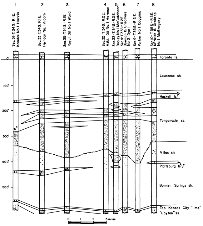
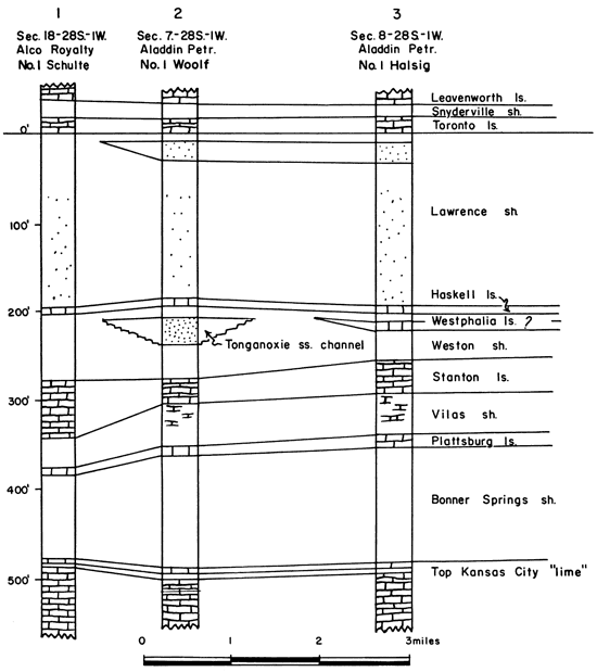
Figure 3 is a short cross section drawn to show the shape of the "Stalnaker sand" body. It was drawn through T. 34 and 35 S., R. 1 and 2 E., the region of maximum difference in sand thickness. It can be seen that the base of the major sand body is irregular, fitting the erosional surface on which the "Stalnaker" was deposited. Figure 3 also shows the presence of thinner sand lenses above the main sand body. The lenses are treated as part of the Tonganoxie sandstone, as they are thought to indicate oscillations of the sea near the end of Tonganoxie time before the deposition of Haskell limestone. Wells 2 and 3 on Figure 3 show, below the Haskell member, the limestone bed that is identified as the Westphalia.
Figure 3--Cross section showing shape of Tonganoxie ("Stalnaker") sand body.
Also shown on the isopachous map (Plate 2A) are five "channels" of Tonganoxie sandstone. The "channels" were located by the examination of all available well logs in the area. Many wells in the northern part of the area were found to contain sandstone between the Haskell limestone and the top of the Lansing. This sand was correlated with the "Stalnaker sand" farther south in the basin. Many wells in the northern part of the area contained only shale or sandy shale and no sand in this part of the section. By outlining the area containing Tonganoxie sandstone, the five "channels" were located. It is possible that these "channels" were the distributary system that carried sediment into the depositional basin to the south. Figure 4 shows a cross section across a "channel" in T. 28 S., R. 1 W., and also shows a complete section of Lansing limestones below the "channel."
Figure 4--Cross section showing a Tonganoxie sandstone channel in Sedgwick County.
Included on Plate 2A is the density of well control and symbols for the type of log from which information was obtained. It was found that the most reliable information was that from electric and radioactivity logs. Other data were obtained from logs of the Kansas Sample Log Service, drillers logs, and sample logs. Drillers logs were used with caution.
Also shown on the isopachous map are outlines of the oil fields that produce from the Tonganoxie sandstone. The Udall, Churchill, Oxford, and Weathered fields are situated on local domes along the Nemaha anticline. Oil accumulation in the Tonganoxie of the Falls City field (T. 35 S., R. 7 E.) results from a pinch out of sand on an anticlinal nose. The Bush-Denton field produced from a stratigraphic trap in the Tonganoxie sandstone. The Derby field produced oil from a depositional pinch out of the Tonganoxie sandstone. The Andover South field is unique in that it produces oil from one of the "channels."
The top of the Lansing is missing throughout most of the area, and contours could be drawn only where the top could be identified (Plate 2B). The two most notable structures on this map are the Augusta anticline (T. 27 and 28 S., R. 3 and 4 E.) and the Silver City dome (T. 27 S., R. 14 E.) Also shown is the areal distribution of the Lansing group in the area.
The northern part of the map, where structural contours are drawn on the top of the Lansing, indicates the area where the Lansing group is complete. Contours were stopped at the south boundary of this area. In the next area south, only part of the Lansing group is present. The top of the Lansing has been removed by post-Missourian erosion, and therefore contours across this area would reflect only this erosion surface and not the true structure. Tonganoxie sandstone is present above the Stanton in this area. The next boundary south indicates the southern limit of the Stanton formation. South of this line the Stanton formation has been completely removed by erosion. It is difficult to tell where the southern limit of the Lansing group as a whole has been truncated because, as is shown by cross section CC' (Plate 3), the Plattsburg limestone is irregular and in places probably disappeared by lensing out rather than by removal. This condition has allowed the Vilas formation of the Lansing group to come into contact with the Bonner Springs shale of the Kansas City group, and the two cannot be differentiated in the subsurface.
Small isolated remnants of Stanton limestone were found south of the main Stanton boundary. These areas are regarded as outliers of the Stanton limestone, and they provide additional evidence that the relationship between the Lansing limestones and the Tonganoxie sandstone is not the result of a facies change but of erosion.
In the southern part of this area, where the Stanton formation is entirely absent (with the exception of the outliers), probably much of the Vilas and Plattsburg formations also is absent. It is within this area that the Tonganoxie attains its thickest development.
The eastern area indicated on the map is the north-south belt of outcrop of the Lansing group.
Because of the persistence of the Haskell limestone and the ease with which it may be identified on electric logs, the top of this bed makes an excellent contouring horizon (Plate 2C). In the subsurface, the Haskell is an important marker bed, especially in Barber, Kingman, and Harper counties. In this area, however, miscorrelation of the Haskell, given the name "Brown lime," with the Iatan limestone or with the South Bend member of the Stanton limestone has caused much confusion. In all probability, the bed known throughout western Kansas as the "Brown lime" is actually the Haskell limestone, as in southern Kansas.
Plate 3 consists of three stratigraphic cross sections showing subsurface correlations across southern Kansas. The top of the Topeka limestone was used as a datum plane for these cross sections. Also included is a cross section showing structure along line BB'.
Cross section AA'--This cross section is drawn across the northern part of the area. It shows the unconformity between the Tonganoxie sandstone and the truncated Lansing limestones. The thin limestone bed capping the Tonganoxie sandstone is identified as the Haskell limestone of the surface. This correlation agrees with that of Lukert (1949). Well 1 shows a complete section of Lansing limestones about 220 feet thick, the Haskell limestone lying about 30 feet above the top. Well 2 shows 70 feet of Tonganoxie and slightly more than 100 feet of Lansing limestones below it. These wells are 5 miles apart. Pre-Virgilian erosion has evidently removed rocks more than 100 feet thick (we must consider that the Pedee group was once present also) within this 5-mile distance. This indicates either that the forces of differential erosion were vigorous or that the land surface was exposed to erosion for a long time.
The shape of the sand body (flat on top and convex downward on the bottom) between wells 1 and 7 indicates deposition in a shallow marine basin near shore. Wells 8, 10, and 11 penetrate this sand body and are interpreted as being located in the channels of ancient streams of Tonganoxie time.
In studying the subsurface sands of the Douglas group in northern Greenwood County, Sanders (1957) has confirmed the presence of channels of Tonganoxie sandstone. These channels can be traced southward to connect with the channels in south-central Kansas (Plate 1).
Wells 8, 9, 12, 13, and 14 show the presence of another limestone bed below the Haskell limestone. This bed has questionably been correlated with the Westphalia limestone of surface outcrop. In well 9 the member attains a thickness of about 40 feet. At no place in Kansas where the Westphalia crops out at the surface does it reach such a thickness, but it is not uncommon in the subsurface. The distribution of the Westphalia in the subsurface is very erratic, and as is seen in this cross section, the thickness ranges from a featheredge to 40 feet.
At no place in this cross section does the Tonganoxie cut completely through the Lansing group. Well 5 shows no limestone beneath the sand, but this is due to the Plattsburg's limestones having lensed out. Thus Vilas shale was allowed to come in contact with the Bonner Springs shale. (Note the position of the Mississippian "lime" in well 6. Its high position is a reflection of the Nemaha anticline under this well.)
Cross section BB'--This cross section is drawn across the southern part of the area, as indicated on the index map. Wells 1 and 2 show the same truncation of the Lansing limestones as does the western end of cross section AA'.
The width of the depositional basin of the Tonganoxie sandstone increases from approximately 55 miles in cross section AA' to about 115 miles along this section. Well 15 is located in another of the supposed Tonganoxie "channels". Wells 3, 4, and 6 seem to show sand occupying the complete Lansing interval, indicating that erosion has removed the entire Lansing section. The Westphalia limestone member does not appear in this cross section.
Cross section XY is presented to illustrate the present attitude of the strata used in correlation. It was constructed by plotting the logs used in cross section BB' on sea level datum. The regional dip of the area averages about 30 feet per mile.
Cross section CC'--This stratigraphic cross section is a north-south section. It intersects cross section AA' at well 4 and BB' at well 7. All or part of the Plattsburg limestone is present in wells 1 to 5, but south of well 5 the unit seems to be missing, whether as a result of nondeposition or erosion is not known. The Westphalia member appears about 10 feet below the Haskell member in well 5.
South-central and southeastern Kansas long have been known for their oil and gas production, for it was in this area that the first oil and gas fields of Kansas were discovered. Jewett (1954) gives an interesting account of the early development.
Throughout the area there are many oil and gas producing zones, which range in age from late Cambrian to late Pennsylvanian. A list of these would include such producers as Arbuckle (Cambro-Ordovician), Simpson and Viola (Ordovician), Mississippian, and Pennsylvanian basal conglomerate, Cherokee, Marmaton, Kansas City, and Lansing of Pennsylvanian age. Many "stray" sandstones of Pennsylvanian age are prolific producers. These include the "Burgess", "Bartlesville", "Squirrel", "Weiser", "Redd", "New Albany", "Wayside", "Peru", "Layton", "Cleveland", Tonganoxie ("Stalnaker"), "Hoover", and "Peacock". For the purpose of this report, discussion of oil and gas production is limited to that from the Tonganoxie ("Stalnaker") sandstone.
Economic products of the Tonganoxie sandstone are oil, gas, and helium. Nine fields produce from this zone. The most famous of these is the Churchill field , in Sumner County. Other Tonganoxie fields are the Andover South (Butler County), the Falls City, Udall, and Weathered fields (Cowley County), The Bush-Denton field (Elk County), the Derby field (Sedgwick County), and the Oxford and Vernon North fields (Sumner County). Location of these fields is shown on Plate 2A.
The Andover South field is almost unique in that it produces gas from a "channel" of Tonganoxie sandstone (Plate 2A) on the west flank of the Augusta anticline. The Bush-Denton field is an interesting variation of Tonganoxie production. Here the sand occupies a re-entrant channel or drowned valley, which is bordered and underlain by impervious shales and limestones of the Lansing group not removed by erosion. The sand was originally thought to be a new zone, but it was later correlated with the "Stalnaker" and is now known to be Tonganoxie.
A well in sec. 24, T. 33 S., R. 10 E., (Glidden No. 1 Holroyd), drilled in 1925, was reported to have a production of 5 to 6 million cubic feet of helium from the Tonganoxie. This well is located within the Peru-Sedan field where the sand is approximately 60 feet thick. The gas produced from the Tonganoxie sandstone in other fields within the general area is known to contain minor amounts of helium.
The Udall, Weathered, Oxford, and Churchill fields are located on domes along the axis of the Nemaha anticline. The Churchill dome shows the most relief of any of these structures. The contours drawn on the Haskell limestone (Plate 2C) show this dome to have a closure exceeding 200 feet. The Tonganoxie sandstone is thinner at the top of the dome than it is on the flanks. Until recent years, all oil from this field was produced from the Tonganoxie; to the end of 1955, the 16 wells in this field had produced nearly 20 million barrels of oil from this zone (Goebel and others, 1956, p. 215). Rich (1931) has given his views concerning the source and reason for accumulation of oil in these granite ridge pools. He points out that wells drilled into Mississippian and Ordovician rocks in the Churchill and Oxford fields have produced only water. These same formations are productive in other fields. He therefore concludes that the oil in the Tonganoxie ("Stalnaker") sandstone of these pools has migrated from deeper formations by extensive fissures and has been trapped in the sands. The original source bed of the oil, according to Rich, was either the Chattanooga shale or the Cherokee shale.
Initially the research on this problem was based on the conception that the relationship between the "Stalnaker sand" and the Lansing group was a facies difference. The only evidence to support this theory was the fact that the "Stalnaker" occupies the stratigraphic interval that usually includes the Lansing limestones. The thin, persistent limestone bed known to occur 1 to 30 feet above the "Stalnaker" throughout central Kansas was an important element for consideration. If the "Stalnaker" was a facies of the Lansing, this thin persistent limestone should be one of the limestones of the Lansing group. The study of this problem showed that such was not the case. The study also revealed several other points of interest, each of which added more to disprove the "facies theory." The following list summarizes these lines of evidence:
The evidence shows that the "Stalnaker" of the subsurface is the Tonganoxie sandstone of eastern Kansas outcrops.
Adams, G. I., 1898, Physiography of southeastern Kansas: Kansas Univ. Quart., v. 7, p. 87-102.
Bass, N. W., 1929, The geology of Cowley County, Kansas: Kansas Geol. Survey, Bull. 12, p. 1-203. [available online]
Berry, G. F., Jr., and Harper, P. A., 1948, Augusta field, Butler County, Kansas: Am. Assoc. Petroleum Geologists, Structure of typical American oil fields, v. 3, p. 213-224.
Goebel, E. D., and others, 1956, Oil and gas developments in Kansas during 1955: Kansas Geol. Survey, Bull. 122, p. 142-233.
Haworth, E., and Bennett, J., 1908, Special report on oil and gas: Kansas Univ. Geol. Survey, v. 9, p. 1-586.
Jewett, J. M., 1954, Oil and gas in eastern Kansas: Kansas Geol. Survey Bull. 104, p. 1-397.
Kesler, L. W., 1928, Oil and gas resources of Kansas in 1927: Kansas Geol. Survey, Min. Res. Circ. 1, p. 1-60.
Lee, Wallace, and Merriam, D. F., 1954, Cross sections in eastern Kansas: Kansas Geol. Survey, Oil and Gas Investi. 12, p. 4.
Ley, Henry, 1924, Subsurface observations in southeast Kansas: Am. Assoc. Petroleum Geologists Bull., v. 8, p. 445-453.
Lins, T. W., 1950, Origin and environment of the Tonganoxie sandstone in northeastern Kansas: Kansas Geol. Survey, Bull. 86, pt. 5, p. 105-149. [available online]
Lukert, L. H., 1949, Subsurface cross sections from Marion County, Kansas, to Osage County, Oklahoma: Am. Assoc. Petroleum Geologists Bull., v. 33, p. 131-152.
McManus, Dean, 1956, Stratigraphy of the Upper Pennsylvanian Merriam limestone in eastern Kansas: Kansas Univ., unpublished master's thesis, 105 p.
Moore, R. C., 1932, A reclassification of the Pennsylvanian System in the northern Midcontinent region: Kansas Geol. Soc., Guidebook 6th Ann. Field Conf., p. 79-98.
Moore, R. C., 1936, Stratigraphic classification of the Pennsylvanian rocks of Kansas: Kansas Geol. Survey, Bull. 22, p. 124-153.
Moore, R. C., 1949, Divisions of the Pennsylvanian System in Kansas: Kansas Geol. Survey, Bull. 83, p. 72-81. [available online]
Moore, R. C., and others, 1951, The Kansas rock column: Kansas Geol. Survey, Bull. 89, p. 63-99. [available online]
Newell, N. D., 1935, The geology of Johnson and Miami counties, Kansas: Kansas Geol. Survey, Bull. 21, p. 70-82. [available online]
Powers, Sidney, 1925, Structural geology of the Mid-continent region--A field for research: Geol. Soc. America, Bull., v. 36, p. 379-392.
Rich, J. L., 1931, Source and date of accumulation of oil in Granite Ridge pools of Kansas and Oklahoma: Am. Assoc. Petroleum Geologists Bull., v. 15, p. 1431-1452.
Sanders, D. T., 1957, Sandstones of the Douglas and Pedee groups as possible ground-water reservoirs in northeastern Kansas: Kansas Univ., unpublished master's thesis, 47 p.
Wagner, H. C., 1953, Geology of the Fredonia quadrangle: U. S. Geol. Survey, GQ 49.
Wagner, H. C., and Harris, L. D., 1953, Stratigraphy of outcropping rocks of the Fredonia quadrangle: U. S. Geol. Survey, Oil and Gas Investi. Chart OC 48.
Listed on the following pages are sections measured at outcrops of Douglas and Lansing rocks in Wilson and Montgomery counties, Kansas. These sections are presented in graphic form on Plate 1.
Kansas Geological Survey, Lansing Group and the Tonganoxie ("Stalnaker") Sandstone, South-central Kansas
Placed on web Feb. 16, 2009; originally published in Dec. 1957.
Comments to webadmin@kgs.ku.edu
The URL for this page is http://www.kgs.ku.edu/Publications/Bulletins/127_4/index.html