![]()
Prev Page--Introduction || Next Page--Geography, continued
Geography
Topography and Drainage
Seward County lies entirely within the High Plains section of the Great Plains physiographic province. The principal part of the county consists of a slightly rolling upland plain, largely obscured by sand dunes in the southern half and traversed by the valley of Cimarron River from the northwestern corner to the southeastern corner.
The surface of Seward County slopes almost imperceptibly from the western border of the county to the southeastern corner. The highest point on the upland has an altitude of about 2,950 feet and the lowest point on the upland of about 2,680 feet. The slope of the upland, therefore, is about 11.1 feet to the mile toward the east and the southeast. The plain is of low relief, as is demonstrated by its typical statement in the northeastern quarter of the county. The upland hills are only slightly above the general surface of the plain and slope gently downward to the wide shallow basins that lie between them. Only in a few places, except for the areas immediately adjacent to Cimarron Valley, is the upland plain invaded by established drainage lines, these being long tributaries of the Cimarron. The surface runoff of the true upland, seemingly, is in the form of sheet wash, there being no evidence of gullying apparent in the soft materials underlying the upland. A part of the precipitation falling on the uplands descends as sheet wash to the low points of the upland surface where it collects in shallow pools. Because of the clayey character of the upland soil in many places, these pools may persist for some time after precipitation has ceased. The playas so formed have been called "buffalo wallows," although their association with buffaloes would seem a coincidental rather than a casual one. The imperviousness of the soil underlying a "wallow" may be in part due to the sheet wash transportation to the lowest part of the shallow basin of the very finest particles available on the gentle tributary slopes.
The typical upland plain topography is largely obscured in the southern half of the county except for an occasional "window" that shows through the concealing sand dunes. The upland sand dunes exhibit at least three magnitudes of statement as surface features. Most extensive are the dunes of low elevation that may be distinguished from the non-sandy upland surface only by their slightly hummocky topography. The sand in these areas contains a large admixture of silt, has a fairly well-developed soil profile, and can support "row crops." The dunes of the second type are less extensive, less silt is mixed in with the sand, and the hummocky topography is developed in moderate relief. The most typical sand dunes are those of the third type, actively blowing at the present time in many places. Such dunes project conspicuously above the otherwise subdued surface and constitute some of the highest points in the county. Dunes of the intermediate type support a good stand of scrub vegetation, but are not readily adapted to cultivation. The high dunes are only poorly protected by a thin covering of vegetation and resume their migration when the vegetal cover has been breached. A typical migrating dune is shown in Plate 5.
The several types of upland dunes exhibit what seems to be a consistent relationship to one another. Dunes of intermediate magnitude lie within more extensive areas of subdued dunes and the high dunes, if present, are to be found within more extensive areas of intermediate dunes.
The Cimarron River is the only well-established drainage line in Seward County. The river enters the county about 1.3 miles east of the northwest corner and leaves the county about 2.1 miles north of the southeast corner. Its diagonal course across the county is marked by moderate lateral undulations.
In about the southeastern half of its course, the Cimarron carries water throughout most of the year. In the northwestern half, however, water appears above the stream bed only during periodic flood stages. Heavy rains to the west of Seward County are reflected in sudden increases in the flow of the Cimarron. In a few hours the river may rise to bank-full stage after having been only a meager trickle of water meandering sluggishly across the stream bed (Pl. 5B). Such floods subside with equal rapidity.
The Cimarron Valley differs markedly in form in the northwestern and southeastern parts of the county. In the northwestern part, where generally there is no surface flow, the sand-covered stream bed occupies a wide shallow depression of the valley floors The valley floor rises gently away from the stream and merges almost imperceptibly with the gently sloping valley walls. The materials exposed along the valley walls in this section are unconsolidated gravel and sand, and there is no sharp break demarking the valley walls from the upland.
The southeastern part of the valley is sharply contrasted from the above. Rivulets and pools of water are almost always to be found on the sandy stream bed, which 0ccupies a steep-walled trench in the valley floor. The valley floor rises very gently away from the stream in a manner suggestive of a pediment. Then, abruptly, the gentle slope intersects the steep and moderately high valley wall. With equal abruptness, the valley wall intersects the general level of the upland plain. The materials exposed along the valley walls consist mainly of indurated gravel, sand, and clay that contain, in many places, two hard "mortar beds" and, at the top, a hard bed of caliche. The average relief is greater in this section of the valley and the transverse profile is distinctly more angular.
Most of the tributaries to the Cimarron in Seward County are short and have relatively high gradients. With only one exception, they carry water only during and shortly after rains. The one exception was noted at the Old Harwood Ranch (sec. 6, T. 33 S., R. 32 W.), now operated by W. L. Harvey, where a tributary is fed by two springs that now flow only occasionally. The average tributary has a length of approximately two miles and occupies a steep-sided draw incised into the valley wall. The lower portion of the tributary consists of a sand wash cut into the pedimentlike slope of the valley floor.
The tributaries in the northwestern part of the county generally are much longer than the average and, consequently, have gentler gradients and shallower transverse profiles. Such tributaries cut into the harder underlying formations in only a few places, and their valleys might be termed "soft-rock" canyons as compared with the "hard-rock" draws to the southeast. Only the mouth of the longest of these canyons, Yarbo Canyon, is in Seward County; the remainder is in Stevens County to the west. Yarbo Canyon is about 5 miles long. A fairly typical example of a "soft-rock" tributary is found along the western border of T. 31 S., R. 33 W. An unusual "soft-rock" tributary lies in the east-central part of T. 32 S., R. 34 W. and the west-central part of T. 32 S., R. 33 W. This tributary parallels the Cimarron at a distance of about 2 miles to the southwest. In sec. 30, T. 32 S., R. 33 W., the tributary swings to the east and then to the northeast before it enters Cimarron Valley. Many shorter tributaries lie between its parallel course and the Cimarron, indicating the possibility of its capture by one or more of the shorter tributaries of the Cimarron at some future time. Perhaps such tributaries as this are remnants of an older drainage system not yet fully assimilated by the present-day Cimarron.
Climate
Seward County lies in a region of continental semiarid climate. Day temperatures during the summer are high, but discomfort is held to a minimum by the low relative humidity and the constant moderate winds. Irradiation is rapid so that the night temperatures, even in midsummer, are fairly low. Hot drying winds blow at irregular intervals during the summer and may cause appreciable crop damage.
The winter season is fairly cold and rather windy, but is accompanied by little snow. Occasional blizzards may be sufficiently severe and sufficiently sudden to cause considerable damage to livestock. The temperature ranges at Liberal, based on a 23-year period of record by the U. S. Weather Bureau, are given in Table 1.
Table 1--Monthly temperature ranges at Liberal, Kansas, in degrees Fahrenheit.
| Month | Average maximum temperature |
Average minimum temperature |
|---|---|---|
| Jan | 47.4 | 18.1 |
| Feb | 52.9 | 25.9 |
| Mar | 61.5 | 29.6 |
| Apr | 69.9 | 39.6 |
| May | 77.5 | 49.7 |
| June | 88.2 | 60.0 |
| July | 93.3 | 65.3 |
| Aug | 91.9 | 63.3 |
| Sept | 85.2 | 55.9 |
| Oct | 73.0 | 42.7 |
| Nov | 60.4 | 29.8 |
| Dec | 47.7 | 19.8 |
The average length of the growing season in the vicinity of Liberal during a 26-year period of record was 186 days, according to the Weather Bureau. The average date of the last killing frost in the spring is April 21 and the average date of the first killing frost in the fall is October 24. The latest recorded date of a killing frost is May 27 and the earliest date is October 8.
Precipitation data available for stations at Liberal and near Kismet are summarized in Figures 2, 3, and 4. The precipitation was below normal during most of the years between 1930 and 1941 resulting in the most severe drought since weather observations were begun in this area. The same is true for the station situated 12 miles northwest of Kismet (Fig. 4.) The years 1931, 1933, 1934, 1937, and 1939 were particularly dry near Kismet, and 1938 was the only year, subsequent to 1928 and prior to 1941, in which the precipitation near Kismet exceeded normal although it was not much below normal in 1930.
Figure 2--Graph showing the average monthly distribution of precipitation in Seward County (based on records of the Weather Bureau stations at Liberal and near Kismet).
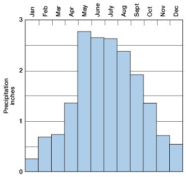
Figure 3--Graphs showing (A) the annual precipitation at Liberal, Kansas, and (B) the cumulative departure from the average precipitation at Liberal. (From records of the U.S. Weather Bureau.)
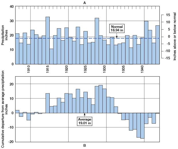
Figure 4--Graphs showing (A) the annual precipitation near Kismet, Kansas, and (B) the cumulative departure from the average precipitation near Kismet. (From records of the U.S. Weather Bureau.)
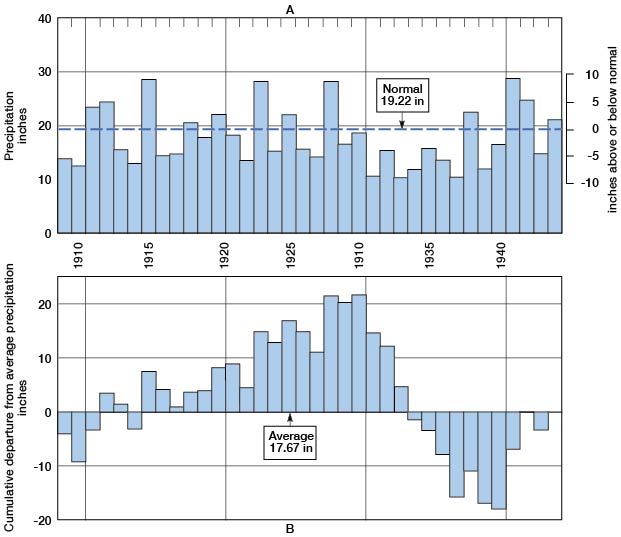
About three-fourths of the annual rainfall generally falls during the growing season. Most of the precipitation falls in rather violent storms, sometimes of cloudburst proportions, separated by long dry intervals, but occasionally it falls slowly. The extremes of precipitation at Liberal are: least rainfall in a year, 10.25 inches in 1916; most rainfall in a year, 32.42 inches in 1915. The recorded extremes at the station near Kismet are: least rainfall in a year, 9.95 inches in 1937; most rainfall in a year, 28.67 inches in 1941.
Agriculture
The county was first settled by ranchers in about 1883, being formally organized in 1886 and named for W. H. Seward, the Secretary of State under President Lincoln. For many years, cattle raising remained the major industry in the county. Most of the ranches were located along Cimarron River, as they are at the present time. The upland was cultivated then only for winter feed. In recent years there has been a slow trend back toward the cattle industry (Table 2).
Table 2--Average number of livestock in Seward County, by five years periods, 1910-1944. Compiled by the Department of Agricultural Economics, Kansas State Agricultural Experiment Station, Manhattan, Kansas.
| 1910-14 | 1915-19 | 1920-24 | 1925-29 | 1930-34 | 1935-39 | 1940-44 | |
|---|---|---|---|---|---|---|---|
| Milk cows | 2,767 | 2,751 | 1,791 | 1,564 | 1,487 | 1,713 | 1,776 |
| Other cattle | 5,722 | 9,785 | 8,874 | 6,853 | 8,085 | 6,055 | 13,784 |
| Hogs | 1,613 | 2,654 | 3,271 | 2,107 | 2,257 | 772 | 3,886 |
| Sheep | 593 | 359 | 72 | 12 | 117 | 872 | 8,622 |
| Hens | 34,447 | 26,680 | 28,748 | 47,340 | |||
| Horses | 2,786 | 3,721 | 4,297 | 3,241 | 2,007 | 1,095 | 724 |
| Mules | 879 | 1,284 | 1,735 | 1,265 | 418 | 133 | 52 |
In the area northeast of the river, the grass and row-crop agriculture gave way to the raising of wheat in about 1922 to 1924. Several years later the same change affected the section around Liberal and wheat continues to be the most important agricultural product of the county (Table 3). In the five-year period, 1930-1934, the acreage of wheat harvested averaged 94,379 a year, but during the same period an average of 39,682 acres of wheat was abandoned each year. During the same period the county produced each year an average of about 21,000 acres of corn, nearly 2,000 acres of barley, 25,000 to 45,000 acres of grain sorghums, and about 3,400 acres of broomcorn. At one time Liberal was reputed to be the largest grain-sorghum center in the world. The average individual crop yields, from 1922 to 1932, were: wheat, 10.6 bushels to the acre; corn, 13.2 bushels; barley, 13.4 bushels; kafir, 15.9 bushels; and milo, 17.1 bushels. The fluctuations in yield for all crops, in the same period, were 31 percent greater than the average for the State.
Table 3--Average acreage of crops harvested in Seward county, by five-year periods, 1910-1944. Compiled by the Department of Agricultural Economics, Kansas State Agricultural Experiment Station, Manhattan, Kansas.
| 1910-14 | 1915-19 | 1920-24 | 1925-29 | 1930-34 | 1935-39 | 1940-44 | |
|---|---|---|---|---|---|---|---|
| Wheat harvested |
26,789 | 42,167 | 59,308 | 100,325 | 94,379 | 63,535 | 132,120 |
| Wheat abondoned |
15,385 | 23,505 | 22,114 | 26,830 | 39,682 | ||
| Corn | 7,021 | 8,962 | 14,350 | 18,843 | 20,677 | 4,682 | 1,710 |
| Oats | 2,050 | 2,906 | 1,126 | 204 | 241 | 196 | 490 |
| Barley | 1,652 | 6,699 | 7,171 | 2,145 | 1,619 | 489 | 6,110 |
| Grain sorghums | 24,471 | 46,318 | 41,457 | 34,187 | 30,551 | 25,966 | |
| Alfalfa | 327 | 75 | 20 | ||||
| Broomcorn | 5,583 | 2,736 | 3,109 | 3,464 | 2,327 | 914 |
Drought and wind erosion have had a considerable influence on the agricultural practices within the county. Many farmers lost their farms as a result of the drought and left the county or remained as tenants, generally operating the farms under a cash-crop lease from an absentee owner (Table 4). The average size of the farm has been increased in the last several years by the practice of one person farming several properties previously operated by several individuals.
Table 4--Tenure of farms in Seward county in 1930, 1935, and 1940, in percentage of total acreage farmed. Compiled by the Department of Agricultural Economics, Kansas State Agricultural Experiment Station, Manhattan, Kansas.
| Owner | Part owner | Manager | Tenant | |
|---|---|---|---|---|
| 1930 | 17.8 | 36.8 | 0.2 | 45.2 |
| 1935 | 22.5 | 28.8 | 0.2 | 48.6 |
| 1940 | 20.7 | 24.5 | 0.2 | 54.6 |
The type of soil determines the crops that are raised. Loam and silt soils are seeded primarily to wheat, grain being a secondary cash crop. Fine sandy barns are devoted, about half and half, to the cultivation of wheat and row crops. Sandy barns are utilized for the same crops as the fine sandy barns, but are subject to blowing and probably should be reserved for cover crops and pasture (Gene Harris, County Farm Agent in 1940). The dune phase of the sandy loam soils generally is in pasture, but row crops and wheat are grown on some of it. These areas were once covered by bluestem but are now covered largely by sagebrush and other desert plants. The clayey lake bottoms, known also as buffalo wallows (p. 14) can be farmed, but are subject to drowning-out because of poor subsurface drainage. The alluvial sandy soils in Cimarron River Valley formerly were covered by excellent hay meadows, but the widening channel of the Cimarron has destroyed most of them.
Prev Page--Introduction || Next Page--Geography, continued
Kansas Geological Survey, Geohydrology
Web version Sept. 2001. Original publication date March 1948.
Comments to webadmin@kgs.ku.edu
The URL for this page is http://www.kgs.ku.edu/General/Geology/Seward/03_geog.html