![]()
Prev Page—Water Table || Next Page—Recovery
Ground Water, continued
Recharge
Recharge is the addition of water to the zone of saturation. Recharge in Scott County is derived from precipitation within the county, from influent streams, from infiltration as a result of the spreading of water for irrigation, and from subsurface inflow from areas to the west of the county. In the Scott Basin recharge to the underground reservoirs is accomplished by infiltration of floodwaters discharged on to the basin at the terminus of Whitewoman Creek.
Recharge from Local Precipitation
Most of the ground-water recharge in Scott County is derived from precipitation. The normal annual precipitation in Scott County as determined by the U.S. Weather Bureau in 1944 is 18.61 inches, and only a small part of this amount reaches the zone of saturation. Part of the water that falls on the surface of the county runs off through surface channels and is drained from the area by tributaries of Smoky Hill River, part is evaporated, part is transpired by plants, and part seeps downward through the soil zone and other rock material and recharges the ground-water reservoir. The amount and frequency of this replenishment depend in part upon the permeability of the intake materials. There is generally a lag between the time of precipitation and the time the water levels in wells begin to rise, and in areas where the water table is deep, recharge from infiltration from, the surface occurs only infrequently or at a rate so low that the effect upon water levels in wells cannot be observed except over long periods. The amount of precipitation necessary to produce recharge depends upon the season of the year and the character of the materials in the soil zone and in the zones of aeration and saturation.
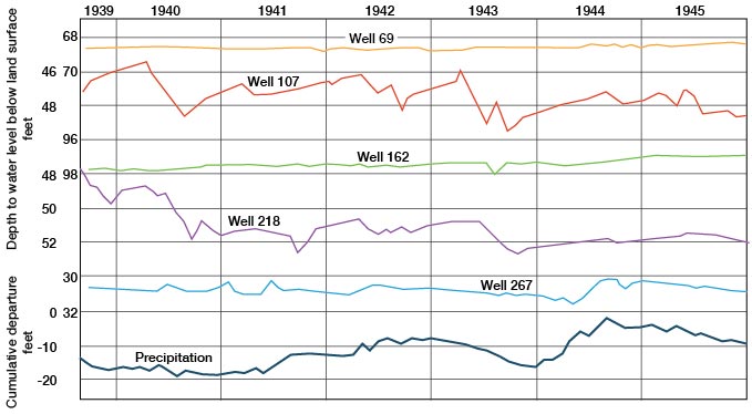
Fluctuations in ground-water levels in Scott County are related in some measure to the amount of recharge derived from the downward seepage of surface water, either directly from rain or melted snow or from streams and lakes supplied by rain and snow. The relation between the fluctuations of water levels and the depth to the water level in wells is shown best by the hydrographs of wells 69, 162, and 267 in Figure 9. Wells 69 and 162 are upland wells situated in the eastern part of Scott County. The depth to water level in well 69 is about 69 feet and in well 162 about 98 feet. Well 267 is a shallower well situated about 5 miles south of Shallow Water. The depth to water in this well is about 32 feet and the hydrograph shows that the water level in the well rises in response to heavy precipitation. According to the hydrographs of wells 69 and 162 shown in Figure 9, the water levels in these wells seem, to be only slightly affected by precipitation. The water levels in wells 107 and 218 whose hydrographs are shown in Figure 9 are affected by nearby pumping. For this reason the effects of precipitation upon the water levels in these wells have been obscured by the more dominant influence of the pumping.
Figure 9—Fluctuations of the water levels in five wells in Scott County and cumulative departure from normal precipitation at Scott City.
The fluctuations of the water level in four observation wells equipped with automatic water-stage recorders in the Scott County shallow water basin, the cumulative departure from normal precipitation at Scott City, and the acreage irrigated from wells in the shallow water basin are shown in Figure 10.
Figure 10—Graphs showing the water levels in four wells equipped with recorders, the cumulative departure from normal precipitation at Scott City since January 1, 1931, and the acreage irrigated from wells in the Scott Basin. (Water levels from automatic water-stage recorder charts and figures for irrigated acreage supplied by the Division of Water Resources, Kansas State Board of Agriculture. Cumulative departure compiled from records of the U.S. Weathers Bureau.)
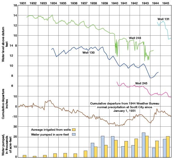
The water level in well 248 had a net decline during the period from October 23, 1931, through December 31, 1943, of 6.81 feet, which represents an average annual decline of 0.57 foot. The fluctuations of the water level in this well seem to correlate with the cumulative departure from normal precipitation, suggesting that the subnormal precipitation might be entirely responsible for the lowering of the water level in the well and in other wells in the area. It is shown in Figure 10, however, that the irrigated acreage in the shallow-water area has increased from 1,021 acres in 1932 to 21,320 acres in 1943 (Table 8). A somewhat similar correlation seems to exist between the fluctuations of water level in wells 130 and 245 and the cumulative departure from normal precipitation. A part of the decline in water level in each of these wells has been caused by a mounting deficiency in precipitation and a part has resulted from the effects of pumping as evidenced by the increase in irrigated acreage.
Table 8—Annual precipitation at Scott City, annual departure from normal, acreage irrigated from wells in the Scott Basin, and the annual net rise or net decline in water levels in wells 130, 245, and 248.
| Year | Annual precipitation at Scott City, inches (1) |
Annual departure from normal precipitation, inches |
Acreage irrigated from wells in the Scott Basin (2) |
Annual net rise (+) or net decline (-) in water level, feet |
||
|---|---|---|---|---|---|---|
| Well 248 | Well 130 | Well 245 | ||||
| 1931 | 18.38 | -0.23 | 2,265 | |||
| 1932 | 20.06 | 1.45 | 1,021 | 0.01 | ||
| 1933 | 24.84 | 6.23 | 2,035 | -0.43 | ||
| 1934 | 12.65 | -5.96 | 3,859 | -0.83 | ||
| 1935 | 15.54 | -3.07 | 4,234 | -0.06 | 0.62 | |
| 1936 | 18.24 | -0.37 | 3,849 | -0.31 | 0.71 | |
| 1937 | 13.11 | -5.50 | 6,828 | -0.59 | -0.22 | |
| 1938 | 14.92 | -5.80 | 10,355 | -0.40 | -0.03 | |
| 1939 | 14.63 | -3.98 | 12,298 | -0.79 | -2.07 | |
| 1940 | 16.88 | -1.73 | 17,164 | -1.15 | -1.37 | |
| 1941 | 24.63 | 6.02 | 16,427 | -0.20 | 0.05 | -0.33 |
| 1942 | 22.24 | -3.63 | 18,651 | -0.52 | 0.09 | -0.12 |
| 1943 | 10.38 | -8.23 | 21,320 | -1.71 | -2.49 | -1.60 |
| 1944 | 29.92 | 11.31 | 16,890 | 0.18 | 0.84 | 0.10 |
| 1945 | 14.22 | -4.39 | 21,002 | -0.73 | -1.55 | -0.43 |
| Normal | 18.61 | Average | -0.54 | -0.39 | ||
1. Compiled from records of the U.S. Weather Bureau
2. Acreage figures released by the Division of Water Resources of the
Kansas State Board of Agriculture
Throughout the growing season the moisture supply in the soil zone is depleted by the steady draft made by the plants and is replenished from time to time by rains or by irrigation. When rain occurs, this deficiency in the soil moisture supply must be satisfied before water will pass through the belt of soil moisture and move downward by gravity, either directly to the permanent zone of saturation or into the intermediate belt of the zone of aeration. The water table generally declines somewhat during the summer months owing to the withdrawal of water by plant transpiration and evaporation and by pumping for irrigation even though the precipitation may be greater than in the winter. During the winter months in places where the soil freezes to depths of a few feet, the frozen soil may be quite impermeable and may function as a formidable barrier to infiltration from the surface. In the spring when thawing commences, the soil becomes saturated with the water from the rains and melted snow. Some of the water released in this manner sinks rapidly and eventually joins the zone of saturation. In the areas of deep water table in Scott County, this thawing process may provide the principal additional ground-water storage for the year. There is relatively little evaporation and transpiration during the winter months, and at that time optimum conditions for recharge prevail.
Theis (1937) presented evidence to show that the average annual ground-water recharge from rainfall in the southern High Plains is somewhat less than half an inch. The intake materials near the surface in the upland areas lying outside the Scott Basin in Scott County are comparable to those of the southern High Plains, although the total annual precipitation is somewhat greater. Recharge as a result of rainfall penetration in Scott County probably averages slightly less than half an inch a year for several reasons: (1) most of the rainfall occurs during the growing season when the amount of water lost by transpiration and evaporation is the greatest; (2) the downward movement of water is impeded in most of the county lying outside of the Scott Basin by cemented beds of caliche in the Ogallala formation; and (3) some of the storm water remains in depressions for long periods after heavy rains, showing that very little infiltration takes place at these points. No figures regarding the annual amount of evaporation in Scott County are available, but the average rates of evaporation from a free water surface for the months of the growing season based on the 30-year record from 1908 to 1938 at the Garden City experimental farm are (Smith, 1940, p. 28): April, 6.68 inches; May, 8.46 inches; June, 10.25 inches; July, 11.90 inches; August, 10.42 inches; September, 8.10 inches. It is noteworthy that maximum evaporation occurs during the month of maximum rainfall and that the rate of evaporation greatly exceeds the rate of precipitation. It seems likely, therefore, that a rather large proportion of the annual precipitation in Scott County is lost through evaporation.
A part of the precipitation that falls is lost through runoff in streams, the amount being determined largely by the intensity of the rainfall, the slope of the land, the porosity of the soil, and the type and amount of vegetative cover. Conditions generally are much more favorable for rainfall penetration during a gentle rain of long duration than during a torrential downpour when the rate of runoff is high.
The slope of the land is an important factor in determining the amount of runoff, and, in general, the steeper the slope the greater the runoff. The slope of the land surface in nearly all of Scott County is relatively gentle, but steep slopes occur along Beaver Creek and smaller streams tributary to Smoky Hill River.
The type of soil also determines in part the proportion of the precipitation that will be lost as runoff and the part that will percolate into the underground reservoir. In general, runoff is greater in places where the soils are tightly compacted and fine-grained than in places where the soils are sandy and loosely compacted.
The velocity of the runoff is decreased by a suitable vegetative cover and under such conditions there is a better opportunity for part of the water to seep into the ground.
The loss of precipitation by runoff in Scott County is very small. Some runoff occurs along Beaver Creek in the northern part of the county as well as along several smaller tributary streams to Smoky Hill River. In the remainder of the county there is practically no surface runoff.
The most favorable areas in Scott County for ground-water recharge are the large depressional area south of Scott City known as the Scott Basin, locally along certain stretches of Whitewoman Creek and its tributaries, and the areas in the southeastern quarter of the county mantled by dune sand. There may be some groundwater recharge from storm water in shallow surface depressions on the uplands in Scott County.
Recharge in the Scott Basin
Scott Basin offers unusually good opportunities for recharge from precipitation and from infiltration of storm water during periods when the floor of the basin is covered by flood runoff from Whitewoman Creek. The temporary lake that forms at the terminus of Whitewoman Creek following heavy precipitation on its watershed to the west shrinks in volume in a relatively short time and a part of this water sinks into the ground. After passing through the soil zone, much of this water moves on down through more permeable intake materials to join the water table. There is little or no resistance to the downward movement of this water because of the relative absence of impermeable materials beneath the floor of the basin.
The configuration of the water table in the vicinity of the Scott Basin, as shown by the water-table contours in Plate 1, suggests that recharge is occurring in that part of the county. The contours along the eastern and southeastern side of the basin have been shifted progressively downgradient as a result of the heavy recharge in the area approximately enclosed by the 2,915-foot dashed contour. The amount and frequency of this recharge depend in large part upon the volume of water that is discharged into the basin, the approximate area that is inundated, and the length of time that the area is flooded. There is no opportunity for any of the storm water to leave the basin as runoff because of its low topographic position. It is probable that maximum recharge occurs during periods when the basin is inundated after the growing season at a time when transpiration and evaporation losses are low. The majority of the freshets that fall on the watershed of Whitewoman Creek occur during the growing season, however.
Recharge from Whitewoman Creek and its Tributaries
There is a possibility that some recharge occurs locally along certain stretches of Whitewoman Creek, particularly that part of its course, which traverses the Scott Basin, during periods of streamflow. It is also possible that some recharge occurs along some of the larger tributaries of Whitewoman Creek, including Lion Creek and Rocky Draw. The magnitude of the contribution to the zone of saturation during periods of excessive runoff is not known, but in general it is believed to be rather small. The periods when these watercourses carry storm runoff are infrequent and of short duration and very little opportunity is afforded for very much water to sink into the shallow stream bed and move downward to be added to the zone of saturation. The bulk of the storm water moves rapidly downstream and is debouched on the floor of the Scott Basin at the lower end of Whitewoman Creek.
Recharge in Depressions
Shallow depressions, or sinks, dot the uplands and parts of the Scott Basin in Scott County. The widespread occurrence of these depressional areas is strikingly portrayed on the aerial photographs of the county that were obtained from the Agricultural Adjustment Administration. The outlines of nearly all of them have also been shown on the topographic maps of the four 15-minute quadrangles that cover the county. The greatest concentration of these sink-like depressions occurs in the northeast quarter of the county. They are conspicuously absent in an area southwest of Scott City bounded on the north by State Highway 96 and on the south by Whitewoman Creek and extending westward to the county line. Sinks are quite common in the upland area northwest of Beaver Creek near the northwestern corner of the county. In the area that lies south and southeast of Beaver Creek, the sinks are less numerous than in the northeast quarter of the county. Their distribution is somewhat scattered in the southern part of the county--south, east, and southeast of Whitewoman Creek, and east and southeast of Shallow Water. After heavy rains, storm water collects in these small basins, forming temporary lakes. The water in some of these ponds disappears rather quickly, while in others it may remain for periods ranging from a week to several months. One of these storm-water lakes is shown in Plate 7B.
Plate 7B—Typical view of sink filled with water. Photograph after rains in October 1940. Near SW cor sec. 26, T. 18 S., R. 32 W.

The ability of such depressional areas to hold or lose water is entirely dependent on the character of the underlying materials. If the deposits beneath the floor of the sink are fine-textured and relatively impermeable, water will stand in the sink until it is evaporated. On the other hand, if the materials beneath the floor of the sink are relatively permeable, the accumulated water will sink rapidly downward until all of it is thus dissipated. Some studies .of the character of the deposits underlying similar depressions in the High Plains of Texas have been made by White, Broadhurst, and Lang (1940, p. 7). Several hundred test holes were drilled in the beds of depression ponds on the High Plains. These holes were drilled to an average depth of about 30 feet and spaced 100 to 300 feet apart in lines across the depressions. The studies showed that subsurface conditions beneath the depressions were extremely variable. In some of the depressions relatively little caliche was encountered, in others caliche was found all the way across but was relatively soft, and in still others the cemented beds were, dense enough to be designated rock by the drillers. In areas where the caliche was absent the sediments penetrated in many of the holes were relatively permeable from the surface to the bottom of the hole. This investigation also disclosed that (White, Broadhurst, and Lang, 1940, p. 7):
"The bottom of most of the depressions is covered with deposits of silt arid soil, in places resembling gumbo and ranging from two to ten feet in thickness. After the ponds become dry, fractures and crevices several feet in depth frequently develop in their beds. In some of the depressions small sinks, apparently developed by solution channeling in the underlying caliche deposits, are present. These crevices and solution channels may provide a pathway for the downward movement of water for a time after the ponds are filled, although they may become sealed after water has stood over them for several days. ... In some of the ponds the rate of decline was small and apparently was due mostly to losses from evaporation. In others, it was quite rapid, amounting in some cases to two inches or more a day for 10 days or so after the rains and then gradually slowing down."
Latta (1944, pp. 73-74) presented evidence to show that the fluctuations of the water level in a well in Finney County, which is situated in a depression similar to those under discussion, reflected the effects of recharge resulting from water percolating to the water table from storm water accumulated in the depression. This response was obvious in spite of the fact that the water level in the well was about 112 feet below the surface. He pointed out that as a result of recharge from this depressional area, a small mound on the water table was formed temporarily and that the mound was gradually reduced as the water moved out laterally. He also concluded that other depressions on the uplands probably act as catchment areas for recharge in the same manner.
It is believed that similar conditions exist in Scott County. Some of the floors of the depressions appear to be sealed rather tightly by an effective soil cover, while the floors of others seem to be traversed by cracks.
Summary
Much of the annual recharge to the ground-water reservoir in Scott County is derived from precipitation that falls on the county, from precipitation on the surface of the High Plains west of Scott County, and from infiltration of flood waters at the terminus of Whitewoman Creek. The amount and frequency of recharge from precipitation depend upon many variable factors. A part of the local precipitation enters the ground through areas of sand dunes and sandy soil, some of the storm water that collects in the numerous depressions scattered over the county sinks into the ground to join the water table, and small amounts of water move downward through channels of normally dry streams during periods of flood flow. Theis (1937) presented evidence to show that the average annual ground-water recharge from precipitation in the southern High Plains is somewhat less than half an inch.
Discharge
Ground water is discharged in Scott County by transpiration and evaporation, by seepage into streams, springs, and underground percolation that leaves the county, and by wells. The rate at which it is discharged is controlled by many factors, but especially by the stage of the water table and by the season of the year. Transpiration and evaporation of water from the zone of saturation are confined exclusively to areas where the water table is very shallow, such as in the lowest part of the Scott Basin. More ground water is pumped from irrigation wells in the Scott Basin than in the upland parts of the county. Seepage of ground water into streams occurs only along Beaver Creek and other smaller tributaries of Smoky Hill River in the northern part of the county. There is little or no natural discharge of ground water where the water table lies at great depth except for the water that is moving slowly out of the county to the east as indicated by the water-table contours on Plate 1. The amount of water that moves out of the county is approximately the amount that enters from the west plus whatever additions to or subtractions from the ground-water reservoir have been made within the county.
Transpiration and Evaporation
Water may be drawn into the roots of plants directly from the zone of saturation or from the capillary fringe, and discharged from the plants into the atmosphere by the process of transpiration (Meinzer, 1923a, p. 48). The rate at which water is withdrawn by this process varies with the type of plants, the depth to the water table, the climate and season of year, the character of the soil, and possibly other factors. The limit of lift by ordinary grasses and field crops is not more than a few feet, but some types of desert plants are known to have roots which penetrate to the water table 60 feet or more below the surface (Meinzer, 1923, p. 82). In most of Scott County, with the possible exception of the lowest part of the Scott Basin, the water table is considerably below the root tips of most plants, and water is withdrawn from the belt of soil moisture, thereby depleting the supply of soil moisture. In the lowest part of the Scott Basin south and east of Scott City and in some of the stream valleys many of the plants draw water directly from the zone of saturation. Evaporation of water directly from the zone of saturation is confined almost exclusively to land adjoining streams, where the water table is very shallow. In most parts of Scott County where the water table lies at considerable depth, no water from the zone of saturation is lost by direct evaporation; in such places only the soil moisture is evaporated.
The amount of water discharged annually by plant transpiration in Scott County is not definitely known, but it is probably very small in those areas where the water table lies more than 20 feet below the surface. In the lowest parts of the Scott Basin and in some of the stream valleys where the water table is shallow, the amount of ground water discharged by plants is somewhat greater. It is believed that the total quantity of water withdrawn by plant transpiration in the lowest part of the Scott Basin and in stream valleys is relatively small and much less than in the central Platte Valley in Nebraska.
Seepage into Streams
A stream that stands lower than the water table may receive water from the zone of saturation, and is known as an effluent stream. The principal streams that receive ground-water discharge in Scott County are Beaver Creek and several of the small northward-flowing tributaries of Chalk and Hell creeks in the northern part of the county.
As pointed out under the discussion of shape and slope of the water table, ground water moves in toward the lower part of Beaver Creek valley from both sides as shown by the water-table contours on Plate 1. Beaver Creek is a gaining stream, starting at a point about 5 miles northwest of Scott City and continuing throughout the remainder of its course northward; that is, it is effluent with respect to the water table. Where tributary streams have cut their channels below the water table, their flows are also augmented by ground water during most of the year.
Discharge from Springs
In Scott County some water is discharged through springs. All springs observed are in the northern part of the county along the lower stretches of Beaver Creek and its larger tributaries, and along several of the northward-flowing tributaries to Chalk and Hell creeks which are just north of the Logan-Scott County line. All the springs are along the valley sides of streams and are at or near the contact between the water-bearing sands and gravels of the Ogallala formation and the underlying chalk and chalky shale of the Smoky Hill chalk member of the Niobrara formation. The total quantity of water discharged by springs in Scott County is not definitely known, but it is thought to be small as compared to discharge by other means. It is probable that there is a large amount of seepage along the escarpments bordering the stream valleys that is not discernible, the water probably being dissipated by evaporation and transpiration as fast as it issues near the contact of the Ogallala and Niobrara formations. The known springs are described below under recovery.
Discharge from Wells
Discharge of ground water from wells in Scott County constitutes the principal discharge from the ground-water reservoir. Large amounts of water are pumped from irrigation wells in Scott County in addition to that pumped from industrial, public supply, and domestic wells. Most of the rural residents of the county derive their domestic and livestock supplies from wells, but the total amount of water pumped from these wells is comparatively small.
Prev Page—Water Table || Next Page—Recovery
Kansas Geological Survey, Geology
Comments to webadmin@kgs.ku.edu
Web version March 2003. Original publication date July 1947.
URL=http://www.kgs.ku.edu/General/Geology/Scott/05_gw3.html