![]()
Prev Page—Chemical Character || Next Page—Water Levels
Geologic Formations and Their Water-bearing Properties
Permian System
Rocks of Permian age are not exposed in Scott County, but they are found beneath younger rocks in all parts of the county. They are encountered at depths ranging from about 1,100 feet in the southern part to about 1,400 feet in the northern part. Data concerning these rocks are obtained from the logs of 23 oil and gas tests that have been drilled in Scott County.
The upper part of the Permian System (Guadalupian-Leonardian Series) is chiefly of nonmarine origin and is composed of red siltstone, shale, and sandstone with lesser amounts of salt, gypsum, anhydrite, limestone, and dolomite. This upper part, which is characterized by a predominance of red beds, ranges in thickness from about 1,200 feet in the northern part of Scott County to about 1,600 feet in the southern part. The lower part, or Wolfcampian Series, of the Permian System is largely of marine origin and is composed chiefly of limestone, dolomite, and shale, but also contains some sandstone. The thickness of the Wolfcampian Series ranges from about 600 feet in the southern part of the county to about 700 feet in the northern part.
The Permian strata underlying Scott County includes representatives of all the formations recognized by the State Geological Survey of Kansas from the Towle shale to the Taloga formation.
Because of their great depth and because adequate supplies of water can be obtained from the overlying rocks, the Permian rocks have not been utilized as a source of water in Scott County. Furthermore, it is believed that the water from Permian rocks would be too highly mineralized for most uses.
Cretaceous System
Rocks belonging to the Niobrara formation of Cretaceous age are exposed at the surface in Scott County. The outcrops of these rocks are shown on Plate 1. Cretaceous rocks older than the Niobrara formation are not exposed in this area and, therefore, are known only from subsurface data. They include representatives of the Carlile shale, Greenhorn limestone, Graneros shale, and the Dakota-Kiowa-Cheyenne sequence. The Niobrara formation furnishes water to wells in parts of the county, but because of their greater depth and because adequate supplies of water can generally be found above them, the rocks lying below the Niobrara formation have not been utilized as a source of water.
Pre-Niobrara Formations
The following discussion of the pre-Niobrara Cretaceous rocks of Scott County is based on the logs of oil wells drilled in the Shallow Water pool and on published reports (Elias, 1931, pp. 26-43; Landes and Keroher, 1939, pp. 10-16, 22-24; Latta, 1944, pp. 141-160; McLaughlin, 1943, pp. 116-136) that describe the geology of adjacent or nearby areas.
The oldest Cretaceous rocks present in Scott County belong to the Cheyenne-Dakota sequence or what was formerly called the Dakota group. They unconformably overlie the Permian rocks and consist of light- to dark-colored shale and sandy shale, variegated clay, and light-colored, fine- to coarse-grained sandstone. They are between 400 and 500 feet thick in this area. No attempt has been made here to differentiate these deposits into smaller units. In central and south-central Kansas they have been subdivided into three formations, which are, in ascending order, the Cheyenne sandstone, Kiowa shale, and Dakota formation.
The Cheyenne-Dakota sequence is overlain by the Graneros shale, which consists of gray noncalcareous shale and thin beds or lenses of sandstone and sandy shale. In Hamilton County, where the Graneros shale is exposed, it contains a thin bed of bentonitic clay and thin-bedded fossiliferous limestone (McLaughlin, 1943, p. 126). The thickness of the Graneros shale in Scott County is not known. It is a few feet to about 43 feet thick in Ford County (Waite, 1942, p. 148), 61 feet thick in Hamilton County (McLaughlin, 1943, p. 128), and 90 feet thick in western Logan County (Landes and Keroher, 1939, p. 24).
Approximately 100 feet of interbedded light-gray to dark-gray chalky limestone and calcareous shale of the Greenhorn limestone occurs above the Graneros shale.
The Greenhorn limestone is overlain by the Carlile shale, the lower part of which consists of chalky shale containing thin beds of chalk and the upper part consists chiefly of dark noncalcareous fissile shale. The thickness of the Carlile in this area is approximately 200 feet. The Carlile shale is composed of three members, which are, from oldest to youngest, the Fairport chalky shale member, the Blue Hill shale member and the Codell sandstone member. An oil well drilled in the SE sec. 15, T. 20 S., R. 33 W., encountered about 10 feet of medium-gray soft sandy shale at the top of the Carlile shale that probably represents the Codell sandstone member in this area. It was not possible to recognize the other members of the Carlile in this area.
Niobrara Formation
Character—The Niobrara formation is divided into two members—The Fort Hays limestone member below and the Smoky Hill chalk member above.
The Fort Hays limestone member does not crop out in Scott County, but was encountered in test hole 23 near the southwest corner of the county. The Fort Hays is composed of thick massive beds of chalky limestone and chalk separated by thin beds of chalky shale. The limestone and chalk beds range in thickness from less than 1 foot to several feet and are light to dark gray where unweathered. Weathered exposures of the Fort Hays limestone member in areas adjacent to Scott County are white, tan, or cream. The contained fossils include Inoceramus deformis, Ostrea congesta, and abundant foraminifera (Moss, 1932, p. 21).
The Fort Hays limestone member is conformably overlain by the Smoky Hill chalk member of the Niobrara formation. The Smoky Hill chalk member crops out in the northern and southeastern parts of Scott County, in the western part of the county in a small area on the south side of Rocky Draw about 512 miles south of Modoc, and was encountered below younger rocks in all of the test holes. It consists of alternating beds of soft chalky shale and chalk. Where unweathered the beds are light to dark gray or gray brown, but on weathered exposures they are white, tan, buff, or yellowish pink. It is difficult to differentiate the individual beds in the subsurface. The slight differences in the composition of different beds are brought out on weathered exposures through differential erosion so that even the thinnest beds stand out. The member also contains thin beds of bentonite and pyrite concretions. The bentonite beds are light colored when unweathered, but weather to a rusty brown.
Both vertebrate and invertebrate fossils occur in the Smoky Hill chalk. The vertebrates include birds, dinosaurs, crocodiles, mosasaurs, turtles, and fish. Inoceramus grandis and Ostrea congesta are most abundant among the larger invertebrates (Moss, 1932, p. 19). Foraminifera, chiefly Globigerina and Gumbelina, are abundant in the chalky beds, and, according to Moss (1932, p. 19), probably make up more than half of the calcareous material of the chalk.
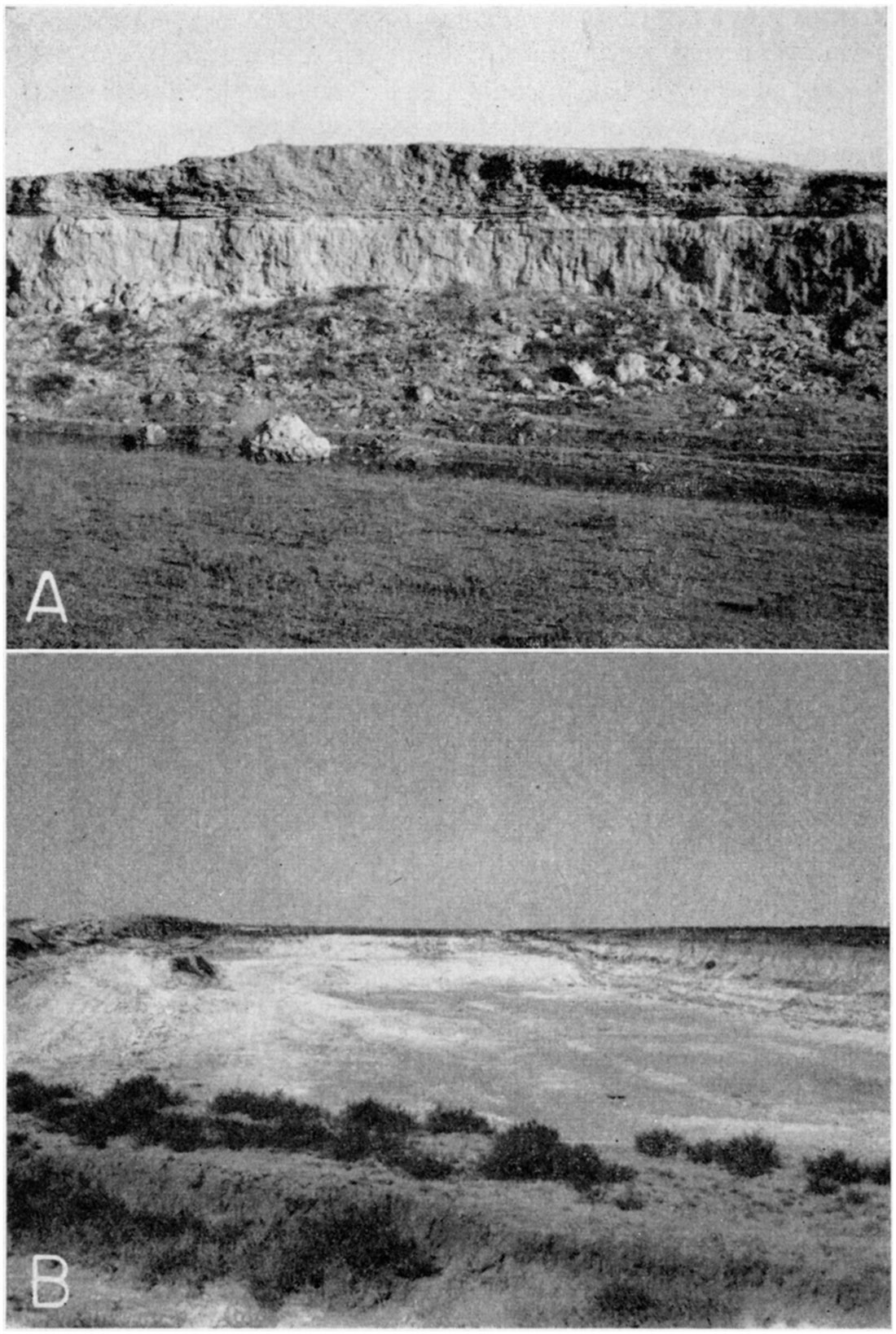
Some of the most striking features of the Smoky Hill chalk are the tilted fault blocks that occur in the northern part of the county where the chalk lies at the surface. With a few minor exceptions, the faults are all normal faults, and are commonly marked by a slickensided calcareous gouge (Pls. 4A and 14). Russell (1929, pp. 594-604) described the stratigraphy and structure of the Smoky Hill chalk member in western Kansas and concluded that the faulting probably occurred during the Tertiary and was presumably produced by the adjustment of the brittle chalk to deformation and not to compaction.
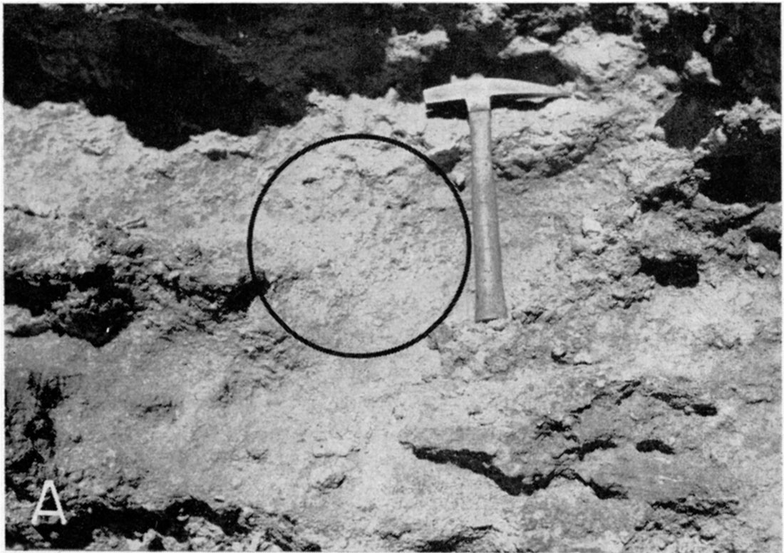
Plate 4A—Normal fault in Smoky Hill chalk member of the Niobrara formation in the NE NE sec. 1, T. 16 S., R. 32 W. Approximate displacement 20 feet.
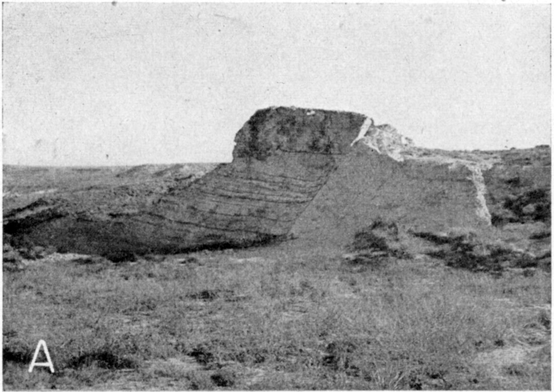
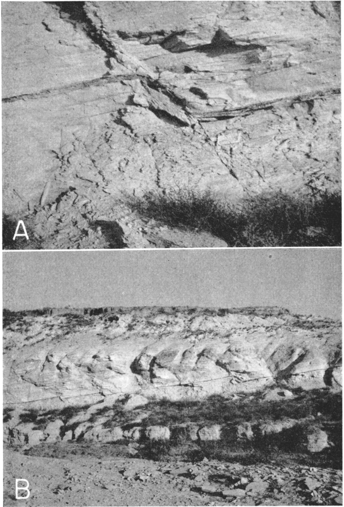
Plate 14—A, Small normal fault in the Smoky Hill chalk member of the Niobrara formation. Note crystalline calcite filling the fault fissure and curvature of the dark band near the fault plane as a result of drag. Displacement is 2 feet. SE NE sec. 1, T. 16 S., R. 32 W. B, Series of small step faults in the Smoky Hill chalk member. Same exposure as shown in above closeup view.
Distribution and thickness—Only the Smoky Hill chalk member of the Niobrara formation is exposed in Scott County. It is best exposed in the northern and northeastern parts of the county where streams tributary to Smoky Hill River have cut down through the plains surface into the underlying Smoky Hill chalk (Pls. 1 and 4B). Exposures of this member in the southeastern part of the county occur in short draws west and northwest of Dry Lake. Both members of the Niobrara formation are present beneath younger sediments everywhere in Scott County.
The thickness of the Niobrara formation in western Logan County, Kansas, where it is overlain conformably by the Pierre shale, is approximately 600 feet. Pre-Ogallala erosion, however, has truncated the Niobrara to the south and east so that the maximum remaining thickness of the formation in Scott County is much less. The thickness of the formation in north-central Finney County is only about 300 feet (Latta, 1944, p. 159). Only the lower part of the Smoky Hill chalk member is present in Scott County. The total thickness of the Fort Hays limestone member is present beneath the Smoky Hill chalk member in this area. In the southwestern corner of the county the Fort Hays member is 55 feet thick (log 23).
Water supply—The Niobrara is relatively unimportant as a water-bearing formation in Scott County. The Fort Hays limestone member does not supply water to any wells in this area. The beds of chalky shale and chalk that make up the Smoky Hill chalk member are relatively impervious and transmit water chiefly through fractures and solution channels. Several of the recorded wells (Nos. 154-156, 160, 162, and 166) in the southeastern part of Scott County tap the Smoky Hill chalk member. In this part of the county the overlying Pliocene and Pleistocene sands and gravels are above the water table and, therefore, are barren of water. Of the wells that are known to derive their entire supply from the Smoky Hill chalk member only well 166 was in use at the time the wells were visited in 1940.
An analysis of a sample of water collected from well 166 indicates that the water is similar to many from the overlying Pliocene and Pleistocene deposits. The water from this well had 264 parts per million of total solids, 240 parts of hardness, and 1.4 parts of iron.
Tertiary System—Pliocene Series
Ogallala formation
Character—The Ogallala formation is composed of silts, sands, and gravels and contains layers of sandstone and conglomerate, much of which is crossbedded and cemented with lime. In general, the fine-grained sediments alternate with the coarser lime-cemented beds at different horizons. The Ogallala sediments are generally buff colored to pinkish, although some of the more limy silts and sands are white to whitish gray. The coarser sediments are present at all horizons but are most prominent in the lower part of the formation, and it is this part that yields water most freely to wells. Locally, the lower part of the Ogallala formation may be composed of bentonitic clays of bright mottled colors ranging from reddish brown to olive green. These basal clays represent a local lateral change in lithology in the lower part of the Ogallala formation and may be equivalent to the Woodhouse clays of either Miocene or Lower Pliocene age of Wallace County, Kansas, described by Elias (1931, pp. 155-158).
Sand constitutes the principal material of the Ogallala formation and ranges in texture from fine- to coarse-grained, some of the coarser material containing scattered pebbles and thin beds of pebbles (Pl. 8A). The finer-textured materials of the Ogallala formation are composed chiefly of silt that generally is intermixed with fine sand. Lenses or beds of sandy silt occur in all parts of the formation, but principally in the upper part. The color of the silt ranges from gray to buff to light tan. Some of the beds of silt are impregnated with lime giving them a white to light-gray color. Gradations from one lithologic type to another may take place both laterally and vertically—sometimes within relatively short distances.
Plate 8A—View of north face of gravel pit in Scott County State Park showing cross-bedding of deposits of sand and gravel of Tertiary age.
The coarser-textured materials of the Ogallala formation are composed of fine to very coarse gravel and they may occur in almost any part of the formation from the base to the top. Smith (1940, pp. 42, 43) described two distinct facies of gravel in the Ogallala formation, one composed principally of sandstone, ironstone, and quartzite, and the other made up mainly of crystalline igneous and metamorphic rocks. The former facies occurs at the base of the formation and the latter is widespread along Beaver (Ladder) Creek in outcrops above the base of the formation. The sandstone-ironstone-quartzite facies is composed of material similar to that found in the Dakota formation and other Cretaceous formations, whereas the granite facies that occurs above the base of the formation is composed of granite, feldspar, quartzite, quartz, felsite and other crystalline igneous and metamorphic rocks.
The Ogallala formation is characterized by lenticular bedding; thus, individual beds of sand or gravel are not continuous over wide areas, but generally are discontinuous lenses that may grade laterally into finer materials such as silt or clay, in some places within relatively short distances. The deposits range from those that show definite bedding to those that show no bedding whatever. The structureless layers are commonly found in the upper part of the formation, are rather fine-grained, and contain some silt and small amounts of clay and lime. Irregular limy concretions are abundant in these layers, typical exposures of which occur in the bluffs on both sides of Beaver (Ladder) Creek in the vicinity of Scott County State Park. They are well displayed in both sides of the road cut that was constructed through the "Devil's Backbone," about 1 mile south of the south entrance to Scott County State Park (Pl. 5A). The color of this structureless part of the Ogallala ranges from buff tan to light reddish brown.
Plate 5A—Lime concretions in the Ogallala formation in a road cut through the Devil's Backbone at the south end of Scott County State Park.
In many places the deposits are consolidated by calcium carbonate, forming beds of caliche. In some places the cemented beds resemble true limestone; elsewhere they may consist of sand and pebbles imbedded in a lime matrix. Calcium carbonate is distributed through the deposits both as fine material and in the form of small and medium-sized nodules, pipy concretions, and in irregular lenses and beds. The caliche is white to gray and generally is fairly soft. It has been used locally in the construction of roads and highways in Scott County (Pl. 6B). In many places the sedimentary materials of the Ogallala formation are so firmly cemented with calcium carbonate as to produce a series of hard ledges, interbedded with only slightly cemented beds (Pls. 5B and 6A). The hard ledges are usually unevenly cemented and form rough weathered benches and cliffs. Because of their resemblance to old mortar, these beds have long been referred to as "mortar beds."
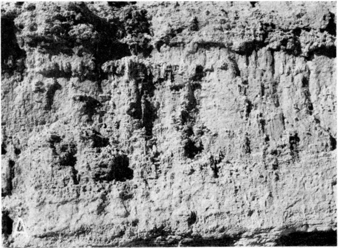
Plate 6—A, Series of many thin parallel "mortar beds" resting on structure-less cemented sandy silt of the Ogallala formation. East side of Salt Creek in the NE sec. 24, T. 16. S., R. 31 W. B, "Caliche" of the Ogallala formation exposed in County quarry in the SW sec. 28, T. 18 S., R. 32 W.
The thickness of some of the cemented caliche beds is very irregular and ranges from a few inches to about 11 feet. In some places the Ogallala formation is capped by a rather distinctive limestone layer, referred to as the capping limestone by Smith (1940, pp. 44-45). It. is commonly massive, and weathers to a knobby, cavernous, or irregular surface, and has a maximum thickness of about 5 feet. Elias (1931, pp. 136-141) described an equivalent horizon in Wallace County and adjacent areas and referred to it as "Algal limestone" because of its peculiar concentrically banded structure. In Scott County, outcrops similar to the capping limestone described by Smith and Elias were found in which algal structure was very prominent. The most notable of these was an outcrop in the southeastern part of the county in the SW SE sec. 5, T. 20 S., R. 31 W. A thin development of the same bed resting directly on the Niobrara formation was noted in an exposure in the SW SE sec. 12, T. 20 S., R. 32 W. Two other outcrops were noted in which the algal structure was less prominent, one situated about 1 mile south and 5 miles west of Scott City near the SW cor. sec. 20, T. 18 S., R. 33 W., the other situated about 5 1/2 miles south of Modoc, in the NW SE sec. 16, T. 19 S., R. 34 W. The former represents a very poor exposure and consists principally of fragments of limy rubble strewn along the side slopes of Lion Creek, but the individual fragments exhibited poor algal structure. The general lithology of the Ogallala formation at the surface is indicated by the following measured sections.
| Section of Ogallala formation on the east side of Lake McBride in Scott County State Park near the NE cor. NW sec. 12, T. 16 S., R. 33 W. | Thickness (feet) |
|
|---|---|---|
| Surface covered with unconsolidated sand and gravel | ||
| Tertiary—Pliocene | ||
| 11. Silt, sandy, lime-cemented, hard, gray to white; contains scattered coarse gravel and some pebbles; grades upward into a lime-cemented silt and becomes whiter in color near top; resembles a true "caliche" | 28 | |
| 10. Sand, silty, lime-cemented, dirty gray, extremely hard and resistant; contains pebbles up to 1 inch in diameter and larger imbedded firmly in the coarse sandy matrix; forms distinct caprock ledge | 2 | |
| 9. Silt, sandy, cemented, hard, gray to buff | 1 | |
| 8. Sand and silt, cemented, gritty, irregular ("mortar bed"); into lighter gray structureless sandy silt | 6 | |
| 7. Sand, silty, lime-cemented, dirty gray; grades upward into white limy silt | 5 | |
| 6. Sand, silty, cemented, buff colored; contains pebbles up to 1/2-inch in diameter and larger imbedded in sandy matrix; forms resistant ledge | 8 | |
| 5. Sand, silty, cemented, massive, hard, somewhat siliceous, dark gray to buff; contains a seam of extremely hard dense blue chert ranging from about 1 to 8 inches in thickness at top | 4 | |
| 4. Sand, silty, cemented, brown to buff; forms distinct smooth-faced bench in bordering bluffs | 7 | |
| 3. Sand, silty, cemented, hard, gray; contains scattered coarse gravel; also contains some rather thin-bedded layers in the lower part that tend to break off in thin slabs ranging in thickness from about 1 to 3 inches | 17 | |
| 2. Sand, cemented, gritty, gray; contains coarse gravel and scattered pebbles; grades upward near the top to a hard cemented silty sand, brownish-buff in color; forms a resistant ledge at the top that stands out in the bluffs bordering the lake | 47 | |
| 1. Clay, plastic, brown to chocolate brown, mottled in part with pale-green splotches (Woodhouse clays?) | 16 | |
| Total thickness of Ogallala exposed | 141 | |
| Cretaceous (Upper) | ||
| Niobrara formation | ||
| Section of Ogallala formation at the north end of Scott County State Park in the NW SE sec. 2, T. 16 S., R. 33 W. (Measured by H. T. U. Smith, H. A. Waite, and L. P. Buck.) | Thickness (feet) |
|
|---|---|---|
| Tertiary—Pliocene | ||
| 11. "Limestone," sandy, cemented ("mortar bed"); weathers chunky, somewhat porous, harder near the top | 11 | |
| 10. Sand, cemented, calichiferous (covered interval) | 9.5 | |
| 9. Sand, cemented, hard, resistant ("mortar bed"); weathers very knobby and irregular; cavernous throughout | 6 | |
| 8. Sand and silt, cemented, gritty, irregular ("mortar bed"); slabby in lower part, cavernous in upper part; contains some pebbles and limy concretions that look like reworked caliche nodules | 6 | |
| 7. Gravel, cemented, sandy, gritty, structureless | 4.5 | |
| 6. Sand and gravel (covered interval) | 35 | |
| 5. Silt, sand, and gravel, cemented, hard, gritty ("mortar bed"), weathers cavernous in lower part and slabby above; contains some short vertical concretions | 6 | |
| 4. Caliche, massive, gritty, structureless; contains small scattered pebbles and irregular limy concretions, some having root shape - weathers irregularly knobby; contains fossil grass seeds Biorbia fossilia (middle Pliocene) | 11 | |
| 3. Sand, covered interval | 29.5 | |
| 2. Sand and gravel, crossbedded, locally cemented; fossil bone found at a point 14 feet above bottom. (Sand and gravel have been excavated at this interval for use in the State Park.) View of gravel pit in Plate 8A | 20 | |
| 1. Clay, buff, massive; contains some gray layers and is somewhat silty in upper part (Woodhouse clays?) | 23 | |
| Total thickness of Ogallala exposed | 161.5 | |
| Cretaceous (Upper) | ||
| Niobrara formation | ||
Distribution and thickness—Exposures of the Ogallala formation occur along Beaver (Ladder) Creek and in tributary draws in the northwestern part of the county (Pl. 1). The Ogallala formation is also exposed in the northern part of the county along the sides of draws tributary to Chalk Creek, which flows eastward across the southern part of Logan County to the north. Exposures of the Ogallala formation occur above the Cretaceous rocks in the northeastern part of the county along draws tributary to Hell Creek which flows eastward near the southeastern boundary of Logan County and along the southern boundary of Gove County. Outcrops of the Ogallala formation occur along Lion Creek from near Modoc to a point about 4 miles west of Scott City and along Rocky Draw from the west county line to a point about 5 1/2 miles south of Modoc. Isolated exposures of the Ogallala formation have been noted near the heads of draws tributary to Dry Lake in the southeastern part of the county. Most of the upland surface in Scott County is underlain by deposits of Pleistocene age. The Ogallala formation, however, is found beneath younger deposits over most of the area. It is thin to practically absent in the Dry Lake vicinity near the southeastern corner of Scott County occupied by the buried Cretaceous hill shown in Figure 2.
The Ogallala formation was not encountered in test holes 13, 16, 17, and 19 (logs 13, 16, 17, and 19), all of which are situated in the deepest part of the buried trough (Fig. 5, sections B-B' and C-C'). It is probable that the Ogallala formation was removed by erosion and in its place 'sediments of Pleistocene age were deposited. Section B-B' shown in Figure 5 shows that the Ogallala formation is very thin in the vicinity of test holes 12, 14, 15, and 18 in the eastern part of the county east of Shallow Water. In certain areas in the southeastern part of the county deposits of dune sand overlie the Ogallala formation.
The Ogallala formation ranges in thickness from a few feet to about 160 feet. The variable thickness of the Ogallala formation is shown in the three profile sections in Figure 5. The thickness of the Ogallala in the 23 test holes drilled during the investigation ranges from about 6 feet in test hole 12 in the eastern part of the county to 159 feet in test hole 1 situated about 6 miles north of Scott City. In general, the test drilling revealed that the Ogallala becomes progressively thinner from north to south and in a southeasterly direction toward the southeastern corner of the county. The thickness of the Ogallala formation ranges within wide limits because of the uneven surface on which the sediments were deposited and also in part because of the fact that all or part of the sediments were removed during post-Ogallala erosion. At one time the Ogallala formation probably was much thicker in the vicinity of the buried trough in the vicinity of Scott City and Shallow Water but most of it was removed by post-Ogallala erosion.
Origin—As pointed out under Geologic History the sediments comprising the Ogallala formation were deposited by heavily laden streams that flowed from the Rocky Mountain region. The pebbles of igneous and metamorphic rocks in the gravels and abundance of quartz and feldspar in the sands are believed to have been derived from the Rocky Mountains. Locally, the basal gravels also contain some reworked material from less distant sources, including water-worn fragments derived from Cretaceous rocks in or just west of the county. Smith (1940, pp. 85-86) describes the mode of deposition of the Ogallala formation as follows:
"The deposition of the Ogallala was mainly of the channel and floodplain type. The coarser beds of sand, gravel, and grit represent channel deposits. ... The finer materials are best interpreted as representing flood-water deposits formed by the overflow of shallow channels, perhaps approaching the character of sheet-floods locally. No recognizable deposits of eolian sand or silt have been found in the Ogallala in the area studied, but the presence of ventifacts indicates that there must have been appreciable wind action.
"The deposition of the Ogallala formation began with the change from stream degradation to aggradation. ... During the early stages of deposition, there was a topography of moderate relief. The main valleys were occupied by through-going streams from the Rocky Mountains, and the valley bottoms were mantled by normal floodplain deposits. ... Deposition probably began with the filling of stream channels, leading to more frequent overflow and thus to the up-building of the floodplains. This soon led to shifting of the channels themselves, and probably to the development of anastomosing patterns. As filling progressed, the valley flat overlapped farther and farther on the slopes of the bordering hills. ... Relief was lowered, the valley plains grew broader, and finally the divides were overtopped, and there followed overlapping and coalescing of the depositional zones of individual streams."
The origin of the abundant calcium carbonate in the Ogallala has been discussed by Smith (1940, p. 79) who concluded that
"The transported calcareous matter in the Ogallala originated mainly, if not only, in the Rocky Mountain area from weathering of Paleozoic limestone and calcic minerals in the crystalline rocks. ... Additional lime may have been provided also by weathering in situ after deposition."
Smith also suggested that the silt and clay of the Ogallala formation probably were derived from soils and weathering products in the mountain area and, to a lesser extent, from the wearing down of coarser materials in transit. The sandstone and conglomerate in the Ogallala represent beds of sand and gravel that have been cemented by underground waters. Deposits of sandy silt, cemented with calcium carbonate and often referred to as caliche, probably are a product of surficial calichification formed during a relatively long pause in deposition, at a time when streams had shifted to some other part of the region. The concentration of calcium carbonate, in the soil zone, by surficial processes was accomplished during such periods, and was halted by recurring periods of deposition to give rise to caliche zones at varying intervals throughout the formation. Smith (1940, pp. 77-94) gave a much more detailed discussion of the origin of the Ogallala formation.
Age and correlation—The Ogallala formation originally was named and described by Darton (1899, pp. 732, 734) and its age was given as late Tertiary, or Pliocene (?). Darton later (1920, p. 6) designated the type locality near Ogallala station in western Nebraska. The conclusions of later workers regarding the age and correlation of the Ogallala formation in western Kansas have been summarized by Smith (1940, pp. 73-74).
Smith (1940, pp. 75-76) concluded that the Ogallala of southwestern Kansas, insofar as it is represented by exposures at the surface, may be assigned to middle Pliocene age. According to this definition, the top of the Ogallala formation is marked by the top of the capping limestone. No upper Pliocene beds were recognized in Scott County, and no attempt has been made to subdivide the Ogallala formation.
So far as is known, no vertebrate fossils have been taken from the Ogallala formation in Scott County. In Ford County, a horse tooth was recovered from the Ogallala at a depth of 113 feet during the drilling of an irrigation well in the SW sec. 6, T. 27 S., R. 26 W. The tooth was identified by C. W. Hibbard as a right molar of Pliohippus cf. interpolatus (Waite, 1942, p. 160). Schoff (1939, pp. 61-62) reported that large collections of vertebrate remains taken from excavations in the vicinity of Optima and Guymon, Texas County, Oklahoma, were considered by Stovall to be middle Pliocene in age. According to Schoff, the fossils were found in the upper 100 feet of the formation.
Fossil grass and hackberry seeds collected from the Ogallala formation have been described by Elias (1932, pp. 333-340). In a later paper (Chancy and Elias, 1936) it was shown that certain of the fossil seeds are of widespread occurrence and have a short vertical range making them useful as guide fossils. Fossil grass and hackberry seeds were collected by me from the Ogallala formation in Scott County, notably from exposures in the bluffs just west of the dam at the north end of Lake McBride near the center sec. 2, T. 16 S., R. 33 W. (Pl. 13A) and from exposures in the bluffs on the east side of Lake McBride below the McBride monument in the NW NE sec. 12, T. 16 S., R. 33 W. In both localities the seeds were collected from massive layers of cemented grit and coarse sand from 5 to 10 feet in thickness that formed prominent benches along the sides of the valley. Fossil grass and hackberry seeds were also collected from exposures of the Ogallala formation in the northeastern part of the county in the SE NE sec. 1, T. 16 S., R. 32 W. Fragments of grass and hackberry seeds were found in test hole 23 in the southwestern corner of Scott County between depths of 103.5 and 119 feet. From comparisons with forms described by Elias, the grass seeds are believed to be Biorbia fossilia and the hackberry seeds are believed to be Celtis willistoni.
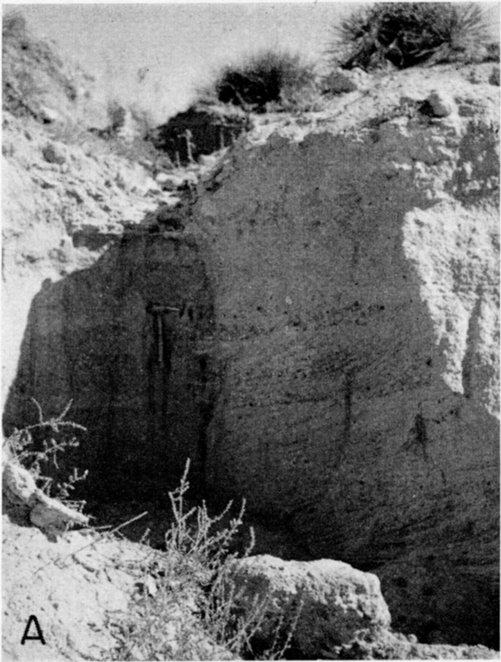
Plate 13A—Cluster of Biorbia fossilia seeds in Ogallala formation at north end of Scott County State Park in the NW SE sec. 2, T. 16 S., R. 33 W.
Water supply—In Scott County, as in many other parts of the High Plains, the Ogallala formation is the most important water-bearing formation. Most of the domestic and stock wells in the outlying upland areas surrounding the Scott Basin, as well as many of the irrigation wells and industrial and public supply wells, derive water from the Ogallala formation. Many of the wells in the Scott Basin derive water from the undifferentiated Pleistocene deposits overlying the Ogallala formation and some of the wells penetrate these deposits as well as the Ogallala formation below and may obtain water from both sources. The Ogallala formation also supplies water to springs in the northern part of the county, notably Big Springs, Barrel Springs, and Old Steele Home Springs, all situated in the Scott County State Park (Pl. 1, springs 16, 17, 18). The yields of wells tapping the Ogallala range from several gallons a minute from small domestic and stock wells to about 2,900 gallons a minute for some of the large irrigation wells (200). The largest yields from the Ogallala are obtained from the coarser materials generally in the lower part of the formation. The beds of the Ogallala formation once extended from the Rocky Mountains eastward to perhaps as far as the eastern third of Kansas, but they have been removed by erosion from much of the territory they once occupied. A much greater thickness of the formation may have been saturated at one time, but streams such as Beaver (Ladder) Creek in the northern part of the county and tributaries to streams in Logan and Gove counties to the north of Scott County have cut below the zone of saturation and are draining part of the water from the formation. In parts of southeastern Scott County the Ogallala and Pleistocene beds are comparatively thin and lie entirely above the water table (sec. B-B', Fig. 5). The thickness of saturated material, as shown by the profile sections in Figure 5, differs greatly. Logs of test holes indicate that a large percentage of the saturated zone in the Ogallala and the Pleistocene deposits is composed of sand and gravel, so the amount of water available is large.
In recent years there has been an increase in the number of wells tapping the Ogallala formation in Scott County, largely as a result of increased demands for irrigation and industrial supplies.
The water from the Ogallala formation is hard. The analyses of typical waters from the Ogallala formation are shown in Figure 16. Samples of water were collected from 19 wells that derived water from the Ogallala formation, from six wells that derived water from the Ogallala formation and/or undifferentiated Pleistocene deposits, and from three wells that derived water from the Ogallala and/or Niobrara formations. Analyses of the 19 samples of water collected from the Ogallala formation indicate that the hardness ranged from 162 to 319 parts per million and averaged about 221 parts. The analyses also indicate that the amount of iron contained in these samples of water from the Ogallala ranged from 0.0 to 2.9 parts per million. The fluoride content of these 19 samples ranged from 0.3 to 3.0 parts per million. Three samples of water from this group contained less than 1 part per million of fluoride, six contained more than 1 part, nine contained between 2 and 3 parts, and one contained 3 parts. Because the fluoride content of some of the water from the Ogallala formation is relatively high, some water derived from this source may be harmful to children's teeth. The analyses show also that the amount of sulfate contained in these 19 samples of water from the Ogallala ranged from 8.4 to 84 parts per million and averaged about 44 parts. The analyses indicate that the water from the Ogallala is well within the suggested safe use for irrigation. The water in the Ogallala is generally softer than the water in the overlying undifferentiated Pleistocene deposits.
Quaternary System—Pleistocene Series
Undifferentiated Deposits
Deposits of gravel, sand, silt, and clay overlie the Ogallala formation and although somewhat similar lithologically to the Ogallala formation, they are of Pleistocene age. It has not been practicable to subdivide these deposits into smaller units, so they are referred to as undifferentiated Pleistocene deposits.
Character—The undifferentiated Pleistocene deposits consist principally of unconsolidated gravel, sand, silt, and clay. Sand and gravel are the most abundant materials and silt and clay occur in lesser amounts but locally may be the predominant constituents. The coarse sand and the gravel are composed of quartz, feldspar, and other material derived from igneous rock. Water-worn pebbles of caliche derived from the Ogallala formation are common in these deposits, particularly in the lower part near the contact between these deposits and the underlying Ogallala formation. In places where the Ogallala formation is relatively thin or absent, water-worn pebbles of materials derived from rocks of Cretaceous age, principally from the Niobrara formation, are scattered through the deposits.
The Pleistocene deposits are poorly sorted and very lenticular. Individual beds are discontinuous and may grade laterally or vertically from one lithologic type to another within relatively short distances. Interbedded with the sands and gravels are many lenses of silt, sandy clay, and clay. Clay in the form of rounded "clay balls" that range in diameter from a few inches to more than a foot are interspersed throughout the deposits. These deposits are for the most part unconsolidated. Some beds, however, are cemented by calcium carbonate to form hard "mortar beds" resembling concrete, a notable example being the cemented deposits occurring along the south bank of Beaver (Ladder) Creek, just above the water surface, at a point just below the bridge in the NW SW sec. 21, T. 17 S., R. 33 W.
The undifferentiated Pleistocene deposits include the terrace deposits of Beaver (Ladder) Creek valley which are composed mainly of gravel containing intermixed sand, silt, and clay. The sand and gravel is composed principally of material derived from igneous rocks. The terrace deposits are patchy in character and occur as isolated terrace remnants of channel deposits that were formerly much more extensive. Downcutting by Beaver Creek was responsible for the removal of most of the channel deposits, leaving scattered isolated remnants along the valley sides. The terrace deposits are of commercial importance and are the source of sand and gravel used for construction materials locally. The Geist (Christy) gravel pit, situated in the NE SW sec. 21, T. 17 S., R. 33 W., has been in operation intermittently for several years and large amounts of gravel and sand have been removed for construction purposes. Although not used in 1940 as extensively as the Geist (Christy) pit, two other gravel pits have been operated on terrace deposits along Beaver (Ladder) Creek valley - the Garvin gravel pit, situated on the section line between secs. 22 and 23, T. 17 S., R. 34 W. about a quarter of a mile south of the north section line, and the Gilbert Lenz gravel pit, situated in the SE NW sec. 22, T. 17 S., R. 34 W. The sand and gravel deposits at the Garvin pit are about 15 feet thick according to a measurement of the south vertical face of the workings in 1940. Similarly, the deposits of sand and gravel at the Lenz pit were from 15 to 18 feet in thickness in 1940, the deposits consisting of crossbedded sand and gravel interspersed with green clay balls and water-worn pebbles of white Ogallala caliche material. A fourth gravel pit was also visited in the SW SE sec. 15, T. 17 S., R. 33 W. The deposits occurred as a terrace remnant on the west side of Beaver (Ladder) Creek and there was evidence that the pit has been worked extensively.
The finer materials of the Pleistocene deposits consist of clay and silt. Clay was encountered in about half of the 23 test holes (1, 5, 10, 13, 15, 16, 17, and 19-23 incl.) drilled in Scott County. The clay ranges from silty to sandy and is tan, blue gray, light gray, dark gray, yellow gray, light greenish gray, pale green, brown, yellow, pinkish, and black. The individual beds range in thickness from 1.5 to 50 feet. Many of the clay beds contain small invertebrate fossils.
Lenses of silt and sandy silt ranging in thickness from about 1.5 to 68 feet were penetrated in test drilling. Beds of silt were encountered throughout the entire vertical range of the Pleistocene deposits in Scott County. The silt is tan, brown, yellow .tan, grayish tan, light gray, gray, light green gray, yellow gray, and pinkish brown. Some of the silt layers are calcareous and are white to light gray in color.
The sands in the Pleistocene deposits are generally poorly sorted and range in texture from very fine- to coarse-grained and often contain a few pebbles. Fine to very coarse gravels make up the coarser sediments of the Pleistocene. Lenses of intermixed sand and gravel are common. The thickness of most of the sand and gravel lenses encountered in test holes ranges from a few feet to 21 feet. Test hole 22 in southern Scott County penetrated 21 feet of sand and medium to fine gravel between depths of 67 and 88 feet.
The upper part of the undifferentiated Pleistocene deposits is well exposed in two gravel pits—one about 1.5 miles north and 1 mile west of Scott City in the NW SW sec. 12, T. 18 S., R. 33 W., and the other about 1 mile east of Shallow Water in the SE sec. 30, T. 19 S., R. 32 W. The deposits of sand and gravel in these two gravel pits are lithologically similar and contain intermixed silt and clay and scattered clay balls.
Distribution and thickness—Pleistocene deposits are present nearly everywhere in Scott County except in the northern part where tributary streams have removed them and exposed Pliocene and Cretaceous rocks. In most places they are covered with a mantle of loess of variable thickness, and in the southeastern part of the county they are covered by dune sand.
The thickness of the Pleistocene deposits ranges from a few feet to 196 feet. The maximum thickness in this area was encountered in test holes 17 and 19 in south-central Scott County near Shallow Water, where 196 feet of sediments of Pleistocene age were penetrated in each of the test holes. These test holes were drilled in what is believed to be the deepest part of the buried trough in Scott County. Test hole 13, drilled near the terminus of Whitewoman Creek where the creek loses its identity and merges with the Scott Basin, penetrated 190 feet of undifferentiated Pleistocene deposits. Test hole 16, drilled about 2 miles east of Shallow Water, penetrated 168 feet of Pleistocene deposits. The Pleistocene deposits thin eastward and westward from the vicinity of the buried trough whose course is revealed by the contours showing the configuration of the pre-Tertiary bedrock surface in Figure 2.
Origin—Most of the materials in the undifferentiated Pleistocene deposits represent channel and floodplain sediments that were laid down in much the same manner as the stream-laid deposits of the Ogallala formation. The sediments that were deposited in the deepest part of the buried trough were the result of channel filling by an ancestral stream that formerly occupied the north-south-trending trough whose axis passed near Scott City and Shallow Water and extended southward into Finney County. The trough was cut to its maximum depth early in the Pleistocene after which a period of alluviation or perhaps several successive periods of channel filling resulted in the great thickness of undifferentiated Pleistocene deposits in the buried trough. The origin of the Pleistocene deposits occurring as terrace remnants along the valley sides of Beaver (Ladder) Creek in the northwestern quarter of the county have been discussed in the section on Geology - Quaternary Period.
Age and correlation—Fossils collected from these deposits in Scott County indicate that they are of Pleistocene age. Fossil material collected in 1939 from two gravel pits in Scott County by H. T. U. Smith has been identified by Claude W. Hibbard. Six teeth that were collected by Smith from the Geist (Christy) pit, located about 5 miles north and 3.5 miles west of Scott City, were identified by Hibbard as Bison bison. Fossil material collected by Smith from the gravel pit located about 1 mile east of Shallow Water was identified by Hibbard as Bison bison material.
A crew of W.P.A. workmen at the Geist (Christy) gravel pit unearthed two large fossil horns in February and March 1939. The two horns, together with a skull that was found later, were mounted and placed on display in the Ford Garage in Scott City. These horns measured 72 inches from tip to tip. This specimen was identified by Hibbard from a photograph as Superbison latifrons (Pl. 15A).
Plate 15—Vertebrate fossils collected from gravel pits along Beaver (Ladder) Creek in Scott County. A, Skull of Superbison latifrons. B and C, Top and side views, respectively, of lower molar (M3) of Paraelephas cf. columbi, D and E, Top and side views, respectively, of upper molar of Paraelephas cf. columbi, F and G, Top and side views, respectively, of upper premolar of Paraelephas cf. columbi.
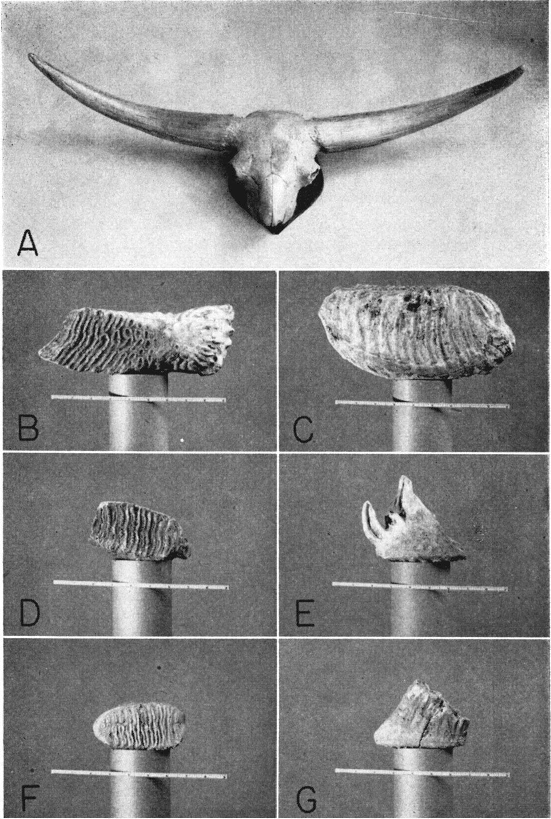
In 1940, a large fossil molar was unearthed by a W.P.A. crew at the same Geist (Christy) gravel pit. It was identified by Hibbard as a lower molar (M3) of Paraelephas cf. columbi (Pl. 15B and C). Another tooth that was unearthed at the Geist (Christy) gravel pit is shown in Plate 15D and E. Hibbard identified this tooth as an upper molar Paraelephas cf. columbi. A small tooth was unearthed from a gravel pit on the west side of Beaver (Ladder) Creek in the SE NE sec. 15, T. 17 S., R. 33 W. Hibbard identified this specimen as an upper premolar of Paraelephas cf. columbi (Pl. 15F and G).
Fragmentary teeth collected by me in 1940 from the Gilbert Lenz gravel pit in the SW NE 1/2 sec. 22, T. 17 S., R. 34 W. were subsequently identified by Hibbard as Procamelus, a Tertiary form. A fragment of a horse tooth, either Pliohippus or Hipparion was also identified. Because of the fragmentary condition of the material, exact identification was not possible.
The undifferentiated Pleistocene deposits have also yielded invertebrate fossils. Mollusks recovered from several of the test holes drilled in Scott County are listed below. Identifications were made by A. B. Leonard.
Mr. Leonard reported that all of these forms seemed to be well fossilized, but pointed out that fossilization in snails is sometimes very difficult to determine with accuracy. He also reported that Vallonia and Succinea exist in this part of Kansas today and therefore cannot be used to identify Pleistocene deposits.
The invertebrate fossils collected from the undifferentiated deposits in Scott County are additional evidence indicating Pleistocene age for these beds. Many of the mollusks given in the preceding list are identical with forms found in the Meade formation of Meade County (Frye and Hibbard, 1941, pp. 413-415) where they are associated with Pleistocene vertebrates. Similar invertebrate fossils were recovered from several of the test holes drilled in Finney and Gray counties (Latta, 1944, p. 175). Latta also called attention to similar forms collected by Thad G. McLaughlin from a bed of silty clay in the SE NE sec. 3, T. 27 S., R. 31 W., in the northeastern corner of Haskell County.
| Fossil material recovered from test holes in Scott County | ||
|---|---|---|
| Test Hole No. |
Depth below land surface (feet) |
Fossils |
| 2 | 3 - 14 | Vallonia costata; Lymnea parva; (aquatic, Recent). |
| 2 | 16 - 18 | Vallonia costata. |
| 3 | 11 - 18 | Lymnea rustica; Has been found in Kingman County (probably Recent). |
| 5 | 30 - 33.5 | Vallonia costata; Succinea grosvenori; Both terrestrial; both probably in the area today, questionable value. |
| 8 | 15 - 22 | Vallonia costata; see above. |
| 10 | 72 - 76 | Helisoma cf. trivolvis (fragment); A pond snail that is likely found in the area today. |
| 11 | 4 - 11 | Vallonia costata; Succinea grosvenori; Both terrestrial; both probably in the area today. |
| 12 | 2.5 - 14 | Vallonia costata; see above. |
| 13 | 180 - 190 | Lymnea sp.; The value of this form is lost because of its fragmentary condition which makes specific identification impossible. |
| 15 | 26 - 31 | Vallonia costata; see above. |
| 17 | 44 - 51 | Helisoma sp. (fragmentary); A pond snail. |
| 17 | 51 - 56 | Vallonia costata; see above. |
| 13 | 4.5 - 16.5 | Vallonia costata; Succinea grosvenori; Terrestrial forms—both probably Recent. |
| 19 | 11 - 16 | Succinea grosvenori. |
| 19 | 16 - 22 | Pupilla muscorum; Succinea grosvenori. |
| 19 | 22 - 26 | Pupilla muscorum; Vallonia costata. |
| 19 | 26 - 30 | Vallonia costata. |
| 19 | 37 - 39.5 | Gyraulus deflectus. |
| Pupilla muscorum, a woodland form, and Gyraulus deflectus, an inhabitant of permanent pools, are both extinct in this area, and suggest that the deposit is Pleistocene. | ||
| 20 | 53 - 58.5 | Vallonia costata; see above. |
| 22 | 20 - 24 | Lymnea parva; A pond snail, Recent? |
| 22 | 39 - 43 | Succinea grosvenori; Vallonia costata. |
| Although these snails seem to be well fossilized, their stratigraphic value is limited inasmuch as these forms seemingly live in the area today. | ||
| 23 | 1.5 - 12.5 | Vallonia costata. |
The presence of water-worn caliche and "mortar bed" pebbles also indicate Pleistocene age for these deposits in Scott County. As has been pointed out earlier, water-worn fragments of Ogallala material are common in the Pleistocene gravels.
Water supply—Many of the wells in the Scott Basin derive water from the undifferentiated Pleistocene deposits. Some wells penetrate these deposits as well as the water-bearing section of the Ogallala formation below and may obtain water from both sources. The terrace deposits found in isolated patches along the valley sides of Beaver (Ladder) Creek in the northwestern quarter of the county are relatively permeable but generally occur above the water table and are therefore not important as a source of water in that vicinity.
The yields of wells in the undifferentiated Pleistocene deposits range from several gallons a minute from small domestic and stock wells to more than 1,000 gallons a minute from some of the large irrigation wells. Where wells penetrate the Pleistocene deposits and the water-bearing beds in the underlying Ogallala formation, it is practically impossible to determine the quantity of water being furnished from each of the two sources. The thickness of saturated material in the Pleistocene deposits differs greatly, as shown by the profile sections in Figure 5. Logs of test holes show that a large percentage of the saturated zone in these deposits is composed of sand and gravel, so the amount of water available is believed to be 1arge.
Six samples of water were collected from wells (107, composite sample from 82 and 112, 174, 236, 252, and 262) obtaining water from undifferentiated Pleistocene deposits and/or the underlying water-bearing beds in the Ogallala formation. All of the wells were situated in the Scott Basin, in the vicinity of the deep buried trough where maximum thicknesses of Pleistocene deposits occur. The total dissolved solids in the six samples ranged from 205 to 563 parts per million, two of the samples (wells 174 and 236) having 563 and 536 parts respectively of total dissolved solids. The total hardness ranged from 172 to 344 parts per million and averaged 238 parts. The iron content in the six samples ranged from 0 to 3.3 parts per million, and the fluoride content ranged from 1.0 to 2.7 parts per million, four of the samples (wells 107, 236, 252, and 262) having 1 part or more of fluoride, and two samples (composite of wells 82 and 112, and 174) having 2.0 and 2.7 parts per million of fluoride, respectively. The sulfate content in all six samples showed a greater range in concentration - four of the six samples (wells 107, composite sample of 82 and 112, 252, and 262) had a sulfate content ranging from 26 to 41 parts per million. Samples of water from wells 174 and 236 had sulfate contents of 194 and 145 parts per million, respectively. The fluoride content in some of the water derived from the undifferentiated Pleistocene deposits and/or the water-bearing beds of the underlying Ogallala formation is relatively high. The composite sample collected from the public supply at Scott City (wells 82 and 112) at a time when both wells were pumping had a fluoride content of 2.0 parts per million.
The analyses of these six samples of water from the undifferentiated Pleistocene deposits and/or Ogallala formation in Scott County indicate that the water is well within the safe limits for use in irrigation according to the principles discussed by Scofield (1933).
Quaternary System—Pleistocene and Recent Series
Loess
A relatively thin deposit of loess overlies the undifferentiated Pleistocene deposits in much of Scott County. In places where the undifferentiated Pleistocene deposits are absent the loess may rest directly on the Ogallala formation. The loess is exposed in road and highway cuts in the northern half of the county; typical exposures of loess are shown in Plate 16. The loess is generally light buff to light brown but may grade upward into a darker brown to black soil zone at the top. The material is structureless and lacks bedding. Exposures of loess in road cuts are typical in appearance to loess found elsewhere, except that vertical parting may be less prominent. In places it contains small, scattered concretionary nodules of lime carbonate. It is composed principally of silt but contains some very fine sand. Mechanical analyses made by Smith (1940, p. 122) included analyses of two samples of loess (11 and 12) collected from road cuts near the north county line in northern Finney County. One sample was collected in the northwest corner of Finney County in the NW sec. 6, T. 21 S., R. 34 W., and the other in the NE sec. 2, T. 21 S., R. 29 W., near the Lane-Finney County line. These analyses (Table 17) indicated maxima in the 0.062-0.031 mm division. Fractions larger than 0.062 mm were separated by screening; those smaller than 0.062 mm were separated by the pipette method.
Table 17—Mechanical analyses of loess and associated materials. Modified from Smith (1940, p. 122).
| No. of Sample |
Location | Mechanical Composition | |||||
|---|---|---|---|---|---|---|---|
| 0.5 mm |
0.5-0.25 mm |
0.25-0.125 mm |
0.125-0.062 mm |
0.062-0.031 mm |
0.031 mm |
||
| 11 | NW sec. 6, T. 21 S., R. 34 W. | 0.2 | 0.7 | 5.2 | 26.2 | 52.0 | 15.8 |
| 12 | NE sec. 2, T. 21 S., R. 29 W. | 0 | 0.03 | 3.5 | 22.6 | 69.5 | 4.4 |
Natural exposures of loess are relatively few and small because of the incoherent character of the material. Because road cuts and other excavations are generally shallow, the complete thickness of the loess is not readily determinable and the irregularities of the buried pre-loess surface are concealed. It is estimated that the thickness of the loess in Scott County ranges from a few feet to about 30 feet. Most of the test holes in Scott County encountered deposits of loess that ranged in thickness from 5 to 28 feet. The maximum thickness was encountered in test hole 3. Gastropod shells were collected from an exposure of loess in an abandoned railroad cut in the northern part of the county in the NE NE sec. 36, T. 16 S., R. 33 W. (Pl. 16A). Gastropod shells and fragments of pelecypod shells were recovered from the upper part of most of the test holes drilled in Scott County, some of which came from the upper loessial part of the test holes.
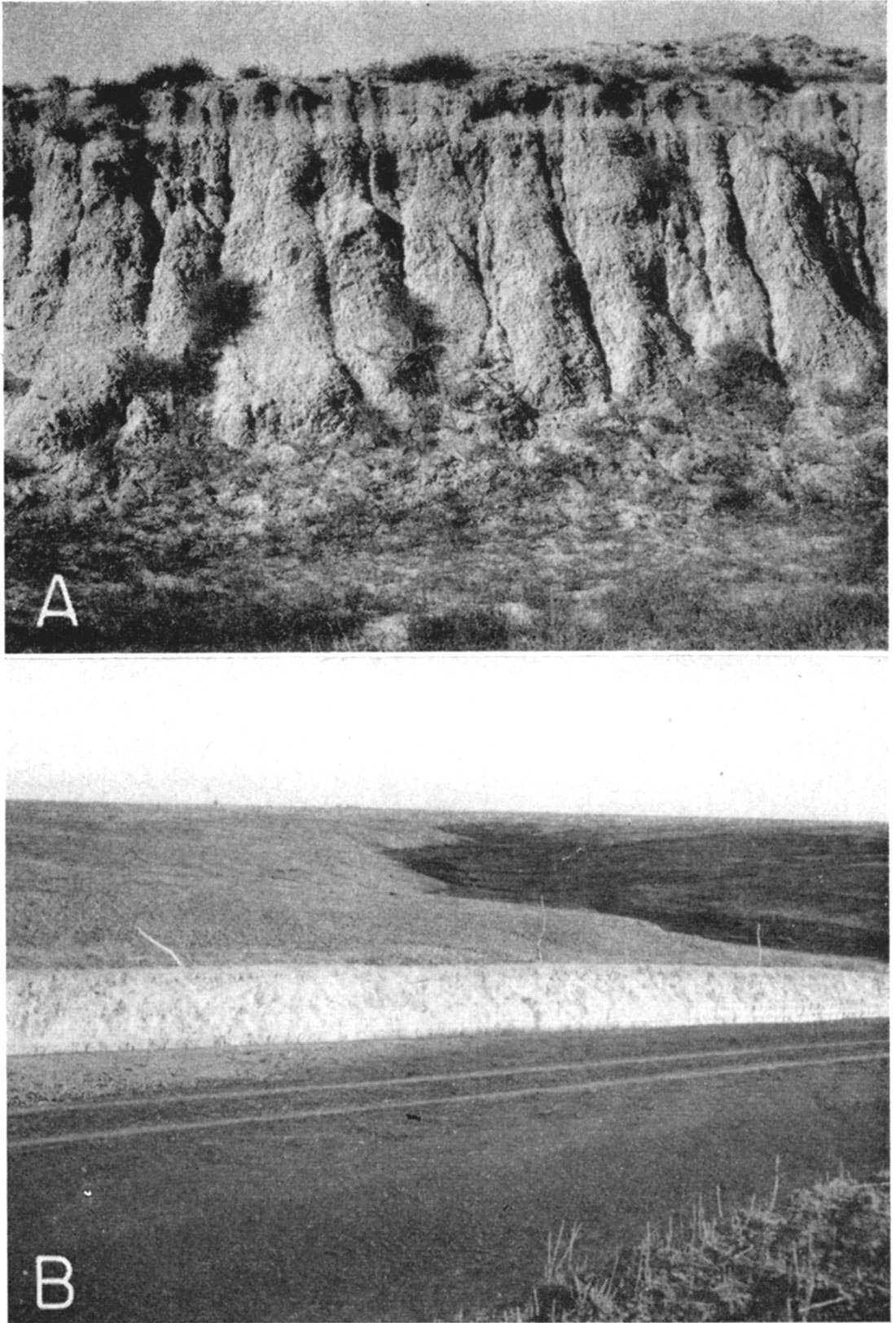
Plate 16—A, Typical loess exposed in abandoned railroad cut near the NE cor. sec. 36, T. 16 S., R. 33 W.; B, loess exposed on east side of freshly graded road in the SW cor. NW NW sec. 17, T. 16 S., R. 33 W.
The age of the loess can be stated only in relative terms, for as A. B. Leonard has pointed out, the fossilization of snails is sometimes very difficult to determine with accuracy, and some of the forms are of doubtful value because they exist in western Kansas today. At least in part, the loess probably belongs somewhere in the upper Pleistocene and may grade imperceptibly upward into loess of Recent age. It is younger than volcanic ash, and older than dune sand at the few localities where it is found in contact with one or the other of these, according to Smith (1940, pp. 124-125). He also suggests that it may be contemporaneous with and in part grade laterally into the Kingsdown formation. More than one age of loess may be present in Scott County, but no attempt was made to subdivide it. The loess lies above the water table in Scott County; hence, it furnishes no water to wells.
Dune Sand
Dune sand of Quaternary age occurs in an area of approximately 9 square miles in the southeastern corner of Scott County and in smaller scattered areas in the southeastern part of the county (Pl. 1). The dune sand is composed predominantly of uniform fine-to medium-grained well-rounded quartz sand and contains smaller amounts of silt and clay. The sand has been accumulated by the wind to form small hills and ridges. The exact thickness of this material in Scott County has not been determined, but it is believed that the dune sand mantle ranges in thickness from a few feet to perhaps as much as 50 feet. In places the soil zone is thin and attempts at cultivation have stripped the protective vegetative cover allowing the upper surface to be subjected to renewed wind action. The dune sand probably was derived from the denudation of nearby Pliocene and Pleistocene deposits. Smith (1940, pp. 127-128; 153-168) gives a detailed discussion of the origin of sand dunes in western Kansas.
No wells obtain water directly from the dune sand in Scott County, for it is everywhere above the water table, but sand dunes serve as valuable intake areas for ground-water recharge from local precipitation because the porous materials comprising them are highly permeable and permit infiltration readily.
Alluvium
Alluvium of late Quaternary age is found in Beaver (Ladder) Creek valley in Scott County (Pl. 1). Some of the tributary streams in the extreme northern part of the county are still in the process of downcutting so that there is little or no alluvium along the greater part of their courses in Scott County. Where present, the alluvium is thin and occurs as very narrow bands along the northern part of their present channels; accordingly, it is not shown on the geologic maps.
The character of the alluvium in Beaver Valley is typical of stream-laid deposits and ranges in texture from silt to sand and coarse gravel. The youngest deposits consist largely of sand and silt deposited over the floodplain in time of flood or in normal conditions in the channel of the stream. Beneath the finer surface deposits are layers of sand and gravel slightly older but of similar origin. The alluvium grades into the terrace deposits, so the lower part of the valley fill in some places is of late Pleistocene age and represents the basal part of a cut and fill terrace deposit.
The alluvium is underlain by the Ogallala formation in most parts of Beaver Creek Valley, but in the vicinity of Scott County State Park the alluvium rests uncomformably on the Niobrara formation. Scanty data indicate that the thickness of the alluvium along Beaver Valley ranges from a few feet to an estimated maximum of about 20 feet. The yields of wells tapping the alluvium in Beaver Valley generally are adequate for domestic and livestock purposes.
The analysis of one sample of water (3) collected from a well in shallow alluvium of a tributary drainage in the northeastern part of the county in the SW NW sec. 4, T. 16 S., R. 31 W. showed dissolved solids, 462 parts per million; total hardness, 394 parts; sulfate, 171 parts; fluoride, 1.0 part; and iron, 2.1 parts. The well from which the water was collected is in an area in which the Niobrara formation is at or near the surface and the chemical quality of the water in the alluvium in that vicinity is doubtless affected somewhat by the underlying chalk of that formation.
Prev Page—Chemical Character || Next Page—Water Levels
Kansas Geological Survey, Geology
Comments to webadmin@kgs.ku.edu
Web version March 2003. Original publication date July 1947.
URL=http://www.kgs.ku.edu/General/Geology/Scott/06_form.html