![]()
Prev Page--Stratigraphy || Next Page--Permian System
Stratigraphy, continued
Carboniferous System--Pennsylvanian Subsystem
The table shows the series and groups now recognized by the Kansas Geological Survey as constituting the Pennsylvanian subsystem in Kansas.
Table 3--Pennsylvanian Subsystem in Kansas
| Pennsylvanian Subsystem | |||
| Virgilian Series | |||
| Wabaunsee Group | |||
| Shawnee Group | |||
| Douglas Group | |||
| Missourian Series | |||
| Pede Group | |||
| Lansing Group | |||
| Kansas City group | |||
| Bronson group | |||
| Bourbon group | |||
| Des Moines Series | |||
| Marmation Group | |||
| Cherokee Group | |||
The groups are divided into formations and many of the formations into members. The classification used in this report is in accordance with that recently established by R. C. Moore (1936).
Virgilian Series
The Virgil was introduced by Moore (1932) for the uppermost series of the Pennsylvanian rocks in the northern midcontinent region. The name is derived from a town in eastern Greenwood County, Kansas. The series comprises in ascending order three groups, called Douglas, Shawnee, and Wabaunsee. The upper part of the last group is poorly exposed in southeastern Riley County.
Wabaunsee Group
The name Wabaunsee was introduced as a formation name by Prosser in 1895 (p. 68S). He fixed the lower boundary of the formation at a coal bed, which is identified as either the Nodaway coal in the Howard limestone or the Elmo coal in the Cedar Vale shale. Prosser thought these two to be the same, but Condra (1927, p. 60) has shown them to be separate strata ore than 100 feet apart. Prosser placed the upper boundary of the Wabaunsee at the base of the Cottonwood limestone, but now the term Wabaunsee as used by the Kansas Geological Survey includes all beds between the top of the Topeka Limestone and the base of the Indian Cave Sandstone in the Towle Shale. Hence the base and the top of the group are many feet lower than the formational boundaries originally defined. The group includes the following formations in ascending order: (1) Severy Shale, (2) Howard Limestone, (3) White Cloud Shale, (4) Happy Hollow Limestone, (5) Cedar Vale Shale, (6) Rulo Limestone, (7) Silver Lake shale, (8) Burlingame limestone, (9) Soldier Creek shale, (10) Wakarusa Limestone, (11) Auburn Shale, (12) Reading Limestone, (13) Harveyville Shale, (14) Elmont Limestone, (15) Willard Shale, (16) Tarkio Limestone, (17) Pierson Point Shale, (18) Maple Hill Limestone, (19) Table Creek Shale, (20) Dover Limestone,(21) Dry shale, (22) Grandhaven Limestone, (23) Friedrich Shale, (24) Jim Creek Limestone, (25) French Creek Shale, (26) Caneyville Limestone, (27) Pony Creek Shale, and (28) Brownville Limestone. The upper portion of the Auburn Shale is the lowest stratigraphic unit exposed in Riley County, and the Pennsylvanian strata above the Dover limestone have almost everywhere been removed by erosion that occurred at the end of Pennsylvanian time or they are now concealed by younger deposits, especially by Recent alluvium.
Auburn Shale
According to present usage the Auburn Shale includes the strata between the Wakarusa and the Reading limestone formations (Moore, 193 , p. 222).
The stratigraphically lowest rock that is exposed in this area crops out along and east of a public road south of Deep Creek in the northeast part of sec. 29, T. 10 S., R. 9 E., and in the adjacent northwest part of section 28 of the same township and range. About 12 feet of shale may be seen below the Reading limestone, and because of its position this shale is believed to be the upper part of the Auburn shale.
Lithologic character and distribution--The shale that is here identified as part of the Auburn is gray, and the upper part of 12-foot section exposed is darker than the lower part. The outcrop is deeply weathered and few facts concerning the nature of bedding can determined there. The overlying Reading limestone can be traced from the northeast part of sec. 27, T. 10 S., R. 9 E., to a point near the southeast corner of section 32 of that township and range, but throughout most of this distance of about 3 miles the shale is covered with alluvial material of recent deposition.
Detailed sections--A section of the Auburn beds just mentioned is given at the end of this report (section 52).
Reading Limestone
The term Reading limestone formation is now applied to a limestone that was formerly included in the "Emporia limestone," a term that is no longer used. The name is that of a town in northeastern Lyon County, Kansas.
The Reading limestone is exposed above the alluvium of Kansas River and of Deep Creek in the very small area designated in the discussion of the occurrence of Auburn shale in this area. In as such as this area is isolated as a part of an inlier, the correlation is based upon the lithologic character of the rock and upon its position as the second limestone below the more easily recognized Tarkio limestone.
Lithologic Character and Thickness--The rock to which the name Reading limestone is here applied is a dense to very slightly crystalline hard massive limestone that breaks with conchoidal fracture. It seems to be more compact in the lower part. in fresh exposures it is generally brown in the upper part and bluish gray in the lower part, but more gray than brown is shown. Crinoid stems are the only conspicuous fossils. The thickness is approximately 2 feet.
Distribution--The Reading limestone is exposed in this area in Deep Creek valley in the inlier formed by the erosion of the broad valley of the creek across an anticline. The formation is exposed only on the right side of the stream and the line of outcrop can be traced from sec. 27 to sec. 32, T. 10 S., R. 9 E. It is shown on the areal geological map that forms a part of this report.
Detailed sections--The Reading limestone is described in sections 52 and 54 at the end of this report.
Harveyville Shale
A shale unit formerly included in the Emporia Limestone is now called Harveyville, being named for Harveyville station on Atchison, Topeka, and Santa Fe Railway in the Burlingame quadrangle, Wabaunsee country, Kansas.
Lithologic Character, Thickness, and Distribution--the shale unit believed to be the Harveyville shale is about 20 feet thick in this area, and is greenish-gray below, yellow in the middle part, and gray above. near the top are small calcareous limonitic concretions about the size of peas. The measurement of thickness may be somewhat inaccurate, as the overlying limestone may be slumped wherever seen. The shale is exposed in secs. 27 and 28, T. 10 S., R. 9 E., and mile east of Zeandale in Riley County on the south side of Deep Creek. In sec. 33, T. 10 S., R. 9 E., it is covered with soil, but forms steep slopes between the exposed limestone layer that bound it. No fossils were observed and none are believed to be contained in it.
Detailed sections--For sections of the Harveyville shale see numbers 52, 54, 61, and 62 at the end of this report.
Elmont Limestone
According to usage of the Kansas Geological Survey the upper limestone unit of the old "Emporia limestone" is called Elmont, the name being derived from a village of that name in Shawnee country, Kansas.
The name Emporia was introduced as a stratigraphic term by Kirk in 1896, but he did not indicate clearly what strata he intended to include in the unit named. Condra (1927, pp. 78-79) has shown limestone and he stated that the thickness ranges between 6 and 9 feet. Inasmuch as the Tarkio limestone is well exposed and can be identified without hesitation in this area and inasmuch as it lies approximately 30 feet above the unit herein described it seems that this unit is the upper part of the "Emporia." North of Kansas River and short distance east of Deep Creek valley is an exposure of approximately 150 feet of strata capped by Tarkio limestone. In that exposure, which is situated in Pottawatomie County, the bed here discussed lies about 55 feet below the Tarkio limestone and has the same lithologic characters as in Deep Creek valley. the Reading, Harveyville, and Elmont formations are differentiated as distinct stratigraphic units because of observations showing deposition in separate marine inundations of the Kansas region.
Lithologic Character and Thickness--This unit is a very brittle blue-gray to almost black limestone locally containing calcite crystals. It breaks with wavy, irregular fracture and commonly occurs in beds about 7 inches but locally it is as little as 12 inches. The limestone contains an abundance of small fusulinids and locally contains fragments of other fossils.
Distribution--The Elmont limestone is exposed in Deep Creek valley south and east of Zeandale in Riley County, in secs 27,28,32, and 33,10 S., R. 9 E., and in secs. 5 and 6, T. 11S., R. 9 E. In several places in the last two sections enumerated, the limestone gives origin to small waterfalls in Deep Creek. Along the creek it is either faulted or slightly folded. It forms the natural ford at Pillsbury Crossing in sec. 5, T. 11 S., R. 9 E.
Detailed sections--For sections showing the Elmont limestone see numbers 52, 54, 61, and 62 at the end of this report.
Willard Shale
The Willard formation, named from a village in Shawnee County, Kansas, was differentiated by Beede in 1898. In some reports of the Kansas Geological Survey an error in correlation of units appears, but the Willard is now recognized as the shale between the Elmont and Tarkio limestones. According to Condra (1927, p. 79) it is composed of bluish and reddish argillaceous shale, some calcareous material, and some sand.
Where exposed in Riley and Geary counties, the strata below the Tarkio limestone and above the Elmont limestone comprise approximately 30 feet of shale, which is mostly argillaceous or entirely argillaceous except for a few thin arenaceous beds about 8 feet from the top.
Lithologic Character and Thickness--Gray shale, argillaceous and sandy as stated, comprises the unit where exposed in Riley County. The thickness is approximately 30 feet.
Distribution--This shale is exposed in a small area on both sides of Deep Creek in southeastern Riley County. It can easily be seen at Pillsbury Crossing in sec. 5, T. 11 S., R. 9 E. Its upper boundary is shown on the geologic map as the line that marks the base of the Tarkio limestone formation. Its area of outcrop is very narrow because there is everywhere a steep slope between the two limestones.
Detailed sections--Sections 52, 54, 60, 61, and 62 at the end of the report show the character and stratigraphic relations of the Willard Shale.
Tarkio Limestone
The name Tarkio was introduced as a stratigraphic name by Calvin (1900, p. 416) Moore (1936, pp. 229-230) has explained that the formation long called Tarkio in Kansas is not equivalent to the rock along Tarkio creek in Page Country, Iowa, but long usage of the name for the limestone here described makes its retention desirable. Moore has designated a typical exposure of the Tarkio limestone on Mill Creek, southwest of Maple Hill, Kansas.
Plate 12A--An exposure at Pillsbury's Crossing on Deep creek, sec. 5, T. 11 S., R. 9 E., Riley County. Elmont limestone at base, Tarkio limestone at top.
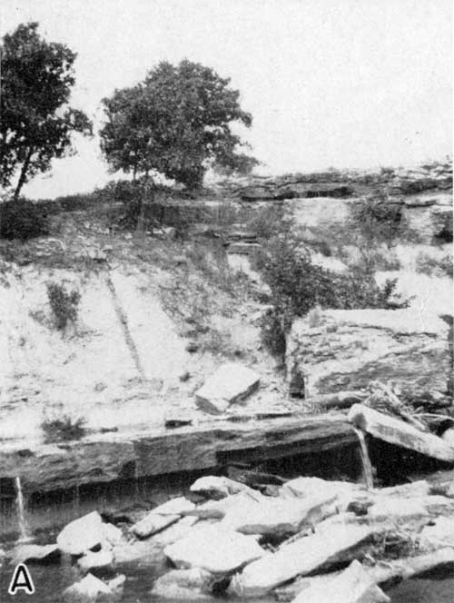
Lithologic Character and Thickness--In Riley County the Tarkio limestone is conspicuous, forming cliffs that are bold for a limestone of this thickness. It is brownish gray and commonly consists of two massive beds. Very robust fusulinids, Triticites ventricosus, stand out on weathered surfaces and impart a rasp-like appearance. Where best exposed the limestone is seen to consist of two beds, each approximately 6 feet thick. The limestone beds are separated by a shaly zone ranging from a few inches to a foot or more in thickness. Upon weathering, the rock assumes a strong rusty-brown color and the fusulinids are locally even darker than other parts of the rock. large blocks slumped upon the Willard shale slope characterize the exposures.
Distribution--The Tarkio limestone forms a bench and bold cliff on each side of Deep Creek southeast of Zeandale and is exposed along the east-west road in sec. 29, T. 10 S., R. 9 E.; along the north-south road in the southeast part of the same section; along the cliff that crosses secs. 27, 28 and 33, T. 10 S., R. 9 E.; at Pillsbury's Crossing, which is near the northwest corner of sec. 5, T. 11 S., R. 9 E.; along a small northward flowing creek tributary to Deep Creek south of the center of the last named section, and at intervening points.
Detailed sections--For sections of the Tarkio limestone, see numbers 52, 53, 54, 60, 61, 62, and 63 at the end of this report.
Pierson Point Shale
The Pierson Point shale, now recognized as a formation of the Wabaunsee group, was named as a subdivision of the "McKissick Grove shale member" of the "Wabaunsee formation" by Condra (1927, p. 80). It was defined as lying above the Tarkio limestone and below the Maple Hill limestone. The term McKissick Grove, which had been introduced by Smith (1908, p. 641) was redefined by Condra to include strata between the top of the Tarkio limestone and the base of the Brownville limestone. The McKissick Grove unit is no longer regarded as a useful subdivision of Kansas stratigraphy.
According to Condra the Pierson Point, shale is 8 to 10 feet thick in Kansas and Nebraska and consists of bluish argillaceous shale and some sand. The lower portion is locally almost black.
Lithologic Character and Thickness--In the northwest part of sec. 27, T. 10 S., R. 9 E., in eastern Riley County the strata between the Tarkio limestone and the Maple Hill limestone are well exposed, and consist of 16 feet of light-gray to bluish-gray shale containing limonitic concretions. The bedding is noticeably irregular. In other poorer exposures it is about the same. Yellow is noticeable in weathered surfaces.
Distribution--Although well exposed in only a few places, the unit is present above the cliff-forming Tarkio limestone on each side of Deep Creek east and south of Zeandale.
Detailed sections--The Pierson Point shale is included in sections 52, 53, and 63 at the end of this report.
Maple Hill Limestone
The first limestone bed above the Tarkio limestone was named Maple Hill from the town in northeastern Wabaunsee County, Kansas, by Condra (1927, p. 80) who indicated that an exposure in Maple Creek about 2 miles southwest of Maple Hill is the type exposure. The formation is described as bluish-gray limestone ranging in thickness from 2 to 4 feet.
Lithologic Character and Thickness--The exposures of Maple Hill are few in its small area of outcrop in eastern Riley County; however, the formation can be studied easily in a few places such as a point near the northeast corner of sec. 28, T. 10 S., R. 9 E., where it is exposed about 17 feet above the massive, cliff-making Tarkio limestone. It is bluish-gray to yellow and weathers brown. Freshly exposed surfaces have a mottled, granular appearance and show numerous small calcite cleavage faces. The formation contains "cryptozoans" and small fusulinids, most of which weather lighter in color than the matrix. The thickness of the formation is about 1.5 feet.
Distribution--The exposures of Maple Hill limestone are not far from those of the Tarkio except on the east side of Deep Creek, where the distance between the outcrops is almost a mile. The base of the Maple Hill formation is mapped.
Detailed sections--For details of the Maple Hill limestone where it can be studied in Riley County see sections 52, 53, and 63 at the end of this report.
Table Creek Shale
The Table Creek shale is defined as including the strata between the Maple Hill and Dover limestones. The formation was named by Condra (1927, p. 80). He regarded the stratigraphic unit as a subdivision of the "McKissick Grove" shale, a larger group that does not seem to be a natural unit in Kansas. The type exposure is near Table Creek, Neb.
Lithologic Character and Thickness--The Table Creek shale is concealed under steep sod-covered slopes along a line a few miles in length in the lower valley of Deep Creek south and southeast of Zeandale in Riley County and is actually exposed in only a very few places. In sec. 6, T. 11 S., R. 9 E., it is greenish-gray clay shale containing nodular, probably algal, calcareous material in the upper and lower parts. The deep-green color is especially noticeable near the top of the formation. In sec. 28, T. 10 S., R. 9 E., the lower 6 feet is exposed and there the calcareous material is absent and only gray clay shale is present. The thickness is almost uniformly 16 feet. Moore (1936, p. 234) found the thickness to be 50 feet or more in Wabaunsee County. The decreased thickness in Riley County is consistent with the general thinning of shale units in the anticlinal structures above the buried granite hills of the Nemaha Mountains that underlie parts of the Riley and Geary county district.
Distribution--The Table Creek shale is present but mostly concealed under a steep grass-covered slope along the bluffs of Deep Creek in southeastern Riley County. Its upper boundary is shown on the geologic map.
Detailed sections--Measured sections, in which the Table Creek shale formation is included, are numbers 52, 53, and 63 at the end of this report.
Dover limestone
The name Dover, from the town of that name in western Shawnee County, Kansas, was introduced as a stratigraphic term by Beede (1896, p. 31). The Dover limestone is now recognized as a formation. Moore (1936, p. 236) has found the Dover limestone to be 2 to 4 feet thick in northern Kansas but as much as 20 feet thick in southern Kansas. In small exposure in Riley County the thickness is about 2 feet, but it is not certain that the entire formation is observable.
Lithologic Character and Thickness--Where best exposed in Riley County the Dover limestone is light gray and crystalline and contains many fusulinids and small fragments of other fossils. It weathers into characteristic irregular slabs and makes a bench in the bluffs above the cliffs of Tarkio limestone. The observed thickness of about 2 feet may not represent the entire thickness.
Distribution--The Dover limestone formation is present at the surface in Riley County in a small area along the valley of Deep Creek in the southeastern part of the county.
Detailed sections--See numbers 52, 53, 63, and 64 at the end of this report.
Dry-Freidrich (?) shale
The formation overlying the Dover limestone, called the Dry shale, was named by Moore (Moore, Elias, and Newell, 1934). The upper boundary is, by definition, the base of Grandhaven limestone.
Between the Grandhaven limestone and the Jim Creek limestone lies the Friedrich shale (Moore, Elias, and Newell, 1934). Moore (1936, p. 236) has found that from Shawnee County, Kansas, northward the Grandhaven limestone is absent and hence it does not separate the two shale formations.
My observations in southeastern Riley County, wherever these and associated beds crop out, verify the absence of the Grandhaven formation and hence the two shale formations are not differentiated there.
Near the Riley-Wabaunsee county line in Riley County in sec. 9, T. 11 S., R. 9 E., the base of the Indian Cave sandstone is approximately 80 feet above the Dover limestone formation. The lower 65 feet of strata overlying the Dover seemingly contains no limestone, and is believed to be Dry-Friedrich shale. In only this one locality are these strata exposed at the surface. On the west side of the same valley the alluvium covers almost everything below the Brownville (?) limestone upon which the Indian Cave sandstone lies. In an outlier of Indian Cave and other beds in sec. 29, T. 10 S., R. 9 E., the disconformity representing erosion prior to the deposition of the sandstone reaches downward to the Dover formation, the beds discussed here having been removed.
Lithologic Character and Thickness--As already explained, the Dry-Friedrich (?) shale reaches the surface in a very small area and it is almost covered by soil, but the gentle slope and local exposures indicate a shale having a thickness of about 64 feet. This thickness may be somewhat too great, owing to possible error in measuring due to dip of the beds.
Distribution--The beds referred to the Dry-Friedrich shale are present below soil cover in a small area along the east side of Deep Creek valley in southeastern Riley County.
Detailed sections--See number 64 at the end of this report.
Jim Creek (?) limestone
Moore (1936, p. 239) has given the name of Jim Creek to the persistent limestone that lies between the Grandhaven or Dover limestone below and the Caneyville limestone above. The type exposure is in sec. 29, T. 7 S., R. 11 E., in Pottawatomie County, Kansas. As already stated, I believe the Grandhaven limestone to be absent in southeastern Riley County and have identified the approximately 64 feet of shale above the Dover limestone as Dry-Friedrich shale, believing that the limestone overlying these shale beds is the Jim Creek. The conclusions are based on very limited observations, owing to the lack of actual exposures and the fact that these beds crop out in an inlier and can be traced only into mantle deposits or into the disconformable Permian beds above. Determination of exact relationship of the Pennsylvanian beds above the Dover limestone in the small area must await preparation of better exposures by road construction or other workings, and very careful study of beds in the same zones farther eastward in Wabaunsee County.
Lithologic Character and Thickness--The limestone in southeastern Riley County believed to be the Jim Creek limestone can be seen in a road-side exposure in sec. 9, T. 11 S., R. 9 E. There is exposed a bed of crystalline limestone less than 3 inches thick, overlain by about 1 foot of shale, which is concealed by soil. The next higher bed consists of less than 1 inch of limonitic soft limestone or mudstone, overlain by 2.5 feet of yellow shale, which is overlain by about 6 inches of bluish-brown, nodular limestone bearing "Osagia" and cryptozoans. The total measured thickness of these beds is 3.55 feet.
Distribution--Like the underlying Dry-Friedrich (?) shale, this formation is exposed only in the small area east of Deep Creek.
Detailed sections--see number 64 at the end of this report.
French Creek (?) shale
Moore (1936, p. 240) has named the shale between the Jim Creek and Caneyville limestone formations the French Creek and has given it formational rank. The name is obtained from French Creek in northeastern Pottawatomie County, Kansas.
Lithologic Character and Thickness--About 10 or 15 feet of shale below the disconformable base of the Indian Cave sandstone in a very small area in southeastern Riley County is believed to correlate with the lower part of the French Creek formation. The shale is poorly exposed but is principally gray and yellow clay.
Distribution--The French Creek (?) shale is exposed in a small area in the east wall of Deep Creek valley.
Detailed sections--See number 64 at the end of this report.
Caneyville-Pony Creek Beds
The base of the Permian system is disconformable in this area, so the base of the Indian Cave sandstone, which is the base of the Permian system, rests upon different beds.
Among the beds believed to have been removed from exposed areas are the upper part of the French Creek shale, all the Caneyville limestone, and the lower part of the Pony Creek shale. In an exposure near the middle of sec. 30, T. 10 S., R. 9 E., about 3 feet of yellow and gray calcareous shale below the Brownville (?) limestone is believed to be the upper part of the Pony Creek shale.
It is not possible to determine the thickness of the beds that are covered by alluvium on one side of Deep Creek valley and removed by erosion on the other side as indicated by the disconformity, but from the regional altitude of strata it seems probable that the thickness is between 10 and 20 feet.
Brownville (?) limestone
The uppermost formation of the Pennsylvanian subsystem, as now recognized in Kansas, is the Brownville limestone, which was named by Condra and Bengston (1915, p. 17) from exposures in the Missouri river bluffs south of Brownville, Nemaha County, Kansas. The formation is widespread and has been traced by Moore from Nebraska across Kansas and 50 miles or more into Oklahoma. Moore (1936, p. 245) reports the thickness as ranging from 2 to 8 feet.
This is believed to be the limestone exposed in a very small area in southeastern Riley County a short distance west of the middle of sec. 30, T. 10 S., R. 9 E. The formation there exposed underlies the Indian Cave sandstone, the basal unit of the Permian System. The outcrop can be followed for only a few yards where it is not concealed by surficial deposits. This exposure is situated at the junction of Kansas River valley and an abandoned alluvium-filled stream valley west of the present valley of Deep Creek. In an outlying exposure of Permian strata slightly more than a mile to the eastward, in sec. 29, T. 10 S., R. 9 E., the Indian Cave sandstone lies upon or almost upon the Dover limestone formation, which is stratigraphically about 75 feet below the Brownville. Farther southeastward, in sec. 9, T. 11 S., R. 9 E., the Indian Cave sandstone lies 10 or 15 feet above a limestone that is tentatively correlated with the Jim Creek. These data indicate the disconformable relationship between the Indian Cave sandstone and the upper Pennsylvanian beds.
Lithologic Character and Thickness--The Brownville (?) limestone, as exposed in the very small area described, is deeply weathered and hence the exact thickness is not determinable, but it seems to be approximately 5.5 feet. The exposure shows, at the base, about 2 feet of limestone that weathers brown but is gray and brown where unweathered. The limestone is earthy to crystalline in texture and contains a few Chonetes granulifer, Marginifera wabashensis, and fusulinids. Overlying the limestone is about 3 feet of greenish-gray fissile and flaky shale, overlain by approximately 6 inches of limestone, which is probably an algal limestone.
Distribution--As stated above, the formation reaches the surface only in a very small area in sec. 30, T. 10 S., R. 9 E., in northeastern Riley County, and is questionably correlated with Brownville limestone.
Detailed sections--See number 51 at the end of this report for a detailed section including the Brownville limestone.
Prev Page--Stratigraphy || Next Page--Permian System
Kansas Geological Survey, Geology of Riley and Geary Counties
Web version Nov. 2000. Original publication date Dec. 1941.
Comments to webadmin@kgs.ku.edu
The URL for this page is http://www.kgs.ku.edu/General/Geology/Riley/strat02.html