![]()
Prev Page--Structural Geology || Next Page--References
Economic Geology
Soils
The natural resources of greatest value in Riley and Geary counties are the soils. Soil is derived primarily from disintegrating rock, hence the properties of the soils depend upon the rock from which the soils are derived. A large part of this area, however, is covered with a mantle of soil that was not derived from rocks that disintegrated where the soil now is found. In other words, many soils are not residual, but have been transported from a distance and hence are called transported soils. Materials comprising such soils have been moved by running water, wind, creeping ice, or even by the pull of gravity down steep slopes. Of the eight types of soil mapped by the United States Department of Agriculture (Carter and Smith, 1908) in Riley County, only two are called residual, the other six being regarded as transported. It is plain, however, that the underlying rock does have an important bearing on the agricultural productivity of a large part of the two counties.
Soil is composed of particles of rock in various stages of decomposition, matter derived from the decay of organisms, low forms of plant and animal life, and gases. Hence a soil may well be regarded as a mineral framework, the particles of are coated with matter, much of which is probably colloidal. No doubt there are many controlling factors that determine the qualities of a soil. Climate must be very important and it is plain that the composition of the parent rock is only one of many factors. The components of transported soils characteristically are sorted or selected as to kinds of material or as to grain size within certain limits. The water-deposited soils are principally composed of sand or even gravel whereas wind-deposited loess consists of silt and clay or extremely fine sand.
In the two counties residual soil produced chiefly by the weathering of shales is the most important in number of acres covered. Associated with it is soil derived from weathered limestones. This to is residual, but it is stony and hence poorly suited to agriculture. In number of acres covered, this stony soil is perhaps second. This is the type that supports the extensive pastures in the Flint Hills and occasions the name "Blue-stem belt." The more tillable residual soil derived from shales is almost confined to the area above and west of the Flint Hills; the stony residual soil to the Flint Hills; the wind-deposited loess, by superposition, to the steep slopes; and the water-deposited soils to the river valleys, but at least small areas of each of these soils are found in all parts of the two counties. In fertility the soils of the stream valleys, which specialists divide into several types, perhaps rank first, and the loess ranks second. The alluvial soils in the valleys of the major streams are very different from those in the valleys of the smaller creeks. In the latter, much of the soil has been produced by the weathering of near-by rock and by the erosion of loess from the valley walls or near-by areas. In part, this creek-bottom soil is colluvial rather than alluvial.
The soils of the two counties may be roughly correlated with the topography and classified with it as (1) that of the uplands, (2) that of the valley walls, including the superposed loess, and (3) that of the river valleys. Upland soil is adapted to cultivation of small grain, corn, alfalfa, sorghums, and prairie hay; stream valley soils are adapted to production of corn, alfalfa, and truck corps according to the soil types; valley walls are generally uncultivated but are valuable grazing lands. Loess is suitable for growing vegetables and small fruits, but is commonly utilized in growing general farm crops.
Building Stone
Abundant limestone suitable for building stone is available in the two counties. Only a small amount is being quarried, but great quantities have been quarried in the past. The Cottonwood, Fort Riley, and Neva limestones have been most extensively quarried, although a few others, such as the Falls City limestone, have been used locally and Cottonwood limestones have been quarried in great quantities in and near Manhattan. Most of the buildings of Kansas State [University] are made of these rocks, principally of Cottonwood limestone. At Junction City and at Fort Riley much Fort Riley limestone has been used in buildings. There are now more suitable quarry sites along the exposure of Fort Riley limestone than along the exposures of the other workable ledges. Cottonwood limestone is the most satisfactory for use as building stone; Fort Riley limestone is perhaps second. Flinty limestones in the Wreford formation and Florence limestone are not suited to the making of dimension stones. Massive, non-flinty ledges in the Wreford formation, and massive ledges in the Cresswell limestone afford much material suitable for building stone. In southeastern Riley County the Eiss limestone member of the Bader formation is suitable for building blocks.
Limestone for Other Purposes
Limestone is put to many uses other than the fashioning of building blocks. It is one of the raw materials from which various kinds of cement are manufactured; it is used as a flux in blast furnaces and in metallurgy; it is used in the making of lime, agricultural limestone, concrete aggregate, ballast, and riprap and rubble; its products are used for refining sugar, manufacturing refractories, paper, and glass, and for making whiting and fillers. It is one of the materials in filter beds. There are great quantities of limestone in the two counties and undoubtedly much of it is adapted to some of these uses. At present much limestone is being quarried and crushed for use as road metal.
Clay
Clay in the form of shale and loess is available in great abundance in Riley and Geary counties, and although the material is not being used for industrial purposes it is perhaps well adapted to some uses.
Raw Material for Cement Manufacture
Portland cement is made from limestone or some other form of calcium carbonate, clay or shale, and a comparatively small amount of gypsum. The first two, which are the important raw materials, are present in the two counties in almost, unlimited quantity. Many years ago cement was made at Manhattan, but the plant Was dismantled long ago. Cement, like other bulky products made from cheap raw material, can be made at a profit only near a sufficient market. Should there be an increase in the demand for cement, owing to extensive paving or other uses, quarry sites are available near adequate shipping facilities. Of course, the raw material should be tested before extensive plans are made. As in the taking of other earth materials from an open mine, in the quarrying of limestone and shale for cement-making the amount of overburden that must be removed is an important factor, but the topography of Riley and Geary counties is such that numerous sites are available in which the removal of overburden would not be expensive.
Raw Material for the Manufacture of Rock Wool
Rock wool is a mass of fibers formed by passing air or steam through a stream of molten rock material of proper composition. The molten material is broken into small droplets by the blast of steam or air and the droplets are drawn out into fine threads as they are propelled through the air. The threads freeze into glassy fibers. According to Landes (Plummer, 1937, p. 5) rock wool is composed of silica and lime in approximately equal proportions. Alumina may be present with the silica, and magnesia with the lime, but neither of these two oxides is essential. The chief use of rock wool is for heat insulating.
A few years ago Norman Plummer, ceramic geologist of the Kansas Geological Survey (Plummer, 1937), investigated the rock wool resources of Kansas. He collected samples from all the promising rock formations in the state and from widely scattered areas. The samples were tested in an experimental plant at the University of Kansas. Plummer's report shows that the resources of the state in raw materials suitable for making rock wool are almost unlimited. Artificial mixtures of limestone, shale, loess, and alluvial clay were found to be satisfactory. Some Kansas rocks are natural "woolrocks," containing the proper mixture of lime and silica.
Plummer (1937, pp. 41-43) tested samples collected in Geary County in the SW 1/4 sec. 21, T. 12 S., R. 5 E., southwest of Junction City. A very fine, white wool containing only a small amount of shot was made from a mixture of Florence limestone, Oketo shale, Fort Riley limestone, and alluvial clay. A somewhat coarser wool was blown from the Florence limestone without additional material. It is probable that the Florence limestone could be used as a natural "woolrock" if a temperature somewhat higher than that employed for the test were used (Plummer, oral communication).
In Kansas the fuel best adapted for making rock wool is natural gas. In Riley and Geary counties pipelines connect the principal cities with the large gas fields farther southwest in Kansas.
Coal
With the exception of a very thin seam of coal in the lower part of the Permian beds in eastern Riley County, no coal was seen during the course of my field studies in the two counties. Hay (1896, pp. 17 and 21) reported a seam of coal 12 inches thick exposed at one place on Humboldt Creek and another, slightly lower stratigraphically, a few miles away. According to his sections the horizon of the one bed seems to be not far from the base of the Wreford formation. Unfortunately he did not state an exact location, and although 1 have seen many good exposures of the base of the Wreford formation and of the strata above and below that horizon, I saw no coal. The coal reported by Hay must be very local in occurrence. The coal seen by me in eastern Riley County is so thin that it is not economically important.
Oil and Gas
Subsurface Rocks--On previous pages I have discussed only those rocks that are exposed in Riley and Geary counties. It may be noted from the discussion and from the correlated stratigraphic sections and from the geologic map that the rocks cropping out in the eastern part of the area are the older ones, and that farther west they are buried under younger rock layers. The oldest rock exposed--Auburn shale--crops out in one small area in the extreme eastern part of Riley County and the youngest of the bed rock formations--Cretaceous sandstone--occurs at the surface in the northwest corner of Riley County (geologic map, pl. 1, and pls. 5-10). Rocks still older are exposed in eastern and southeastern Kansas, in the Ozark region in Missouri, in the Arbuckle Mountains in southwest Oklahoma, and in other more remote areas. Table 4 lists the larger divisions of subsurface rocks in Riley and Geary counties. These beds contain the potential oil and gas reservoirs of the area.
Table 4--Subsurface rocks of Riley and Geary counties, Kansas.
| Carboniferous system | Approx. thick. (ft) |
||||
| Pennsylvanian subsystem | |||||
| Virgil series | |||||
| Wabaunsee group | |||||
| Shale, limestone, and sandstone | 575 | ||||
| Shawnee group | |||||
| Shale, limestone, and sandstone | 320 | ||||
| Douglas group | |||||
| Shale, sandstone, and limestone (unconformity) | 50 | ||||
| Missouri series | |||||
| Pedee group | |||||
| Shale and limestone | |||||
| Lansing group | 335 | ||||
| Limestone and shale | |||||
| Kansas City Group | |||||
| Limestone and shale | |||||
| Bronson group | |||||
| Limestone and shale | |||||
| Bourbon group | |||||
| Shale and sandstone (unconformity) | 110 | ||||
| Des Moines series | |||||
| Marmaton group | |||||
| Shale and limestone | 100 | ||||
| Cherokee group | |||||
| Shale, sandstone. and conglomerate (unconforinity) | 130 | ||||
| Mississippian subsystem | |||||
| Osage series | |||||
| Burlington and Keokuk limestones | |||||
| Limestone (unconformity) | 85 | ||||
| Osage or Kinderhook series | |||||
| Gilmore City limestone | |||||
| Limestone (unconformity) | 30 | ||||
| Sedalia limestone | |||||
| Limestone | 15 | ||||
| Kinderhook series | |||||
| Chattanooga shale | |||||
| Shale (unconformity) | 150 | ||||
| Devonian system | |||||
| Hunton limestone | |||||
| Limestone and dolomite (unconformity) | 420 | ||||
| Ordovician system | |||||
| Cincinnatian series | |||||
| Maquoketa shale | |||||
| Shale and sandstone (inconformity) | 75 | ||||
| Mohawkian series | |||||
| Viola limestone | |||||
| Limestone and dolomite (unconformity) | 150 | ||||
| Chazian series | |||||
| Simpson sandstone | |||||
| Sandstone and shale (unconformity) | 40 | ||||
| Ordovician and (or) Cambrian systems | |||||
| Canadian and (or) Ozarkian series | |||||
| Arbuckle limestone | |||||
| Limestone, dolomite, and sandstone | 100 | ||||
| Pre-Paleozoic | |||||
| Granite and metamorphic rocks | |||||
Note: Subdivisions of Mississippian subsystem by Wallace Lee.
Of the rocks listed in table 4 it is only the pre-Paleozoic rock and rocks younger than some part of the Missouri series that are continuous across the buried Nemaha Mountains. The crest of the buried mountains trends to the southwest along a line passing near the southeast corners of both counties. A well drilled near Zeandale reached granite at a depth of 958 feet. Lansing beds rest on the pre-Paleozoic granite there. As shown by Wallace Lee (1939, pl. 1), Mississippian limestones are absent from all but the western part of Riley County and from the eastern part of Geary County. Hugh W. McClellan (1930, fig. 2) has shown that pre-Mississippian rocks are upturned and beveled along the west side of the Nemaha Mountains in both counties. The beveled edges of the Mississippian and pre-Mississippian rocks are covered by rocks chiefly of Pennsylvanian, probably Marmaton and Cherokee, age. The exact distribution of rocks older than Mississippian is far from perfectly known.
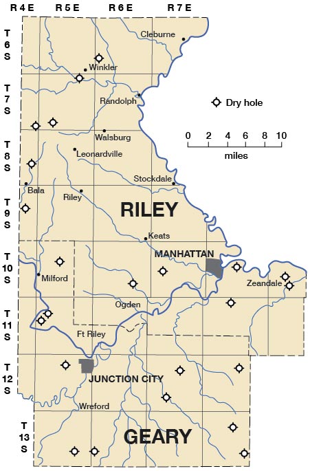
Oil and Gas Test Wells--Figure 2 shows the locations of the 23 wells drilled for oil and gas in the two counties. Large areas are still untested and only 7 of the wells thus far drilled constitute adequate tests of the possible producing rocks in their vicinity, in this area of more than 1,000 square miles. Tables 5 and 6 list the wells that have been drilled in Riley and Geary counties. [These tables have been replaced. Please use our database query to find wells in these counties]. Nine wells were drilled into pre-Paleozoic rock, but in two of these, rocks of the Lansing group lie upon the granite. Hence these two wells, Cain Bloom No. 1 and No. 2 Zeandale, tested only Lansing and younger rocks. Three wells were abandoned before reaching the base of the Pennsylvanian rocks. One of these reached only as deep as the Douglas group. Two wells were stopped in the Mississippian limestone and eight in either the Hunton or Maquoketa formations, leaving untested the Viola, Simpson, and Arbuckle formations, all three of which are important producing zones elsewhere in Kansas.
Figure 2.--Map of Riley and Geary counties showing locations of wells drilled to test for oil and gas.
Commercial accumulations of oil and gas are generally found in more or less minute openings in rocks buried below the surface. "Oil sands" are, as a rule, porous rocks, but not all are sandstones. Because oil and gas are lighter than water they will rise to the surface of any body of water, and because gas is lighter than air it will escape into the atmosphere if free to do so. As water fills almost all rock openings, it is necessary that something prevent the upward movement of oil and gas if they are to accumulate in natural reservoirs. It is believed that oil and gas, if present, migrate upward through the ground water in a dipping bed of porous rock until stopped by some obstruction. Hence, if a bed of sandstone containing water, oil, and gas underlies a bed of impervious shale and is arched into a dome or anticline, the gas will accumulate below the impervious shale at the crest of the upfold, the oil will collect a little farther down, and the water will remain in the lower parts of the sandstone. The petroleum geologist therefore seeks anticlines and domes in his quest for new fields. Several, perhaps nearly all, of the wells, in Riley and Geary counties were drilled on surface anticlines, but it should be noted that in some cases the crest of an anticline as it appears at the surface does not lie directly above the crest in deeper rocks.
There are, however, several other types of structural features that are favorable for the accumulation of oil and gas. When sedimentary formations are uplifted and subjected to erosion and on these warped and eroded beds is deposited another succession of strata, the overlying rocks are said to be unconformable with respect to the underlying beds. When beds are more or less sharply upturned below an unconformity and are sealed by overlying rocks, the resulting structure may constitute a "stratigraphic trap" for oil or gas. Impervious layers above obstruct the upward migration of gas and oil in the beds below the unconformity. In fact, some of the largest oil fields of the world are the result of accumulation below unconformities or along the unconformable contacts.
On both sides of the Nemaha Mountains pre-Pennsylvanian rocks are believed to be in positions that might have formed stratigraphic traps. All such structures along the cast side of the buried mountains probably lie east of Riley and Geary counties, but it may be said that there is a possibility--even a probability--that oil will be found in these counties in this type of structure west of the Nemaha Mountains. It is especially noteworthy that a small amount of oil was produced from the upper part of the Mississippian limestone in the Roth and Faurot No. 1 Brandbury well in sec. 21, T. 9 S., R. 4 E., Clay County, almost on the Geary County line. Shows of oil were reported from several other formations in wells in both Riley and Geary counties.
The two counties should not be regarded as proved barren of oil and gas. Large areas are untested and most of the deeper rocks are almost untested. It is not certain that all surface anticlines have been drilled or have been drilled in the most favorable locations. Because of the several unconformities and attitude of the rocks in the stratigraphic succession there may be favorable structures that cannot be detected from surface investigations.
Sand and Gravel
There are large quantities of river-deposited sand in the stream beds and below the surface of the valley fillings of the major streams. As stated in another section of this report, the thickness of these alluvial deposits in the valleys of the larger streams, Kansas, Big Blue, Smoky Hill, and Republican rivers, is at least 50 feet. The material constituting the fills in the valleys of the smaller streams is more generally silt. In the valley fillings of the larger streams one generally finds the coarser sand and gravel near the base of the deposit, and the silt and fine sand near the top. In the river beds there are great quantities of sand and gravel almost free from silt. These river sands are well adapted to many commercial uses but are not adapted to special uses for which an almost pure quartz sand is required. The sands and gravels are composed of fragments of quartz, feldspar, and other resistant minerals. Inasmuch as river sands are constantly replaced, the supply is virtually inexhaustible. Ray Whitla, of the Kansas Geological Survey, is investigating the glass and molding sand resources of Kansas. According to Whitla (personal communication) small amounts of molding sand from Riley County are being marketed.
Water Resources
The principal cities obtain water from the alluvium in the valleys of the major streams. The alluvial fillings of the valleys of Kansas, Big Blue, Smoky Hill, and Republican rivers hold a supply of water that is ample for almost any ordinary industrial purpose. In the fillings of smaller stream valleys are smaller amounts of water. The valleys of minor streams are filled principally with silt and redeposited loess, which are almost impervious, and hence there may be no water available below the smaller floodplains. Repeated testings in small-valley fillings in many parts of eastern Kansas have shown, however, that excellent water supplies can be obtained from very small alluvial fills, so in seasons of extreme drought the investigation of the fillings of small, even intermittent, streams should not be neglected.
The depth at which water is found in areas remote from the stream valleys depends upon the geologic formations and their structural condition and relationship to the topography. In ordinary seasons water for farm and domestic use is found almost everywhere at a comparatively shallow depth. The Cottonwood limestone and the Fort Riley limestone are the chief aquifers. Numerous springs issue from ledges of these two limestones, and in many places where these two strata are high on hillsides it is possible to obtain a large supply of water under pressure at farm plants near the foot of the hills. This is especially true along westward-facing hillsides, as in general the strata dip to the west.
Many persons interested in obtaining water are not aware of the important bearing of stratigraphic geology on the occurrence of ground water. To the careful observer this importance becomes very patent in seasons of extreme drought such as occur all too often in eastern Kansas. Water can be obtained only from rocks that contain openings large enough to allow the water to emerge when a well penetrates the rock. Although a bed of clay or shale may contain a great volume of water held in microscopic interstices between the clay particles, the water will not move readily through these minute spaces, and hence the material is said to be relatively impermeable. Other rocks may be so compact that there is room for very little if any water between particles of solid material. The foregoing descriptions of rock layers in Riley and Geary counties show that the individual strata vary widely, and as it is extremely important that the well digger know the rock layer that he expects to reach, maps showing areal geology have practical usefulness.
Moore (1940) has recently contributed a general discussion of the ground-water resources of Kansas, a report that should be of interest to almost all citizens of the state. The State Geological Survey in cooperation with the Federal Geological Survey began a systematic program of ground-water investigations in 1937. Extensive and detailed studies have been made in several parts of Kansas and it is planned to extend the ground-water survey to various other parts of eastern and western Kansas. These studies are being made by a staff of geologists and engineers specially trained in hydrology and are under the supervision of S. W. Lohman of the Federal Geological Survey.
Water in shale--About two-thirds of the rock that is close enough to the surface in the two counties to be reached by ordinary dug wells is shale and hence is not, in general, a good aquifer, but in areas where shale lies below the soil over a wide expanse, as in the places where shales like the Holmesville and Gage formations occur, there are fair supplies of water at shallow depth. This condition obtains because the shale is somewhat weathered and water moves along bedding and joint planes. Wells situated in such areas may be prolific if located down dip from an extensive catchment area. Shales that are topographically low and exposed only in narrow belts in valleys or along hillsides are generally very poor aquifers, because they have neither a large catchment basin nor open texture such as results from prolonged weathering. Water is commonly encountered at the top of shale layers where they are overlain directly by limestone, the water having migrated laterally and downward in scattered solution channels in the limestone and having spread laterally at the plane of contact between the limestone and the virtually impermeable shale bed below.
Water in limestone--As a rule the several limestone layers in the part of Kansas considered in this report carry water. Limestone if unbroken and unweathered is virtually impermeable, but, as it is slightly soluble in ground water, solution channels develop along bedding and joint planes when the rock has been in contact with water for some time. Hence, like the shales, in the plateau-like uplands where limestone lies just below the surface soil mantle it can be expected to carry large quantities of water. The city of Riley, in western Riley County, which lies at about the horizon of the Winfield limestone, obtains its water from a well that penetrates the Barneston limestone at a depth of 128 feet. The well produces 25 to 45 gallons of water a minute through a 10-inch drill hole. Leonardville, in the western part of Riley County, obtains water for the municipal system from two wells, drilled into the Barneston limestone at depths of 157 and 160 feet. The surface formation is the Nolans formation and overlying shale. One of these wells produces as much as 89 gallons a minute. The two wells are said to have produced 23,874,800 gallons of water in one year. These city wells give evidence of the large supply of fresh water obtainable from limestone beds below extensive dip slopes, and the importance of this supply was noted by Haworth (1913, pp. 87-89), when he cited the many farm wells near Leonardville and in similar geological surroundings near Winfield, Cowley County, Kansas. In Riley and Geary counties, the Cottonwood limestone, Fort Riley limestone, and Florence limestone are the most important water-bearing limestones. Locally other limestone beds are aquifers.
Water in sandstone--Farther east and west in Kansas massive sandstones lying near the surface are excellent aquifers, but there is virtually no sandstone among the rocks that lie within the zone of fresh ground water in these two counties. Those sandstone layers that can be reached by drilling are so deeply buried that their water is strongly mineralized and unfit for ordinary use. In the very small area in northwestern Riley County where the Dakota sandstone is present it probably contains some water, and it is very probable that the lenticular Indian Cave sandstone member in the basal part of the Towle shale formation at the base of the Permian system in southeastern Riley County is locally a good aquifer.
Surface water--As indicated on foregoing pages of this report, the two counties are well watered by the various major streams and their tributaries. As in other parts of Kansas, the retention and utilization of the water that enters the region in the streams and that falls as rain are jointly engineering and geological problems. There are many dry water courses that can be dammed and used as farm ponds. In that kind of project geology is an important factor, because the ability of the pond to hold water depends upon the nature of the underlying rock. Properly constructed earth dams in sites selected by well-trained geologists provide excellent ponds, which can be expected to exist for many years and hence to be a source of permanent benefit to rural communities. Another type of dam that would augment the water supply during dry seasons is the low concrete or masonry dam built from bank to bank in the more nearly permanent streams that seldom become completely dry but cease to flow during dry seasons. Such dams should impound water only between the stream banks and not above tillable soil. Low dams of this kind require no spillways nor sluice gates. Attention is called to a recent publication, Dams on dry watercourses, of the Kansas State Board of Agriculture (Mohler, 1939) that contains the Kansas water-storage law and much helpful information on dam construction.
Prev Page--Structural Geology || Next Page--References
Kansas Geological Survey, Geology of Riley and Geary Counties
Web version Nov. 2000. Original publication date Dec. 1941.
Comments to webadmin@kgs.ku.edu
The URL for this page is http://www.kgs.ku.edu/General/Geology/Riley/economic.html