![]()
Prev Page--Cretaceous System || Next Page--Structural Geology
Igneous Rock
In three places in Riley County igneous rock, obviously intruded from below, is exposed at the surface: in sec. 6, T. 9 S., R. 5 E., in sec. 23, T. S S., R. 6 E., and in sec. 22, T. 8 S., R,. 5 E. All three of these bodies are similar, and consist of dark-green fine-grained ground-mass of igneous rock containing many fragments of the neighboring sedimentary rock.
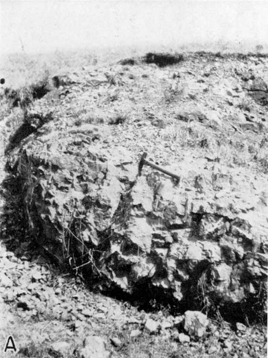
The exposure in sec. 6, T. 9 S., R. 5 E., is situated near the northwest corner of the section, between a railroad and highway, and about 1 mile east of Bala. This exposure is frequently called the Riley County igneous exposure, but inasmuch as there are at least two other bodies of igneous rock exposed at the surface in Riley County it should be called the Bala igneous exposure. The rock was described by Moore and Hayness (1920, pp. 183-187) and they gave credit for its discovery to T. S. Harrison of Denver, Colo. The rock is an igneous breccia or aglomerate comprising a ground-mass of basalt and inclusions consisting principally of shale in various stages of alteration. Fissures caused by jointing have become filled with calcite. The presence of the rock is expressed physiographically by a rounded knoll about 10 feet high and less than an acre in extent. The exposures are confined to small areas on the west and north sides of the hill. The age of the rock is probably Cretaceous. The contact with surrounding country rock is not exposed, but about 0.1 mile west of the, exposure the Stovall limestone member of the Winfield formation is sharply folded and about 0.25 mile west of the outcrop the members of the Winfield formation are cut by a small fault. Folding and faulting of minor magnitude are somewhat common in that area, however, and the condition is probably not due to igneous intrusion. Along the west side of sec. 33, T. 8 S., R. 6 E., about 8 miles east of the Bala exposure and about 5 miles southwest of the igneous body near Stockdale, the Winfield beds are strongly crumpled and faulted. The nature of the rocks underlying this area is not known as there are no entrenching streams nearby. It is probable that solution of some underlying beds has caused this condition, although it may be due to igneous, rock intrusion.
Plate 15A--A portion of a small hill, physiographic expression of an igneous intrusion, sec. 6, T. 9 S., R. 5 E., Riley County.
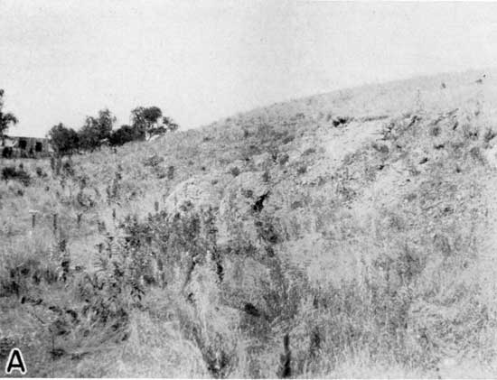
Plate 16A--An exposure of basic igneous rock, sec. 6, T. 9 S., R. 5 E., Riley County.
Another body of igneous rock is exposed in Riley County in sec. 23, T. 8 S., R. 6 E., about 5 miles northwest of Stockdale. It is about 0.25 mile west of the east end of the east-west line that bisects the section. The exposure was discovered several years ago Professor H. Faliyer of Manhattan. The igneous mass is exposed in a stream bed in an area about 50 by 150 feet, and seems to be only slightly more resistant to erosion than is the surrounding Holmesville shale. The contact with surrounding sedimentary rock is not exposed, so it is not definitely known that the igneous body is intrusive rather, than a surface flow. Its position in the stream, however, indicates that it is not a flow on the present topographic surface. The rock is exposed in a small stream that is cutting the Holmesville shale. The Towanda limestone caps the hills on each side of the stream and about 20 feet above it. The rock is an igneous breccia or an agglomerate; a ground mass of dark-green material contains a great many inclusions of sedimentary rock in various stages of alteration, and shale, flint, and limestone can be recognized in hand specimens. Numerous crystals of wine-colored garnet are present, but they are small and are badly shattered. Some joints are filled with calcite. The rock is weathering rapidly into small fragments. One fragment of granular igneous rock composed principally of quartz, but containing a minor amount of ferromagnesian minerals, was found at the outcrop. This suggests that possibly two generations of igneous rock are present there.
A third body of igneous rock similar to the two just described has been found in sec. 22, T. 8 S., R. 5 E.
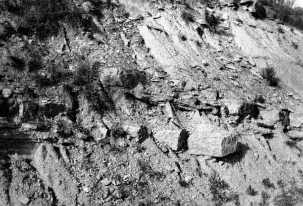
The igneous rock is shown on the geologic map (pl. 1). Plates 15A and 16A show views of the Bala igneous exposure. Plate 17 shows the faulted Winfield limestone beds near the Bala igneous exposure.
Plate 17--Faulted Winfield beds, sec. 1, T. 9 S., R. 4 E., Riley County. The Stovall limestone is overthrust toward the west.
Prev Page--Cretaceous System || Next Page--Structural Geology
Kansas Geological Survey, Geology of Riley and Geary Counties
Web version Nov. 2000. Original publication date Dec. 1941.
Comments to webadmin@kgs.ku.edu
The URL for this page is http://www.kgs.ku.edu/General/Geology/Riley/igneous.html