![]()
Prev Page--Introduction || Next Page--Stratigraphy
Geography
Location and Area
Riley and Geary counties are situated in northeastern Kansas in the fifth tier of counties west of Missouri river. Riley County is in the second tier of counties south of the Nebraska-Kansas border, and Geary County adjoins Riley County on the south. The eastern boundary of the area is approximately 100 miles west of the Missouri-Kansas state line and the northern border is 30 miles south of the Nebraska-Kansas state line. Riley County is bounded on the north by Washington and Marshall counties, on the east by Pottawatomie county, on the south by Wabaunsee and Geary counties, and on the west by Geary and Clay counties. It is irregular in shape, but is roughly a truncated triangle having an area of 617 square miles. The north-south dimension is 36 miles and the greatest east-west dimension is 25 miles. The county comprises townships 6 to 11 south in ranges 4 to 9 east. Geary County is bounded on the north by Riley County, on the east by Riley and Wabaunsee counties, on the south by Wabaunsee and Morris counties, and on the west by Dickinson and Clay counties. The area of Geary County is 407 square miles. The greatest north-south dimension is 24 miles, and the greatest east-west dimension is 25 miles. Geary County comprises townships or parts of townships 10 to 13 south in ranges 4 to 8 east. The area covered by this report is bounded approximately by parallels 38° 50' and 39° 40' N. latitude and by meridians 96° 30' and 97° W. longitude. Frequently, but erroneously, the geographic center of the United States is said to lie within the Fort Riley Military Reservation and approximately at the center of the area discussed. Judicially part of the military reservation is in each county. According to information given by the Federal Board of Surveys and Maps (Circular 33484, July, 1929) the geographic center of the United States is in Smith county, Kansas, not far from the village of Lebanon. The point is in latitude 39° 50', longitude 98° 35'.
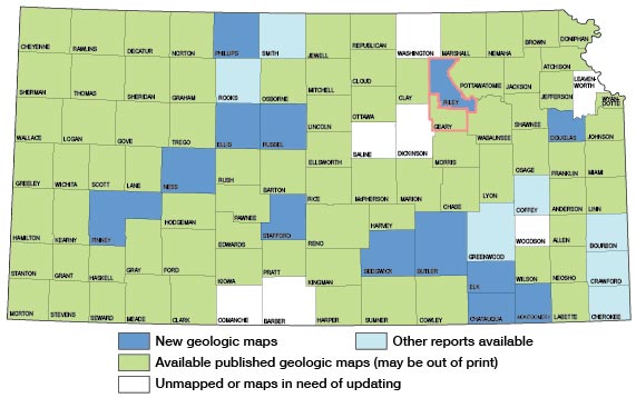
Figure 1.--Index map of Kansas showing area described in this report and areas covered by other geologic maps, as of Jan 1999. For additional information, the KGS Geologic Maps of Kansas Page.
History
Eighty-three counties, including Riley and Davis, were organized in 1855. The present Geary County was called Davis until 1889, having been named in honor of Jefferson Davis, who was Secretary of War when the counties were organized. The present irregular shape of the counties is the result of several changes in the boundaries.
Before the white settlers came, Indians occupied the river valleys, and remains of their villages can still be found. The present Junction City, county seat of Geary County, was the site of a village of the Kaw tribe as late as 1856. It is probable that Coronado was the first white man to visit the area of the two counties, as he is generally believed to have found Quivira some place in this vicinity in 1642. In 1843 John Fremont traveled through this part of Kansas. The first white settler in the area that is now Riley County was Samuel Dyer, who operated a ferry on Big Blue river at Juniata, which is a few miles north of the river's mouth. Several historic roads crossed this part of Kansas. The Leavenworth and Pike's Peak Express passed through Fort Riley, and the fort was a station on the Butterfield Overland Dispatch Route. The south branch of the California Trail passed through Manhattan.
Fort Riley, first called Camp Center, was established in 1852 on a site selected by Major E. A. Ogden, in whose honor the town of Ogden was named. In 1853 the name of the army post was changed to Fort Riley in honor of General Riley, who fought in the war with Mexico and who commanded scouts along the Santa Fe trail. Fort Riley is now one of the nation's large army posts, is the home of the Cavalry School, and is the largest cavalry post in the United States. During World War I, Camp Funston was located on the army reservation east of the post. It was the 14th National Army encampment, and the 7th, 10th, and 89th Divisions were trained there. Camp Whitside and Marshall Flying Field also are on the reservation, which comprises 22,000 acres.
Manhattan, situated at the confluence of Kansas and Big Blue rivers, is the outgrowth of two towns, Poleska and Canton, which were united in 1855 to form "Boston." Later in the year, 75 people arrived from Cincinnati on the steamship Hartford. They had come to Kansas intending to found a town called Manhattan and had brought with them on the boat ten houses ready to erect. The people of Boston gave them half the townsite and the privilege of changing the name to Manhattan. At first Ogden was the county seat of Riley County, but later Manhattan became the county seat.
The valleys of the larger streams and of smaller ones such as Fancy creek and Deep creek were settled early. Settlers came to Deep creek valley in 1845. The town of Zeandale, the name of which means corn valley, was established in 1854 and a Congregational church was established there in the same year. A. W. Tabor, who later became famous as a discoverer of gold at Leadville, as one of the builders of Denver, and as U. S. Senator from Colorado, came to the eastern part of Deep creek valley in 1856 and started farming. Tabor Valley school in see. 8, T. 11 S., R. 9 E., has been named for him and is near the farm he established. The name of Pillsbury Crossing, which is a beautiful natural ford over Deep creek south of Zeandale, commemorates the founder of Zeandale. In the years after the Civil War many settlers came to northern Riley County from northern Europe. In 1886 the town of Cleburne was founded after the neighboring valleys had been settled by Swedes who came directly from Sweden to establish homes. The descendants of these settlers now own many of the fertile farms there. The several beautiful rural churches in northeastern Riley County bear evidence of their substantiality.
Junction City, which is now the county seat of Geary County, was founded in 1855. It is situated at the junction of Smoky Hill and Kansas rivers. It became the county seat in 1860. The first county seat was Ashland, now a landmark in southern Riley County. Pawnee was established in 1854; its site is between Fort Riley and old Camp Funston on the military reservation. The first legislature of Kansas Territory met there in 1855. The building that served as the first territorial capitol is still standing and was restored to its original condition a few years ago.
Population
According to the 1940 government census, the population of Riley County is 20,617 [62,852 in 2000; Kansas Statistical Abstract 2009, KU Institute for Policy & Social Research, September 2010]; of Manhattan, 11,659 [44,831 in 2000]; of Geary County, 15,222 [27,947 in 2000]; and of Junction City, 8,507 [18,886 in 2000].
Cities and Towns
The largest city in the area is Manhattan. It is situated on the main lines of Chicago, Rock Island, and Pacific and Union Pacific railways, and is the south terminus of the Manhattan and Blue Valley branch of the Union Pacific. Randolph, Cleburne, and Stockdale are towns on the west side of Big Blue river and on Manhattan and Blue Valley railway. Zeandale, in eastern Riley County, Keats in the central part, and Riley and Bala in the western part, are situated on Chicago, Rock Island, and Pacific railway. Leonardville is 5 miles north of Riley. The villages of Walsburg, Lasita, Winkler, Bodaville, and May Day in the northern part of the county are not on railways.
Junction City is the largest city in Geary County and is the county seat. It is situated on the main line of Union Pacific railway and is the terminus of a branch from Belleville. It is the terminus of a Missouri, Kansas and Texas branch line from Parsons, Kan. Milford and Alida are small towns on Republican river on the Belleville branch railway. Wreford is a small town south of Junction City on Missouri, Kansas and Texas railway.
Industries
The chief industries of the two counties are agriculture and the industries related to agriculture-general farming, stock feeding and breeding, poultry breeding, and some truck growing. There is a direct relationship between the type of agricultural products and the type of topography within the area. In the river valleys corn, wheat, alfalfa, kafir corn, sorghum, and some fruit are produced. A small amount of truck is grown in Kansas river valley near Zeandale, Manhattan, Ogden, and Junction City. Some cattle and hogs are raised in the creek and river valleys, but large numbers of cattle are pastured on the rough uplands. On the high rolling land, which is generally the dip slope of Fort Riley limestone, corn, wheat, alfalfa, oats, kafir corn, sorghum, and prairie hay are produced and cattle and hogs are fed for market. Urban industries are primarily related to agriculture and general merchandising. Kansas State College of Agriculture and Applied Sciences is situated at Manhattan. The proximity of the army post to Junction City tends to direct activities along lines unusual in most Kansas towns.
The railroads offer adequate shipping facilities throughout the area, but the motor truck has almost superseded the railroad in the hauling of local freight. United States highways 40 and 24 pass through Manhattan. United States highway 77 (Canada to Dallas) passes through the area by way of Junction City. Most of the roads are graveled or hard-surfaced. Others are kept in good repair, and all parts of the area are accessible by automobile. Most of the towns are served by motor stage routes. Manhattan has an airport, and the military flying field at Fort Riley is excellent.
Climate
The area is part of a region in which the climate is marked by extremes of precipitation and temperature. Weather Bureau records show that the annual precipitation at Manhattan has ranged between 17 and 47 inches and that the temperature has ranged from -32° to 115° F. The table (Carter and Smith, 1908, p. 9) below shows the normal monthly and annual temperature and precipitation.
Table 1--Normal monthly and annual temperature and precipitation at Manhattan, Kansas
| Month | Temp (°F) | Precip. (inches) |
|---|---|---|
| January | 31.0 | 0.75 |
| February | 26.6 | 1.13 |
| March | 42.6 | 1.35 |
| April | 55.3 | 2.73 |
| May | 66.8 | 4.32 |
| June | 74.7 | 4.42 |
| July | 79.5 | 4.67 |
| August | 79.2 | 3.58 |
| September | 69.0 | 3.04 |
| October | 61.1 | 2.24 |
| November | 44.1 | 1.28 |
| December | 31.2 | 0.85 |
| Year | 30.36 |
The amount of rainfall varies greatly from year to year and occasional droughts are experienced. The summers of 1930, 1934, and 1936 were extremely dry, and farm crops suffered serious damage. The average growing season (from last to first killing frost) extends from April 20 to October 9 (Carter and Smith, 1908, p. 10).
Topography
Riley and Geary counties lie within the physiographic province generally called the Central Lowlands, an area bordered by the High Plains on the west and by the Ozark and Appalachian plateaus on the east. This great area, like other natural physiographic units of the United States, has been divided by geographers into sections (Fenneman, 1938). Almost the entire area of the counties treated in this report lies within the section called Osage. A small part of northern and eastern Riley County lies within the limits of the Dissected Till Plains. In general the Osage Plains are best described as "scarped plains," an area in which strata dipping gently to the north of west have been beveled by an erosional plain sloping eastward, and in which the resistant rock layers form eastward or southeastward facing escarpments. Streams are incised below the old plain and the topography is semirugged.
This area is part of an older erosional plain that is now being dissected, and maturity has been reached in the present erosional cycle. The erosional history of eastern Kansas is probably very complex and certainly has not yet been satisfactorily deciphered. The crests of the escarpments, which are the physiographic expression of resistant rock layers, lie very nearly in a plane, which slopes gently downward from the eastern border of the Cretaceous sediments eastward to the western boundary of the Ozark plateau. Fenneman (1938, p. 660) indicates that this is probably the westward extension of the Ozark peneplain, which was supposedly completed late in Tertiary time. The overlap of Cretaceous sediments on the beveled Permian strata of Kansas and on older rocks to the north and east indicate that the pre-Cretaceous erosional plain in eastern Kansas may also have been very near this level. In another part of this report it is shown that Dakota sandstone has only recently been eroded from the tops of cuestas in Geary County where it formerly lay not far above the Fort Riley limestone, and that similar Cretaceous rock is still present not far above the Herington limestone in northwestern Riley County. The widespread distribution of Tertiary sediments in the same plane is indicated by the deposits of flint gravels, locally several tens of feet in thickness, capping the cuestas from the Flint Hills to the Ozark plateau. Both Arkansas and Kansas rivers are obsequent to rock structure across central and eastern Kansas and thus have the characters of streams that were superposed upon a plain of deposition. It has been my observation that Marais des Cygnes river has inclosed meanders in eastern Kansas as it has in Missouri (Osage river of Missouri) (Winslow, 1893, pp. 31-32). Flint gravel, very probably of Tertiary age, is still present on the uplands near the inclosed meanders in Linn county, Kansas, and similar gravel is still very widespread on uplands on each side of Kansas river.
The relief of Riley and Geary counties is between 450 and 500 feet. The lowest point is the surface of the water of Kansas river east of Zeandale, on the eastern border of Riley County, normally approximately 1,000 feet above sea level. The highest point, near the southeast corner of Riley County, has an altitude of approximately 1,450 feet.
The topography can very well be divided into three minor types: the high uplands or prairies, which are the cuesta uplands or the "dip-slopes" of resistant limestone layers and for which the term "high" is used in a relative sense; the creek and rivers valleys, including the alluvial floors and terraces; and the broken, billy country extending from the borders of the uplands downward to the valley floors or to the terraces where present. This last division includes the escarpments, and it includes the Flint Hills, which are discussed separately.
The high prairies of the first division generally lie at an altitude of 1,250 to 1,450 feet above sea level and are above the Fort Riley limestone although small areas below that stratum of rock have similar aspects. Although the uplands are described as dip slopes of the limestone strata, they are almost everywhere covered with a part of the shale unit overlying the scarp-making limestone. Streams cutting into the thick shale above the Fort Riley limestone have carved most of this area into a rolling plateau. In eastern and northern Riley County the Cresswell and Herington limestones and to a minor degree the Towanda limestone, resistant strata above the Fort Riley limestone, form small buttes and sinuous escarpments. The eastern boundary of these uplands is extremely irregular because many streams have cut into and below the Fort Riley limestone. In southern Geary County the uplands are cut into great finger-like strips pointing toward Smoky Hill river and away from the greater expanse of similar terrain.
The larger stream valleys are those of Kansas, Big Blue, Republican, and Smoky Hill rivers. River valleys range from 1 to 4 miles in width and creek valleys from 0.25 to 0.5 mile or more. River valleys are almost level and are modified by swamps and by a few ox-bow or crescentic lakes. Eureka Lake, a few miles west of Manhattan, and Whisky Lake, south of Fort Riley, are the largest, and lie in Kansas river valley. The flat "bottom land" of the smaller streams is being built up more rapidly by downwash from the valley walls than by deposition by the streams themselves, hence they are principally colluvial and the streams themselves are cutting into bed rock but these areas are subjected to occasional floods during which alluvium is deposited. Creek valleys are somewhat elevated above the creek beds and generally are somewhat rolling. Although the colluvial and alluvial soil of the small stream valleys conceals the rock strata at the sides of the valley, the resistant layers can generally be seen in the stream beds. In many places the streams are actively widening their valleys and evidence of landslides of considerable magnitude is visible, especially along the right valley walls. At Rocky Ford, north of Manhattan, bed rock is exposed in the channel of Big Blue river, but there the stream is now flowing near its right valley wall and is only locally and temporarily degrading the limestone beds. There is no doubt that soundings on the east side and remote from the river would show that the bed rock is lower there than in the present channel. River channels have shifted actively, even very recently, and pronounced changes have taken place since the area was settled. The channel of Big Blue river has shifted eastward a mile or more at Manhattan since the city was founded and an old mill formerly at a dam on Fancy creek in northern Riley County is now separated from the creek by a wide field.
Valley walls are steep, rugged bluffs 50 to 200 feet high, except locally, as near Zeandale, Manhattan, and Ogden, where the valley of Kansas river is bordered by rolling uplands--a modification of the prevalent type of valley-wall topography due to the presence of deposits of loess. In many places remnants of a former fluvial, or possibly lacustrine filling, now form a distinctive terrace along the sides of the valleys above the present flood plain of the larger streams. Such terraces are noticeable along the west bluff of the valley of Big Blue river a few miles north of Manhattan, and south of Kansas river east of Manhattan. These terraces have yielded mammalian fossils of Pleistocene age. Detailed investigation will probably show that the terraces of the large stream valleys are equivalent to much of the "bottom land" of the small valleys.
The third type of topography is represented between the stream valleys and the high uplands. It is limited generally by the outcrop of Fort Riley limestone, which forms a fence-like wall near the crests of the hills along the eastward extension of its line of outcrop, and farther west, in the direction of the regional dip, forms exposures near the streams. With the exception of stream valleys and other minor areas, the hilly land lies east of the Fort Riley limestone outcrop. Below the Fort Riley limestone is the Florence limestone-a thick layer containing an abundance of flint nodules. It is eroded into rounded hills that are cast of the great, flat-topped area capped by Fort Riley limestone. As soon as the weathering disintegrates the protective upper limestone, the less resistant flint bearing rock is rapidly eroded. Strata below the Fort Riley limestone weather to steeply terraced slopes, and it is principally these strata that form the slopes of the Flint Hills in this part of Kansas. The hills capped by Fort Riley limestone and the knobs capped by Florence limestone, however, are a part of the general Flint Hills region.
The northeastern part of Riley County lies within the part of the Central Lowlands known as the Dissected Till Plains. Glacial drift is not thick within the limits of the county, but northern erratics ranging from gravel to large boulders are present.
The Flint Hills
The Flint Hills are a range of hills that has a relief of about 350 feet and crosses the state in an almost north-south direction from Marshall county in the north to Cowley county in the south. This range is one of several eastward facing dissected escarpments that mark the topography of Kansas. In the western central part of the state are the Blue Hills, marking the eastward limit of the Tertiary-mantled High Plains. In the central part are the Smoky Hills, the dissected escarpment of the Dakota sandstones of Cretaceous age. Those two escarpments bound the physiographic sub-province called the Plain's Border. The Flint Hills are due to the presence of resistant Permian strata and are therefore physiographically like the other ranges named. Farther east is another range trending east to north from about the boundary between Montgomery and Chautauqua counties, which is near the 96th meridian, toward Leavenworth on Missouri river, but becoming less conspicuous to the northward. This ridge is capped by the thick sandstones in the Stranger and Lawrence formations of the Pennsylvanian subsystem. In southern Kansas these hills are called Chautauqua Hills (Adams, 1899, p. 60) and the name may well be applied to the whole range.
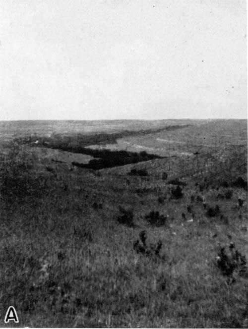
Plate 3A--Flint Hills topography. A valey eroded in Big Blue strata; Cottonwood and Eiss limestone on the hillside in right background, southeastern Riley County.
The escarpments in the Pennsylvanian and Permian areas are capped by westward-dipping resistant strata that are separated by less-resistant beds. Their direction, of course, follows the strike of the beds; their spacing and height are governed by the vertical distance between beds that are strong enough to hold extensive benches or plateaus, and by the inclination of the beds. The height of the Flint Hills, therefore, is due to the presence of a few hundred feet of soft strata beneath a few beds that will hold benches under the conditions of weathering to which they are subjected. In the northern half of the state seemingly it is not flint bearing limestones that are responsible the hills, but rather it seems to be the absence of flint in certain limestones. In Riley and Geary counties the non-flinty Fort Riley limestone, the non-flinty part of the Three mile limestone, a bed in the Wreford limestone formation containing no flint, and lower beds, such as the Eiss limestone in the Bader formation, make extensive benches. In the same part of the state the flinty layers are readily weathered into steep slopes and rounded knobs. The Florence limestone is about 35 feet thick and contains an abundance of flint nodules. Above the Florence and separated from it only by a few feet of shale is the Fort Riley limestone, which contains no flint. The Fort Riley limestone holds up benches over hundreds of square miles, but wherever the protective Fort Riley is removed the flinty Florence is reduced to rounded buttes. the same relationship between flinty and non-flinty beds is true in the area of outcrop of the Wreford formation, but not, however, in the southern part of the state, where the Florence member makes hills for many miles. This difference may be due to a very slight difference in climate, but it seems more probable that in southern Kansas a protective covering of Tertiary(?) age protected for a longer time the areas where the Florence is now exposed and hence preserved them. this explanation is supported by the presence of erratic pebbles of presumably Rocky Mountain derivation as far east as sec. 33, T. 27S, R. 2 E, in Sedgwick county, and by the presence of deep deposits of flint gravel on the uplands of much of eastern Kansas. The significance of these gravels in the physiographic history of eastern Kansas has already been discussed in this report.
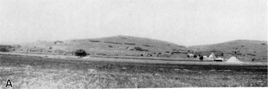
Plate 4A--Flint Hills topography. South wall of Kansas river valley, southeast of Manhattan in Riley County. The Falls City limestone forms the point on the skyline near the extreme left.
Bass (1929, p. 14) indicated that different formations comprise the upland surfaces of the Flint Hills in different areas. In central Kansas the Florence flint (limestone containing flint nodules) is the capping rock; farther south the Wreford, about 60 feet below the Florence, and still farther south the Foraker, 300 feet below the Wreford. form the principal rim and upland of the Flint Hills. It should not be assumed that the Flint Hills are developed in lower and lower strata as one goes southward, however, for, although it is true that in Riley County the Fort Riley limestone is the great bench-maker above and west of the dissected escarpment, the belt of hills is nearly 20 miles wide and in the eastern part the steep slopes expose formations from the Tarkio limestone (Wabaunsee group, Pennsylvanian subsystem) to the Americus (Foraker formation) or neighboring strata. Steep slopes downward from higher strata, such as the Fort Riley, are observed near places where major streams cut the escarpment. In such places as the valley of Kansas river the escarpment has been rapidly driven westward so that the steep slopes extend from higher strata to the valley floor. Farther from the rivers the escarpment is older and is more obtusely beveled.
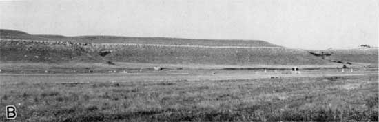
Plate 4b--Flint Hills topography. Fort Riley limestone forming a natural wall near the top of the north walll of Republican river valley, Fort Riley Military Reservation.
The Flint Hills are nearly coincidental in position with the gentle arch of strata above a buried range of low mountains called the Nemaha Mountains (Moore and Haynes, 1917, p. 166), and a small part of the ruggedness of the hills is due to that arching. Relief within the Flint Hills is generally less than 350 feet. The slopes are steep and terraced. As the hills are grass-covered and only slightly forested, the belt is a rich grazing area. It exhibits perhaps the most beautiful natural scenery of the state.
Drainage
A small part of southeastern Riley County is drained by Neosho river, a tributary to Arkansas river. The rest of the area is drained by Kansas river and its, tributaries. Kansas river is formed by the confluence if the Smoky Hill and Republican rivers at Junction City in Geary County. An important tributary from the north, Big Blue river, empties into Kansas river at Manhattan. An intricate system of streams drains the area. The larger streams are included on the map showing areal geology. The larger streams are mostly near grade and their flood plains are well developed. The smaller streams have predominantly low gradient where they flow on strata above Fort Riley limestone, but are generally more turbulent and occupy narrower canyons where they cut through lower strata.
Smoky Hill river rises in eastern Colorado in Kit Carson and Cheyenne counties. It flows eastward across Kansas to a point near McPherson, thence northward to Salina, and then northwestward across Dickinson County into Geary County. At Junction City it unites with Republican river to form Kansas river. Smoky Hill river is 310 miles long and drains 20,480 square miles. It rises in an area of sand, clay, and gravel of Tertiary age and flows through the Cretaceous chalk, limestone, shale, and sandstone, and the Permian shale, limestone, and gypsum. Republican river likewise has its headwaters far east of the Rocky Mountains. It rises in northeastern Colorado and drains 25,840 square miles. Its length is about 500 miles. It flows across Tertiary deposits throughout most of its course. Kansas river flows from Junction City to Kansas City, where it enters Missouri river.
Prev Page--Introduction || Next Page--Stratigraphy
Kansas Geological Survey, Geology of Riley and Geary Counties
Web version Nov. 2000. Original publication date Dec. 1941.
Comments to webadmin@kgs.ku.edu
The URL for this page is http://www.kgs.ku.edu/General/Geology/Riley/geog01.html