![]()
Prev Page--Geologic Structure || Next Page--Plates
Economic Resources
The mineral resources of economic importance in Cloud and Republic counties are gravel and sand, building stone, coal, clay, water and soil. Salt is of historic interest only, for the first salt produced in Kansas came from evaporating the natural brines of the salt marshes in this section.
Sand and Gravel
Sand and gravel have a low unit value and for economic reasons cannot be transported far from the pit where they are produced. Consequently these materials are generally mined by the consumer or purchased by him directly from the producer. It is necessary, therefore, to develop as many widely separated deposits as possible, even though some of the deposits may not be large. The gravel and sand deposits of Cloud and Republic counties vary considerably in age. They are grouped in this report according to source of material and discussed in the order of their importance. Each deposit is described, and possible places where new supplies may be found are indicated.
Group 1--River and flood-plain deposits
A. Republican River--Sand and gravel are produced from Republican river at Scandia, Republic County, and from the flood plain at Concordia, Cloud County. Whether the material comes from the present channel, an old channel, or the flood plain it is the same in quality and consists of a clean quartz sand and gravel of excellent strength. The following analyses will serve to show the size of the material.
| Analyses of sand from old and present channels of the Republican River near Concordia, Cloud County |
||
|---|---|---|
| Screen mesh |
Percentage retained on screen | |
| Old channel | Present channel | |
| 1/4-inch | 1.58 | 1.40 |
| 10-inch | 9.88 | 19.80 |
| 20-inch | 16.00 | 19.60 |
| 30-inch | 28.62 | 20.15 |
| 40-inch | 22.76 | 11.34 |
| 50-inch | 13.27 | 9.56 |
| 80-inch | 6.62 | 6.86 |
| 100-inch | 0.42 | 0.57 |
| 200-inch | 0.40 | 0.56 |
Plate XVII--Sand pump in pit near Republican river at Concordia, Cloud County.
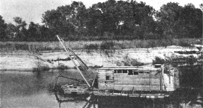
The flood plain and channel of Republican river constitute the largest single source of sand and gravel in Cloud and Republic counties. The supply is unlimited and of uniform quality along the entire sixty miles of the stream as it crosses the area. It can be produced cheaply by pumping, will wash and screen while wet, and is suitable for many purposes. The sand produced at Scandia is used for plastering, as fine aggregate in concrete, and in concrete blocks. The material produced at Concordia is used for road graveling after the finer material has been removed by screening.
B. Solomon River--Samples of sand and gravel taken from the bed of Solomon river near Glasco show that material of good quality may be produced from the channel of this stream at various places where it crosses the southwest corner of Cloud County. The material is coarser than that produced from the Republican river, due to the inclusion of fragments of local Cretaceous limestones. The finer material is composed primarily of quartz of excellent strength. The following analysis gives the size of material in a sample taken from a bar in the river near the southeast corner of sec. 8, T. 8 S., R. 5 W., west of Glasco.
| Screen analysis of sand and gravel from Solomon river |
|
|---|---|
| Screen mesh |
Percentage retained on screen |
| 1/4-inch | 25.81 |
| 10-inch | 26.21 |
| 20-inch | 18.05 |
| 30-inch | 10.82 |
| 40-inch | 9.16 |
| 50-inch | 6.02 |
| 80-inch | 2.74 |
| 100-inch | 0.25 |
| 200-inch | 0.30 |
Group 2--Pleistocene river gravels near Glasco
A. North of Solomon River--Extensive gravel and sand deposits occur in the Solomon river valley, both toward the northwest and southeast of Glasco. Some of the more important are as follows:
- 1. Chris Weaver, in the east center of the NW NW sec. 32, T. 7 S., R. 5 W.
- 2. Earl Sams, in the southwest corner of the SE sec. 30, T. 7 S., R. 5 W.
- 3. Dave Funk, in the southwest corner of the SE sec. 32, T. 7 S., R. 5 W.
- 4. Jim Hulse, in the SW sec. 33, T. 7 S., R. 5 W.
- 5. Geo. Downey, in the center of the NW NW sec. 4, T. 8 S., R. 5 W.
- 6. Geo. Davidson, 100 yards east of Downey pit.
Other pits occur southeast of Glasco and occupy a position in the Solomon valley similar to those listed.
The deposits are essentially the same from place to place and consist primarily of quartz sand and gravel with a small percentage of larger fragments composed of local Cretaceous limestone. A slight amount of clay is present and some of the deposits contain minor amounts of calcium carbonate cement. All are of good quality, however, and the material is suitable for many uses.
The following screen analysis of sand and gravel from the Weaver pit, in the northwest corner of sec. 32, T. 7 S., R. 5 W., northwest of Glasco, will serve to show the coarseness of the material.
| Approximate analysis of sand and gravel from the Weaver pit |
|
|---|---|
| Screen mesh |
Percentage retained on screen |
| 1/2-inch | 9 |
| 1/4-inch | 11 |
| 8-inch | 19 |
| 14-inch | 26 |
| 28-inch | 19 |
| 48-inch | 13 |
| 100-inch | 1 |
Gravel and sand from the deposits listed have been used locally in concrete and for graveling roads, after a part of the fine material has been removed by screening. With the abundance of water in the region it should be easily possible to wash the material, and by proper screening make it suitable not only for use as fine aggregate in concrete paving but for many other purposes, also.
The deposit appears to be extensive in the region of the pits and southeast of Glasco. By extending the old pits and opening up new pits an almost unlimited quantity of material could be made available.
B. South of the river--Two sand and gravel pits have been opened up in deposits of very similar material south of the river. One is on the Hugh Beck farm near the center of the west side of sec. 27, T. 8 S., R. 5 W., and the other on the Walter Butler farm near the center of the east side of sec. 2, T. 9 S., R. 5 W., directly south of Glasco. The material grades from fine sand to coarse gravel containing boulders up to a foot in diameter. Both the large and small sizes of gravel are composed of local limestone and sandstone. The Beck pit particularly contains a relatively large amount of gravel and will serve a good purpose by supplying local needs. It is hardly suitable, however, for extensive graveling projects or for concrete paving, due to its large content of soft material.
Group 3--Tertiary sand and gravel in Republic County
The basal portion of the Tertiary formation in Republic County consists in places of sand and gravel. It is of moderately good quality and is produced north of Belleville from a number of pits. The material consists of sand and gravel varying in size from very fine to pebbles 1/4 inch in diameter. It is composed primarily of quartz with a small percentage of pink feldspar. The upper part of the deposit exposed in the pit is slightly clayey, but the base is moderately clean. The depth of the deposit ranges from a few feet to 10 or 12 feet. The gravel and sand produced is used locally in graveling roads and for construction purposes. The pits open at the present time are adequate to take care of local trade, but there is a possibility that many new pits may be opened up along the edge of the formation.
Group 4--Sand dunes
Sand dunes are found at various places in the Republican river valley and along Otter creek in Republic County. A dune three miles northwest of Scandia has been mined for sand. Dune sand is uniformly fine-grained and is principally used in mortar and plaster.
Fence Posts, and Building Stone
"Fence Post" Bed--The "fence post" limestone has been quarried north and west of Glasco in Cloud County and at many places in Republic County. Quarrying is commonly done along the line of outcrop, where the overburden is thin and the rock not badly weathered. The bed varies in thickness from 6 to 9 inches and is moderately fine and chalky in texture. It is soft enough to permit considerable ease in quarrying, but hardens on exposure. It can always be identified at its outcrop or in a building or fence by its light creamy buff color, which grades into a darker buff band near the center.
The bed is quarried by uncovering the ledge for a distance of 6 or 8 feet from the outcrop, after which the rock is split into desired sizes by driving a row of wedges into it. For fence posts the rock is cut into strips about a foot wide and from 5 to 6 feet long. The wires are fastened to it by means of notches or drilled holes. Quarrying leaves a trench from 10 to 12 feet in width and 2 or 3 feet in depth in which water collects after a rain. Some of the older trenches are marked by a line of cottonwood trees which have grown as a result of the additional moisture. Other quarries may be traced by the narrow white ridge of waste material that is built up in uncovering the bed. Thousands of fence posts have been used in the area of the outcrop, not only in Cloud and Republic counties but in counties farther south and west. The rock has been used also in bridges and buildings, especially churches and schools. It is attractive when used in this way, particularly when rough trimmed.
Jetmore Limestone Member--Beds of the Jetmore limestone, particularly the "shell rock," have been quarried extensively in Cloud and to a lesser extent in Republic County. The more desirable "fence post" limestone bed is not widely exposed in Cloud County, so beds in the Jetmore are quarried instead. As with the "fence post" limestone, quarrying is confined to the brow of the hill or on the slopes where the limestone is covered to a depth of only two or three feet and is not badly weathered.
The lower beds of the Jetmore vary in thickness and texture, but the "shell rock" may be as much as 9 inches thick and of fairly uniform texture. The "shell rock" is soft enough to be worked easily and yet it hardens on exposure to the atmosphere, becoming moderately resistant to wear. It is gray or white in color. It has been used in fences, bridges, foundations and even in buildings.
Dakota Sandstone--Sandstone from the Dakota has been quarried in a number of places and used in buildings. More extensive use has been prevented by its lack of uniformity in color, texture, and hardness. It is too hard at some localities to be trimmed easily; in others it is too soft to withstand wear. The irregular texture of the Dakota sandstone does not permit the cutting of even blocks, while its color varies, even in one quarry.
Coal
Production of coal was begun in Cloud and Republic counties at Minersville between Concordia and Belleville as early as 1855 and was continued down to relatively recent times when cheaper transportation brought insurmountable competition from eastern Kansas fields. At no time was production large, and yet coal played an important part in supplying local needs and in the development of the two counties. Present inhabitants can remember when teams came from points 20 and 30 miles distant to the mines and lined up at daybreak to receive the coal as it was brought to the surface.
The name of Curtis has been associated with the industry from its beginning. Curtis and Henderson opened up the first mine in pre-Civil War days, while some of the mining just before the World War was done by Don and Dick Curtis. Murray, Henderson, and Struthers also were active in the coal-mining industry. The peak of production was reached in 1894 and 1895 when at least eight companies were operating in the field and the production for Cloud County reached 5,000 tons (1895) and 8,242 tons for Republic County (1894).
The mines range in depth from 30 to 110 feet. The deeper mines begin near the base of the Jetmore limestone member and pass through approximately 90 feet of blue shale belonging to the lower Greenhorn member and the Graneros. The coal is found approximately 12 feet below the top of the upper sandstone member of the Dakota. The lower foot of the sandstone, which forms the roof for the coal, is firmly cemented with iron.
Plate XVIII--The last coal mine to be opened at Minersville, Cloud County, NE sec. 2, T. 5 S., R. 3 W.
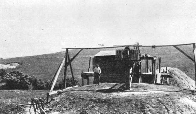
The coal consists of black lignite having the following composition: Water, 13.7 percent; volatile matter, 46.14 percent; fixed carbon, 28.52 percent; and ash, 11.64 percent. It occurs in two layers separated by a maximum of 4 inches of "black jack" or impure coal. The upper layer is 8 inches thick and contains slightly more sulphur and burns more quickly than the lower layers. The lower layer is a foot thick. Both beds burn leaving no soot but a considerable quantity of white ashes similar to those of wood. The coal thickens and becomes deeper to the west. It has been mined principally by the vertical-shaft method, although in some places a sloping shaft has been used. At a few localities the coal has been removed directly from the outcrop of the bed along the creeks.
Clay and Shale
Clay and shale consist of the finest and most insoluble products of weathering. The chief distinction between the two is that clay is less consolidated and does not have the cleavage of shale. There are all gradations, however, and since the two share many uses the terms are used more or less interchangeably. The most important use is in making common brick and tile.
Kansas is a large producer of brick and tile. The clay industry has been located chiefly in the eastern part of the state, due to a combination of favorable conditions including the presence of suitable shales, cheap fuel for burning, and a near-by market. However, the discovery of gas in western Kansas and the piping of this commodity into communities in northern Kansas removes one of the handicaps to the brick-and-tile industry in this part of the state. Local markets will develop, so the only remaining condition for establishing the industry is to find suitable raw material.
The two most favorable deposits in Cloud and Republic counties are the loess of Pleistocene age and the shale of the Dakota formation. The former is a silty deposit of very wide occurrence over the uplands and bluffs of both counties. It is probably the source of the material used in the brick plant at Concordia, which was in operation for a number of years. The Dakota outcrops along the eastern side of Cloud and in the southeastern part of Republic County. Although the formation contains thick beds of sandstone and some of the shale is sandy, it is believed that many places can be found where the shale is suitable for making brick.
Brick and tile require a clay of moderately definite chemical and physical properties, some of which can be determined in the field while others require careful laboratory analysis. Plasticity and texture can be judged by kneading the clay between the fingers. These properties are important in determining whether or not the clay can be molded into desired shapes which it will maintain. The clay should not contain a very large percentage of calcium carbonate, especially in the form of nodules, nor silica in large grains. Other important factors in considering the exploitation of a deposit of clay or shale are the size of the deposit and the amount of overburden (material that will have to be removed before the shale or clay can be recovered). Obviously closeness to market and transportation facilities should be carefully considered.
Water Supplies
Water, where plentiful and of good quality, constitutes one of the most important resources of a region. Less interest commonly is shown in the water supply, however, where it is abundant than where it occurs in limited quantities. Cloud and Republic counties have large areas in which the supply can be classed as unlimited, of excellent quality, and easily obtainable, but in relatively small areas in the two counties water is scarce, or of poor quality. The water resources of Cloud and Republic counties will be discussed according to source.
Surface water
Surface water comes primarily from precipitation in the form of rain and snow, and secondarily from seepage of ground water. The former is more important in the flow of water from the uplands, while the latter causes the continuous, steady flow of water in the streams. Cloud and Republic counties are drained by Solomon and Republican rivers and their tributaries. Both rivers flow from the west through water-bearing formations, and consequently their supply is fairly uniform.
The hill slopes and smaller creeks carry water only during and directly after a rain. The amount of water running off over the surface at any one place depends not only on the character and amount of rainfall but also on the steepness of the surface and the porosity of the underlying soil. Where the slope is steep a greater percentage of the rainfall will join the surface runoff. The same will occur where the underlying soil is clayey or relatively impervious. Ponding this runoff is a simple engineering problem and would supply ample water for farm use. The rainfall is sufficient and other conditions favorable so that no farm in Cloud or Republic counties need be without stock water.
Ground water
River gravel--Cloud and Republic counties are drained by two of the principal tributaries of Kansas river. Solomon river, in southwestern Cloud County, has a flood plain over 3 miles in width, and Republican river, with 30 miles of its course in the western part of Republic County and 30 miles in the northern part of Cloud County, has a flood plain between 2 and 3 miles in width. The flood plain of a stream is the flat valley bottom. It contains, beneath the surface layers of soil and silt, sand and gravel ranging in depth from a few feet up to 60 feet. The sand and gravel in the flood plains of Solomon and Republican rivers obtain a plentiful supply of water through movement down the valley from the west and through seepage from near-by uplands. The material is sufficiently coarse to yield its water readily. Wells producing from flood-plain deposits are assured an unlimited supply that will never fall.
Wells on the flood plains range in depth from a few feet to 20. The deeper wells are on the terraces. The depth to the top of the water is slightly less than the difference in elevation between the place where the well is located and the surface of the water in the river. Many of the wells can be driven, due to the slight depth and the nature of the rock.
Sheet water from the uplands and slopes--Sheet water is ground water that occurs in the soil and slope wash above an impervious bed-rock surface. Thus the shale underlying the uplands in Cloud and Republic counties catches the water percolating down from the surface and prevents it from sinking farther. Because the surface of the shale is not level the water collecting above it will move in the direction of slope, which is generally toward the valleys. The soil veneer above the bed rock has a maximum depth of 40 feet. Wells producing sheet water are dug instead of drilled.
The amount of water obtainable from this source is obviously not great. It depends on the amount of water seeping down from the surface, the porosity of the soil, the degree of concentration of the flow into drainage channels on top of the shale, and the amount withdrawn by local wells. The supply of sheet water has diminished in recent years either because the amount of rainfall has been less or because run-off and withdrawal have been greater, due to settling of the country. This decreased supply has created a critical condition where sheet water is the only water obtainable. While the amount of water in the soil cannot be increased, the conditions under which it occurs will permit much more water to be recovered from the wells than is now obtained. In prospecting in this area an attempt should be made to find those places where the coarse soil or gravel overlying the bed rock is thickest. This can be done by noting the thickness and porosity of the basal materials in each well drilled and locating new wells in the direction toward which the gravels thicken. Also, careful records of the depth to the underlying impervious shale should be kept with the idea of locating new wells where there are depressions or ravines at the top of the shale. Not only may the gravels be thicker in such places, but the sheet water tends to work its way toward them just as it does at the surface. In most cases these channels occur beneath similar ones on the surface, but undoubtedly others exist which have no relation to the present drainage. Where the channels in the shale lie beneath those on the present surface, the greatest supply of water may be expected beneath the fill in the creek bottoms. The supply in any one well may be materially increased by digging the well down to the bed-rock surface and by running tunnels along the top of the shale at right angles to the movement of the water.
Tertiary gravel--The Tertiary gravel, sand, and clay deposits in the northern part of Republic County have already been described. They provide an excellent supply of water, particularly in the old channel between White Rock and Chester. he wells in this relatively narrow belt are drilled to the top of the shale ("slate") where casing is set. The wells near the Republican river are relatively shallow, but in the higher parts of the Tertiary area the wells range between 160 and 220 feet in depth. Part of the water filling this channel undoubtedly comes from the neighboring slopes, but the major part comes from drainage into the channel from Republican river and other sources farther west. The water is of excellent quality and unlimited in amount. The new city wells at Belleville obtain their supply from this source.
The surface of the blue shale outside of the channel is higher and the supply of water is not so plentiful. In fact, the farther the well is located from the channel the higher the shale, the thinner the gravel, and the less the water. The same suggestions that were made in regard to obtaining increased supplies of sheet water apply to wells drilled in the Tertiary outside of the channel. Undoubtedly many of the wells that already produce a plentiful supply have penetrated into tributary channels leading northward into the main channel. Others may. be discovered by noting the slopes of the top of the shale as told from the depths of wells drilled.
Dakota Sandstone--The Dakota sandstone is the principal water-bearing formation in the Great Plains area. It consists of thick beds of sandstone separated by beds of shale. In general, the formation outcrops in a relatively narrow, irregular belt encircling the Great Plains and is covered by younger formations in the center. The western outcrop in Colorado, Wyoming and South Dakota is higher, so that water entering the formation along this belt tends to migrate toward the east. The water in the central part of the area occurs under considerable pressure, so that many of the wells flow. Numerous springs occur along the eastern outcrop of the formation. Two types of water are produced from sandstone members of the Dakota. Careful studies of the flow of water from each sandstone member in North Dakota, South Dakota, and Minnesota have shown that certain of the beds, principally in the upper part of the formation, produce soft water while the lower members yield hard water.
The Dakota underlies all of Cloud and Republic counties. It is at the surface to the east and in the principal valleys, but younger formations overlie it on the uplands. Attempts to obtain water supplies from this formation have met with varying degrees of success. Some of the wells yield an abundant supply of palatable water. The only difficulty in others lies in preventing the pumping of fine sand with the water. This can be overcome by proper screening and pumping. But in some of the wells the water contains so much salt, gypsum, and iron that it cannot be used, even for watering stock. Whether this condition is a local one with all the principal sandstones in the formation yielding salt water or whether this objectionable water comes only from certain beds cannot be determined from data at hand. It seems to the writer, from experience gained elsewhere and through knowledge of the conditions existing in the Dakota, that the wells yielding fresh water produce from different beds than those in which the water is salty. This offers the hope that fresh water may be produced in any locality from the Dakota if the driller will very carefully obtain and test unadulterated samples of water from each and properly case off the strata producing salt water. The discovery of fresh-water horizons in localities where the Dakota has heretofore produced only salt water and where water from other sources is insufficient would be of great value.
Where the Dakota sandstone outcrops the water obtained is clear and fresh, due to leaching of the salt by water which has seeped in from the surface.
Soils
The soil in an agricultural community is an important economic resource. Cloud and Republic counties, with their exceptionally large acreage of "bottom land" and broad flat uplands underlaid by silty loam, are exceedingly well endowed with fertile soil.
Soil is the result of decay and disintegration of rock, and consists chiefly of silt, sand, and larger rock fragments, organic matter, and a varying quantity of compounds such as kaolin and calcium carbonate. It varies, not only in its composition, but also in its thickness, color, and other physical properties. The chemical composition depends primarily upon the composition of the source rock, but the organic life present, the climate, and the slope of the surface also affect the character of the soil. Plants and borers such as worms and insects have an important effect on the composition, color, and drainage of soil. Climate, which includes wind, precipitation, and temperature, affects the amount of weathering of the bed rock, the amount of sediment that is shifted from one place to another and the amount of organic material and lime present. The rainfall in Cloud and Republic counties has been such that the soil contains a moderate amount of organic matter, and the lime has been leached only from the upper soil and is found concentrated at the base of the subsoil. The slope of the surface affects the thickness and nature of the soil. Soil derived from foreign materials may be present on the flat uplands and in the valleys, while on the slopes bed rock is exposed and the soil is thin.
The most important factor, however, in determining the nature of soil is the character of the rock or material from which it is derived. The sources of soil in Cloud and Republic counties are listed in the order of their importance and the resulting soil briefly described.
(1) Loess. Soil derived from the loess overlies most of the upland flats in both Cloud and Republic counties. The soil is a grayish silt loam. It contains some calcium carbonate and is one of the best soils in the area.
(2) Alluvium. The alluvial deposits underlying the flood plains of Solomon and Republican river, and some of their larger tributaries have produced the best soils in the area. They consist of fine sand and silt loams. Drainage on the lower part of the flood plain is poor, but in the higher areas, particularly on the terraces along Republican river, it is much better.
(3) Carlile shale. A considerable part of the soil of the uplands in Cloud County and in relatively small areas in Republic County is derived from the Carlile shale. It consists of reddish clay soil grading into silt loam where the loess is more prominent. The lower 200 feet of this shale produces better soil than the upper, due to its calcium carbonate content. The shale is relatively impervious, and drainage through it is poor.
(4) Slope wash. Extensive areas in Republic County, both gently sloping uplands and valleys, are underlaid by clays and sands washed from the Tertiary formation. The soils here vary from clayey to sandy and are very similar to those derived from the Carlile shale.
(5) Tertiary sand and clay. The soil contains sand near the border of the Tertiary deposits where the overlying loess has been cut away, especially along the creeks. The sand is in part clayey and contains little lime except where mixed with loess. It consequently ranges from red to gray in color.
(6) Dakota shale members. The Dakota shale members weather to gentle slopes except where capped by protecting ledges of sandstone. The soil on the gentle slopes is a sandy silt loam containing some wind-blown material, while beneath the sandstone caps it is clayey and thin. Fortunately the latter areas are relatively small.
(7) Lower Greenhorn and Graneros shales. These formations outcrop on the slopes beneath the Jetmore limestone member. Consequently the soil is clayey and thin. Surface drainage is good, but drainage below very poor.
(8) Jetmore limestone and Pfeifer shale members. The soil is clayey and in places rocky. Due to the steep slopes where the Jetmore limestone member outcrops the soil is relatively thin.
(9) Dakota sandstone members. The soil developed from these members ranges from a sandy loam on gentle surfaces to a rocky soil on steep slopes.
The soils derived from the loess and alluvium are the best in the area, while those derived from shales outcropping on moderately flat surfaces are a close second. Fortunately most of the soil in each county falls into one of these classifications.
Prev Page--Geologic Structure || Next Page--Plates
Kansas Geological Survey, Geology
Placed on web July 24, 2008; originally published May 1930.
Comments to webadmin@kgs.ku.edu
The URL for this page is http://www.kgs.ku.edu/General/Geology/Republic/05_econ.html