![]()
Prev Page--Geologic Formations || Next Page--Economic Resources
Geologic Structure
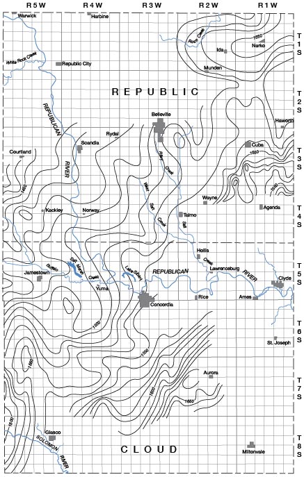
The geologic structure or attitude of the beds is important primarily in the accumulation of petroleum. The surface formations in Cloud and Republic counties have an average dip to the northwest of 10 to 12 feet per mile. There are areas, however, in which the beds dip on one side toward the west and on the other toward the east, as may be seen on the accompanying map. Elevations upon which the contours are based were obtained by means of an altimeter and were taken on the tops of the "shell rock" and "fence post" limestones, the two most satisfactory key horizons in the area. All elevations were checked with those shown on the topographic maps of the United States Geological Survey and each anticlinal structure was confirmed by observation of dips in the field. The structural map does not entirely cover the two counties, due to the fact that the southern and eastern parts of Cloud County and the eastern part of Republic County contain the Dakota formation at the surface, while the northern and western parts of Republic County are underlaid by Tertiary sand and clay. Neither the Dakota nor the Tertiary contains key beds suitable for use in structural mapping.
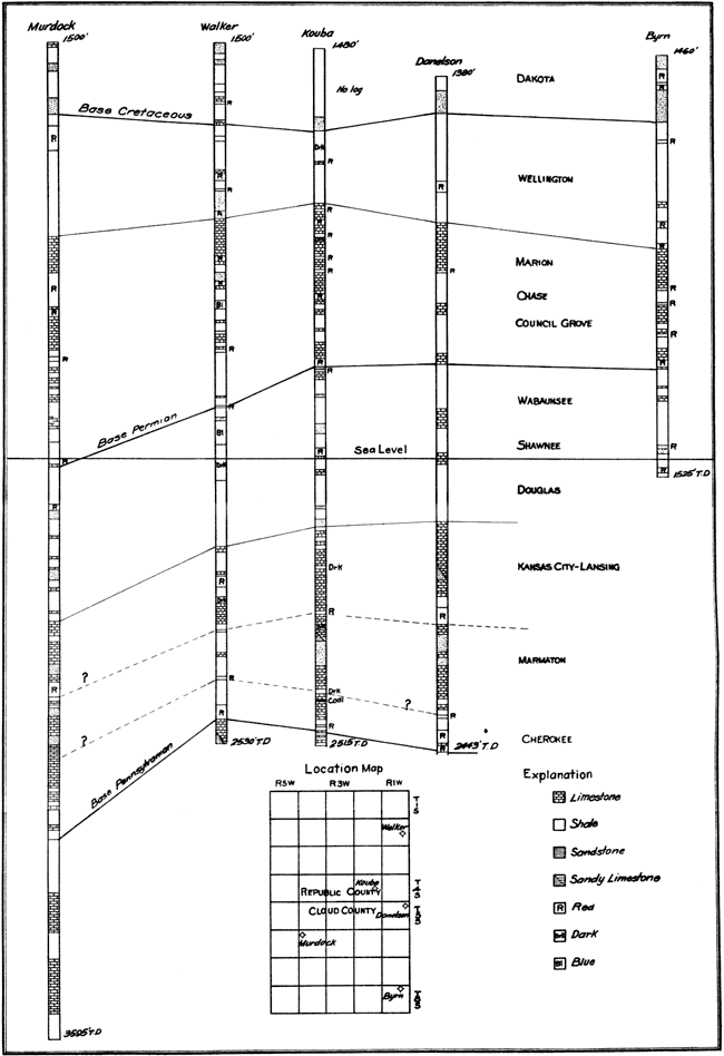
Plate 15--Graphic correlation of well logs. A larger version of this figure is available.
Reference to the map will show that there are a number of moderately prominent structures in both counties that may be considered favorable to the accumulation of oil and gas. These consist of anticlines trending toward the northwest but more or less in alignment with the regional northeast-southwest strike. Before any of these are considered seriously for drilling they should be surveyed in more detail. [Recent investigations by J. W. Ockerman and me show that many of the surface anticlines in north central Kansas do not continue in depths below the Permian.--K. K. Landes]
In Cloud County the most favorable structure extends diagonally from the southeast corner of T. 7 S., R. 5 W. to the northwest corner of T. 6 S., R. 5 W. The highest part of the structure is in secs. 32 and 33, T. 6 S., R. 5 W. and in secs. 4 and 5, T. 7 S., R. 5 W. The dip toward the west is unusually strong, while the difference in elevation of the beds to the northeast is 45 or 50 feet. The structure of the rocks to the southeast could not be determined, for reasons already stated, but there is some evidence that a similar favorable area exists in T. 8 S., R. 4 W. The exact location for a test well on a structure of this kind should be determined by a more detailed survey using plane-table and telescopic alidade.
Unusual dips toward the west and other data indicate another prominent anticline near the center of T. 7 S., R 2 W. Lack of outcrops prevented both the determination of the northern limit and the exact size of this structure, although a plane-table survey would add considerable detail.
A minor structure occurs in the northwest corner of T. 6 S., R. 4 W. This is the site of the McCullough well, which was drilled to a depth of over 3,595 feet without finding oil. A similar anticline is indicated by elevations obtained in the north central part of T. 6 S., R. 3 W. south of Concordia, but data were not sufficient to show its size or exact location. Favorable structures may occur in the Dakota sandstone area, also, but could not be determined from surface observations.
In Republic County the largest anticlinal structure occurs near the center of the west side of T. 1 S., R. 1 W. This is not only the largest structure of the entire area but is the most irregular in shape. The amount of the dip toward the west could not be determined, due to lack of outcrops, but the general dip of the beds in the region is in that direction. Toward the southeast the beds are at least 40 feet lower than at the top of the structure.
A well-defined but small anticlinal nose occurs in the northeast corner of T. 3 S., R. 3 W. Other small anticlines occur in section 21, T. 4 S., R. 5 W. and in the southwest corner of T. 3 S., R. 1 W. The area in the northwest corner of Republic County underlaid by Tertiary sand and clay was not surveyed because of the lack of beds upon which to take elevations. The region is underlaid, however, at relatively shallow depths by easily recognizable limestones, and consequently could be surveyed by means of the core drill.
Plate 16--Reconnaissance structural contour map of Cloud and Republic counties, Kansas. A larger version of this figure is available.
Prev Page--Geologic Formations || Next Page--Economic Resources
Kansas Geological Survey, Geology
Placed on web July 24, 2008; originally published May 1930.
Comments to webadmin@kgs.ku.edu
The URL for this page is http://www.kgs.ku.edu/General/Geology/Republic/04_struct.html