![]()
Prev Page--Contents || Next Page--Geologic Formations
Geography and Topography
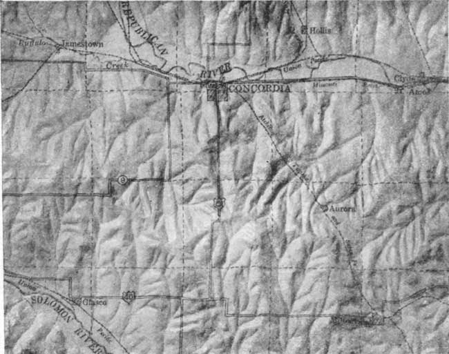
Republic and Cloud counties lie in the first and second tiers of counties respectively from the north border of the state and a short distance east of its center. Each includes a rectangular area 24 by 30 miles with the longer dimension in an east-west direction. Concordia is the county seat of Cloud County, and Belleville of Republic County. In addition, there are the smaller towns of Glasco, Miltonvale, Clyde, Aurora, Ames and Jamestown, in Cloud County, and Scandia, Courtland, Republic City, Munden and Cuba, in Republic County. Warwick, Byron and Chester are along the north line of Republic County, but principally in Nebraska.
Fig. 1--Index map of Kansas showing area described in this report and areas covered by other online geologic reports, as of July 2008. For additional information, please visit the KGS Geologic Maps of Kansas Page.
Railroads--Both counties have exceptionally good transportation facilities. The towns along the northern edge of Republic County are on the main line of the Chicago, Burlington & Quincy railroad between St. Louis and Denver, while a branch of this road runs southwestward through Cuba to Concordia. The Chicago, Rock Island & Pacific railroad crosses Republic County, running east through Courtland and Scandia to Belleville, where it divides, one branch going northeast, through Munden and Narka and the other southeast through Cuba and Clyde. A branch line of the Atchison, Topeka & Santa Fe cuts across the two counties diagonally from southeast to northwest connecting Miltonvale and Aurora with Concordia and extending on through Courtland to Superior, Neb. The Missouri Pacific railroad serves all of the towns in the Republican river valley and has a branch west from Concordia through Jamestown. Branches of the Union Pacific connect Belleville and Talmo and Concordia and Clyde with the main line farther east, while another branch extends up the Solomon river through Glasco. Thus the area here described is served by a total of ten branch or mainline railroads belonging to five of the principal systems.
Highways--In addition to the railroads, state and national highways cross both counties from north to south and from east to west and offer easy access to the area by automobile from all directions. Federal highway No. 81, through Concordia and Belleville, is one of the important north-south routes across the country, connecting Winnipeg, Canada, with Laredo, Tex., on the Mexican border., Federal highway No. 40 north, which is one of the alternate routes through central and western Kansas on the Victory highway connecting Baltimore, Md., and San Francisco, Cal., passes through Cloud County from Miltonvale to Glasco. Federal highway No. 36 runs through Belleville, Scandia and Courtland, in Republic County. While not as prominent nationally as U. S. 40 north, it connects with' that highway near Colby and is one of the principal routes through northern Kansas. It is paved for a short distance west of Scandia. The remainder of the national highway system in these counties is graveled, and by constant maintenance is kept in excellent condition. State highways No. 9 and 2S connect Concordia with Clyde and other towns to the east and with Jamestown, Beloit and towns farther west. Each county has also a good system of county roads.
Agriculture is the most important industry in the area. Small grains, chiefly wheat, and corn are the principal crops on the flat uplands and in the valleys, while the rougher areas are used for grazing. Dairying has been growing in importance the last few years.
Topography--The topography of Cloud and Republic counties presents a wide variety of types. There are the high, extremely flat uplands resembling the Great Plains farther west, the gently rolling Dakota area of eastern Cloud County, the broad flat valleys of the Solomon and Republican rivers and, between the uplands and lowlands a very rough belt consisting of deeply dissected uplands. (Plates V and VI.) Subordinate but interesting topographic features are the sandstone knolls, river terraces and salt marshes. The highest sandstone knolls are the steep-sided twin mounds covered by large irregular blocks of brown sandstone approximately 10 miles southeast of Concordia. Mounds of this character are common in the Dakota sandstone area. River terraces, as prominently developed along the Republican, consist of flats or benches on the sides of the valley, approximately 20 feet above the lower flood plain and separated from it by a steep slope. Excavations and cuts in the terraces show that they are mainly composed of sand and gravel overlaid by silt and soil. It is the remaining part of an older and higher flood plain of the Republican left there when the river in relatively recent times cut a deeper channel and built a new flood plain at a lower elevation. Because of the rich alluvial soil, its flatness and drainage the terrace contains the best farm land in the area.
Plate V--Relief model of Republic County.
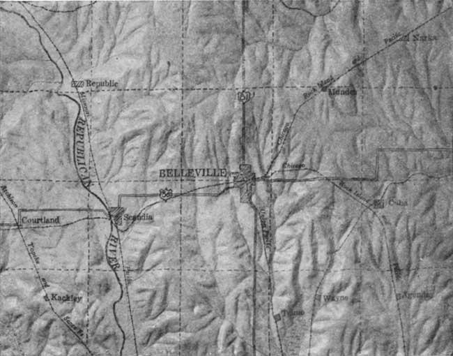
Plate VI--Relief model of Cloud County.
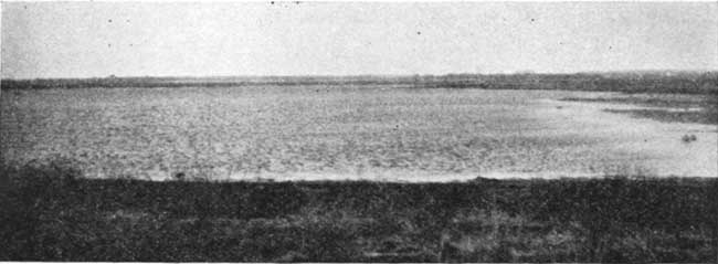
Salt marshes are found northwest of Jamestown in Salt Marsh creek and in the valley south of Wayne and Talmo. In these localities the valley is unusually wide, the valley flat is marshy and the water is salty, leaving a white coating on the surface during dry months. The marsh near Jamestown lies in the Graneros shale, while the one near Wayne is at least 100 feet lower stratigraphically, which places it in the upper shale member of the Dakota sandstone. (See description of formations.) Occurrence of marshes at these horizons and the known presence of salt in the shales suggests that easily soluble salt caused rapid erosion and unusual widening of the valleys at those points where the stream cut into the shale. The width of Buffalo creek near Yuma, six miles east of Jamestown, indicates that the stream first penetrated the salt shale at this point and that, as the creek cut its valley lower, the swamp migrated up stream until it reached its present location four or five miles northwest of Jamestown. Buffalo creek has an extremely low slope or gradient--lower than that of the Republican river into which it flows. Consequently silt and dirt washed into the valley have covered and completely hidden the old marsh throughout most of its length. Slope wash and creek fill have encroached on the marsh near Wayne to such an extent that it is now less than one-fourth of its original size. Salt Marsh creek, north of Jamestown, has been dammed recently and the marsh converted into a broad shallow lake for hunting. The large amount of silt washed into the basin will in a relatively short time entirely fill the lake, creating a flat surface comparable to a flood plain.
Plate IV--Salt marsh lake northwest of Jamestown, Cloud County.
Prev Page--Contents || Next Page--Geologic Formations
Kansas Geological Survey, Geology
Placed on web July 24, 2008; originally published May 1930.
Comments to webadmin@kgs.ku.edu
The URL for this page is http://www.kgs.ku.edu/General/Geology/Republic/02_geog.html