![]()
Prev Page--Ground water || Next Page--Well Records
Geologic Formations and Their Water-bearing Properties
Cretaceous System
Gulfian Series
Dakota Formation
The Dakota formation does not crop out in Graham County but it contains considerable water within a practical drilling depth and should be considered in a discussion of the aquifers in the county. At the time of the investigation no wells were known to produce water from the Dakota but two of the wells visited had been drilled to the Dakota and contained water. In near-by Gove, Trego, and Rooks counties, the Dakota is an important source of ground water in certain areas where shallow ground water is scarce.
The Dakota formation in Kansas consists predominately of clay, shale, and siltstone with lenses of fairly fine-grained sandstone. Many of the sandstone lenses are interconnected and some water-bearing sandstone is present at most localities. The percentage of sandstone in the Dakota formation in the subsurface of Graham County is not known. The thickness of the Dakota formation in Graham County averages about 300 feet. Its depth below land surface ranges from about 1,100 feet in the uplands on the west to about 500 feet in the valleys in the eastern part of the county.
The quality of the water in the Dakota formation in Graham County is not known. According to A. R. Leonard (1952, p. 28) water in the Dakota in Phillips County is so highly mineralized that it is unfit for domestic, stock, or irrigation use. However, according to W. D. Waterman (personal communication) the water in several Dakota wells in Gove County is suitable for,domestic and stock use although too highly mineralized for irrigation.
Graneros Shale
The Dakota formation is overlain by a dark noncalcareous shale that is known as the Graneros shale. It averages about 40 feet in thickness in Graham County and is not known to yield water to wells.
Greenhorn Limestone
The Greenhorn limestone, which consists principally of a series of chalky limestones and calcareous shales, overlies the Graneros shale. The Greenhorn is on the average about 90 feet thick in Graham County and is not known to yield water to wells.
Carlile Shale
Above the Greenhorn limestone is the Carlile shale, which averages about 250 feet in thickness in Graham County. The lower part of the formation, which consists of gray to blue-gray calcareous shale and thin chalk beds, is known as the Fairport chalky shale member. The upper part of the formation consists principally of dark-gray noncalcareous shale and is known as the Blue Hill shale member. At the top of this member is a sandstone or sandy shale zone, which is the Codell sandstone zone. None of the test holes drilled in the area penetrated the Carlile, and logs of oil wells drillled in the county contain very little detailed information, so the character of the Codell in Graham County is not known. It is thought that the upper part of the Carlile shale, presumably Codell sandstone zone, is water-bearing, and one well, 7-21-2bcc1, is believed to obtain at least part of its water from this formation. The water from this well is highly mineralized but is not extremely hard. It would be unsuitable for irrigation because of a high percentage of sodium, and might be unsatisfactory for sustained drinking by children because of a relatively large amount of fluoride.
Niobrara Formation
The oldest rocks to crop out in Graham County consist of the chalk and chalky shale of the Smoky Hill chalk member of the Niobrara formation. The lower member of the Niobrara formation, the Fort Hays limestone member, is not exposed in Graham County.
Fort Hays limestone member--The Fort Hays limestone member is composed of thick massive beds of chalk or chalky limestone separated by thin beds of chalky shale. The beds are light to dark gray when unweathered, but upon weathering they are white, tan, buff, or cream. The Fort Hays underlies the entire area and probably averages about 55 feet in thickness. It is thought that the Fort Hays limestone member contains water in fractures or along bedding planes and that it supplies water to some wells in the area. For example, wells 7-21-2bcc1 and 10-21-30abb probably obtain some water from the Fort Hays. Water from these wells is rather highly mineralized. Water from well 10-21-30abb is very hard, whereas water from well 7-21-2bcc1 is less hard, being similar to water from the Ogallala formation in that respect. In well 7-21-3bcc1, water from the Fort Hays is thought to be modified by water from the Carlile shale.
Smoky Hill chalk member--The Smoky Hill chalk member of the Niobrara formation consists principally of chalk and chalky shale beds, which are light to dark gray in unweathered beds but yellow, orange, tan, or pinkish in weathered exposures (Pls. 5C, 6). The Smoky Hill contains some massive chalk beds similar to beds of the Fort Hays limestone member. Thin bentonite beds and concretions of pyrite or limonite are common as are large fossil shells of Inoceramus grandis and small fossil shells of Ostrea congesta. The formation has undergone considerable deformation, and fractures, small faults, and tilted beds are common in outcrops of the Smoky Hill (Pls. 5C, 6B). Some of the fractures or fault lines are filled with crystalline calcite. In secs. 28, 29, and 32, T. 8 S., R. 25 W., is an area where considerable faulting has occurred. In this locality the Niobrara formation is above the younger Pierre shale in several places for horizontal distance of more than half a mile.
Plate 6--Smoky Hill chalk member of Niobrara formation. A, Chalky shale of the Smoky Hill with a mortar bed of the Ogallala formation at top; NW SW sec. 19, T. 10 S., R. 20 W., Rooks County. B, Small fault in Smoky Hill chalk member in sec. 29, T. 8 S., R. 25 W. Photograph by C. K. Bayne.
Beds of silicified chalk occur at or near the top of the Smoky Hill chalk member at several localities. Silicified chalk zones commonly occur near or are associated with the Ogallala formation. According to Frye and Leonard (1949 p. 30) the silicified zones in the chalk were formed by secondary silicification of the uppermost exposed chalk beds probably at the same time as the silicification of zones in the overlying Ogallala formation.
The entire county is underlain by the Smoky Hill chalk member and it crops out in a large part of the area (Pl. 1). The formation has undergone considerable dissection during Pleistocene time and its thickness is considerably different from place to place. In the upland areas in the northwestern part of the county where the Ogallala formation has protected the Smoky Hill from erosion, the Smoky Hill is as much as 550 feet thick but in the southeastern part of the county where there has been much erosion, it may not be more than 100 feet thick.
The Smoky Hill is generally not an important source of water, but in Graham County it yields water to several wells in areas where water is not available from Pleistocene or Pliocene deposits. The water in the Smoky Hill is thought to be contained in fractures along faults or along bedding planes. The success of a well penetrating either the Smoky Hill or the Fort Hays depends on whether or not these openings are found. Yields of wells to the Niobrara generally are small.
Analyses of samples of water from four wells thought to derive part or all their water from the Smoky Hill are given in Table 3. The water is more highly mineralized and harder than water from the Ogallala but is satisfactory for stock use and most domestic uses.
Pierre Shale
The Pierre shale, which is the youngest formation of late Cretaceous age recognized in Kansas, consists principally of soft fissile blue-gray shale in Graham County. The formation has been studied and described in detail by Elias (1931) who separated the Pierre into six members. Outcrops of Pierre are too few and too thin in Graham County to determine what member is present, but it is probable that the Pierre shale in Graham County consists entirely of the lowermost member, the Sharon Springs shale member. Outcrops of Pierre shale are restricted to four small areas in the western part of the county (Pl. 1). The maximum thickness of the formation observed in outcrops was 18 feet. No Pierre shale was encountered in test drilling and it does not form a continuous layer in the upland areas. The maximum thickness of the Pierre is probably less than 40 feet. The Pierre yields no water to wells in Graham County.
Tertiary System
Pliocene Series
Ogallala formation
The Ogallala formation was named by Darton (1899, pp. 732, 734) from a locality in southwestern Nebraska and its age was considered as late Tertiary or Pliocene(?). In 1920 Darton (p. 6) designated the type locality as being near Ogallala Station in western Nebraska. Since the work of Darton, the most significant studies of Ogallala stratigraphy in western Kansas have been made by Elias (1931), Smith (1940), and Frye and Leonard (1949).
The Ogallala formation is now considered by the State Geological Survey of Kansas to range from early Pliocene or possibly late Miocene to late Pliocene in age. The Ogallala is subdivided into three members which, in ascending order, are: Valentine, Ash Hollow, and Kimball. No attempt to subdivide the Ogallala in Graham County was made.
Character--The Ogallala formation in Graham County consists chiefly of silt, clay, sand, and gravel. Calcium carbonate is a common constituent and occurs as cementing material, as caliche beds, nodules, or stringers, or as layers of impure limestone. Silica occurs as cementing material or in places as beds of opaline sandstone or chert. Some beds of bentonitic clay are found in Graham County but beds of volcanic ash or diatomaceous marl, which occur in other areas, have not been identified in Graham County. The character of the Ogallala is shown in logs of test holes included near the end of the report. In spite of its diversity of rock types, the outcrop pattern of the Ogallala presents a uniformity of aspect that makes the formation readily identifiable.
Sand, the principal constituent of the Ogallala formation, occurs at all horizons. Beds of uniform sand may occur but generally the sand is mixed with gravel, silt or clay; sand grains also occur in beds of impure limestone. Gravel beds containing large amounts of sand, silt, or clay are fairly common but thick beds of uniform gravel are scarce. None were encountered in test drilling. Silt and clay, either mixed with deposits of sand and gravel or in layers, are common in the Ogallala. Beds of silty or sandy clay are greenish-gray, reddish-brown, tan, or gray. If the layers contain a large amount of calcium carbonate they are white. At some places layers contain nodules or stringers of calcium carbonate (caliche), calcium carbonate as cementing material, or calcium carbonate as disseminated particles.
Many of the beds in the Ogallala are cemented or partially cemented with calcium carbonate. At many places where sand and gravel deposits are cemented with calcium carbonate they form rough benches or scarps and are called "mortar beds" because of their resemblance to old mortar. Plate 7A shows a type of mortar bed that is common in the Ogallala of Graham County.
Plate 7--Ogallala formation. A, Mortar beds of the Ogallala formation in the SE SE sec. 31, T. 8 S., R. 24 W. B, Blocks of quartzite, most of which have broken from their original position and slumped down the hill; SE sec. 3 1, T. 7 S., R. 22 W.
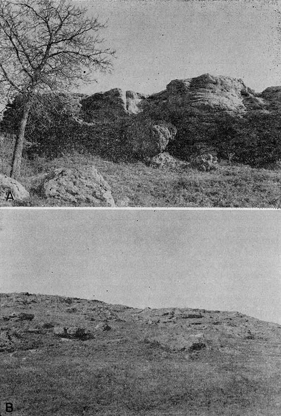
Perhaps the most distinctive rock type in the area is the so-called Ogallala "quartzite." This "quartzite" consists of sand and gravel zones cemented with opaline silica into a very hard rock. In places the sand is fine or medium, the interstices are seemingly filled with cement, and the rock resembles true quartzite. At other localities the rock contains coarse sand or gravel and has little resemblance to quartzite except in respect to hardness. The quartzite, which is typically green in Graham County, generally occurs very close to the base of Ogallala. Outcrops of quartzite are shown in Plates 3A and 7B. A more detailed description of the quartzite in this and other counties is given in a report by Frye and Swineford (1946).
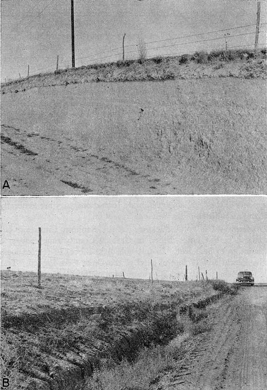
Another distinctive rock type in the Ogallala is the "Algal limestone," which is the uppermost bed in this formation. This limestone has a peculiar concentrically banded structure and was thought by Elias (1931, pp. 136-141) to have been precipitated in quiet water at least in part by the alga Chlorellopsis. Although the "Algal limestone" occurs in many areas in the High Plains and is recognized as far east in Kansas as Lincoln County, only one exposure was found in Graham County. This outcrop was at the bottom of a grader ditch near the SE cor. NE sec. 34, T. 6 S., R. 24 W. Where not exposed in the ditch the "Algal limestone" is covered by 3 or more feet of loess in the locality. During the field work, several other limestone beds were found which lack the concentric algal features of the "Algal limestone" but which are otherwise similar and may be comparable. One such outcrop occurs at the top of a small hill about a quarter mile west of the SE cor. sec. 1, T. 7 S., R. 22 W.
Distribution and thickness--The Ogallala formation at the end of Pliocene time probably covered the entire county with a mantle of sediments that generally were thinner to the east. At the present time the Ogallala still covers much of the area but in places it has been removed completely by erosion. The bedrock beneath the alluvium and terrace deposits of South Fork Solomon River is Niobrara formation, the Ogallala having been removed along the entire length of the stream in Graham County. North and south of the river are bluffs of the Niobrara formation. These bluffs are generally capped by beds of the Ogallala formation in the western part of the county. East of Hill City, however, the Ogallala crops out at a greater distance from the river as erosion of the Ogallala, which was probably originally very thin, has progressed farther in this area (Pl. 1). Some of the bluffs in the vicinity of the river are capped by quartzite of the Ogallala, which has retarded erosion to a considerable extent. For example quartzite outcrops occur in the NE sec. 14, T. 8 S., R. 24 W., and in the NW sec. 29, T. 8 S., R. 23 W.
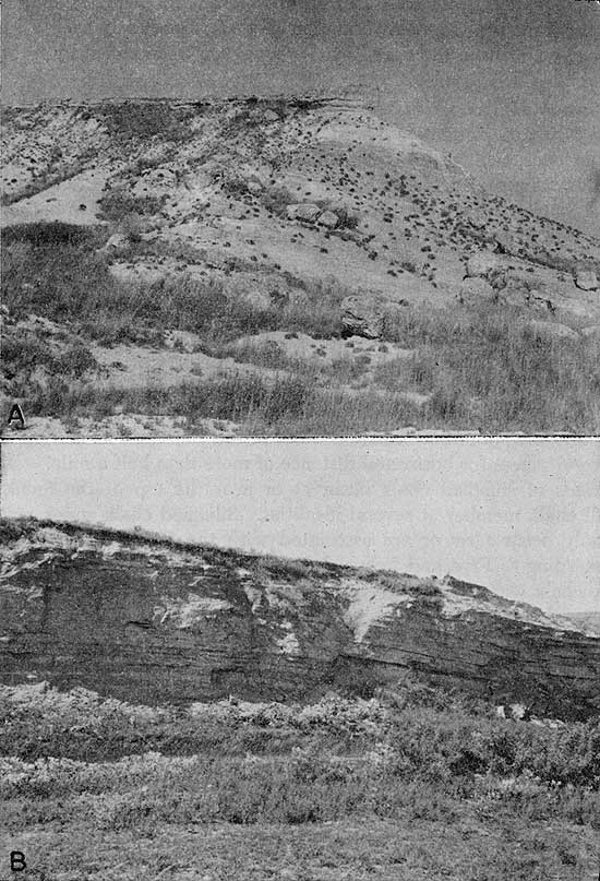
In addition to South Fork Solomon River many other smaller streams have cut through the Ogallala formation and into the Niobrara. This has happened along North Fork Saline River and along the eastern part of Bow Creek, and along many other unnamed tributaries to Saline River, North Fork Saline River, and South Fork Solomon River. Good outcrops of the Ogallala occur along some of these streams. A particularly impressive exposure of the Ogallala occurs along the south bank of North Fork Saline River in the NW sec 23, T. 10 S., R. 25 W. south of St. Peter (Pl. 8). At this locality the Ogallala overlies silicified chalk of the Niobrara and large blocks of silicified chalk have been incorporated into the Ogallala. Another interesting area of Ogallala outcrop is in secs. 22, 23, and 24, T. 7 S., R. 22 W. where the Ogallala forms a ridge. Quartzite caps some of the higher points on the ridge and mortar beds occur below. Sand, washed or blown from the Ogallala, has accumulated south and southeast of the ridge to form a series of low sand dunes. The entire area has the aspect of never having been covered with the loess of the Sanborn formation, which mantles the Ogallala in the uplands in much of the county.
Plate 8--Contact of the Ogallala and Niobrara formations. A, Ogallala formation in the NW NW sec. 23, T. 10 S., R. 25 W. in bluff on south side of North Fork Saline River. Coarse-textured Ogallala resting on silicified chalk of Niobrara formation. Large blocks of silicified chalk are incorporated in the Ogallala. B, Same locality showing the coarse texture of the Ogallala and the contact between the Ogallala and the silicified chalk.
Of the 29 test holes drilled in Graham County, 16 encountered the Ogallala formation. The maximum thickness of the Ogallala was 205 feet in test hole 6-25-31ccc. The thickness of the Ogallala is shown in the cross sections (Fig. 5) and in the logs of the test holes given in this report.
Water Supply--The Ogallala is the most wide-spread water-bearing formation in Graham County. It supplies water to most of the domestic and stock wells in the upland areas and to the only irrigation well that was used in 1952. Many springs obtain water from the Ogallala but only a few of the springs are listed in Table 7. The yield of the wells ranges from a few gallons a minute for domestic and stock wells to about 400 gallons a minute for irrigation well 7-22-10bcb. Logs of test holes indicate that much of the water-bearing material consists of sand and gravel, which may store or yield large amounts of water. The geologic cross sections (fig. 5) indicate that in most of the county, although water-bearing materials in the Ogallala may be relatively coarse and may contain sufficient water for domestic and stock purposes, they are generally too thin to permit the pumping of amounts of water sufficient for irrigation.
Water samples were collected from nine wells that derived their water from the Ogallala formation. The analysis listed in Table 3 indicate that the water from the Ogallala is fairly uniform in quality and is of better quality than water from the other formations. Although the water is moderately hard, it is generally of good quality both for domestic use and for irrigation.
Quaternary System
Pleistocene Series
Deposits of Quaternary age constitute the surficial material in much of Graham County. Where they occur in the valleys they are an important source of ground water. The Quaternary deposits in Graham County are the Meade formation, Sanborn formation, dune sand, and alluvium.
Meade Formation
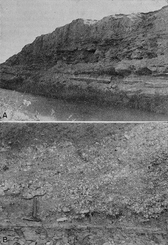
Deposits of Kansan age (Meade formation) occur as remnants of a high terrace in scattered outcrops principally along South Fork Solomon River (for example, in road cuts along U. S. Highway 24 in the NW sec. 18, T. 8 S., R. 24 W., the NW sec. 14, T. 8 S., R. 23 W., and the SE sec. 14, T. 8 S., R. 21 W.). Other exposures of the Meade formation have been identified in southwestern Graham County in the SW sec. 18 and NW sec. 19, T. 10 S., R. 24 W. along a tributary to North Fork Saline River and in sec. 35, T. 10 S., R. 23 W. along a tributary to Saline River. The Meade formation consists of two members, the Sappa member above and the Grand Island member. The Sappa member is composed principally of silt with small amounts of sand and gravel. In the SE sec. 4, T. 8 S., R. 25 W., the combined thickness of the Sappa and Grand Island is about 25 feet. The Sappa at this locality consists chiefly of light-tan silt and fine sand. It also contains layers of greenish-gray clay. In the SW SE sec. 14, T. 8 S., R. 21 W. the Sappa consists of about 11 feet of light-tan fine sand and silt. In the NE SW sec. 11, T. 8 S., R. 25 W., the Sappa consists principally of silt but contains a 6-foot bed of volcanic ash, the Pearlette volcanic ash bed, which is an important marker bed and whose presence simplifies the identification of the Sappa member. The Pearlette volcanic ash bed has also been identified in the SW sec. 18, T. 10 S., R. 24 W. (Pl. 9A). The Grand Island member has been identified in exposures in the SW sec, 18 and NW,4 sec. 19, T. 10 S., R. 24 W.; SW SE sec. 14, T. 8 S., R. 21 W.; and SE sec. 4, T. 8 S., R. 25 W. A test hole drilled at the SE cor. sec. 14, T. 8 S., R. 21 W. encountered 55 feet of deposits that are thought to be Meade formation. The Meade formation has been mapped with the Sanborn formation (Pl. 1). Outcrops of the Meade formation are small and generally lie above the water table in Graham County and yield no water to wells. However, one well that was inventoried (8-21-26dcd) obtained water from deposits that may be Meade formation. This well, located in a small draw tributary to the South Fork Solomon River, is thought to obtain water from beds that may have been deposited by tributary streams in Kansan time.
Plate 9--A, Pearlette volcanic ash bed in Sappa member of Meade formation. Ash is the white bed near center of picture. Peoria silt member of the Sanborn formation at top of exposure and chalk of the Niobrara formation at base; NE SW sec. 18, T. 10 S., R. 24 W. B, Cross-bedded sand in the Crete sand and gravel member of the Sanborn formation; SW SE sec. 7, T. 8 S., R. 22 W.
Sanborn Formation
The name Sanborn formation was first used in 1931 by Elias (pp. 163-180) for unconsolidated Pleistocene deposits, consisting mainly of silt but with some sand and gravel at the base, that are widely distributed on the divides of western Kansas. The deposits were named for the town of Sanborn, Nebraska, which is just north of the type locality in northwestern Cheyenne County, Kansas. Since the work of Elias the formation has been more specifically defined and has been subdivided and expanded to include, in ascending order, the following members: (1) Crete sand and gravel member; (2) Loveland silt member, commonly containing the fossil Sangamon soil at its top; (3) unnamed early Wisconsinan alluvial deposits; (4) Peoria silt member, commonly containing the fossil Brady soil at its top; (5) unnamed late Wisconsinan alluvial deposits; and (6) the Bignell silt member (official classification of the State Geological Survey of Kansas, Frye and Leonard, 1952, p. 106). All subdivisions except early Wisconsinan alluvial deposits were recognized in Graham County.
Crete sand and gravel member--The basal member of the Sanborn formation is the Crete sand and gravel member, which represents the major channel fills of Illinoian age. Deposits of the Crete are widespread throughout the county and occur in terrace position along many of the streams. In places the Crete is exposed in vertical banks and is overlain by either the Loveland silt member or the Peoria silt member. In the W2 sec. 15, T. 8 S., R. 25 W., the Crete lies on Pierre shale and Niobrara and is overlain by the Peoria silt member. The thickness of the Pleistocene section at this locality is approximately 30 feet. In the SE SW sec. 5, T. 8 S., R. 22 W. the Crete lies on Niobrara and is overlain by the Loveland silt member which in turn is covered by the Peoria silt member. Other good exposures of the Crete occur in the SE sec. 7, T. 8 S., R. 22 W. (Pl. 9B) and in the SW NW sec. 9, T. 8 S., R. 23 W. Generally the Crete is mantled by varying thicknesses of silt of the Sanborn and does not crop out or consists of a narrow band of sand and gravel at the base of a vertical bank composed principally of loess. Outcrops of Crete shown on Plate 1 do not represent its maximum extent but rather are occurrences which are not covered by thick loess and which are mappable as Crete rather than Sanborn formation undifferentiated. The Crete was encountered in test holes 8-21-17dbb, 8-23-2ddd, and 8-23-12bcc, its maximum thickness being 17 feet in 8-23-12bcc.
Loveland silt member--The Loveland silt member has been identified in outcrops in Graham County and has been recognized in drill cuttings but its occurrence is thought to be sporadic. Seemingly it does not form a continuous blanket over the divide areas as does the Peoria silt member, which overlies it. The loess of the Loveland is tan where unaffected by weathering, but generally it is identified by the Sangamon soil (formed at the top of the Loveland during Sangamonian time), which is dark brown and which contains a high percentage of clay. Some of the Loveland exposures in the county are in the NW NE sec. 7, T. 8 S., R. 21 W.; SE SW sec. 5, T. 8 S., R. 22 W.; and NW sec. 14, T. 8 S., R. 23 W. Loveland was recognized in test holes 6-22-4aaa, 7-21-23add, and 7-22-1aaa. In test hole 6-22-4aaa the Loveland was 13 feet thick.
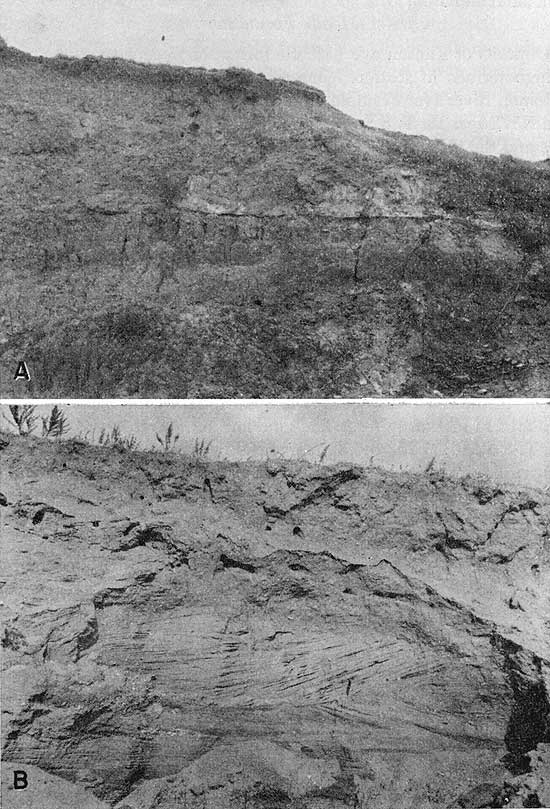
Peoria silt member--The Peoria silt member is widespread in Graham County and has been recognized in all parts of the county where it overlies formations of Pliocene or Cretaceous age. The Peoria consists of a tan or yellowish-gray silt, which presumably was blown from the flood plains of the Platte and Republican Rivers during early Wisconsinan time (Swineford and Frye, 1951). The Peoria is in places terminated upward by the Brady soil, which is a dark-brown to black soil generally slightly thicker than the modern soil. Where the Brady soil occurs, it is overlain by the Bignell silt member, which is the uppermost silt member of the Sanborn (Pl. 10).
Plate 10--Outcrops of the Sanborn formation. A, Exposure of Peoria silt member of Sanborn formation in road cut; NW SE sec. 2, T. 8 S., R. 25 W. B, Bignell silt member and Peoria silt member of Sanborn formation separated by Brady soil. Soil is about 1 foot thick and is underneath hammer; NE NW sec. 9, T. 10 S., R. 25 W.
Bignell silt member--The Bignell silt member, which consists of 3 to 4 feet of tan silt in a typical exposure in a road cut in the NE NW sec. 9, T. 10 S., R. 25 W., occurs sporadically throughout the area (Pl. 9B).
Terrace deposits--Stream deposits underlie a broad low terrace that forms a considerable part of the floor of the South Fork Solomon River Valley throughout its length in Graham County. Alluvial deposits in terrace position also occur in valleys tributary to South Fork Solomon and Saline Rivers and in Bow Creek Valley. These deposits represent essentially a single cycle of terrace development although minor breaks in level suggest that the terraces were developed during several episodes of cut and fill. The terrace deposits are principally late Wisconsinan in age, although possibly some of the basal materials are early Wisconsinan and some of the uppermost material may be early Recent.
The terrace deposits along South Fork Solomon River consist principally of sand and gravel that has been derived from older alluvial deposits or from the Ogallala formation. The deposits also contain fragments of Cretaceous bedrock and considerable sand and silt. The basal part of the terrace deposits of Bow Creek consists principally of sand and gravel, but the upper part is mostly silt. Some of this silt may be wind blown and may be correlated with the Bignell silt member as the Bignell and the terrace deposits are essentially of the same age. Some of the silt may also be colluvial. Upper Wisconsinan terrace deposits along the smaller streams contain a large percentage of fine materials. Included with the terrace deposits along the smaller streams are deposits of Recent alluvium which are too narrow to be shown on a map of the scale used in this report.
Slope deposits--Included with the Sanborn formation on the geologic map (Pl. 1), although not properly classified as Sanborn, are colluvial materials mantling some of the slopes. The colluvium or slope deposits consist mainly of silt of the Sanborn formation that has been redeposited during Recent time by the action of wind, surface water, or soil creep. Although the slope deposits may include fragments of the Ogallala or Niobrara formations, they are generally indistinguishable from the Sanborn formation.
Thickness--The total thickness of the Sanborn formation encountered in test holes drilled in Graham County ranged from a featheredge to 52.5 feet. In test hole 8-23-12bcc, 16 feet of loess of the Peoria and 17 feet of sand of the Crete were logged. Test hole 6-22-4aaa penetrated 20 feet of loess of the Peoria and 13 feet of loess of the Loveland. Several test holes were drilled through late Wisconsinan terrace deposits. The maximum thickness of the deposits was 52.5 feet in test hole 6-21-7add drilled on the north side of Bow Creek in the northeastern part of the county. A test hole just northeast of the city light plant on the north side of the South Fork Solomon River drilled by C. A. Robben for Hill City penetrated 38 feet of terrace deposits and in irrigation well 8-21-7cbc 51 feet of terrace material was encountered.
Water supply--The silt members of the Sanborn lie above the water table and yield no water to wells in Graham County. The Crete member, however, is a source of water to wells in some places where it occurs along the valleys. The municipal water supply at Bogue is obtained from Crete deposits and several other wells that were inventoried also obtain water from the Crete. Two water samples were collected from wells that tap the water-bearing beds of the Crete. Water from well 8-22-8bcc is of good quality, being similar to water from the Ogallala, but water from wells 8-21-8dcc and 8-21-17acb (the Bogue municipal well--for which an analysis is available) is more highly, although not excessively, mineralized.
The late Wisconsinan terrace deposits constitute an important source of ground water in Graham County. They yield water to a few irrigation wells, and to the municipal wells at Hill City. The lower water-bearing part of the deposits is commonly rather coarse-textured and contains a considerable amount of water, especially in the valley of South Fork Solomon River. In most places (most of Bow Creek excepted) where Wisconsinan terrace deposits occur, they lie on Cretaceous bedrock and are therefore below the base of the water-bearing zone in the Ogallala formation. Consequently, the water table in the terrace deposits is not connected with the water table in the Ogallala formation of the uplands. In places where the Crete member of the Sanborn carries water, water may move from the Crete into the terrace deposits, thus contributing to the recharge of the terrace deposits. The bulk of the recharge is probably received from precipitation directly on the terrace surfaces. Ground water moves laterally through the Wisconsinan terrace deposits into the alluvium or directly into the streams. Because of the narrow extent of the terrace deposits it is impractical to show water-table contour lines in other than South Fork Solomon River and Bow Creek valleys.
The chemical character of water in the terrace deposits is shown in Table 3 and Figure 7. The water is generally considerably harder and more highly mineralized than water in the Ogallala formation.
In general, water in the Crete member and in terrace deposits along South Fork Solomon River increases in dissolved solids content from west to east. The increase is due principally to the increased calcium sulfate content, which presumably is derived from the Niobrara formation.
Dune Sand
Deposits of dune sand occur in several places in the eastern part of South Fork Solomon Valley and in two other areas. One of these is located principally in sec. 25, T. 7 S., R. 22 W. but extends into several neighboring sections; the other area of dune sand is principally in sec. 6, T. 10 S., R. 21 W., and sec. 1, T. 10 S., R. 22 W. The dunes are composed predominantly of fine to coarse sand, which has been accumulated by the wind to form small hills. Most of the sand dunes are vegetated but in places areas of bare sand are being subjected to renewed wind action. The dune sand in the valley of South Fork Solomon River probably was derived from the alluvium and terrace deposits and was blown only a short distance. The sand in sec. 25, T. 7, S., R. 22 W. and neighboring sections was blown or washed from near-by Ogallala outcrops and accumulated by the wind to form dunes. The sand in sec. 6, T. 10 S., R. 21 W. and sec. 1, T. 10 S., R. 22 W. was probably derived principally from the Ogallala formation. The thickness of the dune sand in Graham County is not known but it probably does not exceed 15 or 20 feet.
No wells in Graham County are known to obtain water from the dune sand, but the dunes, because of their high permeability, serve as intake areas for ground-water recharge from local precipitation.
Alluvium
Deposits of Recent alluvium occur along the channel of South Fork Solomon River. Alluvium also exists in the channel of Bow Creek and many of the smaller streams. However, in these areas the alluvium cannot be shown on a map having the scale used in Plate 1 without great exaggeration, and consequently, the alluvium is included with the Wisconsinan terrace deposits. The alluvium of South Fork Solomon River consists principally of sand and gravel with lesser amounts of silt and clay. The alluvium of smaller streams contains a larger percentage of silt and contains materials derived from terrace deposits and fragments of Cretaceous bedrock. The alluvium of the smaller streams is more poorly sorted and less permeable than the alluvium of South Fork Solomon River.
The body of ground water in the alluvium is continuous with the body of ground water in the late Wisconsinan terrace deposits. Although the alluvium contains a considerable amount of ground water, very few wells obtain water from alluvium because it is generally restricted to the stream channels.
Prev Page--Ground water || Next Page--Well Records
Kansas Geological Survey, Geology
Placed on web Feb. 13, 2009; originally published August 1955.
Comments to webadmin@kgs.ku.edu
The URL for this page is http://www.kgs.ku.edu/General/Geology/Graham/06_form.html