![]()
Prev Page--Contents || Next Page--Geography
Introduction
Purpose and Scope of the Investigation
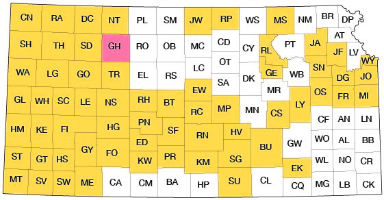
The investigation upon which this report is based is part of a program of ground-water investigations in Kansas begun in 1937 by the United States Geological Survey and the State Geological Survey of Kansas in cooperation with the Division of Water Resources of the Kansas State Board of Agriculture and Division of Sanitation of the Kansas State Board of Health. The present status of investigations made under this program is shown in Figure 1.
Figure 1--Index map of Kansas showing area described in this report and areas covered by other online geologic reports, as of Feb. 2009. For additional information, please visit the KGS Geologic Maps of Kansas Page.
The investigation of the geology and ground-water resources of Graham County was made to determine the availability and quality of ground water for domestic, stock, industrial, and irrigation supplies and to determine the geologic and hydrologic factors that control the occurrence of ground water, which is one of the principal natural resources of western Kansas. Although at the present rate of withdrawal, the danger of seriously depleting the ground-water supply seems very slight, there still is a definite need for an adequate understanding of the quantity and quality of the available supply, where additional supplies can be obtained, and what measures may be necessary to safeguard their continuance. The investigation was made under the general direction of A. N. Sayre, chief of the Ground Water Branch of the U. S. Geological Survey, and under the immediate supervision of V. C. Fishel, district engineer in charge of ground-water studies in Kansas.
Location and Extent of the Area
Graham County, which is near the eastern edge of the High Plains, is bordered on the north by Norton County, on the east by Rooks County, on the South by Trego County, and on the west by Sheridan County. It is in the second tier of counties south of the Kansas-Nebraska State line and is four counties east of the Kansas-Colorado State line. It includes 25 townships--Ts. 6 to 10 S. and Rs. 21 to 25 W. inclusive--and has an area of about 891 square miles. The location of the county is shown in Figure 1.
Previous Investigations
In 1897 several reports on the geology of western Kansas were published by the University Geological Survey of Kansas (Haworth, 1897, 1897a; Logan, 1897; Williston, 1897, 1897a). In the same year a report of the Board of Irrigation Survey and Experiment to the State Legislature of Kansas (Haworth, 1897b) contained a section on the principles of occurrence of ground water and a discussion of the water-bearing beds of western Kansas and included a geologic map of Kansas, geologic cross sections, and a reconnaissance hydrographic map of western Kansas.Johnson (1901, 1902) made special reference to the source, availability, and use of ground water in western Kansas. The first specific reference to Graham County was in a report by Darton (1905) in which he discussed briefly the geology and water supply of the county. Partial chemical analyses of samples of well water from Graham County were given in a report by Parker (1911). A chapter of a special report on well waters in Kansas (Haworth, 1913) was devoted to the Tertiary area of western Kansas, which includes Graham County.
A report on the geology of Wallace County (Elias, 1931) contained the results of detailed studies of Pleistocene, Pliocene, and Cretaceous deposits in the western Kansas area. A report by Landes (1937) briefly summarized the principal aquifers and mentioned the undeveloped mineral resources of the area. Reports on geology and ground-water resources have been published for Norton and northwestern Phillips counties (Frye and Leonard, 1949) and for the North Fork Solomon River Valley in Mitchell, Osborne, Smith, and Phillips counties (Leonard, 1952). In 1952 field work was completed and reports on the geology and ground-water resources are in preparation for Sheridan, Gove, Decatur, and Rawlins counties. Byrne, Coombs, and Matthews (1951) give the results of an investigation of the construction materials in Graham County and prospecting for and development of petroleum in Graham County are summarized by Ver Wiebe (1940, 1941, 1942, 1943, 1944, 1945, 1946, 1947) and Ver Wiebe and others (1948, 1949, 1950, 1951, 1952, 1953, 1954). An important contribution to the literature on Pleistocene geology was made in 1952 by the publication of a report on the Pleistocene geology of Kansas (Frye and Leonard, 1952).
Methods of Investigation
Approximately 4 1/2 months in the summer and fall of 1952 were spent in the field collecting the data upon which this report is based. A total of 344 wells and springs was visited and total depth and depth to water of wells were measured where possible. Well owners and drillers were interviewed regarding the nature and thickness of the water-bearing formations, the yield and drawdown of the wells, and the quality and permanency of the water supply.
Samples of water from 18 wells were collected; they were later analyzed in the Water and Sewage Laboratory of the Kansas State Board of Health at Lawrence by Howard A. Stoltenberg. Three other analyses by Mr. Stoltenberg not made especially for this investigation have been used in the report.
During the course of the investigation the surficial geology was studied and mapped on aerial photographs and the geologic map (Pl. 1) was later prepared in the office. C. K. Bayne assisted in the mapping of geologic features in the valley of the South Fork Solomon River. To determine the character of the material beneath the surface, 29 test holes were drilled by Norman W. Biegler, William T. Connor, and William Gellinger using the hydraulic-rotary drilling rig owned by the State Geological Survey. Samples from the test holes were collected and studied in the field by Biegler, who also prepared logs of the holes.
The altitudes of the surface at the test holes and of the measuring point of wells were determined with a plane table and alidade by level parties headed by Edwin Rhine and Woodrow Wilson. The water-table contour map (Pl. 1) is based on these altitudes together with the measured depth to water in the wells. Wells shown on this map and the well-location map (Pl. 2) were located within the sections by use of an odometer. The base map used for Plates 1 and 2 was adapted from a map compiled by the United States Department of Agriculture, Soil Conservation Service. Road corrections were made by field observations or by use of aerial photographs. The drainage on Plates 1 and 2 was adapted from a map of the Soil Conservation Service.
Well-numbering System
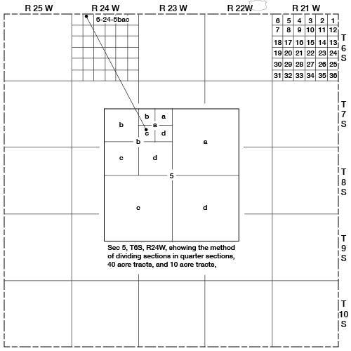
The well and test-hole numbers used in this report give the location of wells according to General Land Office surveys and according to the following formula: township, range, section, 160-acre tract (quarter section), 40-acre tract within that quarter section, and 10-acre tract. If two or more wells are within the same 10-acre tract the wells are numbered serially in the order in which they were inventoried. An example of this well-numbering system is given in Figure 2 where well 6-24-5bac, a well in the SW NE NW sec. 5, T. 6 S., R. 24 W., is shown.
Figure 2--Map of Graham County illustrating the well-numbering system used in this report.
Prev Page--Contents || Next Page--Geography
Kansas Geological Survey, Geology
Placed on web Feb. 13, 2009; originally published August 1955.
Comments to webadmin@kgs.ku.edu
The URL for this page is http://www.kgs.ku.edu/General/Geology/Graham/02_intro.html