![]()
Prev Page--Geography || Next Page--Ground water
General Geology
Summary of Stratigraphy
[Note: The classification and nomenclature of the rocks described in this report follow that of the State Geological Survey of Kansas. They differ somewhat from the classification and nomenclature given in formal reports of the U. S. Geological Survey.]
The rocks that crop out in Graham County are sedimentary and range in age from late Cretaceous (Gulfian) to Recent. A generalized section of the geologic formations is given in Table 2, their areal distribution is shown on Plate 1, and their stratigraphic relationship is shown in Figure 5.
Table 2--Generalized section of geologic formations and their water-bearing properties.| System | Series | Formation | Member | Thickness, feet |
Character | Water supply |
|---|---|---|---|---|---|---|
| Quaternary | Pleistocene* | Alluvium | 0-20 | Sand, gravel, and silt in stream channels and underlying the flood plains. Along minor streams it is poorly sorted and contains a greater percentage of fine materials. | Contains much water but generally restricted to stream channels and consequently yields water to few wells. | |
| Dune sand | 0-20 | Fine to course wind-deposited sand. | Generally lies above the water table and yields no water to wells. Serves as an intake area for ground-water recharge from local precipitation. | |||
| Sanborn formation |
Terrace deposits (late Wisconsinan) |
0-55 | Sand, gravel, silt and clay derived principally from older alluvial deposits and from the Ogallala formation. Deposits along Bow Creek are generally fine-textured in upper part. Deposits along tributary streams are generally poorly sorted and fine-textured. | Yields abundant supplies of water to wells along South Fork Solomon River and eastern Bow Creek. Yields smaller supplies to wells in trbutary valleys. | ||
| Bignell silt member |
0-4 | Light-tan silt that occurs in scattered localities. | Lies above the water table and yields no water to wells. | |||
| Peoria silt member |
0-30 | Light-tan to yellowish-gray silt that mantles the uplands in much of the area. In places is terminated upward by the Brady soil. | Lies above the water table and yields no water to wells. | |||
| Loveland silt member |
0-15 | Massive tan to reddish-tan silt with thick Sangamon soil at top. | Lies above the water table and yields no water to wells. | |||
| Crete sand and gravel member |
0-25 | Sand and gravel with some silt and clay. Generally overlain by loess of the Loveland or Peoria. | Yields water to some wells in valley areas where it lies below the water table. | |||
| Meade formation |
Sappa member* |
0-15 | Silt, clay, and fine sand. Contains the Pearlette volcanic ash bed. Occurs in only a few places. | Lies above the water table and yields no water to wells. | ||
| Grand Island member* |
0-15 | Sand, gravel, silt, and clay. Occurs in only a few places. | Generally lies above the water table, but may yield water to a very few wells. | |||
| Tertiary | Pliocene | Ogallala formation |
Kimball,* Ash Hollow,* and Valentine* members |
0-215 | Sand, gravel, silt, and clay, predominantly calcareous. May be consolidated or unconsolidated. Contains beds of limestone, caliche, and "quartzite." | Yields abundant supplies of water to wells in much of the county. Supplies water to springs in some areas where eroded below the water table. |
| Cretaceous | Gulfian* | Pierre shale |
Sharon Springs (?) member |
0-40 | Soft, fissile blue-gray shale. | Yields no water to wells. |
| Niobrara formation |
Smoky Hill chalk member |
100-550 | Chalk and chalky shale, blue-gray, yellow, and tan. Contains a silicified zone and some bentonite. | Yields a small amount of water to wells. | ||
| Fort Hays limestone member |
40-60 | Chalk and chalky limestone with some thin beds of chalky shale. Light to dark-gray. Not exposed in Graham County. | Yields a small amount of water to wells. | |||
| Carlile shale |
Blue Hill shale member |
250± | Dark-gray noncaleareous shale. Contains a sandy zone called Codell sandstone zone at top. Not exposed in Graham County. | Codell sandstone zone yields a small amount of highly mineralized water. | ||
| Fairport chalky shale member |
Gray to blue-gray calcareous shale. Not exposed in Graham County. | Not known to yield water to wells in Graham County. | ||||
| Greenhorn limestone |
90± | Gray chalky shale and chalky limestone. Not exposed in Graham County. | Not known to yield water to wells in Graham County. | |||
| Graneros shale |
40± | Dark-gray noncalcareous shale. Not exposed in Graham County. | Not known to yield water to wells in Graham County. | |||
| Dakota formation |
300± | Clay, shale, and siltstone with lenses of fine-grained sandstone. Underlies the surface at depths ranging from 500 to 1,100 feet. | Contains water of questionable quality. Two wells in Graham County contain water from the Dakota but are not used. | |||
| *Classification of the State Geological Survey of Kansas. | ||||||
Figure 5--Geologic cross sections in Graham County. A larger version of this figure is available.
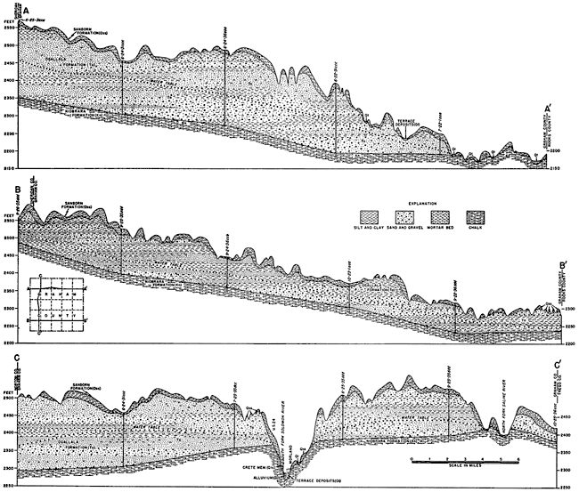
The oldest rocks exposed in the county belong to the Smoky Hill chalk member of the Niobrara formation. The entire county is underlain by this formation and a large part of the county is within the area of outcrop of the Niobrara. The lower member of the Niobrara formation, the Fort Hays limestone, does not crop out in the county. The Pierre shale, which reaches a thickness of about 1,400 feet in the northwestern part of the State (Elias, 1931, p. 50) has almost entirely been eroded away here and has been recognized in only a few outcrops in the western part of the county. The Ogallala formation of Tertiary (Pliocene) age overlies the Niobrara or Pierre over much of the area, but in many places the Ogallala has been completely removed and Cretaceous rocks are exposed. Eolian silt of the Sanborn formation of Pleistocene age mantles the uplands and valley walls over most of the county. Along many stream valleys this silt may be underlain by stream-deposited sand and gravel (Crete member of the Sanborn) in a terrace position with respect to the valley. Terrace deposits (Meade formation') of an earlier aggradational cycle lie* in places along South Fork Solomon River and some of the other creeks, and late Wisconsinan to Recent deposits occur along many of the streams as alluvium or terrace deposits. In small local areas Recent winds have formed dunes of sand from alluvial deposits or from the Ogallala formation.
Rocks not Exposed
The Niobrara formation in Graham County is underlain by approximately 400 feet of deposits consisting principally of shale and limestone. Included herein are the Carlile shale, the Greenhorn limestone, and the Graneros shale. The Codell sandstone zone in the Blue Hill shale member of the Carlile is thought to supply water to a few wells in Graham County, but the Greenhorn limestone and Graneros shale are generally not aquifers. Beneath the Graneros shale is the Dakota formation, which is an important aquifer in some areas in Kansas and which may be a potential source of water for wells in Graham County. These formations will be discussed in more detail in the section on geologic formations and their water-bearing properties.
Geomorphology
The principal topographic features of Graham County are the result of events that happened during Pliocene and Pleistocene time. Near the end of Cretaceous time, the sea that had deposited a great thickness of sediments over the western Kansas area during late Cretaceous time withdrew, exposing the upper part of these beds to subaerial erosion. In early Tertiary time uplift occurred in the Rocky Mountain province and streams flowing eastward across the High Plains area of Kansas stripped off a considerable thickness of upper Cretaceous sedimentary rocks. The Pierre shale was completely removed except in an area in the western part of the county where seemingly the Pierre had been downfaulted or down folded and was therefore protected from erosion. Varying thicknesses of the underlying Niobrara formation were also lost to erosion. In Pliocene time streams from the Rockies deposited large quantities of sediments (Ogallala formation) over the High Plains of Kansas. As the stream valleys became filled, the streams topped the bedrock divides, shifted laterally, and developed an extensive almost featureless plain of alluvium, which merged with the erosional plain in the Rocky Mountain region. The broad alluvial plain was marked in many places with shallow water-table lakes in which the "Algal limestone" was formed.
In early Pleistocene time there was either uplift of the land to the west or a climatic change which caused streams to start cutting valleys below the surface of this vast constructional plain. The sequence of events during Nebraskan and Aftonian time in this area is not known because deposits of these ages have not been identified. However, scattered terrace remnants of Kansan and Yarmouthian age indicate that by Kansan time the major valleys had become entrenched in approximately their present location and that they were later alluviated during Kansan and Yarmouthian time. During the period of erosion which followed, the ancestral South Fork Solomon River entrenched its valley considerably below the base of the Meade deposits (of Kansan and Yarmouthian age). During the period of alluviation which followed, the Crete sand and gravel member (of Illinoian age) of the Sanborn formation was deposited. The aggradational plain that was thus being formed at this time seemingly was subject to strong wind action and it is thought that the loess of the Loveland silt member of the Sanborn formation, which is spread over the upland area, was derived from this source. During late Sangamonian time very little erosion took place and a well-developed soil formed on the silt member of the Loveland loess.
During early Wisconsinan time erosion again took place and streams cut below the Crete member of the Sanborn. This period of erosion is thought to have been followed by rapid alluviation, which brought a large quantity of fine sediments into the valleys of the region. This is suggested by the extensive deposits of windblown silt which form a nearly continuous blanket over the upland areas and valley slopes and which are classed as the Peoria member of the Sanborn formation. Alluvial deposits of early Wisconsinan age have not been identified in Graham County and it is probable that they were removed during a period of erosion later in the Wisconsinan when the major streams did their last extensive downcutting. The period of alluviation that followed in late Wisconsinan or early Recent time produced deposits that are here referred to as late Wisconsinan terrace deposits. The surface of this terrace forms the principal flat area in the valley of the South Fork Solomon River. During late Wisconsinan time high winds again deposited a thin mantle of loess in upland areas. This loess, the Bignell silt member of the Sanborn formation, was deposited on the Peoria silt member, seemingly rather sporadically. In places the top of the Peoria is marked by the Brady soil that had developed prior to the,deposition of the Bignell.
During Recent time, erosion in stream valleys has progressed and the modern streams have cut channels in the late Wisconsinan terrace deposits. Deposits of Recent alluvium occur along the stream channels. Other events that have occurred during Recent time have been the reworking of the sand of Ogallala and terrace and alluvial deposits into dunes and the erosion and slumping of silt of the Sanborn formation to form colluvial deposits that mantle some of the slopes.
Prev Page--Geography || Next Page--Ground water
Kansas Geological Survey, Geology
Placed on web Feb. 13, 2009; originally published August 1955.
Comments to webadmin@kgs.ku.edu
The URL for this page is http://www.kgs.ku.edu/General/Geology/Graham/04_geol.html