![]()
Prev Page--Geology || Next Page--Formations
Ground Water
Source and Occurrence
All the water beneath the surface of the earth is termed subsurface water. The part of subsurface water above the zone of saturation is called suspended water or vadose water, whereas water in the zone of saturation is called ground water. Ground water is the water that is available to wells or springs. In Graham County most of the ground water is derived from precipitation that falls as rain or snow either within the county or in near-by counties to the west. The greater part of the precipitation evaporates, is used by vegetation, or is carried away as surface runoff, but a small fraction enters the ground and eventually joins the body of ground water in the zone of saturation. Water that occurs in the deep-lying Dakota formation and Carlile shale (Codell sandstone zone of the Blue Hill member), neither of which crops out in the county, may be derived partially from local precipitation but probably the major part is obtained in outcrop areas of these two formations where they may receive direct precipitation or where streams flow over the outcrops. Some water may be obtained where the formations are overlain by other water-bearing formations.
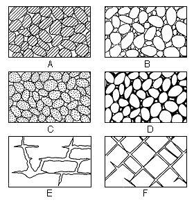
The rocks underlying the surface in Graham County are not solid throughout, but rather they contain voids or interstices, which may contain air, natural gas, oil, or water. There are several different kinds of rocks in Graham County and they differ greatly in the number, size, shape, and arrangement of the interstices, and therefore in their water-holding and water-yielding capacities. The amount of water that can be stored in a rock depends on the porosity of the rock. The percentage of the volume of the rock consisting of interstices is its porosity. Although it is desirable when considering problems of ground-water supply to know the porosity, it is the permeability of the material that determines the rate at which ground water may move. The permeability of a rock is dependent on the size, shape, and interconnection of the interstices. Figure 6 illustrates several types of rock interstices that might occur in Graham County.
Figure 6--Diagram showing several types of rock interstices and the relation of rock texture to porosity. A, Well-sorted sedimentary deposit having high porosity; B, poorly sorted sedimentary deposit having low porosity; C, well-sorted sedimentary deposit consisting of pebbles that are themselves porous, so that the deposit as a whole has a very high porosity; D, well-sorted sedimentary deposit whose porosity has been diminished by the deposition of mineral matter in the interstices; E, rock rendered porous by solution; F, rock rendered porous by fracturing. (From O.E. Meinzer.)
Water in Sand and Gravel
Much of Graham County is underlain by deposits of unconsolidated or partially consolidated material that was laid down by streams during Pliocene and Pleistocene time. The sorting action of streams on the sediments in places resulted in the deposition of distinct beds of gravel, sand, silt, or clay. However, in Graham County well-sorted beds of sand or gravel are not common and in general sand and gravel occur together along with more or less silt and clay. Deposits of uniform coarse sand or gravel may have a high porosity and permeability, but deposits of sand and gravel containing silt and clay will be less porous and less permeable. Uniform deposits of silt, clay, or fine sand may be very porous, but because of the small interstices they will have a low permeability. Properly constructed wells in well-sorted uniform gravel or coarse sand yield large quantities of water.
Sand and gravel in the Ogallala formation and terrace deposits constitute the principal source of ground water in the county.
Water in Limestone and Shale
Chalk, chalky limestone, and chalky shale are generally not important sources of water to wells but several wells in Graham County derive water from such beds in the Niobrara formation. In places the formation has undergone considerable folding, faulting, or fracturing, and water probably occurs in such openings caused or enlarged by water containing dissolved carbon dioxide. The occurrence of fractures and solution openings is irregular and it is generally impossible to predict where water may be found.
Shale is a very poor rock from which to obtain water. Shale is in places highly porous and may contain much water, but because of the small interstices most of the water will be retained by molecular attraction and will not be available to wells. Some water occurs in shale along joints and bedding planes but it is thought that fractures in the more massive beds yield more ground water to wells than the bedding planes and joints in the more shaly beds.
Water in Sandstone
Sandstone yields water to several wells in Graham County. The factors determining the water-bearing properties of a sandstone are the grain size, sorting, and cementation. A coarse-grained, well-sorted sandstone, if not too tightly cemented, will yield water freely, whereas a well-sorted, fine-grained sandstone will yield water less readily. Some sandstones are so tightly cemented they will not yield water from the original openings between the grains, but such sandstones may contain water in joints and fractures.
Details concerning the Codell sandstone zone of the Carlile shale and sandstone of the Dakota formation in Graham County are not available.
Movement
The water table is defined as the upper surface of the zone of saturation except where that surface is formed by an impermeable body (Meinzer, 1923, p. 32), in which case the water table is absent and artesian conditions exist. The water table is not a plane surface but is a sloping surface which has irregularities caused by differences in permeability of water-bearing material, by unequal additions or withdrawals of ground water, and by pronounced irregularities of the bedrock surface. The water table is not stationary but fluctuates in response to additions to or withdrawals from water in storage and to other factors such as changes in barometric pressure.
The configuration of the water table in Graham County where it can be drawn is shown on Plate 2 by means of contours. Water-table contour lines connect points of equal altitude and show the general shape of the water surface just as topographic maps show the shape of the land surface. The direction of movement of ground water is at right angles to the water-table contour lines.
Plate 2 indicates that ground water moves into Graham County generally from the west. It is not practical to draw water-table contours in much of the county because in places there is little or no Pleistocene or Pliocene water-bearing material. This does not necessarily indicate that no ground water can be obtained in such areas but it does mean that the water table is discontinuous and that ground water may be hard to obtain. In such areas some water can be obtained from alluvial or colluvial deposits in draws or from Cretaceous rocks.
Artesian Conditions
Water contained in the Dakota formation, the Codell sandstone zone of the Carlile shale, and generally the Niobrara formation, is under artesian conditions--that is, the water is contained under sufficient pressure to rise above the level at which it is encountered in wells. To be under artesian conditions water must be confined above and below by relatively impermeable beds that dip from the intake area to the area of ground-water discharge. Water entering the permeable bed percolates down gradient and will exert considerable pressure on the upper confining bed, and will rise in a well drilled through the confining layer. If the water is under sufficient pressure and the intake area is at a higher altitude than the surface of the well, the water may flow at the surface. Flowing artesian wells have been reported in Graham County, but none of these reports has been verified.
Recharge
Ground-water recharge is the addition of water to the groundwater reservoir and may be accomplished in several ways.
To Pliocene and Pleistocene Deposits
Recharge to Pliocene and Pleistocene deposits in Graham County is derived from water that falls as precipitation within the county or in adjacent areas to the west.
Although the average annual precipitation of Graham County is about 21 inches, actually only a very small fraction of this (probably less than half an inch) ever reaches the ground-water body. More than 75 percent of the precipitation falls during the months April through September during the height of the growing season when moisture is needed most. A considerable amount of the precipitation during this period is used by plants, some of it being used by the plant in the growth process and some being released to the atmosphere as water vapor by the process known as transpiration. During the same months temperatures are high, wind circulation is good, and consequently the rate of evaporation is high. According to the records of the U. S. Weather Bureau (1950) the rate of evaporation from a free water surface during the growing season as recorded at the Experimental Station at Hays, Ellis County, for the period from 1938 to 1948, is: April, 7.99 inches; May, 9.63 inches; June, 12.04 inches; July, 15.08 inches; August, 13.47 inches; and September, 11.13 inches. It is apparent that the rate of evaporation greatly exceeds the precipitation that falls during this period.
The amount of water from precipitation in Graham County that is lost to runoff is probably not very great. Data are not available for Graham County, but in the Pawnee River Valley in Ness and Hodgeman counties, the average annual runoff has been computed to be 0.3 inch (Fishel, 1952, P. 58). In Cheyenne County the runoff for the area drained by South Fork Republican River was 0.68 inch (Prescott, 1953, p. 33). The runoff in Graham County is probably of a similar order of magnitude.
Part of the water that escapes the processes of runoff, evaporation, and transpiration percolates downward through the soil and underlying formations and eventually reaches the body of ground water. A larger amount of recharge will occur in the valleys where the surficial material is permeable and the depth to water is not great than in the upland areas where the surficial material is rather impermeable and the depth to water is great.
Probably the most important source of water in the Pliocene and Pleistocene deposits in Graham County is subsurface inflow (underflow). Plate 2 indicates that ground water enters the county from the west, which means that some of the water that reaches the water table in adjacent counties to the west moves laterally into Graham County as underflow.
Some recharge is obtained from the loss of water from ponds or from the channels of streams. Many ponds have been constructed in Graham County and, where they are above the water table and not too tightly sealed to prevent downward leakage, they constitute a source of ground-water recharge. Some of the streams lie above the ground-water level and flow only during and after heavy rains. During such periods they are a source of ground-water recharge. Many streams have cut below the base of the Ogallala formation, which is the base of the main zone of saturation, and consequently they cannot add water to the principal body of ground water. Data are too few and valleys too small to permit the drawing of water-table contour lines for other than the valley of the South Fork Solomon River.
To Bedrock Formations
Recharge to the Niobrara formation is similar to recharge of Pliocene and Pleistocene deposits. Some recharge is from precipitation that falls directly on the outcrop area, both within and without Graham County, and some is from streams that flow across the outcrop area. Some recharge also must take place directly from the Ogallala formation where the Ogallala formation contains water and where the upper surface of the Niobrara formation contains cracks or fractures.
Although it may be possible that some recharge to the Codell sandstone zone of the Carlile shale and the Dakota formation may result from downward seepage of local precipitation through overlying beds, probably most recharge to these aquifers takes place in areas where the formations crop out or where they are directly overlain by other water-bearing beds.
Discharge
Ground-water discharge is the discharge of water from the zone of saturation and in Graham County it is accomplished by transpiration and evaporation, by seepage into streams, and by discharge from wells and springs. Ground water also leaves the county by subsurface flow to the east.
Transpiration is one of the principal methods of ground-water discharge in Graham County. Water may be taken into the roots of plants directly from the zone of saturation and may be discharged from the plants by the process known as transpiration. The loss of ground water by transpiration is not significant in upland areas where the depth to water is great but it is of importance in the valleys where the depth to water is shallow and where water-loving plants (phreatophytes) such as alfalfa and cottonwood trees may send their roots deep in search of water. Direct evaporation from the zone of saturation also takes place in areas where the water table is shallow.
The water-table contour lines on Plate 2 indicate that water is moving from the water table to the South Fork Solomon River where the stream level is generally below the level of the water table. Ground water also contributes to the flow of Bow Creek in its eastern reach in Graham County. Several other smaller creeks are spring-fed and contain flowing water. Springs are common in the county and generally occur in draws at or near the contact between the water-bearing beds of the Ogallala formation and the underlying impermeable Niobrara formation. The amount of water discharged by springs is not known.
The discharge of water from wells is another method of ground-water discharge. Most of the domestic, stock, municipal, and irrigation water supplies in the county are obtained from wells but no data on the annual pumpage are available.
Some ground water leaves the area through subsurface outflow principally to the east. This movement of water takes place primarily in the alluvium and terrace deposits of streams that leave the area. The Ogallala formation is generally absent or very thin along the eastern border of the county and only a small amount of water leaves the area as subsurface outflow from this formation.
Recovery
When water is standing in a well the pressure of water within the well is equal to the pressure of water outside the well. When water is withdrawn from a well, either by pumping or by some other lifting device, the pressure inside the well is reduced, allowing water to move into the well. When water is being discharged from a well the water level in the vicinity of the well declines, taking the approximate form of an inverted cone known as the cone of depression. The distance that the water level is lowered at any distance from the well is called the drawdown and the lateral extent of the cone of depression from the well is called the area of influence. In general, the greater the pumping rate, the greater will be the drawdown.
The character and thickness of the water-bearing materials largely determine what the yield and drawdown of a well will be. Drawdown increases the height that water must be lifted in pumping a well, thus increasing the cost of pumping. If the water-bearing material is coarse and uniform in size it will readily yield large quantities of water to a well with a relatively small drawdown; if the water-bearing material is fine or poorly sorted it will offer more resistance to the flow of water into a well, thereby decreasing the yield and increasing the drawdown. In general, the lower the transmissibility (average permeability multiplied by thickness of the aquifer) of the water-bearing material the greater will be the drawdown in the well.
The majority of ground water that is recovered in Graham County is obtained from wells. Most of the wells have been drilled by the cable-tool (percussion) method and cased with 5- or 6-inch galvanized iron casing. Many of the shallow wells in the valleys were bored with hand augers or post-hole diggers and some shallow wells were dug by hand and eased, generally with concrete or rock. Most wells of large capacity, such as irrigation and public-supply wells, were drilled by the hydraulic-rotary method.
Some ground water is recovered from springs, which generally occur at or near the contact between Pliocene or Pleistocene deposits and the nearly impermeable Niobrara formation, which prevents the downward movement of ground water. The location of and data on some of the springs visited during the investigation are given in Table 7, but several other springs have been developed for which records are not given.
Utilization
During this investigation information on 339 wells and 5 springs was obtained. Only a small percentage of the domestic and stock wells was visited, but records were made for all municipal wells and for most irrigation wells. Records of wells and springs are listed in Table 7 and the principal uses of ground water are listed below.
Domestic and Stock Supplies
Nearly all the domestic supplies in rural Graham County are obtained from wells, and domestic supplies in the towns of Penokee, Nicodemus, Morland, and St. Peter, which have no public water supply, also obtain water from wells. Several springs are used for domestic supplies. In general, ground water in Graham County is suitable for most domestic purposes, although it is slightly hard.
Most water for stock is also obtained from wells. The stock supply is supplemented by water from streams, springs, or stock ponds.
Public Supplies
Public water supplies at Hill City and Bogue are obtained from wells. Data on the municipal wells at these cities are given in Table 7.
Hill City--Hill City, the county seat of Graham County, obtains its water supply from five wells deriving water from the terrace deposits of South Fork Solomon River. The wells range in depth from about 31 to 54 feet and are drilled through the entire thickness of the water-bearing Pleistocene deposits into shale of Cretaceous age. Wells 8-23-13bdc1 and 8-23-13bdc2, located at the power plant, are dug wells and are about 28 and 15 feet in diameter, respectively. They are curbed with concrete. Wells 8-23-13cdb1, 8-23-13cdb2, and 8-23-13cdc are 18-inch drilled wells and are just north of the river south of town and east of the fair grounds. The wells pump into the mains with the excess going to an 80,000-gallon elevated water tank in the northwestern part of town. The average daily consumption of water at Hill City is from 300,000 to 500,000 gallons a day. The consumption during the summer is sometimes nearly 1 million gallons a day. An analysis of a sample of water from the Hill City water supply is given in Table 3. The water is chlorinated.
Bogue--Bogue obtains its water from one well in the main section of town which is a dug well and is reported to be 55 feet deep. The well pumps directly into the mains with the excess going into an elevated 50,000-gallon tank at the south end of town. The average amount of water consumed at Bogue is about 20,000 gallons a day. An analysis of water from the Bogue water supply is given in Table 3. The water is chlorinated.
Table 3--Analyses of water samples from wells in Graham County. Analyzed by H. A. Stoltenberg. Dissolved constituents given in parts per million.a
| Well number |
Depth (feet) |
Geologic source |
Date of collection, 1952 |
Temp. (°F) |
Dissolved solids |
Silica (SiO2) |
Iron (Fe) |
Calcium (Ca) |
Magnesium (Mg) |
Sodium and potassium (Na+K) |
Bicarbonate (HCO3) |
Sulfate (SO4) |
Chloride (Cl) |
Fluoride (F) |
Nitrate (NO3) |
Hardness as CaCO3 | ||
|---|---|---|---|---|---|---|---|---|---|---|---|---|---|---|---|---|---|---|
| Total | Carbonate | Non- carbonate |
||||||||||||||||
| T. 6 S., R. 21 W. | ||||||||||||||||||
| 6-21-28ccb | 42.0 | Ogallala | Nov. 24 | 56 | 316 | 32 | 0.18 | 78 | 7.6 | 11 | 209 | 10 | 12 | 0.2 | 62 | 226 | 172 | 54 |
| T. 6 S., R. 22 W. | ||||||||||||||||||
| 6-22-5ddc | 30.0 | Terrace deposits | Nov. 24 | 228 | 39 | 0.08 | 52 | 7.0 | 13 | 205 | 8.6 | 5.0 | 0.2 | 2.6 | 158 | 158 | 0 | |
| T. 6 S., R. 24 W. | ||||||||||||||||||
| 6-24-10add | 128.5 | Ogallala | Nov. 24 | 57 | 265 | 42 | 0.43 | 57 | 14 | 12 | 251 | 5.3 | 6.0 | 0.6 | 4.2 | 200 | 200 | 0 |
| T. 7 S., R. 21 W. | ||||||||||||||||||
| 7-21-2bcc1 | 380 | Niobrara and/or Carlile | Dec. 2 | 768 | 14 | 0.21 | 50 | 17 | 215 | 453 | 163 | 75 | 3.2 | 7.5 | 195 | 195 | 0 | |
| 7-21-2bcc2 | 100 | Niobrara | Dec. 2 | 426 | 16 | 0.70 | 98 | 13 | 40 | 351 | 46 | 28 | 0.5 | 11 | 298 | 288 | 10 | |
| T. 7 S., R. 23 W. | ||||||||||||||||||
| 7-23-10ccc | 103.5 | Ogallala | Nov. 24 | 57 | 288 | 38 | 3.1 | 66 | 12 | 16 | 273 | 6.6 | 8.0 | 0.4 | 6.6 | 214 | 214 | 0 |
| T. 7 S., R. 24 W. | ||||||||||||||||||
| 7-24-20cbb | 125.0 | Ogallala | Nov. 24 | 290 | 39 | 0.10 | 70 | 12 | 10 | 264 | 6.6 | 7.0 | 0.3 | 15 | 224 | 216 | 8 | |
| T. 8 S., R. 21 W. | ||||||||||||||||||
| 8-21-8dcc | 30.0 | Crete | Nov. 24 | 601 | 31 | 0.62 | 137 | 16 | 33 | 262 | 186 | 25 | 0.4 | 44 | 408 | 215 | 193 | |
| 8-21-17acb c | 55 | Crete | Jan. 28 e | 630 | 25 | 0,11 | 134 | 15 | 43 | 293 | 167 | 28 | 0.4 | 44 | 396 | 240 | 156 | |
| T. 8 S., R. 22 W. | ||||||||||||||||||
| 8-22-3bbc | 164 | Niobrara | Nov. 24 e | 58 | 555 | 16 | 0.26 | 119 | 18 | 48 | 316 | 160 | 30 | 0.6 | 7.1 | 371 | 259 | 112 |
| 8-22-8bcc | 35.0 | Crete | May 29 e | 311 | 12 | 0.24 | 85 | 9.8 | 16 | 281 | 30 | 14 | 0.4 | 5.8 | 252 | 230 | 22 | |
| T. 8 S., R. 23 W. | ||||||||||||||||||
| 8-23-2cdd | 53.5 | Niobrara | Nov. 24 | 784 | 19 | 0.18 | 155 | 18 | 74 | 327 | 91 | 71 | 0.4 | 195 | 460 | 268 | 192 | |
| 8-23-9ccc | 22.0 | Terrace deposits | Nov. 24 | 58 | 550 | 25 | 0.15 | 126 | 21 | 27 | 288 | 191 | 16 | 0.6 | 1.1 | 401 | 236 | 165 |
| 8-23-13 d | Terrace deposits | Apr. 16 | 534 | 21 | 0.35 | 112 | 19 | 22 | 295 | 123 | 21 | 0.6 | 5.8 | 358 | 242 | 116 | ||
| T. 8 S., R. 25 W. | ||||||||||||||||||
| 8-25-14dcd | 17.0 | Terrace deposits | Nov. 24 | 58 | 343 | 26 | 0.24 | 70 | 16 | 30 | 296 | 39 | 14 | 0.8 | 1.1 | 240 | 240 | 0 |
| T. 8 S., R. 26 W.b | ||||||||||||||||||
| 8-26-1ddd | 119.0 | Ogallala | Oct. 14 | 275 | 36 | 1.7 | 50 | 16 | 21 | 240 | 17 | 10 | 0.7 | 6.6 | 191 | 191 | 0 | |
| T. 9 S., R. 22 W. | ||||||||||||||||||
| 9-22-27 | 88.0 | Ogallala | Dec. 2 | 259 | 31 | 0.62 | 67 | 8.2 | 11 | 240 | 4.5 | 12 | 0.4 | 6.6 | 200 | 197 | 3 | |
| T. 10 S., R. 21 W. | ||||||||||||||||||
| 10-21-30abb | 305 | Niobrara | Dec. 2 | 56 | 887 | 26 | 0.20 | 159 | 22 | 107 | 326 | 335 | 65 | 0.9 | 12 | 487 | 268 | 219 |
| T. 10 S., R. 23 W. | ||||||||||||||||||
| 10-23-14add | 49.5 | Ogallala | Dec. 1 | 56 | 294 | 40 | 6.4 | 68 | 10 | 15 | 250 | 3.7 | 11 | 0.4 | 23 | 210 | 205 | 5 |
| T. 10 S., R. 24 W. | ||||||||||||||||||
| 10-24-23ccc | 63.0 | Ogallala | Dec. 1 | 56 | 279 | 24 | 0.36 | 60 | 17 | 18 | 283 | 8.2 | 9.0 | 1.1 | 2.6 | 220 | 220 | 0 |
| T. 10 S., R. 25 W. | ||||||||||||||||||
| 10-25-34ddc | 17.0 | Ogallala | Dec. 1 | 295 | 29 | 0.13 | 65 | 15 | 14 | 249 | 11 | 10 | 0.7 | 27 | 224 | 204 | 20 | |
| a. One part per million is equivalent to one pound of substance per million pounds of water or 8.33 pounds per million gallons of water. b. Located in Sheridan County. c. Sample of Bogue municipal supply. d. Sample of Hill City municipal supply. e. Collected in 1953, |
||||||||||||||||||
Industrial Supplies
At the time the field work for this report was done very little water was used for industrial purposes. In fact, only one well, a well owned by the Union Pacific Railroad at Morland, could be classified as an industrial well. This well was used principally for filling locomotive boilers. No data were obtained concerning the well or amount of water pumped. Probably ground water was used in the drilling of some oil wells in the county, but the principal source of drilling water was surface water. In 1952 the Rex Beach power plant of the Central Kansas Power Company was under construction at Hill City. When completed this plant will use a considerable amount of ground water.
Irrigation Supplies
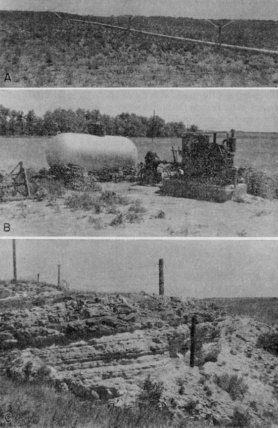
A relatively small amount of ground water is used for irrigation in Graham County. Although several of the wells visited were classified as irrigation wells, only one, well 7-22-10bcb, was used in 1952 (Pl. 5B). This well irrigated several acres of corn, milo, and alfalfa, by a sprinkler system (Pl. 5A). The yield of the well at the time it was first tested was 400 gallons a minute according to C. A. Robben, driller of the well.
Plate 5--A, Irrigating alfalfa by the sprinkler system from well 7-22-10bcb. B, Irrigation well 7-22-10bcb owned by M. E. Worcester. C, Tilted beds in the Smoky Hill chalk member of the Niobrara formation. View in the NW NE sec. 14, T. 8 S., R. 24 W. along U. S. Highway 24.
It is possible that in certain areas in Graham County ground-water supplies sufficient for irrigation can be developed. The two most promising areas for the development of large supplies of ground water are in the valley of South Fork Solomon River and in the northwestern part of the county. The terrace deposits along the river in places are very permeable and would transmit large quantities of water to wells. In addition, the water table is relatively near the surface, which would tend to minimize the cost of drilling and pumping. The thickness and nature of water-bearing terrace deposits differ from place to place and it is advisable to drill test holes to determine the amount of saturated sand and gravel at any locality before an irrigation well is constructed there.
The Ogallala formation in northwestern Graham County contains a large amount of ground water that would be available to irrigation wells. The geologic cross sections shown in Figure 5 indicate that in places the thickness of water-bearing materials is more than 100 feet. Much of this material consists of sand and gravel and would contain much water. However, as in the valley of South Fork Solomon River the drilling of test holes to find the most favorable locations is advisable.
For data concerning the construction and development of irrigation wells the reader is referred to publications by Bennison (1947) and Rohwer (1940).
Chemical Character
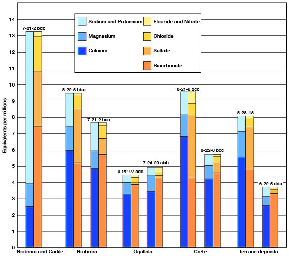
The chemical character of ground water in Graham County is shown by the analyses of water from 21 wells (Tables 3 and 4). Table 3 includes analyses of the municipal water supplies of Bogue and Hill City. Figure 7 shows graphically the chemical character of water from the principal water-bearing formations. The water samples were analyzed by Howard A. Stoltenberg, chemist, in the Water and Sewage Laboratory of the Kansas State Board of Health at Lawrence. The analyses show only the dissolved mineral content and do not indicate the sanitary condition of the water.
Table 4--Summary of the chemical character of the water samples from 21 wells.
| Range in parts per million |
Number of samples | ||||
|---|---|---|---|---|---|
| Terrace deposits |
Crete member of Sanborn formation |
Ogallala formation |
Niobrara formation |
Niobrara formation and/or Carlile shale |
|
| Dissolved solids | |||||
| 200-250 | 1 | ||||
| 251-300 | 8 | ||||
| 301-400 | 1 | 1 | 1 | ||
| 401-500 | 1 | ||||
| 501-600 | 2 | 1 | |||
| 601-700 | 1 | 1 | |||
| 701-800 | 1 | 1 | |||
| 801-887 | 1 | ||||
| Hardness | |||||
| 151-200 | 1 | 3 | 1 | ||
| 201-300 | 1 | 1 | 6 | 1 | |
| 301-400 | 1 | 1 | 1 | ||
| 401-487 | 1 | 1 | 2 | ||
| Calcium | |||||
| 0-50 | 1 | 1 | |||
| 51-100 | 2 | 1 | 8 | 1 | |
| 101-150 | 2 | 2 | 1 | ||
| 151-159 | 2 | ||||
| Sodium | |||||
| 0-50 | 4 | 3 | 9 | 2 | |
| 50-100 | 1 | ||||
| 101-150 | 1 | ||||
| 151-215 | 1 | ||||
| Bicarbonate | |||||
| 0-200 | |||||
| 201-250 | 1 | 5 | |||
| 251-300 | 3 | 3 | 4 | ||
| 301-350 | 3 | ||||
| 351-453 | 1 | 1 | |||
Figure 7--Graphical chemical analyses of samples of water from wells.
Chemical Constituents in Relation to Use
The following discussion of the chemical constituents of ground water has been adopted in part from publications of the U. S. Geological Survey and the State Geological Survey of Kansas.
Dissolved solids--Ground water dissolves some of the rock materials with which it comes in contact. After water has been evaporated, the residue consists of mineral matter, some water of crystallization and some organic material. The most important of these dissolved rock materials in the ground water of Graham County are shown in Table 3. The kind and quantity of dissolved constituents in water determine its suitability for various uses. Water containing less than 500 parts per million of dissolved solids is generally satisfactory for domestic use except for hardness or possibly high iron content. Water containing more than 1,000 parts per million dissolved solids is likely to contain enough of certain constituents to produce a noticeable taste or to be unsuitable in some other respect.
None of the 21 samples of ground water from Graham County contained more than 1,000 parts per million of dissolved solids. The maximum concentration was 887 and the minimum concentration 228 parts per million. Eight samples contained more than 500 parts per million of dissolved solids.
Hardness--The hardness of water is a property that receives considerable attention and it is commonly recognized by the quantity of soap needed to produce a lather and by the curdy precipitate that forms during washing. Calcium and magnesium are the constituents that cause practically all hardness of ordinary water and are the active agents in the formation of the greater part of the scale formed in steam boilers and in other vessels in which water is heated or evaporated.
Hardness is of two types, carbonate and noncarbonate. Carbonate hardness, often called temporary hardness, is caused by calcium and magnesium bicarbonate and can be almost entirely removed by boiling. Noncarbonate or permanent hardness is caused by sulfate, chloride, nitrate, or fluoride of calcium and magnesium and cannot be removed by boiling. In use with soap there is no difference between carbonate and noncarbonate hardness, but in general noncarbonate hardness forms harder scale in steam boilers.
Water having a hardness of less than 50 parts per million is considered as soft. Hardness between 50 and 150 parts per million does not seriously interfere with the use of the water for most purposes but industries that use large amounts of soap, such as laundries, may find it profitable to reduce the hardness by a softening process. Water having a hardness of more than 150 parts per million may be treated by individual users for household use. The use of home water softeners was not observed in Graham County and there are no municipal softening plants in Graham County. Where municipal water supplies are softened the hardness is generally reduced to 100 parts per million or less.
No samples of water from Graham County can be considered as soft, as the minimum hardness was 158 parts per million. The maximum hardness was 487 parts per million. Only three samples contained less than 200 parts per million hardness.
Silica--Silica is a mineral constituent of most ground water. Silica may be deposited with other scale-forming minerals in steam boilers, but otherwise it has no effect on the use of water for most purposes. The silica content of ground water in Graham County ranged from 14 to 42 parts per million.
Iron--If water contains more than 0.2 or 0.3 part per million of iron, the excess may separate out and settle as a reddish sediment when exposed to air. Iron, which may be present in sufficient quantity to give a disagreeable taste, to discolor the water, or to stain plumbing fixtures or fabrics, may be removed from most water by aeration and filtration. However, some water requires additional treatment.
Fluoride--Fluoride is generally present only in small concentration in ground water but it is desirable to know the amount of fluoride in water that is used by children. Fluoride in drinking water has been shown to be associated with the dental defect known as mottled enamel, which may appear on the teeth of children who habitually drink water containing excessive fluoride during the formation of the permanent teeth. Many dental authorities are now in agreement that fluoride in small quantities is a factor in reducing dental caries if the amount does not exceed about 1.5 parts per million. The fluoridation of municipal supplies in areas in the United States where the natural fluoride content of the water supply is low is increasing at the present time.
The fluoride content of water samples from Graham County ranged from 0.2 to 3.2 parts per million. Only two samples contained fluoride in excess of 1 part per million.
Nitrate--The quantity of nitrate in ground water is commonly low, generally less than about 10 parts per million in natural water. Although some nitrate is obtained by ground water from nitrate-bearing rocks and minerals through which it percolates, high nitrate concentrations are thought to be obtained from direct flow of surface water into the well or to the percolation of surface water into the well through the top few feet of the well. Soils, especially during the fall and winter, contain large concentrations of readily soluble nitrate derived from plants or animal waste. Privies, barnyards, and cesspools are also sources of organic nitrogen and may be not only a source of nitrate to wells but a source of harmful bacteria as well.
Nitrate in concentrations of more than 45 parts per million (as NO3) is undesirable because of the possible toxic effect that it may have on the blood circulatory system of infants. (Metzler and Stoltenberg, 1950). This effect, which is known as cyanosis, results when the water habitually consumed by an infant contains a large amount of nitrate. In cyanosis the baby becomes listless and drowsy and the skin becomes blue. If the water supply is not changed in time death may result. Nitrate in drinking water does not cause cyanosis in adults but may be responsible for certain digestive disorders.
Nitrate concentrations in water samples from Graham County ranged from 1.1 to 195 parts per million. Two samples contained 44 parts per million and another had 62, but all others contained considerably less than 45 parts per million nitrate with the exception of the one containing 195.
Water for Irrigation
The suitability of water for irrigation is thought to be dependent principally on the total quantity of dissolved mineral matter and the percentage of sodium. The quantity of chloride may be large enough to affect the use of water and in some areas, boron may be present in sufficient amounts to be harmful to plants. Each factor must be considered with respect to other factors such as soil composition, permeability, drainage, and crop tolerances.
Continuous use of water high in dissolved solids may increase the salinity of the soil, which may ultimately affect the permeability of the soil and disturb plant growth. The total concentration of dissolved constituents may be expressed in terms of parts per million of dissolved solids, of total equivalents per million of anions and cations, or in terms of electrical conductivity. Electrical conductivity is a measure of the ability of inorganic salts in solution to conduct an electrical current, and it is related to the concentration of dissolved solids. Approximate values for electrical conductivity can be obtained by multiplying total equivalents per million of anions or cations by 100, or by dividing dissolved solids in parts per million by 0.7 (Wilcox, 1948, pp. 4-5).
Irrigation water containing a high percentage of sodium may cause dispersion of soil particles and may retard water and air movement through the soil. To find the percentage of sodium the results of the analyses must be reported in equivalents per million. The quantity of sodium in equivalents is divided by the sum of the quantities of calcium, magnesium, sodium, and potassium and the result is expressed as a percentage. In general, water containing more than about 60 percent sodium is undesirable for irrigation use. The classification of water for irrigation is shown in Table 5, and conversion factors to change parts per million to equivalents per million are given in Table 6.
Table 5--Percentage of sodium permissible in several classes of irrigation water (after Wilcox, 1948a, p. 27)
| Classes of water | Percent sodium |
Electrical conductivity (micromhos at 25° C) |
|
|---|---|---|---|
| Rating | Grade | ||
| 1 | Excellent | less than 20 | less than 250 |
| 2 | Good | 20-40 | 250-750 |
| 3 | Permissible | 40-60 | 750-2,000 |
| 4 | Doubtful | 60-80 | 2,000-3,000 |
| 5 | Unsuitable | more than 80 | more than 3,000 |
Table 4--Factors for converting parts per million to equivalents per million.
| Mineral constituent |
Chemical symbol |
Factor |
|---|---|---|
| Calcium | Ca++ | 0.0499 |
| Magnesium | Mg++ | 0.0822 |
| Sodium | Na+ | 0.0435 |
| Potassium | K+ | 0.0256 |
| Carbonate | CO3-- | 0.0333 |
| Bicarbonate | HCO3- | 0.0164 |
| Sulfate | SO4-- | 0.0208 |
| Chloride | Cl- | 0.0282 |
| Fluoride | F-- | 0.0526 |
| Nitrate | NO3-- | 0.0161 |
Water samples from Graham County were not analyzed for boron content. However, water samples from wells in the valley of North Fork Solomon River contained only a small amount of boron (Leonard, 1952, pp. 74, 76) and it is probable that the quantity of boron in ground water in Graham County is insufficient to be harmful to plants.
Only one sample of water from Graham County, from well 7-212bcc1, is thought to be of questionable quality for irrigation. This well, which obtains water from the Niobrara formation and the Carlile shale, contains a high ratio of sodium to other cations as well as moderately high concentration of dissolved solids.
Sanitary Considerations
The analyses of water in Table 3 show only the amount of dissolved mineral matter in the water and do not necessarily indicate its sanitary quality. An abnormal amount of certain mineral constituents, such as chloride or nitrate, however, may indicate pollution of the water.
The entire population of Graham County is dependent on ground water and care should be taken to protect from pollution wells and springs that serve humans. Wells should be located away from possible sources of pollution such as barnyards and privies. If a well must be located near a possible source of pollution, the well should be upslope from such source so that rain water will not run from the source of pollution to the well. Wells should be properly sealed at the top to prevent the direct inflow of surface water. Water samples from two wells in Graham County were rather high in nitrate content. Both wells were poorly sealed at the top and it is thought that nitrate-bearing surface water ran directly into the wells. It is also possible that some harmful bacteria entered the wells at the same time.
Prev Page--Geology || Next Page--Formations
Kansas Geological Survey, Geology
Placed on web Feb. 13, 2009; originally published August 1955.
Comments to webadmin@kgs.ku.edu
The URL for this page is http://www.kgs.ku.edu/General/Geology/Graham/05_gw.html