![]()
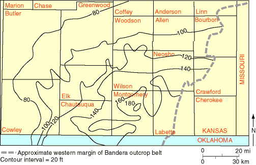
Fig. 6. Lake Neosho-Anna Shale Members isopach map of study area. Thickest portion of the interval is in the southeast, and the interval thins northwestward. Dashed line represents western margin of Bandera outcrop belt. Contour interval = 20 ft (6.1 m).
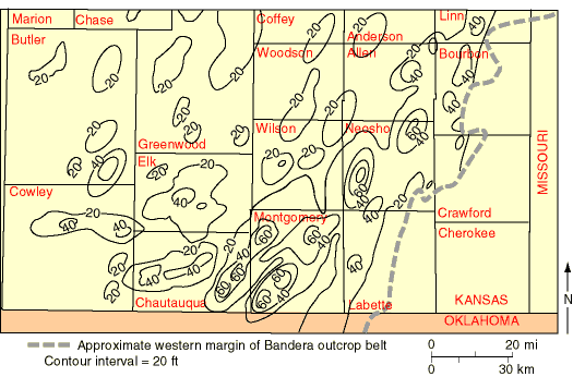
Fig. 7. Sandstone isolith map of the Bandera Shale show concentrations of sandstone units in northeast-southwest orientation, with highest sandstone content in the southeastern portion of study area. Dashed line represents western margin of Bandera outcrop belt. Contour interval = 20 ft (6.1 m).
An isopach map of the Bandera Shale in the northern tier of Oklahoma counties, constructed by A. P. Bennison (personal communication, 1997), shows that the siliciclastic complex in southeastern Kansas thins southward and disappears as the Bandera gives way to the Oologah Limestone. This precludes the possibility of a southern source for siliciclastics. Post-Pennsylvanian erosion northeast of the study area prevents us from evaluating the possibility that siliciclastics were brought into the area from the northeast by southwest-flowing fluvial systems.
A sandstone isolith map of the cumulative thicknesses of sandstone in the Bandera Shale (fig. 7), constructed in the same way as the isopach map, indicates that these sandstones were lenticular and elongate in a northeast-southwest direction. Cumulative thicknesses of sandstone range from 0 ft to 81 ft (0-24.7 m) and include at least 79 counted sandstone beds that were thick enough to be detected by gamma-ray logs. The presence of much thicker sandstone bodies in the southeastern portion of the study area also suggests an easterly source for the sand. As mentioned above, the presence of the Oologah carbonate-dominated platform in east-central Oklahoma during the time of Bandera deposition makes a southerly source for these sands unlikely (Krumme 1981, p. 45). It seems more likely that the Bandera sands entered southeastern Kansas from a more easterly source, perhaps even a northeasterly source.
![]()
Kansas Geological Survey
Web version October 15, 1998
http://www.kgs.ku.edu/Current/1998/brownfield/brownfield4.html
email:lbrosius@kgs.ku.edu