![]()
The gamma-ray and neutron logs available for this study are from 469 wells, which are distributed across an area of about 1,280 square miles (3,315 km2) (fig. 3), averaging one log for every 2.73 sections. The distribution, however, determined in part by the distribution of potential petroleum accumulations, is not even. Another factor influencing data distribution is the fact that much of the petroleum-exploration drilling in the region predates the advent of geophysical well-logging.
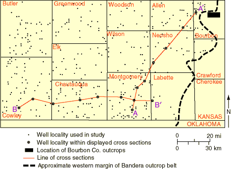
Fig. 3. Distribution of Bourbon County outcrops, well logs, and cross sections used in this study.
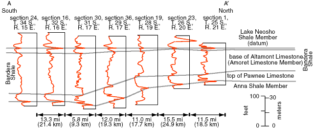
Fig. 4. Gamma-ray logs along cross section A-A', showing a portion of the Marmaton Group between northeastern Allen County and south-central Montgomery County, Kansas, and illustrating the variation in stratigraphy and thickness parallel to the Bandera outcrop belt. See fig. 3 for location of cross section.
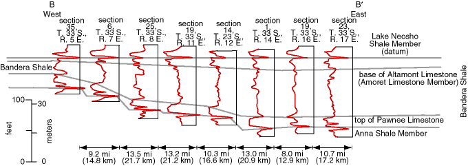
Fig. 5. Gamma-ray logs along cross section B-B', showing a portion of the Marmaton Group between south-central Cowley County and southwestern Labette County, Kansas, and illustrating the variation in stratigraphy and thickness perpendicular to the Bandera outcrop belt. See fig. 3 for location of cross section.
Sandstones were interpreted on each gamma-ray log by constructing a shale baseline and a sandstone baseline representing approximately 100% shale and approximately 100% sandstone, respectively. Deflections to the right of the sandstone baseline that were less than halfway to the shale baseline were considered to be either sandstone or limestone. Other than known limestone units such as the Amoret Limestone Member and Pawnee Limestone, intervals with low gamma counts were interpreted as sandstone.
The sandstones seem to appear at random in the section. No zones could be identified as likely to bear sandstones. Because of the low density of gamma-ray logs, few sandstone units could be carried to an adjacent log, indicating that most sand bodies were stratigraphically discontinuous. For the same reason the shapes of individual sand bodies could not be delineated.
![]()
Kansas Geological Survey
Web version October 15, 1998
http://www.kgs.ku.edu/Current/1998/brownfield/brownfield3.html
email:lbrosius@kgs.ku.edu