Kansas Geological Survey, Current Research in Earth Sciences, Bulletin 241,
part 2
Distribution of the Bandera Shale of the Marmaton Group, Middle Pennsylvanian of Southeastern Kansas--fig. 6
![]()
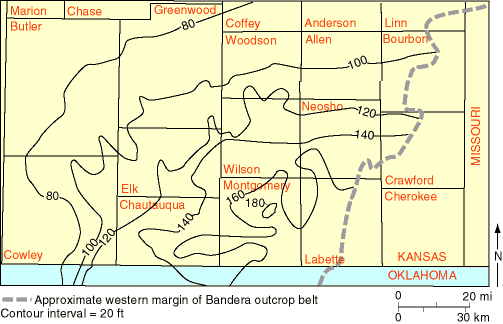
Fig. 6. Lake Neosho-Anna Shale Members isopach map of study area. Thickest portion of the interval is in the southeast, and the interval thins northwestward. Dashed line represents western margin of Bandera outcrop belt. Contour interval = 20 ft (6.1 m).
![]()
Kansas Geological Survey
Web version June 24, 1998
http://www.kgs.ku.edu/Current/1998/brownfield/fig6.html
email:lbrosius@kgs.ku.edu