![]()
Prev Page--Waters of Kansas--Soft Water || Next Page--Bibliography
Part II--The Mineral Waters of Kansas, Arranged and Classified, with Analyses, continued
Chapter XIX--Geological Distribution of Mineral Springs and Wells
by W. R. Crane
The object of this chapter is to give the formations in which the wells and springs discussed in this report occur, together with a statement regarding the probable source of their waters.
It is often difficult, by simply examining the log of a well, to determine which of a series of water-bearing strata is responsible for the supply.
Wells are often sunk several hundred feet below the stratum which is the main source of supply. Such wells, although cased below the water-bearing strata, may still draw their waters from them. It is, therefore, not uncommon to find wells ranging in depth up into the hundreds of feet which are fed by water-sheets only a hundred feet or so below the surface. Such a condition of affairs is rather confusing when considered from the standpoint of the normal arrangement of a well. Many wells in which the water rises a considerable distance after completion illustrate the condition of affairs stated above, which is, however, frequently attributed to hydraulic waters, or those having to a limited degree the artesian principle.
Distributed throughout the different geological areas, wells have been chosen, which, with generalized sections, are taken to illustrate, as nearly as possible, the geological sequence and association of strata passed through, together with the water-bearing strata, which are, or probably are, the source of waters obtained.
The wells and springs are taken up in the order of the distribution of the geological areas, proceeding from the eastward to the westward. This arrangement seems the simplest and most logical, as it groups all of the sources of supply into districts, thus facilitating their discussion; otherwise they would be scattered indiscriminately over the whole area of the state, producing a complexity and confusion of arrangement.
The order of the geological areas chosen for this discussion is as follows: Sub-, Lower and Upper Carboniferous, Permian, Red Beds (or Upper Permian), Cretaceous (which may, for convenience in this connection, be divided into the Dakota and the Upper Cretaceous), and lastly the Tertiary.
Discussion of Wells and Springs by Formation
Sub-Carboniferous
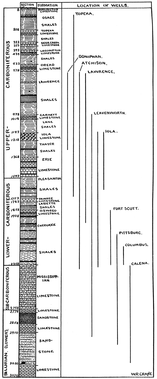
Cherokee County. Ball's mineral well is located near the outcrop of the Sub- and Lower Carboniferous strata. It obtains its waters from the Sub-Carboniferous.
Cave and Chico springs, in the neighborhood of Galena, are located in the Sub-Carboniferous strata and draw their waters from the highly fissured limestone and chert formations, which are so productive of lead and zinc in Kansas and Missouri.
Baxter springs are located just east of the outcrop of the Lower Carboniferous. They have as a source of supply the Sub-Carboniferous.
Lower Carboniferous
Cherokee County. The Columbus well, although situated several miles west of the eastern limit of the Lower Carboniferous, passes through the same and penetrates the Sub-Carboniferous and derives its supply from the same.
Crawford County. The Pittsburg city well was sunk as a prospect hole, but is used at present as a source of water-supply for the city. It passes through the Lower Carboniferous and Sub-Carboniferous and penetrates the Lower Silurian, but probably draws its supply from the Sub-Carboniferous. The Cherokee well also obtains its waters from the Sub-Carboniferous.
The Girard well receives its supply from the lower strata of the Sub-Carboniferous, or from a point near the contact of the Sub-Carboniferous and Lower Silurian.
Bourbon County. The two Bourbon county wells discussed in this report are located at Fort Scott. These wells are known as the artesian and sulfo-magnesian. They both tap the Lower Silurian, from which they draw their waters.
Linn County. The La Cygne iron spring is located in and draws its water from the Lower Carboniferous.
Neosho County. The St. Paul well, although located in the LowerCarboniferous, derives its waters from the Sub-Carboniferous or Lower Silurian, possibly both.
Plate 37--Geological section of upper and lower Carboniferous showing strata that would be pierced by wells. A larger Acrobat PDF version is also available (2.9 MB).
Upper Carboniferous
Labette County. The Mound Valley well probably drains Lower Carboniferous strata.
The Parsons mineral well is situated about on the outcrop of the Upper and Lower Carboniferous strata, but, being shallow, may lie wholly within the Upper Carboniferous.
Montgomery County. The Independence bromo-magnesian . well passes through both Upper and Lower Carboniferous and derives its supply from either the Sub-Carboniferous or Lower Silurian.
The Coffeyville well lies wholly within the Upper Carboniferous strata.
The Coffeyville artesian well taps the Lower Silurian, from which it derives its waters.
The Parkhurst spring has its source in the Upper Carboniferous strata.
Chautauqua County. Chautauqua springs lie within and receive their waters from the Upper Carboniferous.
Wilson County. The Fredonia well extends to the Lower Silurian and probably gets its water from the same.
The Coyville well draws its supply from the Upper or Lower Carboniferous.
The Delaware springs, at Stella, lie wholly within the Upper Carboniferous.
Greenwood County. The Madison sulfur well obtains its waters from the Lower or Sub-Carboniferous.
The Madison salt well has as a source the saliferous shales of the Sub-Carboniferous.
The Eureka mineral well probably lies wholly within the Upper Carboniferous.
Woodson County. The Piqua brine well has as a source of its supply the shales of the Upper and Lower Carboniferous.
The Clarus springs, at Toronto, lie wholly within the Upper Carboniferous.
Allen County. The Iola mineral well probably derives its supply from the Lower Silurian.
Lyon County. Stotler's well draws from the Upper Carboniferous.
Morris County. The Council Grove magnesium well lies within the Upper Carboniferous and probably derives its waters from the same.
Osage County. The Carbondale well lies wholly within the Upper Carboniferous. The Overbrook well also draws from the Upper Carboniferous. The Schoolhouse well is also Upper Carboniferous. The Merrill spring is an Upper Carboniferous product.
Franklin County. Miller's well, at Norwood, probably gets its supply from the Upper Carboniferous.
The Williamsburg well draws its supply from the Upper Carboniferous.
Sylvan springs lie within the Upper Carboniferous.
The California springs are also a product of the Upper Carboniferous.
Douglas County. The Lawrence artesian well draws its supply from either the Sub-Carboniferous or the Lower Silurian, probably the former, or even higher up.
Both Williams and Eudora springs are products of the Upper Carboniferous strata.
Shawnee County. The Boon, Capital and Topeka wells lie within the Upper Carboniferous, which is the source of their supply. Phillips's spring also receives its waters from the Upper Carboniferous strata.
Riley County. The Blasing well, at Manhattan, lies wholly within the Upper Carboniferous.
Leavenworth County. The Kickapoo and Linwood springs both derive their waters from the Upper Carboniferous.
Atchison County. The prospect-hole well, south of Atchison, penetrated the Lower Silurian, but receives its waters both from the Sub- and Lower Carboniferous strata.
The Becker and A. B. C. Laundry wells have, as a source of their waters, the Upper Carboniferous.
The Dixon, McDuff, Arrington and Parker springs obtain their waters from the Upper Carboniferous strata.
Doniphan County. The Eagle springs lie wholly within the Upper Carboniferous strata.
Brown County. The Sun and Sycamore springs both receive their supply from the Upper Carboniferous.
Nemaha County. The Centralia gypsum well draws its supply from the Upper Carboniferous strata, but may be contaminated with the gypsum salts from the Permian strata to the westward.
The Capioma well probably drains Upper Carboniferous strata.
Wyandotte County. The Wyandotte gas well penetrates the . Lower Carboniferous strata, from which it receives its supply.
The Forest Lake well is Upper Carboniferous.
Bonner and Forest Lake springs lie wholly within the Upper Carboniferous formation.
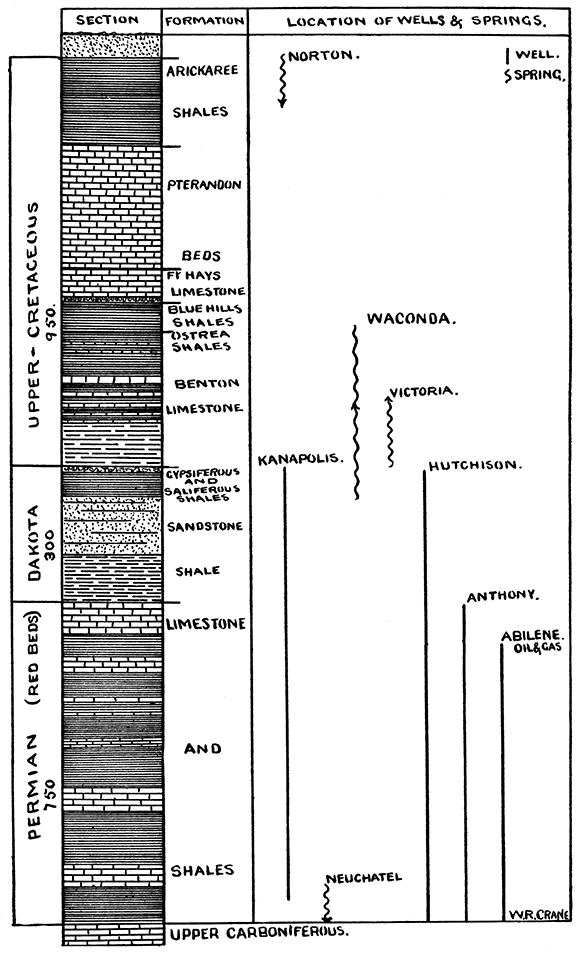
Plate 38--Geological section of Cretaceous, Dakota, and Permian formations, showing strata that would be pierced by wells. A larger Acrobat PDF version is also available (2.4 MB).
Permian
Sumner County. The Conway spring is situated on the outcrop of the Upper and Lower Permian, or the Red Beds and the Permian strata, receiving its waters largely from the former.
Butler County. The Providence mineral well probably draws its waters from the Upper Carboniferous strata.
Harvey County. The Walton mineral well is Permian. Marion County. The Marion mineral well probably has its source in the Upper Carboniferous strata.
The Chingawassa springs are all in the Permian.
Dickinson County. The Abilene Gas and Oil Company's well passes into the Lower Carboniferous strata and probably draws its waters from both the Upper and Lower Carboniferous.
The Abilene sand springs are a product of the Permian.
McPherson County. The Conway springs, located on or near the outcrop of the Permian and Tertiary, probably receive their supply from the Tertiary.
Saline County. The Brookville spring lies on or near the outcrop of the Permian and Tertiary and is fed by the Tertiary.
Geary County. The seven springs near Junction City obtain their waters from the Permian.
Clay County. The Wakefield sulfur well lies Wholly within the Permian.
Pottawatomie County. Hoover's and Moodyville springs have their source in the Permian strata.
The Louisville iron spring is on or near the outcrop of the Permian and Upper Carboniferous and probably receives most of its waters from the Permian.
Nemaha County. The Neuchatel spring is on or near the outcrop of the Permian and Upper Carboniferous strata. It receives its supply largely from the Permian.
Red Beds or Upper Permian
The only water that is obtained from this area is that mentioned at Conway, Sumner county.
Dakota
Barton County. The Great Bend mineral well probably receives its supply from the Dakota strata.
Rice County. The Little River mineral spring is on or near the outcrop of the Dakota and Permian. It obtains its waters from the Dakota.
Cloud County. The sulfur spring at Concordia is on or near the outcrop of the Upper Cretaceous and the Dakota and draws its supply largely from the Upper Cretaceous.
Tertiary
Cowley County. The Arkansas City mineral well receives its supply from either the Permian or the Upper Carboniferous. probably the former.
The Geuda springs are located on or near the outcrop of the Tertiary and Permian strata, and receive their. waters largely from the Tertiary.
Reno County. The Hutchinson brine well, although situated on the Tertiary, draws its supply from the Red Beds or Upper Permian.
Upper Cretaceous
Mitchell County. The Waconda springs are, in some respects, the most interesting natural phenomena known in the state. They are what might be called deep-seated springs, as they draw their supply through a considerable vertical distance from the saliferous shales overlying the Dakota.
Ellis County. The Victoria spring exists in the Upper Cretaceous and obtains its waters from the same.
Russell County. The spring at Fay lies wholly within the Upper Cretaceous.
Jewell County. White Rock and Omio springs receive their waters from the Upper Cretaceous.
The Burr Oak well also drains the Upper Cretaceous strata.
As previously stated, it is a rather difficult task to give anything like an exact geological position to the sources of supply of wells and springs, especially wells, as the depth is, in most cases, not exactly known, and, even if it were, an element of doubt exists.
Springs are usually merely superficial phenomena, while wells, as a rule, especially mineral wells, extend to and often through several unaltered formations, thus drawing their supply from the vadose or deeper-seated superficial waters.
From the depth of many of the wells discussed in this report, it is evident that they are receiving their waters from surface accumulations of eroded and disintegrated formations. They cannot, therefore, be said to exist in any geological formation, but have been located geographically by geological areas.
Prev Page--Waters of Kansas--Soft Water || Next Page--Bibliography
Kansas Geological Survey, Geology
Placed on web April 7, 2017; originally published 1902.
Comments to webadmin@kgs.ku.edu
The URL for this page is http://www.kgs.ku.edu/Publications/Bulletins/Vol7/21_dist.html