![]()
Prev Page—Contents || Next Page—Geology
Introduction
Purpose of Study
The Kansas Geological Survey has long been interested in the strippable coal reserves of southeastern Kansas (Haworth and Crane, 1898; Pierce and Courtier, 1938; Brady and others, 1976), and in the reclamation of the approximately 50,000 acres of land that were surface-mined for coal prior to enactment of the Kansas Mined-Land Conservation and Reclamation Act in January 1969 (Hardy and Camin, 1970; Camin and others, 1971; Camin and Hardy, 1972; Kansas Geological Survey, 1971, 1972). Many questions remain concerning the environmental effects of coal surface-mining and reclamation, particularly with respect to changes in the soil and water. Accordingly, the Kansas Geological Survey implemented this study to obtain comparative data for unmined land and reclaimed and unreclaimed mined land in southeastern Kansas. Another goal of the study was to provide information for the selection of a land-treatment methodology for returning mined land to pasture and grain production. The study was conducted from August 1975 to September 1976 at the Clemens Coal Company Mine 25 site in Crawford County, Kansas (Fig. 1, Pl. 1 ).
Figure 1—Map of Crawford County, Kansas, showing location of Mine 25.
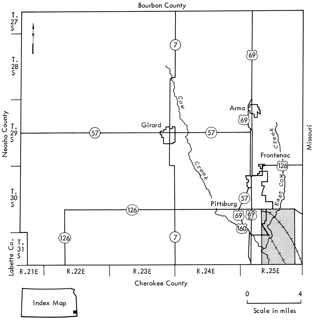
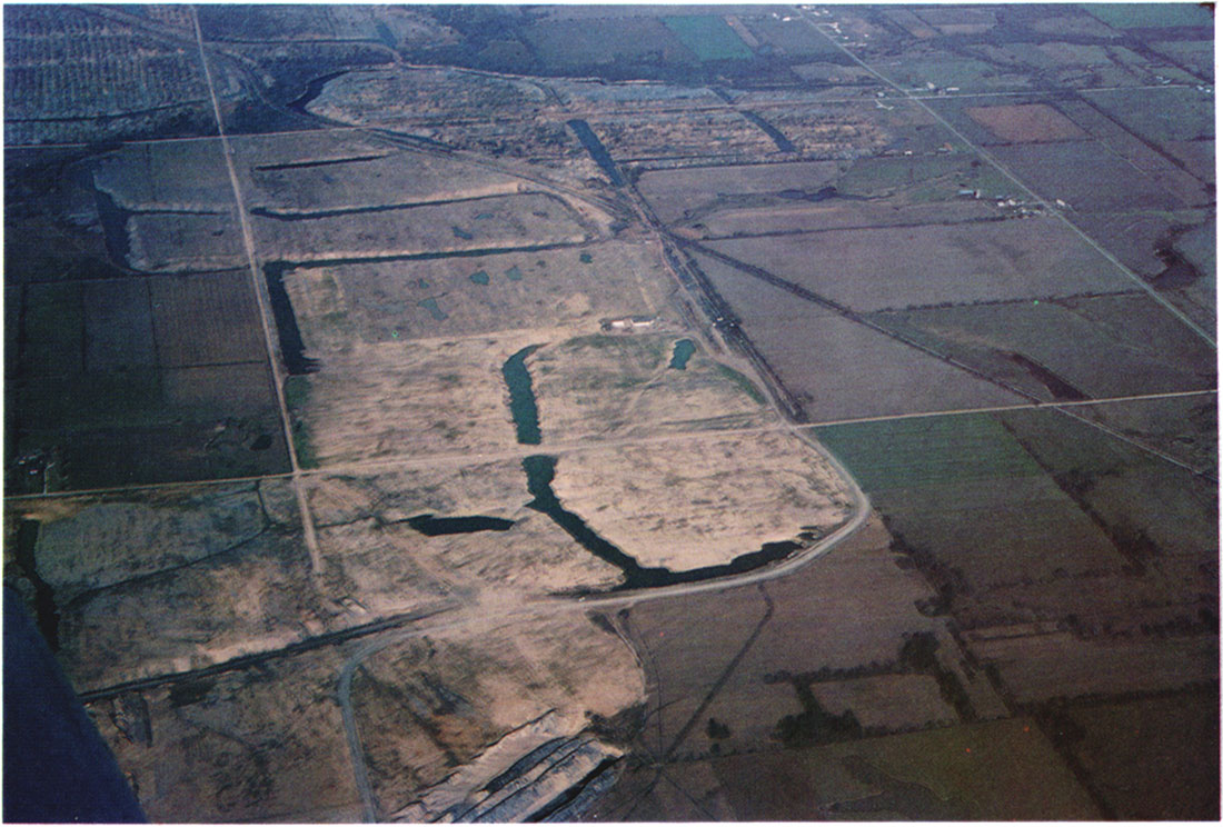
Plate 1—An aerial view from the south showing the mine site, December 1975.
Mining History
Mine 25 is a surface coal mining operation of the Clemens Coal Company of Pittsburg, Kansas. As shown in Figure 2 it encompasses parts of Secs. 26, 27, 34, and 35, T. 30 S., R. 25 E. and parts of Secs. 2, 3, 10, and 11, T. 31 S., R. 25 E., Crawford County, Kansas. The older areas of the mine are located in Secs. 26, 27, 34, and 35, T. 30 S., R. 25 E., and in the N2, NE and the NE, NW of Sec. 2, T. 31 S., R. 25 E. Early attempts at reclamation were performed in the NW (west of the railroad tracks) and the N2, SW of Sec. 2. The results were not satisfactory.
Figure 2—Map of study area.
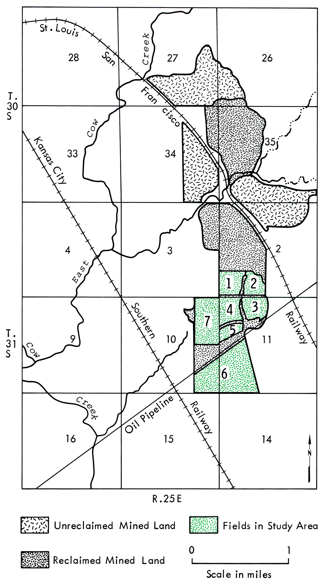
At the time of the initiation of this study in August 1975, the land in the S2, SW of Sec. 2 (Fields 1 and 2) had been reclaimed for 1 year. Leveling of the spoil banks in the NW of Sec. 11, north of the pipeline (Fields 3, 4, and 5), had just been completed. The land in the E2, SE of Sec. 10 and the W2, SW of Sec. 11, south of the pipeline (Field 6), awaited mining. Mining was still in progress on the land in the E2, NE and NE, SE of Sec. 10, north of the pipeline (Field 7).
The mine site afforded an excellent opportunity for comparisons of unmined land and reclaimed and unreclaimed mined land, as well as the opportunity to evaluate a new reclamation method.
Topography and Drainage
The study area is located in the extreme southeast corner of Crawford County on the Cherokee Plain, an erosional surface that rises in slope to the west at an average of 10 feet per mile. The land surface of Crawford County is gently rolling and consists of low hills and broad flat-bottomed valleys with breaks and narrow bluffs adjacent to the larger stream valleys. The southeastern part of this plain, where the study area is located, has the smoothest relief in the county.
Large creeks, but no rivers, drain the area. Cow Creek and East Cow Creek, which flows into Cow Creek, drain the area southward. Cow Creek flows into the Neosho River, which flows into the Arkansas River Basin. East Cow Creek flows intermittently during the summer.
Geology
Bedrock units in the study area are part of the Krebs Formation of the Cherokee Group, Desmoinesian Stage, Middle Pennsylvanian age. Lithologically, the formation is composed mostly of dark-gray to black shales, some sandstones and sandy shale, coal beds, and underclays. Limestone is rare. The coals of interest are the Dry Wood and the Rowe.
Climate
Winter temperatures in this area are relatively mild. The average daily maximum temperature for the coldest month of January is above freezing at 44°F. Temperatures may fall well below freezing and occasionally below zero, but extremely cold weather is usually of short duration. Snowfall is light and averages 13 inches per year. Accumulated snow usually melts within a few days. Summers are warm to hot. Summer temperatures may rise above 100°F, but seldom continue at this extreme for more than a few days. The average daily maximum temperature for the warmest months of July and August is 91°F. The average annual temperature is 57°F.
The study site is in the area of the greatest precipitation in Kansas. Precipitation ranges from 20 to 60 inches per year with the annual average being 40 inches. There is no official dry season, although there are periods of drought. An average of three-fourths of the precipitation occurs during the warmer season from April through October, with May and June being the wettest months. Relative humidity is generally high.
Vegetation
Natural ecological succession in this area resulted in the growth of tall prairie grasses, such as big bluestem and little bluestem, switch grass, Indian grass, and others. Trees are distributed primarily along stream banks and other naturally disturbed areas. The number of species of trees is small and includes American elm, cottonwood, black willow, pin oak, hickory, black walnut, and a few other closely related species.
Settlement of the prairie resulted in the conversion of the prairie to farmland. The main crops currently grown in the county are wheat, corn, sorghum, soybean, and alfalfa. Minor crops are oats, rye, barley, and sweet clover. Tame grass pastures of brome and fescue are common and are used for cattle grazing.
Soils
The moderately acidic soils, which weathered from the shale bedrock or alluvium derived from the shale bedrock in this area, are well developed and relatively deep and have a distinct clay layer in the subsoil formed as a result of downward leaching of clay particles by water. This clay layer impedes deeper downward water movement and hence prevents any substantial subsoil water storage. As a result, drought is a serious hazard on these soils. These soils are well adapted to general farming, provided good management practices are employed.
Water
In this area the Krebs Formation yields small amounts of fresh to moderately saline groundwater to shallow wells for domestic and livestock use. However, water from these wells is greatly diminished during drought periods. Fortunately, deep carbonate and sandstone aquifers of the Arbuckle Group yield large quantities of good-quality water to wells in southeast Crawford County used by municipalities, rural water districts, and industries. Water is also available from Mississippian rocks, but the water is of lesser quality and yields to wells are smaller.
The main sources of surface water in this area are East Cow Creek and its tributaries and water-filled strip pits. Strip pits comprise approximately 6 percent of the approximately 22,000 acres of land surface-mined for coal in Crawford County prior to January 1969. The water quality of many of the tributaries and strip pits has been severely degraded by acid drainage.
Prev Page—Contents || Next Page—Geology
Kansas Geological Survey, Geology
Placed on web Oct. 25, 2018; originally published 1982.
Comments to webadmin@kgs.ku.edu
The URL for this page is http://www.kgs.ku.edu/Publications/Bulletins/MRS7/02_intro.html