![]()
Prev Page--Quality of Water || Next Page--Potential Perennial Yield
Utilization of Water
During the course of the investigation information was obtained on 727 wells in this area (Table 37). All known public-supply wells and most of the industrial wells were visited, and all available data concerning them were obtained. No attempt was made to obtain data on all the domestic and stock wells, and no well inventory was made in some parts of the area (Pl. 5).
Domestic and Stock Supplies
Most of the rural residents and the residents of some of the smaller towns in this area derive their domestic water supplies from drilled and driven wells of small diameter equipped with cylinder or pitcher pumps operated by windmill or by hand. In parts of the area underlain by Permian shale many of the domestic and stock supplies are derived from large-diameter dug wells. Some farm homes have pressure water systems and the wells are equipped with small centrifugal pumps. In the sand hills, an area largely devoted to grazing, livestock is watered from shallow driven wells. In the area underlain by Kiowa shale, livestock supplies are generally derived from drilled wells equipped with windmills, although springs and seeps are important sources of stock water. Most of the domestic and livestock wells yield only a few gallons of water a minute.
The ground waters in this area vary greatly in chemical character, but generally are satisfactory for most domestic uses. Wells that penetrate the Wellington formation and Ninnescah shales yield water that is very hard, and cisterns are used to supply water for some uses in the areas underlain by the Permian rocks.
Industrial Supplies
The industrial uses of ground water in this area include cooling and condensing, air conditioning, manufacture of ice, manufacture of fiber products, water for steam boilers, use in the refining of petroleum products, and meat packing. The suitability of ground water for most industrial uses depends upon the chemical character and temperature of the water. Water used in boilers should be relatively free from foaming and scale-forming constituents. The ground water in parts of this area is not of suitable chemical character for boiler use, and therefore it is necessary to treat the water to reduce the hardness. Large quantities of ground water are used for cooling and air conditioning, and the advantage of using ground water for this purpose is its relatively low, uniform temperature throughout the year. The temperature of most waters sampled ranged from 58 to 60 degrees F.
Wichita area.--Industrial development in Wichita and vicinity has proceeded more rapidly than in other parts of this area, and the greatest use of water for industrial purposes occurs there. In 1942, G. H. Von Hein made a survey of the known industrial wells in and near Wichita; a summary of the utilization of water from these wells is given in Table 23. The quantity of water pumped from private wells for industrial use in 1942 was about 2,400 million gallons, approximately one-half the amount pumped by the City of Wichita from the new well field. Of the total quantity of water pumped, about 80 percent was used for cooling and condensing in refineries, foundries, dairies, and ice plants; about 11 percent was used for air conditioning in office buildings; and about 5 percent was used for laundries in steam boilers and for washing. It is estimated that there are about 3,000 small wells in homes in Wichita from which water is pumped for air conditioning and irrigation of lawns.
Table 23--Utilization of water pumped from private industrial wells in the City of Wichita and vicinity.
| Owner or Company | Annual pumpage (millions of gallons) |
Use | ||
|---|---|---|---|---|
| 1940 | 1941 | 1942 | ||
| Air Reduction Sales Co. | 12 | 12 | 12 | Cooling and condensing |
| Atchison, Topeka, and Santa Fe | 43 | 43 | 43 | Locomotive maintenance |
| American Laundry | 14 | 15 | 18 | Steam boilers and laundry |
| Barnsdall Refining Co. | 100 | 200 | 300 | Cooling and condensing |
| Broadview Hotel | 40 | 40 | 40 | Air conditioning |
| Cardwell Mfg. Co. | 0.2 | 0.6 | 0.5 | Cooling |
| Central Building | 20 | 20 | 20 | Air conditioning |
| Cessna Aircraft Co. | 0.2 | 0.2 | Air conditioning | |
| G.C. Christopher and Sons | 0.2 | 0.2 | 0.2 | Cooling |
| Cities Service Co. | 5 | 5 | 5 | Cooling and condensing |
| City Laundry | 3 | 3 | 3 | Air conditioning |
| Coleman Lamp and Stove Co. | 104 | 104 | 72 | Cooling and condensing |
| Cozine and Galley Co. | 0.3 | Cooling | ||
| Crystal Ice and Fuel Co. | 6 | 6 | 6 | Ice manufacture |
| DeCoursey Creamery Co. | 16 | 7 | 11 | Cooling and washing |
| Dold and Sons Packing Co. | 12 | 12 | 18 | Cooling and washing |
| Drowatsky Greenhouse Co. | 0.5 | Irrigation and cooling | ||
| Dunn-Ostertag Co. | 20 | 20 | 20 | Cooling |
| Eaton Hotel | 17 | 17 | 17 | Air conditioning1 |
| Economy Laundry Co. | 4 | 4 | 5 | Steam boilers and laundry |
| First National Bank Building | 6 | 6 | 6 | Air conditioning |
| Fourth National Bank Building | 17 | 17 | 17 | Air conditioning1 |
| W.W. Grinder Co. | 0.1 | 0.2 | 0.3 | Cooling |
| Allen W. Hinkel Co. | 35 | 35 | 35 | Air conditioning |
| Hyde Park Dairy Co. | 32 | 32 | 36 | Cooling and washing |
| Independent Ice Co. | 7 | 7 | 8 | Cooling and ice manufacture |
| Independent Laundry Co. | 12 | 13 | 17 | Steam boilers and laundry |
| George Innes Co. | 35 | 35 | 35 | Air conditioning |
| Kansas Gas and Electric Co. (office) | 30 | 30 | 30 | Air conditioning1 |
| Kansas Gas and Electric Co. (Wichita station) | 157 | 164 | 175 | Boilers, cooling, condensing |
| Kansas Gas and Electric Co. (Ripley station) | 376 | 376 | 364 | Boilers, cooling, condensing |
| Kansas Milling Co. | 36 | 120 | 129 | Cooling, condensing, washing |
| C. P. Mueller estate | 1 | 1 | 1 | Irrigation and cooling |
| Lassen Hotel | 27 | 27 | 27 | Steam boilers and toilets |
| Lassen Hotel | 13 | 13 | 13 | Air conditioning |
| Linwood Creamery Co. | 25 | 26 | 29 | Cooling and washing |
| Miller Theater | 35 | 35 | 35 | Air conditioning |
| North Wichita Ice Co. | 27 | 28 | 33 | Cooling and ice manufacture |
| Peerless Ice Co. | 43 | 55 | 85 | Cooling and ice manufacture |
| Peerless Laundry Co. | 27 | 29 | 31 | Steam boilers and laundry |
| Public Terminal Elevator Co. | 3 | 3 | 3 | Air conditioning |
| Snyder Ice Cream Co. | 30 | 33 | 36 | Cooling and washing |
| Southwest Cracker Co. | 9 | 9 | 9 | Air conditioning (1) |
| Southwest Laundry | 0.7 | 0.7 | 0.7 | Air conditioning |
| Steffen Ice and Ice Cream Co. | 207 | 226 | 260 | Cooling, condensing, washing |
| Wible Ice Co. | 18 | 18 | 20 | Cooling and ice manufacture |
| Wichita Creamery Co. | 75 | 96 | 122 | Cooling and washing |
| Wichita Hospital | 4 | 8 | 13 | Steam boilers and laundry |
| Wichita Ice Co. | 182 | 184 | 201 | Cooling and ice manufacture |
| Wichita Parts Co. | 0.1 | Cooling | ||
| Wichita Laundry Co. | 11 | 27 | 39 | Steam boilers and laundry |
| 1,897 | 2,163 | 2,401 | ||
| 1 Water returned to ground-water reservoir by means of disposal well | ||||
Many industries in and near Wichita are supplied with water pumped from the municipal wells. Many of the industries so supplied are listed in Table 24 together with the quantity of water used by each company. The total pumpage by the city in 1942 was 4,962.5 million gallons, and the data given in Table 24 show that about one-fourth of this quantity was used by industry. Probably a larger part of the city supply is used industrially, because the quantity of water used by railroads and some smaller industries is not included in this summary. The data in Table 24 show that in 1942 about 40 percent of the water supplied to industry by the city was used in the manufacture of aircraft, and about 30 percent was used by the meat packing industry.
Table 24--Industrial use of water from the Wichita municipal supply (data furnished by the Wichita Water Company).
| Company | Quantity of water used (millions of gallons) | ||
|---|---|---|---|
| 1940 | 1941 | 1942 | |
| Aircraft Products and Supply Co. | 0.2 | ||
| Aircraft Spinning Co. | 0.3 | ||
| Aircraft Welders | 4.5 | ||
| Aero Parts Co. | 0.1 | 3.9 | 10.7 |
| Beardsley and Conchman Machinery Co. | 0.1 | 0.2 | |
| Beech Aircraft Corp. | 9.0 | 47.1 | 110.4 |
| Boeing Airplane Co. | 18.9 | 64.3 | 206.4 |
| Cessna Airplane Co. | 1.1 | 31.0 | 81.7 |
| City Laundry | 22.3 | 22.6 | 24.0 |
| Coffman Hospital | 0.2 | 0.1 | 0.1 |
| Coleman Lamp and Stove Co. | 7.1 | 13.9 | 30.6 |
| G. C. Christopher and Sons | 0.4 | 0.5 | 0.7 |
| Cudahy Packing Co. | 219.1 | 261.4 | 334.3 |
| D. and J. Parts Co. | 0.3 | 0.4 | |
| Davis-Westholt Aircraft Prod. | 4.6 | ||
| DeCoursey Creamery Co. | 40.3 | 36.1 | 23.6 |
| Dold and Sons Packing Co. | 1.2 | 1.2 | 15.2 |
| Dunn-Ostertag Co. | 1.5 | 2.7 | 3.0 |
| G. and H. Tool Mfg. Co. | 0.2 | 1.9 | |
| Hyde Park Dairy | 2.2 | 3.0 | 3.1 |
| Kansas Gas and Electric Co. | 0.6 | 4.5 | 14.9 |
| Kansas Milling Co. | 6.9 | 24.2 | 25.4 |
| Krehbiel Plaster Prod. Co. | 1.2 | ||
| Langdon Tent Co. | 0.3 | 1.7 | |
| Linwood Creamery Co. | 1.6 | ||
| Municipal Airport | 6.6 | 10.3 | 9.5 |
| Peerless Ice Co. | 10.6 | 11.1 | 16.9 |
| Ponca Tent and Awning Co. | 0.1 | 0.1 | 0.1 |
| Service Foundry Co. | 0.2 | 0.3 | 0.3 |
| Snyder Ice Cream Co. | 0.8 | 0.5 | 2.7 |
| Southwest Laundry | 3.1 | 3.9 | 9.5 |
| Southwest Uniform Co. | 0.2 | 0.3 | 0.4 |
| Steffens Ice and Ice Cream Co. | 0.1 | 0.1 | 6.9 |
| Swallow Airplane Co. | 0.5 | 0.8 | 1.1 |
| Unit Tool Assoc. | 1.0 | ||
| Veterans Hospital | 21.8 | 18.7 | 16.6 |
| Watkins, Inc. | 1.6 | 3.4 | 4.9 |
| Wesley Hospital | 21.1 | 23.7 | 30.6 |
| Western Iron and Foundry Co. | 0.9 | 1.3 | 1.7 |
| Wichita Creamery Co. | 2.6 | 1.5 | 2.8 |
| Wichita Ice Co. | 5.1 | 6.9 | 6.3 |
| Wichita School System | 96.4 | 108.7 | 98.8 |
| Wichita Towel Supply Co. | 4.5 | ||
| 502.6 | 709.0 | 1,115.3 | |
Hutchinson area.--Many industrial wells are located in Hutchinson and vicinity, but a complete inventory of these wells was not made. The principal industrial use of water in Hutchinson is air conditioning in stores, hotels, restaurants, office buildings, and private residences. Ground water is used in meat packing plants, mills, foundries, creameries, laundries, and other industries for cooling and washing. Of the many industrial wells in and near Hutchinson, data were collected for only two batteries of wells. One battery of wells is owned and operated by the Central Fibre Products Company located at the NW cor. sec. 8, T. 23 S., R. 5 W. (no. 384), and the other owned and operated by the Atchison, Topeka and Santa Fe Railway Company near the NW cor. SE sec. 4, T. 23 S., R. 5 W. (nos. 382 and 383). These wells are near the south edge of the sand dunes and derive water from the McPherson formation in the Arkansas River valley northeast of Hutchinson.
Four wells (no. 384) supply water to the Central Fibre Products Company for use in the manufacture of fiber board. These wells range in depth from 62 to 68 feet and the depth to static water level is about 22 feet. The wells supply a total of 2,500 to 3,000 gallons a minute to the factory continuously. This quantity of water is approximately equal to the quantity pumped by the Hutchinson Water Company for municipal use. The wells are relatively closely spaced and mutual interference occurs when more than one well is pumping; however, an adequate supply of water is furnished by these wells from a small area. Although the water is hard, it is not nearly so highly mineralized as water from the city-supply wells and is treated by the company before it is used. An analysis of the water from one of these wells is given in Table 13.
Two wells owned by the Atchison, Topeka and Santa Fe Railway Company (nos. 382 and 383) supply water for locomotive maintenance at the railway shops, and in addition supply water to the Cessna Aircraft Company plant and the Hutchinson airport nearby. These wells are similar in construction, are about 40 feet deep, are equipped with 215 gallon-a-minute turbine pumps, and are about 300 feet apart. Estimates of the railway company indicate that the quantity of water pumped is about 7.5 million gallons a month during the summer and about 3.5 million gallons a month throughout the remainder of the year.
McPherson area.--The principal industrial plants using ground water in the McPherson area are oil refineries. Smaller industries in McPherson are supplied with water from the municipal wells. Water is used industrially in the oil fields near McPherson and is derived from small wells on the leases.
The refinery of the Bay Petroleum Corporation is supplied with water from two wells (nos. 83 and 84) located on the plant property. Well 83, at the west side of the refinery grounds, yields about 600 gallons a minute with a drawdown of 56 feet. Well 84, about a quarter of a mile east from well 83, yields about 75 gallons a minute with a drawdown of 75 feet. The difference in the yield of the two wells is due mainly to the thinning of the McPherson formation eastward from the McPherson channel, and also to differences in construction of the wells. In 1944 the refinery was using all the water that could be produced from the two wells.
The refinery of the National Cooperative Refinery Association is supplied with ground water from three wells (nos. 119, 120, and 122) located in the NE sec. 5, T. 20 S., R. 3 W. A fourth well (no. 121), which formerly furnished part of the supply, failed in 1943 owing to deposition of minerals from the ground water in the gravel wall and screen. Well 122 was drilled in 1944, and when tested it yielded 1,100 gallons a minute with a drawdown of 39 feet. The refinery uses about 1,500 gallons of water a minute continuously. The wells penetrate the coarse sand and gravel deposits of the McPherson channel.
Other areas.--In Newton, the Newton Ice Company operates three wells (nos. 269, 270, and 271) having an aggregate yield of 135 gallons a minute. The Halstead Ice Company is supplied with water from well 342, and uses about 3,000 gallons a day. The water pumped from the ice-plant wells is used for cooling condensers. The Kansas Power and Light Company plant near Galva uses about 30,000 gallons of water a day from well 71 in steam boilers and for cooling. The Eldon Gas Company plant is supplied with ground water for cooling purposes from wells 529 and 530.
The Missouri Pacific Railroad Company operates wells 22, 23, and 28 at Marquette and well 590 at Mt. Hope. Water from these wells is treated to reduce the hardness and is used in locomotive boilers. The Chicago, Rock Island, and Pacific Railway Company operates well 73 at Galva and well 144 at Groveland for locomotive use. Data are not available concerning the quantity of water pumped from these railroad wells. The Atchison, Topeka and Santa Fe Railway Company is supplied with water at Newton from the municipal wells, and uses about one-half the total quantity pumped from the Newton we'll field.
Irrigation Supplies
During periods of drought, especially from 1930 to 1936, wells were drilled for irrigation in parts of this area. Most of the irrigation wells have been abandoned since 1937 and only one large pumping plant was operated during the time this investigation was in progress. A few small wells are pumped for the irrigation of small orchards, gardens, lawns, etc., but the aggregate pumpage from these wells is small, even in periods of drought.
Wells 302, 303, and 304 are owned by Mr. Harvey Hensley, Halstead, Kansas, and are used to irrigate alfalfa and corn grown in the SW sec. 22, T. 23 S., R. 2 W. The wells are 48 inches in diameter, are gravel walled, and each yields about 250 gallons a minute with a small drawdown. The wells penetrate the alluvium of the Little Arkansas River valley and the McPherson formation. The Hensley farm has been irrigated for several years, but the wells were not pumped in 1944 and 1945. Pumpage for 1939 is given in Table 25.
Table 25--Pumpage during 1939 from three irrigation wells on the Harvey Hensley farm in the SW sec. 22, T. 23 S., R. 2 W., Harvey County.
| Month | Pumpage in millions of gallons |
|---|---|
| May | 14.4 |
| June | 10.5 |
| July | 3.4 |
| August | None |
| September | 6 |
| October | None |
| November | 6.8 |
| December | 11.3 |
| 52.5 |
Public Supplies
Eighteen cities in the area have public water supplies, all of which are obtained from wells. The average daily consumption by these 18 cities aggregates about 25.2 million gallons of which 71 percent, or about 18 million gallons, is used by the City of Wichita--the largest city in the state.
The supplies are described below in the alphabetical order of the cities.
Buhler
Buhler (population 634) was supplied by the city prior to the spring of 1938 from three drilled wells (258, 259, 261) south of the city, which yielded from 40 to 58 gallons a minute each from fine-grained sand in the alluvium of the Little Arkansas River valley. Because of the small yield and trouble resulting from the fine sand, these wells were abandoned after construction of two new wells (253, 254) situated 4 miles east of the city. The new wells, which have supplied the city since the spring of 1938, are 98 and 88 feet deep, and obtain water from coarse sand of the McPherson formation along the western part of the McPherson channel. When drilled the wells yielded 269 and 201 gallons a minute with drawdowns of 7.7 and 2.0 feet, respectively. The water is forced through a 4-mile pipeline by the electrically driven turbine pumps on the wells and thence directly into the distribution mains, the excess water being stored in an elevated steel tank holding 50,000 gallons. The average water pressure is about 45 pounds to the square inch. Analyses of water from one well (253) in the new well field and one abandoned well in the old well field are given in Table 13. An excessive amount of carbon dioxide in the water formerly caused corrosion of the main, but the water is now treated to remedy this difficulty. The monthly and annual pumpage for the years 1940-44 are given in Table 26. About 10 percent of the water is used by manufacturing establishments.
Table 26--Monthly and annual pumpage of water by the City of Buhler, Kansas, in thousands of gallons.
| 1940 | 1941 | 1942 | 1943 | 1944 | |
|---|---|---|---|---|---|
| January | 1,026.0 | 855.3 | 863.4 | 815.2 | 615 |
| February | 1,026.0 | 887.1 | 820.0 | 738.0 | 640 |
| March | 576.7 | 800.4 | 757.1 | 854.4 | 571 |
| April | 758.9 | 954.8 | 921.4 | 1,162.8 | 621 |
| May | 656.8 | 1,541.2 | 915.1 | 1,156.9 | 781 |
| June | 1,147.2 | 1,454.4 | 1,351.9 | 1,364.1 | 1,906 |
| July | 2,382.6 | 1,950.8 | 1,742.7 | 1563 | 1,658 |
| August | 1,599.6 | 2,093.8 | 1,516.9 | 2127 | 1,588 |
| September | 1,064.4 | 1,366.9 | 1,058.3 | 1096 | 1,042 |
| October | 1,055.8 | 1,131.7 | 903.6 | 710 | 745 |
| November | 599.7 | 1,023.9 | 922.2 | 760 | 672 |
| December | 566.5 | 829.4 | 895.3 | 850 | 673 |
| 11,502.2 | 14,889.7 | 12,667.9 | 13,179.4 | 11,512 |
Burrton
Burrton (population 842) is supplied from five wells in the city near the water tank. Well 365 is a drilled well 52 feet deep and is gravel-packed. It is equipped with a cylinder pump and electric motor, but its yield is not known. The other four (366) are also equipped with cylinder pumps and electric motors, and they yield an aggregate of 75 gallons a minute. The wells obtain water from sand and gravel in the McPherson formation. The pumps on the wells deliver the water directly to the distribution mains, the excess water being stored in an elevated steel tank holding 55,000 gallons. The average pressure is 60 pounds to the square inch, but in the event of a fire the pressure can be increased to 125 pounds by disconnecting the storage tank. The monthly and annual consumption of water based upon readings of consumers' meters is given in Table 27. It is estimated that about 40 percent more water is pumped than is indicated in the table, the loss resulting from leakage, poor meters, and use of water for fighting fires and for flushing streets and sewers. Of the amounts indicated, about 300,000 to 400,000 gallons a month is used by the St. Louis and San Francisco Railroad. The water is hard, as indicated by analysis 365 in Table 13, but is not treated.
Table 27--Monthly and annual consumption of water by the City of Burrton, Kansas, in thousands of gallons.
| 1939 | 1940 | 1941 | 1942 | 1943 | 1944 | |
|---|---|---|---|---|---|---|
| January | 890 | 1,000 | 804 | 980 | 1,095 | 942 |
| February | 943 | 910 | 799 | 899 | 909 | 975 |
| March | 819 | 1,299 | 779 | 857 | 854 | 893 |
| April | 977 | 1,067 | 901 | 918 | 1,033 | 903 |
| May | 1,632 | 894 | 968 | 885 | 1,190 | 890 |
| June | 1,690 | 1,332 | 1,161 | 1,216 | 1,067 | 1,279 |
| July | 2,058 | 2,311 | 1,178 | 1,556 | 1,822 | 1,975 |
| August | 1,195 | 2,151 | 1,901 | 1,254 | 1,618 | 1,483 |
| September | 2,018 | 1,376 | 1,223 | 975 | 1,576 | 1,161 |
| October | 1,429 | 1,202 | 970 | 968 | 1,136 | 975 |
| November | 1,057 | 1,049 | 857 | 841 | 879 | 1,063 |
| December | 886 | 911 | 873 | 884 | 943 | 961 |
| 15,594 | 15,502 | 12,414 | 12,233 | 14,122 | 13,500 |
Canton
Canton (population 796) is supplied by the city from three drilled wells (65-67) situated in the city, which obtain water from sand and gravel in the McPherson formation and in part also from sandstone in the Kiowa shale. Two of the wells are 82 feet deep, are equipped with electrically driven cylinder pumps, and each yields 38 to 40 gallons a minute. One well (67) is 70 feet deep, is equipped with an electrically driven turbine pump, and is reported to yield 60 gallons a minute. The wells discharge directly into the distribution mains, which are connected to an elevated steel storage tank holding 40,000 gallons. An average pressure of 55 pounds to the square inch is maintained. The average monthly consumption is about 1.25 million gallons, about 3 percent of which is used by a railroad. Formerly pumping of an ice-plant well interfered with one of the city supply wells, but the ice plant is no longer in use so that the supply is adequate for the city. The water is very hard, as indicated by analysis 65 in Table 13, but normally the water is not treated except for occasional additions of chloride of lime.
Galva
Galva (population 463) has been supplied by the city since September 1936 from two gravel-packed drilled wells (74, 75) situated in the city, which are 41 and 35 feet deep and obtain water from sand of the McPherson formation. One well (74) yields 123 gallons a minute with a drawdown of about 16 feet, and is pumped only a few hours each day as needed. Well 75, which yields 35 gallons a minute with the same drawdown, is pumped 12 hours daily. Each well is equipped with an electrically driven turbine pump which discharges directly into the distribution mains. Storage is provided by an elevated steel tank holding 50,000 gallons, which maintains pressures ranging from 43 to 50 pounds to the square inch. The average consumption by the inhabitants ranges from 190,000 to 475,000 gallons a month; in addition, the Chicago, Rock Island, and Pacific Railroad purchases 500,000 to 1,000,000 gallons a month from the city. The water is hard, as indicated by analyses 74 and 75 in Table 13, but is not treated.
Halstead
Halstead (population 1,397) is supplied by the city from four gravel-packed drilled wells, all of which obtain water from sand and gravel in the alluvium of the Little Arkansas River valley and the McPherson formation. Two of the wells (339) situated in the northern part of the city are 106 feet deep, are connected to one electrically driven centrifugal pump, and have an aggregate yield of 500 gallons a minute with a drawdown of 14 feet. One well (340) situated near the middle of the city is 110 feet deep, is equipped with a similar pump, and yields 450 gallons a minute with a drawdown of 15 feet. The fourth well (412), which is in the southern part of the city, is 102 feet deep, is equipped with an electrically driven turbine pump, and yields about 175 gallons a minute. The well pumps discharge directly into the mains, storage being provided by an elevated steel tank which holds 50,000 gallons. Normal water pressures range from 40 to 45 pounds to the square inch, but the pressure may be increased to 60 pounds in the event of a fire. The average daily consumption was about 225,000 gallons in 1937 and about 285,000 gallons in 1940 and 1943, all of which was used by the inhabitants, industrial needs being supplied from privately owned wells. The water is hard, as indicated by analyses 339 and 412 in Table 13, but is not treated.
Water levels in wells 339 and 340 were reported to be 18 feet below land surface in August 1937. In May 1941 water levels were 18.54 to 18.74 feet below land surface in these two wells. Periodic measurements begun in June 1943 and continued through 1945 show that non-pumping water levels during this period have ranged from 8.86 to 17.92 feet below land surface in well 339, and from 10.69 to 18.98 feet below land surface in well 340. Thus, it seems that pumping in the Wichita well field has not noticeably affected water levels in the Halstead municipal wells.
Haven
Haven (population 653) is supplied by the city from three gravel-packed drilled wells in and west of the city which tap sand and gravel in the McPherson formation south of the Arkansas River. Well 594 formerly comprised two wells each 55 feet deep connected to one electrically driven centrifugal pump, but prior to 1943 one well was disconnected and abandoned. The aggregate yield from both wells was 300 gallons a minute with a drawdown of 2 feet. Well 595 is 55 feet deep, is equipped with a similar pump, and yields 250 gallons a minute with a drawdown of 10 feet. Well 596, which is 48.3 feet deep, is equipped with an electrically driven turbine pump and yields about 200 gallons a minute. The water is pumped directly into the distribution mains. Storage is provided by an elevated steel tank holding 55,000 gallons, which maintains pressures ranging from 45 to 50 pounds to the square inch. The average daily consumption ranges from less than 60,000 to as much as 100,000 gallons. Although the water is hard, as indicated by analyses 594 in Table 13, it is not treated.
Hesston
Hesston (population 403) is supplied with water by the city. Prior to about 1942 the supply was obtained from two 8-inch drilled wells (221, 222) 88 feet deep that obtained very hard water from shale in the Wellington formation. The wells, which still supply part of the water and are available for emergency use, are equipped with electrically driven turbine pumps and yield 85 and 60 gallons a minute, respectively. During the dry years from 1931 until about 1939 the hardness of the water increased steadily presumably because of reduced recharge from rainfall, and many test holes were put down in an effort to find a supply of softer water from shallow sources. In about 1942 two shallow wells were constructed in the northeastern part of the city which yield softer water and which have since supplied about 90 percent of the water. One well is a 14-inch bored hole 30 feet deep, which obtains water from 5 feet of sand of the McPherson formation just above the shale; the other is a gravel-packed dug well 42 inches in diameter having a 12-inch screen, which also obtains water from the sand just above the shale. Each well is equipped with an electrically driven cylinder pump and each yields 7 gallons a minute. The water from all wells in use is pumped directly into the distribution mains. Storage is provided by an elevated steel tank holding 58,000 gallons, which maintains an average pressure of 50 pounds to the square inch. The average daily consumption ranges in different years from 15,000 to 20,000 gallons a day, all of which is used for domestic purposes. Analyses of water from well 222 and one of the shallow wells (analysis Oa) are given in Table 13. Although the water is hard, it is served without treatment other than occasional chlorination of the water from the shallow wells.
Hutchinson
Hutchinson (population 30,013) is supplied by the privately owned Hutchinson Water Company (formerly by the Kansas Power and Light Company) from eight gravel-walled drilled wells (386-393) situated in different parts of the city (Pl. 5), all of which obtain water from sand and gravel in the alluvium and McPherson formation in the Arkansas River valley. The wells range in depth from 50 to 75 feet, are equipped with electrically driven turbine or centrifugal pumps, and each yields from 750 to 2,000 gallons a minute. The wells discharge directly into the distribution mains and there are no storage facilities, the water pressure being maintained by turning on and off the pumps on part of the wells from time to time. To facilitate this procedure the pumps on six of the wells are controlled from a central station. Because the water from the several wells differs considerably in chemical composition, particularly in chloride content (see analyses 386-393, Table 13), wells yielding water of least desirable quality are kept in reserve for peak loads or standby use. In addition, well 394 used normally for cooling in the electrical generating plant of the Kansas Power and Light Company may be connected to the city mains to help supply water in an emergency. Although the water is hard and somewhat brackish, it is served without treatment other than chlorination. Thus though the present supply is adequate in quantity, an improvement in quality would be highly desirable and could be accomplished by obtaining all or part of the supply from wells that could be drilled near the sand hills northeast of the city. The City of Hutchinson is considering this possibility and a geologic study of the ground-water conditions along the edge of the sand dunes has been made (Williams, 1946). The average daily consumption of water is about 2.75 million gallons; the monthly and annual consumption from 1941 through 1945 are given in Table 28. In addition, considerable ground water is pumped from private wells for cooling and industrial uses.
Table 28--Monthly and annual pumpage of water for the City of Hutchinson, in millions of gallons (data furnished by the Hutchinson Water Company).
| 1941 | 1942 | 1943 | 1944 | 1945 | |
|---|---|---|---|---|---|
| January | 82 | 68 | 74.8 | 81.7 | 71 |
| February | 75.5 | 61.7 | 67.8 | 72.5 | 64.3 |
| March | 68.1 | 68.9 | 77.8 | 73.2 | 73.2 |
| April | 59.5 | 65.4 | 82.4 | 66.3 | 69.5 |
| May | 68.6 | 77.5 | 81.3 | 74.6 | 80.8 |
| June | 78.2 | 70.4 | 91.4 | 95.8 | 81.2 |
| July | 106.6 | 93.6 | 103.4 | 91.3 | 100.2 |
| August | 89.7 | 78 | 114.3 | 90.6 | 100.4 |
| September | 78 | 71.9 | 83.1 | 76.2 | 95.1 |
| October | 68.9 | 71.5 | 81.6 | 64.2 | 80 |
| November | 65.3 | 63.1 | 79.1 | 68.8 | 76.7 |
| December | 64.7 | 68.2 | 84.8 | 71.3 | 82.1 |
| 905.1 | 858.2 | 1021.8 | 926.5 | 974.5 |
Inman
Inman (population 507) is supplied by the city from two 80-foot gravel-packed drilled wells (204) penetrating coarse deposits in the McPherson channel 2 1/2 miles east of the city. Each well is equipped with an electrically driven turbine pump having a capacity of 75 gallons a minute. Although this quantity is adequate, the coarse sand of the McPherson formation here would readily yield larger quantities of water if needed. The well pumps force the water through a 2 1/2-mile pipeline directly into the distribution mains. Storage is provided by an elevated steel tank holding 33,000 gallons, which maintains pressures ranging from 48 to 52 pounds to the square inch. The average daily consumption ranges from about 33,000 gallons a day in winter to about 50,000 gallons a day in summer. Although the water is hard, as indicated by analysis 204 in Table 13, it is not treated.
Lindsborg
Lindsborg (population 1,913) is supplied by the Lindsborg Water and Light Department mainly from three shallow 6-inch drilled wells near the plant, which are connected to one electrically driven centrifugal pump yielding 500 gallons a minute, but in part as needed from two gravel-packed wells (4, 5) 73 and 92 feet deep. All wells are in the city and obtain water from gravel and sand in the alluvium of the Smoky Hill River valley. The two deeper wells are equipped with electrically driven turbine pumps having capacities of 1,000 and 750 gallons a minute, respectively. All well pumps discharge directly into the distribution mains, and normally no storage is provided. A pressure ranging from 60 to 75 pounds to the square inch is maintained. A round concrete reservoir at ground level provides 100,000 gallons of water for use only in emergencies. The average daily consumption is about 300,000 gallons, all of which is used for domestic purposes, industrial needs being supplied from private wells. Although the water is very hard and contains 1.8 parts per million of iron, as indicated by analysis 4 in Table 13, it is not treated.
Marquette
Marquette (population 609) is supplied by the city from three dug wells (24-26) 43 feet deep, which obtain water from alluvial sand and gravel of the Smoky Hill River valley. Two of the wells are 8 feet in diameter and are equipped with electrically driven centrifugal pumps. Well 25 is 20 feet in diameter and has sixteen 16-foot slotted pipes extending laterally from the bottom in order to increase the intake area. It has three centrifugal pumps, two electrically driven and one driven by a gasoline engine for emergency use. The well pumps discharge directly into the mains, the pressure being regulated by three pneumatic tanks and by pneumatically controlled switches on several of the pump motors. Records of the yield of the wells and the average daily consumption are not available. An analysis of water from well 24 is given in Table 13. The water is very hard but is not treated.
McPherson
McPherson (population 7,194) is supplied by the city from four gravel-packed drilled wells (88, 89, 90, 92) situated near the municipal light plant in the western part of the city. The wells are from 137 to 160 feet deep and obtain water from sand and gravel of the McPherson formation near the eastern margin of the McPherson channel. The wells yield from 1,200 to 2,000 gallons a minute each and are among the strongest wells in the entire area. Each well is equipped with an electrically driven turbine pump which discharges directly into the mains. Storage is provided by a concrete stand-pipe holding 840,000 gallons and an elevated steel tank holding 270,000 gallons. The pressure ranges from 80 to 142 pounds to the square inch. The average daily consumption has ranged from as low as 500,000 gallons to as much as 3,500,000 gallons but averages from 800,000 to about 1,000,000 gallons. The monthly and annual pumpage from 1940 through 1945 is given in Table 29. An analysis of water from well 89 is given in Table 13. Although the water is hard, it is served without treatment.
Table 29--Monthly and annual pumpage of water by the City of McPherson, in millions of gallons.
| 1940 | 1941 | 1942 | 1943 | 1944 | 1945 | |
|---|---|---|---|---|---|---|
| January | 23.4 | 22.2 | 21.7 | 20.1 | 24.7 | 26.2 |
| February | 20.4 | 20.7 | 18.6 | 19.8 | 22.4 | 22.1 |
| March | 22.6 | 21.6 | 20.9 | 22.7 | 25.1 | 26.2 |
| April | 23.7 | 23.6 | 20.1 | 24.4 | 23.4 | 23.5 |
| May | 26.3 | 34.6 | 25.4 | 26.2 | 29.3 | 29.3 |
| June | 46.7 | 33.4 | 26.6 | 37.5 | 49.6 | 30.1 |
| July | 75.6 | 51.8 | 46.0 | 49.1 | 43.5 | 44.8 |
| August | 43.5 | 46.3 | 31.6 | 64.5 | 57.3 | 52.9 |
| September | 32.6 | 28.6 | 25.2 | 35.4 | 38.9 | 43.8 |
| October | 33.4 | 21.9 | 23.6 | 36.2 | 28.2 | 29.5 |
| November | 23.5 | 19.5 | 20.9 | 24.0 | 24.9 | 27.6 |
| December | 22.0 | 20.6 | 20.5 | 23.0 | 26.3 | 31.9 |
| 393.7 | 344.8 | 301.1 | 372.9 | 396.6 | 387.9 |
Moundridge
Moundridge (population 864) is supplied by the city from three gravel-packed drilled wells (165, 166, 168) situated from 2 to 2 1/2 miles west of the city, but wells in several different areas were used formerly. At one time a deep well (160) ending in the Wellington formation and a shallow dug well (161) in thin sand of the McPherson formation were put down at the northeastern corner of the city, but the supply was inadequate and the wells were abandoned. Similarly two wells in the southwestern part of the city were used for awhile and later abandoned because the thin deposits of the McPherson formation were inadequate to supply the city's needs. Later prospecting revealed that the McPherson formation becomes thicker toward the west approaching the deep McPherson channel and several wells were put down about 2 miles west of the city. In 1937 two of these wells were in use including well 166 which still supplies most of the water. In 1938 well 167 was put down and used for awhile, but was later abandoned and filled because the yield became greatly reduced. In 1940 wells 165 and 168 were put down and are still in use. Although these are reported to be the most productive wells now in use, well 166 is used to supply most of the water at its present pumping rate of 150 gallons a minute. The three wells now in use are equipped with electrically driven turbine pumps which force the water through a pipeline to the city and thence directly into the distribution mains. Storage is provided by an elevated steel tank holding 30,000 gallons, which maintains an average pressure of about 45 pounds to the square inch. Accurate pumpage figures are not available but the average daily consumption is reported to range from about 40,000 to about 200,000 gallons, all of which is used for domestic purposes. The water is moderately hard, as indicated by analyses 165 and 166 in Table 13, but is not treated.
Mt. Hope
Mt. Hope (population 442) is supplied by the city from two 12-inch drilled wells in the city which obtain water from the McPherson formation in the Arkansas River valley. The system was just put into operation in the summer of 1937, when the entire supply came from one well (589) 74 feet deep, which was tested at 200 gallons a minute with a drawdown of 5 feet. In 1940 or 1941 a well having the same dimensions and yield was put down 150 feet east of well 589. Both wells are equipped with electrically driven turbine pumps which discharge directly into the distribution mains. Storage is provided by an elevated steel tank having a capacity of 50,000 gallons, which maintains a pressure of about 52 pounds to the square inch. The average daily consumption is about 25,000 gallons, all of which is used for domestic purposes. The monthly and annual consumption for 1942, 1943, and 1944 are given in Table 30. The water is very hard, as indicated by analyses 589, 589a, and 589b in Table 13, but it is not treated.
Table 30--Monthly and annual consumption of water by the City of Mt. Hope, in thousands of gallons.
| 1942 | 1943 | 1944 | |
|---|---|---|---|
| January | 501 | 437 | 857 |
| February | 530 | 446 | 551 |
| March | 418 | 574 | 569 |
| April | 504 | 506 | 764 |
| May | 529 | 636 | 821 |
| June | 910 | 601 | 656 |
| July | 1,061 | 1,173 | 919 |
| August | 739 | 1,000 | 996 |
| September | 660 | 750 | 987 |
| October | 464 | 565 | 960 |
| November | 526 | 520 | 937 |
| December | 446 | 521 | 902 |
| 7,288 | 7,729 | 9,919 |
Newton
Newton (population 11,048) is supplied by the city from a well field and pumping station situated along the Atchison, Topeka, and Santa Fe Railway 6 miles west-southwest of the city and just west of Emma Creek. This area is underlain to depths of 125 to 130 feet by the McPherson formation, and a small area of sand dunes southwest of the well field serves as a catchment area for rainfall and greatly adds to recharge in the well field. The city has from time to time put down many test holes and constructed about a dozen wells, some of which have been abandoned. The wells were not abandoned because of any diminution of supply attended by lowering of water levels, but rather because of the inadequate size of some of the earlier wells and because of excessive "sanding" in some wells. Several wells were cleaned out and treated with dry ice with beneficial results. In 1937, when the plant was first visited, four gravel-walled wells (290-293) were in use. They range in depth from 124 to 130 feet and had tested capacities of 240 to 635 gallons a minute, but were pumped at rates of 200 to 310 gallons a minute. Three of the wells were equipped with electrically driven turbine pumps and one had a cylinder pump. Wells 294 and 295, which were added in 1941, are of similar dimensions and yield, and are also equipped with electrically driven turbine pumps. When the plant was revisited in 1943, the supply was being obtained entirely from four of the six active wells. The well pumps deliver the water to a concrete reservoir near the pumping station, which holds one million gallons. From here the water is picked up by one or more of several steam and electrically driven booster pumps and forced through the pipeline to the distribution mains in the city. In the city additional storage is provided by an elevated steel tank holding 600,000 gallons and a concrete reservoir built in 1939 which holds 3,600,000 gallons. Power for pumping the wells and delivering the water to the city is obtained from a municipal steam generating plant at the well field. The daily consumption ranges from about 1.3 to 2 million gallons and averages about 1.5 million gallons, nearly half of which is used by the Atchison, Topeka and Santa Fe Railway Company. The monthly and annual pumpage from 1938 through 1945 are given in Table 31. An analysis of water from well 291 given in Table 13 indicates a total hardness of only 148 parts per million, all of which is carbonate hardness; thus the water is softer than that used by any city in the area except that from the new supply of the City of Wichita. The water is chlorinated but receives no other treatment.
Table 31--Monthly and annual pumpage of water by the City of Newton, in millions of gallons.
| 1938 | 1939 | 1940 | 1941 | 1942 | 1943 | 1944 | 1945 | |
|---|---|---|---|---|---|---|---|---|
| January | 45.8 | 39.6 | 49.1 | 44.7 | 45.3 | 54.6 | 60.0 | 64.9 |
| February | 41.1 | 38.0 | 39.1 | 41.9 | 39.1 | 47.6 | 60.0 | 66.4 |
| March | 45.1 | 42.2 | 42.6 | 43.9 | 43.8 | 56.5 | 53.8 | 60.7 |
| April | 44.2 | 41.7 | 42.8 | 41.3 | 42.9 | 55.7 | 63.1 | 60.1 |
| May | 43.9 | 51.7 | 41.6 | 47.4 | 47.0 | 59.1 | 65.2 | 61.0 |
| June | 49.4 | 54.9 | 59.6 | 46.3 | 50.8 | 58.5 | 62.4 | 64.5 |
| July | 58.2 | 65.9 | 67.9 | 61.7 | 55.6 | 72.0 | 77.7 | 77.1 |
| August | 61.4 | 52.5 | 50.6 | 55.7 | 55.9 | 73.5 | 77.5 | 79.7 |
| September | 49.3 | 59.2 | 45.7 | 48.0 | 52.1 | 57.2 | 75.1 | 70.6 |
| October | 46.8 | 48.9 | 46.2 | 43.9 | 50.8 | 55.0 | 64.7 | 58.9 |
| November | 41.9 | 42.1 | 43.6 | 42.3 | 50.2 | 54.9 | 63.8 | 53.1 |
| December | 42.8 | 40.7 | 43.6 | 46.3 | 54.5 | 60.4 | 69.6 | 60.7 |
| 571.8 | 577.5 | 572.5 | 563.9 | 587.9 | 705.0 | 792.9 | 777.7 |
Periodic water-level measurements are being made in an abandoned well in the Newton well field. This well (known as the Cook well) is affected at all times by the pumping of the city-supply wells. In August 1938 the depth to water level was 46.17 feet below land surface, and was 47.42 feet below land surface on June 18, 1943 when monthly measurements were begun. During the 3-year period of record, the highest water level was 39.31 feet below land surface in January 1946, and the lowest measurement was 58.29 feet in August 1946.
Sedgwick
Sedgwick (population 738) is supplied by the city from a battery of six similar gravel-packed drilled wells (410) situated 5 to 10 feet apart and connected to one electrically driven cylinder pump. The wells are 46 to 50 feet deep and obtain water from sand in the alluvium. Another similar well was constructed in July 1945. The aggregate yield of the six wells is 250 to 300 gallons a minute. The water is pumped directly into the distribution mains, the excess being stored in an elevated steel tank holding 55,000 gallons. The average daily consumption is about 120,000 gallons, all of which is used for domestic purposes. The water is hard, as indicated by analyses 410, 410a, and 410b in Table 13, but is not treated.
Valley Center
Valley Center (population 700) is supplied by the city principally from two gravel-packed drilled wells (564, 565) situated in the western part of the city. The first well (555) was put down in 1929 but was abandoned in 1934 because of corrosion of the screen. Well 556 was put down in 1934 but is no longer in use because the water later developed a bad taste. Wells 564 and 565, which were put down in 1937 and 1938, respectively, are 52 and 51 feet deep and both obtain water from gravel in the alluvium. Each well is equipped with an electrically driven turbine pump and yields about 250 gallons a minute with a drawdown of about 4 feet. The well pumps deliver the water directly into the distribution mains, storage being provided by an elevated steel tank holding 30,000 gallons. The maximum pressure is about 60 pounds to the square inch. The average daily consumption is about 100,000 gallons and the maximum quantity pumped in one day (in 1942) was 180,000 gallons. The water is hard, as indicated by analysis 564 in Table 13, but is not treated.
Wichita
(Estimated 1944 population: Wichita 183,000, greater Wichita 204,000.)
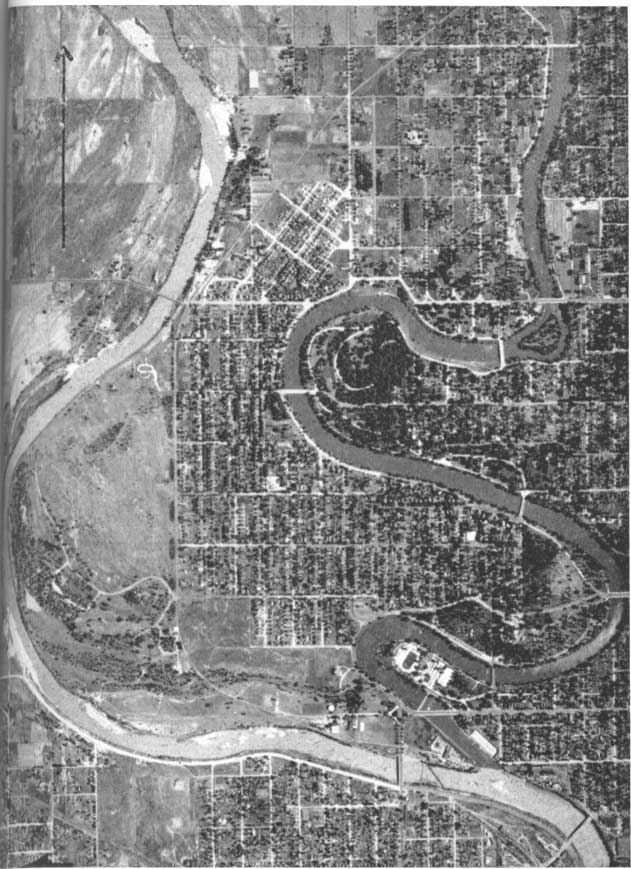
Supply prior to September 1, 1940.--From 1882 until September 1, 1940 the City of Wichita was supplied with water by the privately owned Wichita Water Company, a subsidiary of the American Water Works and Electric Company. The water was obtained mainly from a group of wells situated on what is known as Water Works Island, which is a peninsula lying between the Arkansas and Little Arkansas rivers just above their confluence and about 1 mile west of the business district (Pl. 32).
Plate 32--Aerial photograph showing the confluence of Arkansas and Little Arkansas rivers in the City of Wichita. Note submerged sand bar in Little Arkansas River. Arrow points north and is about 0.5 mile long. U.S. Department of Agriculture photograph.
As the need for water increased additional wells were added until ultimately 56 wells were in use. The locations of all but three of these are shown in Figure 30 (see also Pl. 5). Forty-two of the wells are 8 inches in diameter, and all are connected to a suction pump in the pumping station. In addition there are 11 usable gravel-walled wells (671-673, 675-682) on Water Works Island, one similar well (670) situated just east of the Little Arkansas River on Riverview Drive north of Central, and two similar wells (665, 666) just east of the Little Arkansas River and south of Twenty-first Street (Pl. 5). These 14 wells are equipped with electrically driven turbine pumps and most of them yield from 1,000 to 1,660 gallons a minute but two yield 750 and 830 gallons a minute. All of the wells obtain water from permeable sand and gravel in the alluvium.
Figure 30--Map of Water Works Island showing the location of the pumping station, reservoir, and principal wells of the Wichita Water Company. Wells of small diameter pumped by suction represented by open circles; gravel-packed wells equipped with turbine pumps represented by numbered red squares, numbers of wells corresponding to those in Table 37 and Plate 5; observation well 674 represented by open red square.
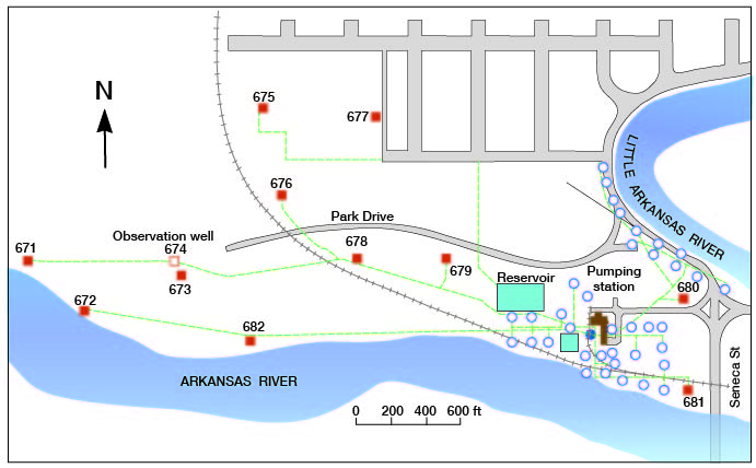
An abandoned gravel-walled well (674) on Water Works Island is equipped with an automatic water-stage recorder and has been used as an observation well (Pl. 28B) since 1938. The record obtained shows an abrupt recovery in water level in the well following the cessation of pumping in the well field on September 1, 1940 (Fig. 22). It also shows that the water level in the well is directly affected by changes of water level in the river; the water level rose rapidly when an ice jam was formed in the river (Fig. 21) and declined somewhat less rapidly when the jam was broken.
The water from the wells on Water Works Island was discharged into two covered square concrete reservoirs (Fig. 30) which hold 3.3 million and 1.0 million gallons, from which it was pumped directly into the distribution mains by several large-capacity cylinder and centrifugal pumps. The water from wells 665, 666, and 670 was pumped from the wells directly into the mains.
The average daily consumption from the old well field ranged from 10 to 12 million gallons, but during hot, dry summers it was as high as 21.5 million gallons.
Though this supply had been adequate in quantity, the water was of very poor quality because of its high hardness and high chloride content which rendered the water unpalatable and otherwise objectionable for domestic and industrial use. The water was served without treatment other than chlorination at some of the wells. Treatment for reduction of hardness would have been very costly and the chloride could not have been removed economically by treatment. The waters from the individual wells differ considerably in chemical quality; in general, the wells nearest the Arkansas River yield the water of poorest quality. For this reason, wells 665, 666, and 670, which are farthest from the river, were used as much as possible. Analyses 671 and 677 (Table 13) indicate the quality of water obtained from two of the wells but do not indicate the average quality of the water from all wells or the entire well field. The average chemical character is indicated by analyses RRR-WWW (Table 13), and a comparison of waters from the old and new well fields is given in Table 33 (Fig. 29).
The old well field is kept in readiness for emergency use, and has been used for brief periods following breaks in the new pipeline and other interruptions.
History of development of new supply.--Because of the poor quality of the water obtained from the old well field, several attempts were made to find and develop a better supply.
In 1924 the City Commission requested the American Water Works and Electric Company to make an investigation of the water supply and the possibility of supplying water of better quality to the consumers served by the Wichita Water Company. In the report to the city prepared by G. W. Biggs, Jr., chief engineer, and C. E. Trowbridge, chief chemist and sanitary engineer, three possible solutions to the problem were presented (letter of August 21, 1924 to the city manager): (1) development of an underground supply from the "Equus beds," lying (within 10 miles) north of Wichita; (2) softening the present supply; and (3) development of a water supply from the Little Arkansas River, augmented during peak loads from the then existing wells, and softening the water to a hardness of 100 parts per million. Plan 3 was recommended as the most practicable solution.
In the same year the State Geological Survey of Kansas also was asked to give its assistance. In an undated typewritten report to the city prepared in the fall of 1924, R. C. Moore, state geologist, was in general agreement with the conclusions reached in the report by Biggs and Trowbridge in recommending that the supply be obtained from the Little Arkansas River augmented by water from the old well field, and that the water be treated. Moore also pointed out the possibility of obtaining water of good quality from wells in the vicinity of Big Slough and Cowskin creeks, about 6 miles west from Wichita. These recommendations were not carried out, however.
In 1930 the Wichita Water Company put down 15 test holes along the Little Arkansas River as far north as Valley Center, and on the basis of these tests constructed two gravel-walled wells about half a mile apart on the Updegraff farm northwest of Valley Center. The wells were completed in October 1930 and were pumped at rates of about 630 gallons a minute until sometime during the winter of 1931. Periodic water-level measurements were made in the wells and in a series of driven observation wells. Because of the considerable drawdown in water level that occurred during the pumping test, the wells were abandoned and no further thought was given to the possibility of obtaining the supply from the Valley Center area. The north well (557) has been used since 1937 as a recorder-observation well (Fig. 16).
In 1937 the Wichita Water Company put down several test holes in the Arkansas River valley east of Bentley in an effort to test the possibilities of obtaining a supply from wells in that area. The tests indicated that wells in this area would yield large quantities of water, but the water was of poor quality in most of the test holes because of the proximity to the Arkansas River, and this area was also abandoned as a possible source of supply. One of these test wells (568) has been used as a recorder-observation well since 1937.
The investigation begun in 1938 by the State and Federal Geological Surveys, the State Board of Health, and the City of Wichita, which ultimately led to the development of the present municipal well field, has been described. The location of the new well field (Pl. 28) was the result of a compromise in order to obtain the maximum quantity of water of the best possible quality, and with the least danger of contamination by saltwater. Owing to the high salinity of the ground water in a narrow belt parallel to the Arkansas River it was necessary to stay as far from this river as possible. It was also necessary to keep as far as possible from the Burrton oil field, just west of Burrton, in order to lessen the danger of contamination from oil-field brines. The supply thus developed is described below.
New supply--The new municipal water-supply system of the City of Wichita was placed in operation on September 1, 1940. The water is obtained from 25 gravel-walled wells situated in Harvey County, southwest of Halstead (Pl. 28). The minimum spacing between wells is half a mile and the over-all length of the well field is 9 miles. A few of the shallower wells were excavated by means of an orange-peel bucket (Pl. 26B), but the deeper wells were drilled by the hydraulic rotary method. The wells were drilled to a minimum diameter at the bottom of 30 inches, and the well screens and blank casings have an inside diameter of 18 inches. All blank casing and 23 of the 25 screens are made of 3-gauge pure ingot iron; two of the screens, however, are made of cast iron. The annular spaces around the casings and screens are filled entirely to the top with screened gravel. The wells are described in Table 37 and other pertinent data are given in Table 32.
Table 32--Records of new Wichita municipal supply wells (Courtesy Black and Veatch, consulting engineers).
| Well No., Pls. 5 and 28, Table 37 |
City No. | Depth (feet) |
Total screen length (feet) |
Initial depth to water level |
Initial 36-hour pumping test | ||
|---|---|---|---|---|---|---|---|
| Yield (gallons a minute) |
Drawdown (feet) |
Specific capacity (gallons a minute per foot of drawdown) | |||||
| 311 | 1 | 221.8 | 60 | 20.6 | 1,560 | 60.9 | 25.6 |
| 314 | 2 | 234.0 | 60 | 20.3 | 1,400 | 64.0 | 21.9 |
| 317 | 3 | 237.8 | 65 | 25.2 | 2,000 | 62.6 | 31.9 |
| 322 | 4 | 234.0 | 60 | 25.2 | 910 | 63.8 | 14.3 |
| 330 | 5 | 237.5 | 65 | 20.4 | 1,420 | 66.1 | 21.5 |
| 333 | 6 | 257.3 | 60 | 24.2 | 2,040 | 64.6 | 31.6 |
| 415 | 8 | 257.5 | 65 | 20.1 | 1,570 | 73.2 | 21.4 |
| 419 | 10 | 259.3 | 65 | 14.4 | 1,800 | 73.9 | 24.4 |
| 423 | 9 | 248.5 | 65 | 13.5 | 2,010 | 47.7 | 42.1 |
| 426 | 20 | 248.0 | 60 | 13.2 | 2,010 | 60.1 | 33.4 |
| 429 | 11 | 227.5 | 55 | 9.7 | 1,980 | 35.2 | 56.2 |
| 433 | 15 | 192.6 | 55 | 14.9 | 2,030 | 37.4 | 54.3 |
| 436 | 12 | 236.0 | 60 | 15.2 | 1,960 | 45.3 | 43.3 |
| 440 | 16 | 193.4 | 60 | 13.4 | 2,000 | 49.4 | 40.5 |
| 450 | 14 | 102.2 | 35 | 10.7 | 1,570 | 28.4 | 55.3 |
| 452 | 17 | 185.5 | 50 | 9.3 | 2,010 | 51.2 | 39.3 |
| 455 | 7 | 122.0 | 60 | 12.0 | 2,030 | 14.4 | 141.0 |
| 459 | 13 | 244.8 | 60 | 11.2 | 2,010 | 42.3 | 47.5 |
| 465 | 18 | 157.8 | 40 | 11.1 | 1,860 | 43.7 | 42.6 |
| 473 | 21 | 79.5 | 30 | 12.6 | 1,870 | 20.9 | 89.4 |
| 476 | 22 | 81.6 | 30 | 14.3 | 710 | 20.8 | 34.1 |
| 479 | 19 | 145.0 | 14.1 | 1,280 | 40.0 | 32.0 | |
| 487 | 23 | 204.5 | 55 | 13.5 | 1,870 | 56.1 | 33.3 |
| 491 | 24 | 97.0 | 30 | 13.7 | 1,480 | 26.1 | 56.7 |
| 494 | 25 | 189.0 | 55 | 10.5 | 1,980 | 43.2 | 45.8 |
The wells are pumped by electrically driven turbine pumps ranging in capacity from 500 to 1,000 gallons a minute, and the water discharges into the 14-inch collecting lines and thence into the main 48-inch supply line. The 25 wells are not all pumped at the same time but are pumped in groups of about 8 or 10 while the remaining wells are idle. Pumping is shifted from one group to another at intervals of several weeks. The supply pipeline extending from the 25 wells to the treatment plant at the city comprises 33 miles of cast iron pipe, most of which is 48 inches in diameter, and has a gravity capacity of 32 million gallons a day. The pump on each well is individually controlled from either the treatment plant at Wichita or from the control station in the well field by means of an electrical supervisory control system. Each supply well is equipped for periodic measurement of water level and has a pair of observation wells at distances of 100 and 500 feet from it.
In the modern treatment plant, which is situated near the pumping station of the Wichita Water Company, the water is treated for removal of iron and manganese and for reduction in hardness. Analyses of water from the 25 supply wells are given in Table 13 (Same numbers as in Table 32; see, also, analysis SS) and a comparison between the chemical quality of the water formerly supplied by the Wichita Water Company and the raw and treated water from the new municipal wells is given in Table 33. This comparison and the analyses in Table 13 show that the water now supplied to the City of Wichita is softer and less mineralized than that used by any other city in the area.
Table 33--Comparison of quality of water formerly supplied to the City of Wichita with that being supplied from the new well field at end of first year's operation (from report of August 31, 1941, by M. E. Rogers, water-supply superintendent; analyses by Robert H. Hess, city chemist).
| Constituent | Parts per million | ||
|---|---|---|---|
| Old well field | New well field | ||
| Raw water | Treated water | ||
| Iron (Fe) | 0.10 | 0.96 | 0.00 |
| Manganese (Mn) | Trace | 0.28 | 0.01 |
| Calcium (Ca) | 134 | 50 | 37 |
| Magnesium (Mg) | 29 | 8.7 | 8.5 |
| Sodium and Potassium (Na + K) | 260-450 | 50 | 50 |
| Carbonate (CO3) | 0 | 0 | 4 |
| Bicarbonate (HCO3) | 232 | 251 | 206 |
| Sulfate (SO4) | 235 | 29 | 29 |
| Chloride (Cl) | 400-700 | 23 | 23 |
| Carbon dioxide (CO2) | 35 | 26 | 0 |
| Oxygen (O2) | 0 | 0 | 8.2 |
| Total dissolved solids | 1,600 | 303 | 280 |
| Total hardness | 450 | 160 | 128 |
| Carbonate hardness (Calculated as CaCO3) | 190 | 160 | 128 |
| Non-carbonate hardness | 259 | 0 | 0 |
| Total alkalinity | 190 | 206 | 172 |
| Excess alkalinity | 0 | 46 | 44 |
| 6.9-7.1 | 7.15 | 8.2 | |
After passing through the sand filters in the treatment plant the water flows into two underground storage basins holding an aggregate of more than 4 million gallons. From these basins the water is conducted to the nearby reservoir and pumping station of the Wichita Water Company whence it is distributed through the city mains. The Wichita Water Company collects the water bills, pays the City of Wichita for pumping, treating, and delivering the water to its pumping station, and maintains its old well field for emergency use. The monthly pumpage from the new well field from September 1, 1940 through 1945 is given in Table 34 and is shown in Figures 24, 25, and 26.
Table 34--Monthly and annual pumpage of water from the new Wichita municipal well field, in millions of gallons.
| 1940 | 1941 | 1942 | 1943 | 1944 | 1945 | |
|---|---|---|---|---|---|---|
| January | 277.4 | 317.9 | 393.4 | 542.2 | 505.0 | |
| February | 247.9 | 349.9 | 388.5 | 493.2 | 444.3 | |
| March | 269.7 | 337.5 | 422.6 | 516.3 | 514.8 | |
| April | 320.6 | 361.1 | 484.7 | 534.3 | 476.0 | |
| May | 336.4 | 381.5 | 495.9 | 570.1 | 578.5 | |
| June | 415.4 | 444.1 | 543.3 | 597.2 | 566.9 | |
| July | 459.6 | 459.9 | 653.6 | 629.7 | 654.6 | |
| August | 483.3 | 625.9 | 643.3 | 652.9 | 665.7 | |
| September | 297.6 | 447.5 | 455.7 | 555.1 | 586.1 | 570.4 |
| October | 378.7 | 336.0 | 435.8 | 539.2 | 524.7 | 552.4 |
| November | 316.6 | 345.7 | 384.6 | 517.8 | 496.5 | 479.5 |
| December | 286.4 | 320.9 | 408.6 | 510.4 | 498.3 | 490.2 |
| 1279.3 | 4260.4 | 4962.5 | 6149.8 | 6641.5 | 6498.3 |
The considerable increase in water consumption attending the wartime increase in population and industrial activity is clearly indicated in the table. In addition, a considerable quantity of water is pumped from private wells in the city for air-conditioning and industrial use.
In order to help safeguard the chemical quality of water obtained from the 25 supply wells, 10 pairs of 1 1/4-inch chloride-observation wells were put down along the eastern margin of the Burrton oil field, which lies from about 5 to 12 miles west of the supply wells. One of each pair of wells extends to a point just above the Permian bedrock at depths of 66 to 255 feet; the other well of each pair extends about half-way to bedrock. Samples of water are pumped quarterly from these wells and also from about 30 private shallow wells, and the chloride content of the samples is determined in order to detect any significant increase in chloride content far in advance of the time any body of brackish or salty water might possibly reach the municipal well field. The locations of these chloride observation wells are shown on Plate 28, and the chloride content of ground waters in and near the Burrton oil field is shown on Plate 29. By January 1946 there had been no significant increase in chloride concentration in the deep chloride-observation wells, and only a slight increase in three of the shallow wells near the Arkansas River.
The effect of pumping the 25 supply wells on the water table and other matters pertaining to the perennial yield of the Wichita well-field area are discussed in the next section.
Prev Page--Quality of Water || Next Page--Potential Perennial Yield
Kansas Geological Survey, South-central Kansas
Comments to webadmin@kgs.ku.edu
Web version April 2005. Original publication date July 1949.
URL=http://www.kgs.ku.edu/Publications/Bulletins/79/15_util.html