Kansas Geological Survey, Bulletin 52, Part 3, originally published in 1944
Prev Page--Introduction, Stratigraphy, Mining, Production
For the purpose of this report all parts of the coal bed 6 inches or more thick, regardless of the thickness and character of overburden, are considered coal reserves. The lower limit of 6 inches was selected because coal of this thickness was formerly mined in the now abandoned Sycamore mining district north of Independence in Montgomery County. It is undoubtedly true that the part of this reserve included in beds near the lower limit of thickness cannot be mined economically at the present time or in the immediate future because of competition from thicker coal beds and other types of fuel. These thin beds may be mined, however, on a local basis for the miner's winter fuel supply; at some time in the future they may be counted as a commercial reserve.
Field investigations show the Thayer coal to be essentially a continuous deposit throughout the area of Chanute shale outcrop except where erosion has removed the coal. In the region of outcrop the coal extends beneath the area capped by the overlying Iola limestone. In estimating the Thayer coal reserves, the following procedure was followed: (1) all territory between outcrops where the coal is 6 inches or more thick was considered; (2) between outcrops, thicknesses of coal were computed on the assumption of a uniform thickness gradient and plotted as such on a map; (3) lines of equal coal thicknesses were drawn through places where the coal is 6, 9, 12, and 18 inches thick; (4) where practicable, reserves were computed for areas where the coal has a known or computed thickness of 6 to 9 inches, 9 to 12 inches, 12 to 18 inches, and more than 18 inches; (5) in computing the tonnage for the various coal areas as classified in item 4, the minimum thickness of the coal was used; and (6) the assumption was made that a Thayer coal-bearing acre contains 125 tons of coal per inch of coal bed.
The amount of coal that may be recovered from a coal-bearing acre will depend upon the type of mining employed. Because of the shallow depth of the coal beneath the surface, 60 feet or less in the area studied, most of the Thayer coal which can be produced will probably be mined by the stripping method. The effect of the type and character of the overburden on possible future stripping operations was not studied.
The total Thayer coal reserves are estimated at 36,822,750 tons. Of this amount, 1,078,500 tons occur in the bed where it is 6 to 9 inches thick; 13,252,500 tons are coals 9 to 12 inches thick; 14,893,500 tons are coals 12 to 18 inches thick; and 7,598,250 tons are coals 18 inches or more thick. A summary of the estimated Thayer coal reserves by mining districts is presented in table 9.
Table 9--Estimates of Thayer coal reserves.
| Mining district |
County | 6-9 inches | 9-12 inches | 12-18 inches | 18+ inches | Total for mining district or county |
|||||
|---|---|---|---|---|---|---|---|---|---|---|---|
| Acres | Tons | Acres | Tons | Acres | Tons | Acres | Tons | Acres | Tons | ||
| Blue Mound | Linn | 50 | 37,500 | 241 | 271,125 | 291 | 308,625 | ||||
| Chetopa, Thayer, Coal Hollow, Dry Creek |
Neosho, Wilson |
3,190 | 478,500 | 6,349 | 7,142,625 | 7,247 | 10,870,500 | 3,302 | 7,429,500 | 20,088 | 25,921,125 |
| Prior, Choteau, Irish | Montgomery | 575 | 431,250 | 1,188 | 1,336,500 | 838 | 1,257,000 | 2,601 | 3,024,750 | ||
| Sycamore | Montgomery | 175 | 131,250 | 1,063 | 1,195,875 | 1,238 | 1,327,125 | ||||
| Independence | Montgomery | 788 | 886,500 | 788 | 886,500 | ||||||
| Independence, South | Montgomery | 100 | 150,000 | 75 | 168,750 | 175 | 318,750 | ||||
| North Coal creek | Montgomery | 163 | 183,375 | 163 | 183,375 | ||||||
| Coal Creek | Montgomery | 625 | 937,500 | 625 | 937,500 | ||||||
| Coal, Clear, Bluff | Montgomery | 1,888 | 2,124,000 | 1,888 | 2,124,000 | ||||||
| Bluff | Montgomery | 350 | 525,000 | 350 | 525,000 | ||||||
| Spring, Fawn | Montgomery | 100 | 112,500 | 769 | 1,153,500 | 869 | 1,266,000 | ||||
| Totals | 3,990 | 1,078,500 | 11,780 | 13,252,500 | 9,929 | 14,893,500 | 3,377 | 7,598,250 | 29,076 | 36,822,750 | |
For all practical purposes, there are no Thayer coal reserves in Wyandotte, Johnson, Miami, Allen, and Anderson counties, although coal 6 to 9 inches thick was observed at a few scattered outcrops in Allen and Miami counties. A possible 9-inch coal may underlie most of sec. 14, T. 26 S., R. 19 E., Allen County. In the center of this section (loc. 86), a 6 to 9-inch coal crops out in the bed and bank of a small stream. Core drilling may reveal the continuation of this coal seam elsewhere in the section.
Figure 2--Map of Wyandotte and Johnson counties, Kansas, showing location and outcrop numbers of the Thayer coal,
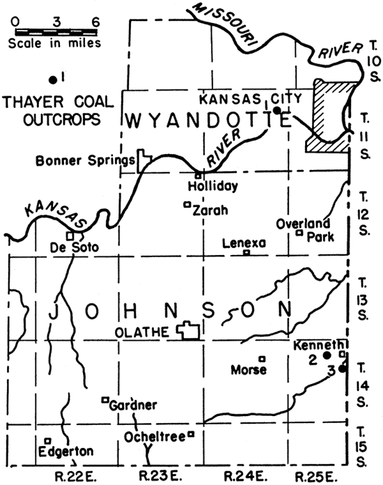
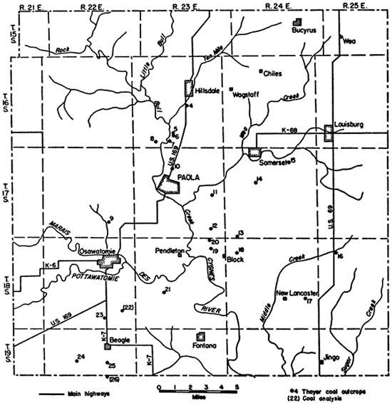
Figure 3--Map of Miami County, Kansas, showing location and outcrop numbers of the Thayer coal.
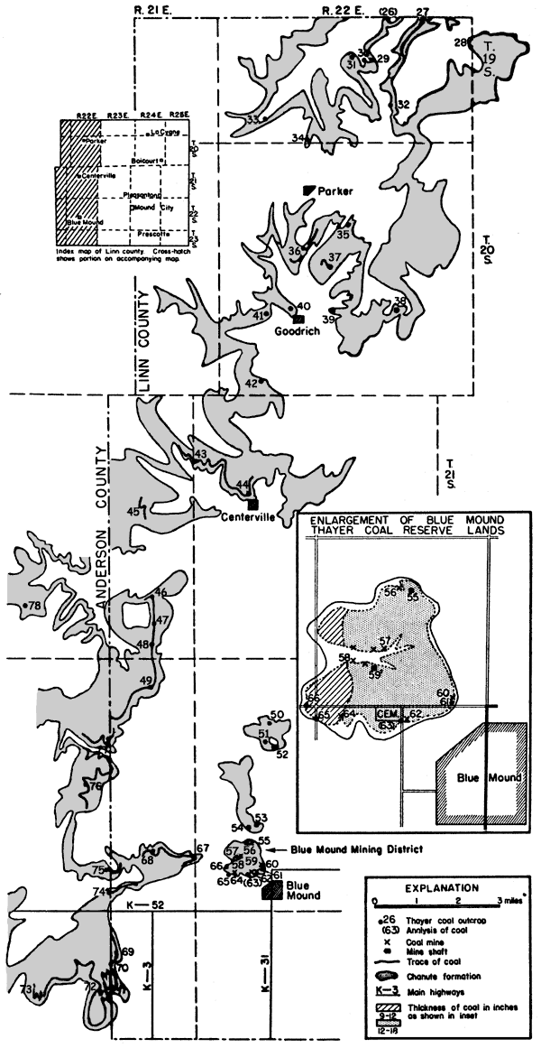
The reserves of Thayer coal in Linn County are restricted to the Blue Mound mining district (fig. 4), a mound and outlier of Chanute shale occupying more than one-half of section 29 and two-tenths of sec. 32, T. 22 S., R. 22 E. north of the town of Blue Mound. The mining in this district has been limited to the edges or escarpments of the mound. The area of coal reserve is estimated at 291 acres; 241 acres, including 271,125 tons of coal, are underlain by coal 9 to 12 inches thick; 50 acres, including 37,500 tons, are underlain by coal 6 to 9 inches thick. The overburden of soft thin-bedded sandstone and sandy shale is 15 to 30 feet thick.
The Thayer coal is 14 inches thick at locality 52 (NE cor. sec. 16) along the escarpment of another mound. Although it has been mined at this place, the abrupt local change in thickness and inadequate data preclude consideration of this area as a potential coal reserve. Inadequate data also prevent the estimation of reserves in secs. 23, 24, 25, and 26 west of Blue Mound (fig. 4).
Figure 4--Map of Linn and Anderson counties, Kansas, showing location and outcrop numbers of the Thayer coal.
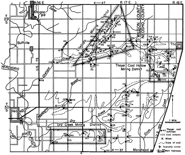
In estimating the coal reserves of Neosho and Wilson counties, the entire region including the Thayer-Coal Hollow mining district of Neosho County and the Chetopa Creek and Dry Creek mining districts of Wilson County was considered as a unit (fig. 7), even though mining activities have been restricted to the named districts (fig. 6). It is estimated that Neosho and Wilson counties include 20,888 acres of reserve coal land containing 25,921,125 tons of coal distributed on the basis of coal thickness as shown in table 9. The reserve coal land is essentially flat except along the borders of the major stream courses. The 15 to 60 feet of overburden consists mainly of soft Cottage Grove sandstone and sandy shale capped in the Chetopa Creek district and a few other localities by a thin remnant of the Iola limestone.
Figure 5--Map of Allen, Neosho, and Wilson counties, Kansas, showing location and outcrop numbers of the Thayer coal.
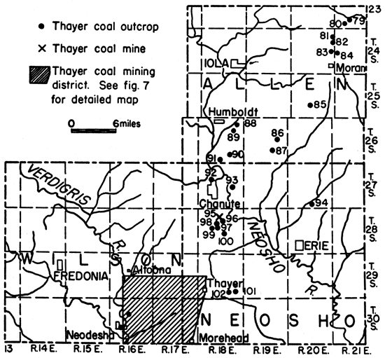
Figure 6--Map of Neosho and Wilson counties, Kansas, showing coal-mining districts and location of mines and outcrops. A larger version of this figure is available.
Montgomery County contains an estimated 8,697 acres of reserve coal land underlain by 10,393,000 tons of coal. Acreage and tonnage of the Montgomery County reserve coal on the basis of the thickness of the bed are shown in table 9. The reserve coal lands of Montgomery County are believed to consist of nine separate areas in all but one of which mining has been carried on in the past (pl. 5). The overburden is 15 to 60 feet thick and consists of thin- to thick-bedded sandstone and sandy shale of the Cottage Grove sandstone. Just south of Independence (loc. 254) the overburden consists of shale capped by sandstone.
Mining of the Thayer coal on a commercial basis has practically ceased. Labor shortage, indifference to mining as an occupation by the younger generation, price ceilings, and competition from other coal beds and other fuels are some of the factors that have contributed to the decline of mining of the Thayer coal. It is estimated that there are 37,000,000 tons of unmined Thayer coal more than 6 inches in thickness in the Kansas City group. For reasons stated elsewhere in this report this coal may reasonably be considered reserve coal.
It is impossible to foresee the requisite economic conditions to bring the Thayer coal bed into significant commercial production. It is important to know our coal reserves, however, even though they may not in some cases be mined for many years in the future. In the case of the Thayer bed, the data contained in this report can be used to furnish the basis for many small operations that might supply an extremely local area. The thicker parts of the bed, particularly where more than 18 inches, should be looked upon as a commercial reserve at the present time. The quantity of mineable coal in the Thayer bed assumes greater importance when we consider that it is sufficient to supply an amount of coal equal to the present total coal output of the state for 9 years.
Although it is reasonably certain that the coal beneath the surface of the coal reserve lands forms a continuous deposit and that within limits the thickness of the coal is fairly uniform and predictable, it is nevertheless recommended that sufficient tests by core drilling be made to establish definitely the actual thickness of the coal in areas thought worthy of exploitation. Such tests could be made with relative ease, speed, and low cost as the nonresistant sandstone overburden is usually less than 40 feet and seldom more than 60 feet thick.
The Neosho-Wilson counties reserve coal lands (fig. 7), comprising 20,088 acres, offer the best possibilities for large-scale coal mining. This region includes the Thayer-Coal Hollow mining district of Neosho County and the Chetopa Creek and Dry Creek mining districts of Wilson County. The area surrounding the Chetopa Creek mining district in Wilson County (figs. 6 and 7) is the most promising in this region. As indicated by the coal outcrops, it contains the thickest coal deposits. The area includes the only commercial coal mine (strip) (loc. 202) of any importance in the entire Thayer coal region. Partly capped by the basal limestone member of the Iola limestone formation, the overburden ranges from 12 feet to 30 feet in thickness. It is estimated that there are 3,302 acres containing coal 18 inches or more thick in the area surrounding the Chetopa Creek mining district. Quantitatively, 7,429,500 tons of coal should be recoverable from this reserve land.
Figure 7--Map of Neosho and Wilson counties, Kansas, showing reserve coal lands.
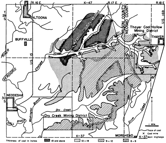
Adjacent to the Chetopa Creek reserve coal lands just mentioned are the 12- to 18-inch coal reserve lands that extend eastward to the Thayer-Coal Hollow district and southward toward the Dry Creek mining district (figs. 6 and 7). These reserve coal lands comprise an estimated 7,247 acres underlain by 10,870,500 tons of coal. In addition to the areas in which the coal is more than 12 inches thick, there are more than 6,000 acres of 9 to 12-inch coal lands and more than 3,000 acres where the coal is 6 to 9 inches thick. These areas are estimated to contain an additional 7,621,125 tons of coal.
The Montgomery County coal reserve lands (pl. 5) total 8,697 acres of which 2,682 acres are underlain by coal 12 to 18 inches thick, 5,190 acres by coal 9 to 12 inches thick, and 750 acres by coal 6 to 9 inches thick. South of Independence, coals more than 18 inches thick are estimated to underlie at least 75 acres. Because the coal reserve lands of the county are scattered and none contain more than 3,000,000 tons of coal, it is inferred that small scale operators are perhaps best suited to the area. With the exception of the thickness of the coal, conditions in all of the nine reserve areas in the county are essentially the same. The overburden is composed of soft sandstone except for the small area south of Independence where the coal is overlain directly by shale. South of Independence, as in the Spring-Fawn Creek mining district (pl. 5), the sandstone is generally thicker bedded than it is in the areas in the northern part of the county. The overburden ranges from 15 to 60 feet in thickness. North of Independence the overburden is seldom more than 30 feet thick, but in the Spring-Fawn Creek area in the southern part of the county it is 60 feet thick (pl. 5).
Because conditions are essentially the same in the nine reserve coal areas in the county, it is not advisable to suggest any one of them for special consideration. Other conditions being equal, it follows that those areas in which the coal is thickest might normally be investigated first. On the other hand, areas in which the coal is thinner but has greater areal extent and thinner overburden may prove to yield more returns. The salient conditions pertaining to the more important parts of each of the nine reserve coal areas in the county are summarized in table 10.
Table 10--Summary of salient conditions pertaining to the Montgomery County, Kansas, reserve coal lands.
| Area | Location | Thickness of coal (inches) |
Thickness of overburden (feet) |
Character of overburden |
Acres | Estimated reserves (tons) |
|---|---|---|---|---|---|---|
| Irish creek | 25, 35, 36-31-16 E | 12-18 | 15-40 | Thin-bedded sandstone | 650 | 975,000 |
| Choteau creek | 18, 19-31-17 E | 12-18 | 20-30 | Thin-bedded sandstone | 188 | 282,000 |
| 7, 8, 18, 24-31-16 E | 9-12 | 20-30 | Thin-bedded sandstone | 875 | 984,375 | |
| Sycamore | 19, 30, 31-31-16 E | 9-12 | 20-40 | Thin-bedded sandstone and shaly sandstone |
1,063 | 1,195,875 |
| 6-32-16 E | 9-12 | |||||
| Coal creek | 24,25-33-15 E | 12-18 | 30-40 | Shale to shaly sandstone | 625 | 937,500 |
| Bluff creek | 7, 18-34-16 E | 12-18 | 15-20 | Thin-bedded sandstone | 350 | 525,000 |
| Coal, Clear, and Bluff creeks |
24, 25, 36-33-15 E | 9-12 | 20-35 | Shaly sandstone to thin-bedded sandstone |
1,888 | 2,124,000 |
| 1-34-15 E | 9-12 | 20-35 | ||||
| 19, 30-33-16 E | 9-12 | 20-30 | ||||
| 6-34-16 E | 9-12 | 30-40 | ||||
| Spring-Fawn creeks | 15, 16, 21, 22-34-15 E | 12-18 | 40-60 | Massive sandstone | 769 | 1,153,500 |
| Independence, North* | 13,24-32-15 E | 9-12 | 20-30 | Shaly sandstone capped by sandstone |
788 | 211,500 |
| 18,19-32-16 E | 9-12 | 20-30 | ||||
| Independence, South | 6-33-16 E | 12-18 | 30-40 | Shale and thin-bedded sandstone |
100 | 150,000 |
| 6-33-16 E | 18+ | 30-40 | 75 | 168,750 | ||
| *Coal underlying City of Independence not considered. | ||||||
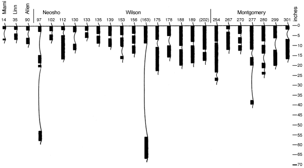
Figure 8--Thayer coal sections showing variations in the number of coal beds, intervening clay partings, thicknesses, and relative positions of the thicker coals and the thinner coals. A larger version of this figure is available.
The only Thayer coal reserve area outside of Neosho, Wilson, and Montgomery counties is the Blue Mound area in Linn County (fig. 4), described elsewhere in this report. Of the 291 acres of reserve coal land, 241 are underlain by coal 9 to 12 inches thick. Because the overburden consists of soft thin-bedded sandstone and sandy shale and is no more than 15 to 20 feet thick, it is reasonable to assume that strip-mining costs should not be excessive and that the extraction of 27,000 tons of coal might prove profitable.
As estimated in the section on "Production" (pp. 103-106), only 35 percent of the coal in the narrow belt paralleling the trace of coal outcrop has been mined. An equal amount of coal can undoubtedly be recovered by the "gophering" type of mining practiced by the noncommercial farmer-miner, as the coal is much more widespread than is realized by the people living in the coal region.
To facilitate the finding of outcrops of the Thayer coal and the location of mines for future coal exploitation as well as for use in further stratigraphic work, all coal outcrops and mine locations known to exist are listed by counties in tables 11 to 16.
Table 11--Register of Thayer coal outcrops in Wyandotte, Johnson, and Miami counties, Kansas. Parentheses around outcrop numbers indicate analyses in table 4. Authority: J., Jewett; N., Newell; S., Schoewe.
| Outcrop No. |
Location | Type of outcrop |
Thickness of coal (inches) |
Stratigraphic position of coal within Chanute formation |
Authority | |
|---|---|---|---|---|---|---|
| Wyandotte County | ||||||
| 1 | SW cor. | 12-11-24 E | Road cut | Streak | At top | J. N. |
| Johnson County | ||||||
| 2 | 0.2 mi. W. of SE cor. | 4-14-25 E | Road cut | 0.25-1 | 15 feet below top | S. |
| 3 | SE cor. | 10-14-25 E | Road cut | Streak | 4.7 feet below top | N. |
| Miami County | ||||||
| 4 | NW cor. NE | 22-16-23 E | Road cut | 0.5-2 | 18.1 feet below top | S. |
| 5 | NE cor. | 33-16-23 E | Road and RR. cut | 1.5-2 | 18.1 feet above base | S. |
| 6 | Near cen. N. line | 33-16-23 E | RR. cut | 3.5 | 21 feet above base | N. |
| 7 | Near cen. | 33-16-23 E | RR. cut | 6 | 20 feet below top | N. |
| 8 | S. of cen | 32-16-23 E | Road cut | 3 | 16 feet above base | S.N. |
| 9 | 0.25 mi. E. of SW cor. | 26-17-22 E | Road cut | 8.5 | 0.2 feet below top | N. |
| 10 | NE cor. SW | 9-17-23 E | Composite--RR. cut to top of quarry |
3 | 15.5 feet above base | N. |
| 11 | NW cor. | 24-17-23 E | Road cut | 3.5 | 14 feet above base | S.N. |
| 12 | 0.3 mi. S. of NW cor. NW | 36-17-23 E | Road cut | 4 | 12.5 feet above base | S. |
| 13 | 0.25 mi. W. of SE cor. | 31-17-24 E | Road cut | 3 | 13 feet above base | N. |
| 14 | 0.15 mi. S. of NE cor. | 17-17-24 E | Road cut | 0.5-1.5 | 14 feet above base | S. |
| 15 | S. side of SW | 6-18-24 E | Road cut | 3 | 13 feet above base | N. |
| 16 | SE cor. | 6-18-25 E | Road cut | 3 | 4.5 feet below top | N. |
| 17 | E. of SW cor. | 24-18-24 E | Road cut | 3.5 | 12 feet above base | N. |
| 18 | SW cor. | 2-17-24 E | Road cut | 1-1.5 | 18 feet above base | S. |
| 19 | 0.25 mi. N. of SE cor. | 2-18-23 E | Road cut | 3 | 11.5 feet above base | S.N. |
| 20 | NE cor. | 2-18-23 E | Road cut | 3 | 15.5 feet below top | N. |
| 21 | 0.25 mi. W. of cen. E. line | 20-18-23 E | Road cut | 3 | 16.5 feet above base | N. |
| (22) | 0.25 mi. N. of SW cor. | 25-18-22 E | Road cut | 3 | 11.2 feet above base | S.N. |
| 23 | 0.25 mi. S. of NE cor. | 34-18-22 E | Road cut | Streak | Near top | N. |
| 24 | NW cor. | 16-19-22 E | Road cut | 3 | 30 feet below top | N. |
| 25 | E. side of NE | 15-19-22 E | Road cut | 6 | 11 feet above base | N. |
Table 12--Register of Thayer coal outcrops and mines in Linn County, Kansas. Parentheses around outcrop numbers indicate analyses in table 4. Authority: J., Jewett; N., Newell; S., Schoewe.
| Outcrop No. |
Location | Type of outcrop |
Thickness of coal (inches) |
Stratigraphic position of coal within Chanute formation |
Authority | |
|---|---|---|---|---|---|---|
| (26) | NE cor. | 22-19-22 E | Road cut | 6 | 10 feet above base | S. |
| 27 | 0.1 mi. W. of NE cor. | 23-19-22 E | Road cut | S. | ||
| 28 | E. line | 24-19-22 E | 12 | 6.5 feet above base | N. | |
| 29 | NW cor. NE | 27-19-22 E | 3 | 16 feet above base | J. | |
| 30 | NE cor. NW | 27-19-22 E | 3.5 | J. | ||
| 31 | SW cor. | 22-19-22 E | Road cut | 5 | 12 feet above base | S. |
| 32 | NW cor. | 35-19-22 E | 3.5 | 12 feet above base | J. | |
| 33 | SW cor. NW | 32-19-22 E | 6 | 10.6 feet above base | N. | |
| 34 | E. line | 32-19-22 E | 6 | 20.3 feet below top | J. | |
| 35 | 0.2 mi. W. of NE cor. | 16-20-22 E | Road cut | 6 | 13 feet above base | J. |
| 36 | SW cor. NW | 16-20-22 E | Road cut | 5 | S. | |
| 37 | SW cor. SE | 16-20-22 E | Road cut | 3 | 14 feet above base | S. |
| 38 | 0.15 mi. E. of SW cor. | 23-20-22 E | Road cut | 9 | 30 feet below top | S. |
| 39 | NW cor. NE | 21-20-22 E | Road cut | 2 | 15 feet above base | S. |
| 40 | 0.3 mi. W. of SE cor. | 20-20-22 E | Road cut | 3 | 12.5 feet above base | S. |
| 41 | NW cor. | 29-20-22 E | Road cut | 6 | 15 feet above base | N. |
| 42 | 0.3 mi. N. of SE cor. | 31-20-22 E | Road cut | 4 | 10.5 feet above base | S. |
| 43 | NW cor. SW | 7-21-22 E | Road cut | 5 | 8 feet above base | S. |
| 44 | W. of school | 17-21-22 E | Road cut | 5 | 12 feet above base | S. |
| 45 | 0.1 mi. W. of SE cor. NE | 14-21-21 E | Road cut | S. | ||
| 46 | 0.4 mi. N. of SW cor. | 25-21-21 E | Road cut | 8 feet above base | S. | |
| 47 | 0.3 mi. S. of NW cor. | 35-21-21 E | Road cut | 3 | 8 feet above base | S. |
| 48 | 200 ft. N. of RR. tracks | 36-21-21 E | Road cut | 4 | S. | |
| 49 | 0.2 mi. N. of SE cor. | 2-22-21 E | Road cut | 3 | S. | |
| 50 | NE cor. SE | 8-22-22 E | Road cut | Trace | 23 feet above base | S. |
| 51 | SE cor. | 8-22-22 E | Road cut | 1-2 | S. | |
| 52 | NW cor. | 16-22-22 E | Mine | 14 | S. | |
| 53 | 0.3 mi. W. of SE cor. | 20-22-22 E | Road cut | 8 | S. | |
| 54 | NW cor. NE | 29-22-22 E | Road cut | 3 | S. | |
| 55 | NW cor. SW NE | 29-22-22 E | Shaft and drift mines | S. | ||
| 56 | 0.2 mi. N. of SE cor. NW | 29-22-22 E | Mines | S. | ||
| 57 | Cen. SW | 29-22-22 E | Mines | 10+ | S. | |
| 58 | Cen. SW | 29-22-22 E | Mines | S. | ||
| 59 | NE cor. SW | 29-22-22 E | Mine (shaft) | S. | ||
| 60 | 0.2 mi. W. of SE cor. | 29-22-22 E | Mines | 12 | S. | |
| 61 | 0.2 mi. W. of SE cor. | 29-22-22 E | Road cut | 12 | S. | |
| 62 | NW cor. NE | 32-22-22 E | Mines | S. | ||
| (63) | SE cor. of cemetery, NE cor. NW |
32-22-22 E | Road cut | 14 | S. | |
| 64 | 0.15 mi. E. and 0.1 mi. S. of NW cor. |
32-22-22 E | Mine | S. | ||
| 65 | 0.1 mi. S. of NE cor. | 31-22-22 E | Road cut | 3 | S. | |
| 66 | 0.2 mi. W. of SE cor. | 30-22-22 E | Road cut | 12 | S. | |
| 67 | 0.3 mi. N. of SE cor. | 24-22-21 E | Road cut | 8.25 | S. | |
| 68 | Cen. E. line | 23-22-21 E | Road cut | 4.5 | S. | |
| 69 | 0.15 mi. E. of SW cor. | 2-23-21 E | Road cut | 3 | S. | |
| 70 | 0.2 mi. S. of NW cor. | 11-23-21 E | Road cut | 3 | S. | |
| 71 | SW cor. | 11-23-21 E | Road cut | 3 | S. | |
Table 13--Register of Thayer coal outcrops in Anderson and Allen counties, Kansas. Authority: A., Adams; H., Haworth; N., Newell; S., Schoewe.
| Outcrop No. |
Location | Type of outcrop |
Thickness of coal (inches) |
Stratigraphic position of coal within Chanute formation |
Authority | |
|---|---|---|---|---|---|---|
| Anderson County | ||||||
| 72 | 0.2 mi. W. of SE cor. | 10-23-21 E | Road cut | S. | ||
| 73 | 0.1 mi. E. of SW cor. | 9-23-21 E | Road cut | S. | ||
| 74 | 0.3 mi. N. of SE cor. | 34-22-21 E | Road cut | S. | ||
| 75 | 0.1 mi. W. of NE cor. | 34-22-21 E | Road cut | 3.5 | 10 feet above base | S. |
| 76 | SE cor. SW | 15-22-21 E | Road cut | 2 | S. | |
| 77 | NE cor. | 15-22-21 E | Road cut | 1 | S. | |
| 78 | SW cor. | 28-21-21 E | 6 | N. | ||
| Allen County | ||||||
| 79 | 0.5 mi. S. of NE cor. | 29-23-21 E | Road cut | S. | ||
| 80 | 0.2 mi. W. of SE cor. | 29-23-21 E | Road cut | 3 | S. | |
| 81 | SE cor. | 1-24-20 E | Road cut | 3.5 | 6.5 feet above base | N. |
| 82 | 0.2 mi. S. of NE cor. | 12-24-20 E | Road cut | 3.5 | 6.5 feet above base | N. |
| 83 | 0.2 mi. N. of SW cor. | 13-24-20 E | Road cut | 4 | 10.2 feet below top | S. |
| 84 | 0.2 mi. E. of SW cor. | 18-24-21 E | Road cut | 8 | S. | |
| 85 | NW cor. | 27-25-20 E | 6 | 13 feet below top | N. | |
| 86 | Cen. | 14-26-19 E | Stream bank | 9 | S. | |
| 87 | Cen. SE | 22-26-19 E | Stream bank | 5 | S. | |
| 83 | SW cor. | 1-26-18 E | Creek and road cut | 3.5 | 18 feet below top | N. |
| 89 | SW cor. NE | 11-26-18 E | Stream bank | 7 | 23 feet below top | S.H.A. |
| 90 | SE cor. SW | 26-26-18 E | Stream bank | 5 | S. | |
| 91 | SE cor. | 33-26-18 E | 6 | 13 feet above base | N. | |
Table 14--Register of Thayer coal outcrops and mines in Neosho County, Kansas. Parentheses around outcrop numbers indicate analyses in table 4. Authority: J., Jewett; N., Newell; S., Schoewe.
| Outcrop No. |
Location | Type of outcrop |
Thickness of coal (inches) |
Stratigraphic position of coal within Chanute formation |
Authority | |
|---|---|---|---|---|---|---|
| 92 | Ash Grove Cement Plant, Chanute |
17-27-18 E | Quarry | 111.3 | 6 feet below top | J. |
| 93 | Cen. | 23-27-18 E | Road cut | 2 | S. | |
| 94 | NW cor. | 34-27-20 E | Ravine | 3.6 | 7.2 feet above base | J. |
| 95 | 0.1 mi. W. of road, NE cor. | 9-28-18 E | Mine | 5 | S. | |
| 96 | NE cor. | 9-28-18 E | Road cut | 5 | S. | |
| 97 | 0.2 mi. W. of road, S. line NE |
9-29-18 E | Heads of draws | 14 | S. | |
| 98 | SE cor. SW | 9-28-18 E | 7.2 | 26 feet below top | N. | |
| 99 | 150 ft. S. of bridge, NW cor. | 16-28-18 E | Creek Lank | 3 | 37.5 feet below top | S. |
| 100 | SE cor. NE | 15-23-18 E | Road cut | 2.4 | 10 feet above base | N. |
| 101 | 0.2 mi. W. of SE cor. | 27-29-18 E | Road cut | 5 | S. | |
| 102 | SE cor. | 28-29-18 E | Creek bank | 7 | S. | |
| 103 | 0.2 mi. N. of SW cor. NW | 25-29-17 E | Road cut | 25 | S. | |
| 104 | Cen. NE | 26-29-17 E | Mine | S. | ||
| 105 | 0.1 mi. E. of SW cor. SE | 23-29-17 E | Road cut | S. | ||
| 106 | 0.2 mi. S. of NE cor. SW | 26-29-17 E | Road cut | 4 | S. | |
| 107 | SE cor. | 26-29-17 E | Road cut | S. | ||
| 108 | NW cor. NE | 35-29-17 E | Road cut | 14 | S. | |
| 109 | NW cor. SE | 35-29-17 E | Road cut | S. | ||
| 110 | 0.1 mi. W. of road, NE cor. NE | 36-29-17 E | Mines | S. | ||
| 111 | 0.2 mi. S. of NE cor. | 36-29-17 E | Road cut | 14 | S. | |
| 112 | 0.2 mi. S. of DM cor. and E. | 31-29-18 E | Mines | S. | ||
| (113) | SW NW | 31-29-18 E | Mines | 14 | S. | |
| 114 | SE | 36-29-17 E | Mines | 14 | S. | |
| 115 | 0.3 mi. E. of SE cor. | 36-29-17 E | Road cuts, mine | S. | ||
| 116 | N. line SE NW | 1-30-17 E | Mines | S. | ||
| 117 | SE cor. NE | 1-30-17 E | Mines | S. | ||
| 118 | NW | 6-30-18 E | Mines | S. | ||
| 119 | sw | 6-30-18 E | Mines | S. | ||
| 120 | 0.1 mi. S. of road, NE cor. SW |
1-30-17 E | Mines | S. | ||
| (121) | SW | 1-30-17 E | Mines | 14 | S. | |
| 122 | SE cor. NE | 2-30-17 E | Mines | S. | ||
| (123) | NW | 12-30-17 E | Mines | 14 | S. | |
| 124 | 0.4 mi. S. of NE cor. NW, U.S. 169 |
7-30-18 E | Road cut | S. | ||
| 125 | 0.2 mi. S. of NW cor. | 13-30-17 E | Road cut | S. | ||
Table 15--Register of Thayer coal outcrops and mines in Wilson County, Kansas. Authority: N., Newell; S., Schoewe; Sch., Schrader; W., Whitla.
| Outcrop No. |
Location | Type of outcrop |
Thickness of coal (inches) |
Stratigraphic position of coal within Chanute formation |
Authority | |
|---|---|---|---|---|---|---|
| 126 | 0.4 mi. N. of SW cor. | 22-30-17 E | Road cut | 6 | S. | |
| 127 | 0.1 mi. W. of SE cor. | 10-30-17 E | Road cut | S. | ||
| 128 | 0.4 mi. E. of SW cor. | 10-30-17 E | Road cut | S. | ||
| 129 | 0.1 mi. E. of SW cor. | 10-30-17 E | Road cut | S. | ||
| 130 | NE cor. SE | 9-30-17 E | Road cut | 6 | S. | |
| 131 | 0.1 mi. S. of NW cor. | 15-30-17 E | Road cut | S. | ||
| 132 | 0.1 mi. N. of SW cor. | 15-30-17 E | Road cut | S. | ||
| 133 | 0.3 mi. W. of SE cor. | 16-30-17 E | Road cut | 6 | S. | |
| 134 | 0.3 mi. S. of NW cor. NW | 22-30-17 E | Road cut | S. | ||
| 135 | 0.4 mi. N. of SE cor. | 22-30-17 E | Road cut | 8 | S. | |
| 136 | 0.4 mi. N. of SE cor. | 20-30-17 E | Road cut | S. | ||
| 137 | 0.15 mi. N. of SE cor. | 20-30-17 E | Road cut | S. | ||
| 138 | 0.2 mi. S. of NW cor. | 28-30-17 E | Road cut | S. | ||
| 139 | SW cor. NW | 28-30-17 E | Road cut | 9 | S. | |
| 140 | NE cor. SE | 28-30-17 E | Stream bank | S. | ||
| 141 | 0.2 mi. E. of DM cor. | 27-30-17 E | Road cut | 3 | S. | |
| 142 | 0.3 mi. S. of NW cor. | 34-30-17 E | Road cut | S. | ||
| 143 | 0.4 mi. E. of NW cor. | 33-30-17 E | Road cut | 6 | S. | |
| 144 | 0.3 mi. W. of SE cor. | 32-30-17 E | Road cut | S. | ||
| 145 | 0.2 mi. E. of NW cor | 32-30-17 E | Mine | Sch. | ||
| 146 | 0.2 mi. E. of SW cor. | 29-30-17 E | Road cut | 9 | S. | |
| 147 | SE cor. SW | 30-30-17 E | Ravine | S. | ||
| 148 | 0.2 mi. N. of SW cor. | 30-30-17 E | Road cut | 9 | 24 feet above base | S. |
| 149 | SW cor. | 25-30-16 E | Mine | 10 | S. | |
| 150 | SE | 26-30-16 E | Mine | Sch. | ||
| 151 | SE cor. | 26-30-16 E | Creek bank | 10-12 | 65 feet below top | S.N. |
| 152 | SE cor. NE | 34-30-16 E | Mine | Sch. | ||
| 153 | Verdigris river bridge, SE part of Neodesha |
20-30-16 E | River bank | 10.5 | 4.2 feet below top | S. |
| 154 | 0.25 mi. W. of NE cor. | 23-30-16 E | Road cut | S. | ||
| 155 | NW cor. SW | 13-30-16 E | Road cut | 7 | S. | |
| 156 | SW cor. NW | 13-30-16 E | Creek bank | 12 | S. | |
| 157 | SE cor. NE | 14-30-16 E | Road cut | S. | ||
| 158 | S. of Chetopa cr. bridge, NE cor. |
9-30-16 E | Road cut | 5 | S. | |
| 159 | 0.2 mi. N. of SE cor. | 34-29-16 E | Creek bank | 12 | S. | |
| 160 | 0.15 mi. E. of SW cor. | 35-29-16 E | Mine | S.Sch. | ||
| 161 | NW cor. NE | 35-29-16 E | Creek bank | 2 | S. | |
| 162 | NE cor. SE | 26-29-16 E | Creek bank | S. | ||
| 163 | NW cor. SW | 36-29-16 E | Creek bank | 9-11 | S. | |
| 164 | SE cor. NE | 36-29-16 E | Road cut | S. | ||
| 165 | 0.3 mi. W. of NW cor. | 31-29-17 E | Road cut | 1.5 | S. | |
| 166 | NE cor. | 31-29-17 E | Mine | Sch. | ||
| 167 | SW cor. NF, | 31-29-17 E | Mine | S. | ||
| 168 | Cen. | 31-29-17 E | Creek bank, mines | S. | ||
| 169 | NW cor. SE | 31-29-17 E | Mines surrounding mound |
S. | ||
| 170 | NW cor. NE | 6-30-17 E | Road cut | S. | ||
| 171 | 0.2 mi. W. of NE cor. | 6-30-17 E | Creek bank | 12 | S. | |
| 172 | NE cor. SE | 32-29-17 E | Creek bank | 14 | S. | |
| 173 | Cen. NW | 32-29-17 E | Creek bank, mines | S. | ||
| 174 | W. side | 33-29-17 E | Road cut | 6 | 56 feet below top | S.N. |
| 175 | E. of bridge, NW cor. | 33-29-17 E | Creek bluff | 19 | S. | |
| 176 | SE cor. | 28-29-17 E | Creek bank, mine | Sch. | ||
| 177 | 0.3 mi. N. of SE cor. | 8-29-17 E | Creek bank | S. | ||
| 178 | 0.2 mi. S. of road, SW cor. SE |
27-29-17 E | Creek bluff | 11 | S. | |
| 179 | NW cor. SE | 27-29-17 E | Mine | 7 | S.Sch. | |
| 180 | NW | 27-29-17 E | Mine | Sch. | ||
| 181 | NE cor. | 29-29-17 E | Creek bank | 16.8 | 8 feet below top | N. |
| 182 | W. side | 28-29-17 E | Road cut | 6 | 56 feet below top | N. |
| 183 | N. of road, SE cor. | 29-29-17 E | Gullies | 18 | 40.2 feet below top | Sch.N. |
| 184 | SW cor. | 29-29-17 E | Creek bank, road cut, mines |
9.6 | 8 feet below top | N.S. |
| 185 | Cen. SW | 29-29-17 E | Creek bank, mines | S. | ||
| 186 | 0.15 mi. W. of SW cor. NW | 29-29-17 E | Mine | Sch. | ||
| 187 | Cen. NE | 29-29-17 E | Mine | S. | ||
| 188 | Cen. NE | 29-29-17 E | Road cut | 18 | 5 feet below top | S. |
| 189 | 0.1 mi. S. of NW cor. | 28-29-17 E | Road cut | 19 | 4 feet below top | S. |
| 190 | Cen. SE | 30-29-17 E | Creek bank, mines | S. | ||
| 191 | 0.2 mi. W. of SE cor. NE | 30-29-17 E | Mine | S.Sch. | ||
| 192 | SE cor. NE | 30-29-17 E | Mine, road out | S. | ||
| 193 | 0.1 mi. N. of SW cor. | 29-29-17 E | Mine | S. | ||
| i94 | 0.15 mi. N. of SE cor. SW | 20-29-17 E | Mine | S. | ||
| 195 | 0.1 mi. N. of SW cor. SE | 20-29-17 E | Mine | S. | ||
| 196 | NE cor. SE and south | 20-29-17 E | Mines along creek | S. | ||
| 197 | SE cor. NE | 20-29-17 E | Mines | S. | ||
| 198 | 0.5 mi. S. of NW cor. | 21-29-17 E | Mines | 11 | S.W. | |
| 199 | 0.3 mi. S. of NW cor. | 21-29-17 E | Mines | S. | ||
| 200 | First draw E. of school, NW cor. |
21-29-17 E | Creek bank | S. | ||
| 201 | NE NW | 21-29-17 E | Mines | S. | ||
| 202 | SW | 21-29-17 E | Dunbar strip mine | 17-24 | 1.8-11.5 feet below top | S. |
| 203 | SE cor. SW | 16-29-17 E | Road cut | 12 | 1.5 feet below top | N. |
Table 16--Register of Thayer coal outcrops and mines in Montgomery County, Kansas. Parentheses around outcrop numbers indicate analyses in table 4. Authority: N., Newell; S., Schoewe; Sch., Schrader.
| Outcrop No. |
Location | Type of outcrop |
Thickness of coal (inches) |
Authority | |
|---|---|---|---|---|---|
| 204 | 0.35 mi. E. of NE cor. | 3-31-16 E | Road cut | 4 | S. |
| 205 | 0.3 mi. E. of NE cor. | 3-31-16 E | Road cut | 4 | S. |
| 206 | 0.1 mi. E. of NE cor. | 3-31-16 E | Road cut | 4 | S. |
| 207 | NW cor. | 10-31-16 E | Road cut | S. | |
| 208 | 0.5 mi. E. of NW cor. | 2-31-16 E | Road cut | 7 | S. |
| 209 | NW cor. | 6-31-17 E | Mine | Sch. | |
| 210 | SW cor. NW | 8-31-17 E | Road cut | 10 | S. |
| 211 | 0.3 mi. E. of SW cor. | 8-31-17 E | Road cut | 11 | S. |
| 212 | 0.6 mi. E. of SW cor. | 7-31-17 E | Road cut | 10 | S.N. |
| 213 | 0.3 mi. S. of NW cor. | 12-31-16 E | Road cut | 1.5 | S. |
| 214 | SW cor. | 11-31-16 E | Mine | Sch | |
| 215 | NW cor. SW | 10-31-16 E | Road cut | S. | |
| 216 | 0.2 mi. S. of NE cor. | 16-31-16 E | Road cut | 6 | S. |
| 217 | 0.1 mi. S. of NE cor. | 15-31-16 E | Shaft mine | S. | |
| 218 | SE cor. NE | 15-31-16 E | Mine | Sch. | |
| 219 | 0.4 mi. S. of NE cor. | 15-31-16 E | Road cut | 3 | S. |
| 220 | NW cor. SW | 18-31-17 E | Road cut | 2 | S. |
| (221) | 0.6 mi. E. of SW cor. | 18-31-17 E | Road cut | 14 | S. |
| 222 | 0.2 mi. W. of SE cor. | 24-31-16 E | Road cut | 9 | S. |
| (223) | 0.2 mi. W. of SE cor. | 23-31-16 E | Road cut | 11 | S. |
| 224 | 0.2 mi. W. of SE cor. NE | 22-31-16 E | Creek bank | S. | |
| 225 | 0.2 mi. S. and 0.1 mi. W. of NE cor. |
21-31-16 E | Ravine | 10 | S. |
| 226 | 0.25 mi. S. of NW cor. NE | 21-31-16 E | Gully | 2 | S. |
| 227 | SW cor. SE | 18-31-16 E | Road cut | 7 | S. |
| 228 | SE cor. SW | 18-31-16 E | Mine | Sch. | |
| 229 | Cen. NF, | 19-31-16 E | Mine | Sch. | |
| 230 | SE cor. | 19-31-16 E | Mine | Sch. | |
| 231 | SE cor. and north | 19-31-16 E | Mines | S. | |
| (232) | 0.4 mi. N. and 100 yds. E. of SW cor. |
30-31-16 E | Creek bank | 13 | S. |
| 233 | NE cor. NW | 35-31-16 E | Mines | 18 | S. |
| 234 | SW cor. SE | 26-31-16 E | Mine | Sch. | |
| 235 | 0.2 mi. E. and 0.1 mi. N. of SE cor. |
26-31-16 E | Strip mines | 12 | S. |
| 236 | 0.35 mi. N. and 0.2 mi. E. of SW cor. |
25-31-16 E | Mine | 11 | S. |
| 237 | 0.3 mi. S. of NW cor. | 30-31-17 E | Road cut | 9 | S. |
| 238 | NW cor. | 36-31-16 E | Road cut | 15 | S. |
| 239 | Cen. NW | 36-31-16 E | Shaft mine | 16 | S. |
| 240 | 0.4 mi. N. of SW cor. | 36-31-16 E | Road cut | 15 | S. |
| 241 | SW cor. | 36-31-16 E | Mine | Sch. | |
| 242 | 0.4 mi. W. of SE cor. | 35-31-16 E | Road cut | 12 | S. |
| 243 | SE cor. | 34-31-16 E | Road cut | Trace | S.N. |
| 244 | 0.1 mi. E. of W cor. | NE 6-32-16 E | Road cut | S. | |
| 245 | Cen. | 7-32-16 E | Creek bank | S. | |
| 246 | 0.3 mi. N. of SE cor. | 7-32-16 E | Road cut | 3 | S. Sch. |
| 247 | N. line of SI/2 | 13-32-15 E | Road cut | 12 | S.N. |
| 248 | 0.3 mi. W. of U.S. 75, SE | 13-32-15 E | Road cut | 10 | S.N. |
| 249 | 0.2 mi. S. of Elk river bridge on U.S. 75 |
18-32-16 E | Road cut | 12 | S. Sch. |
| 250 | Cen. SE, Independence park zoo |
19-32-16 E | Ravine | 12 | Sch. S. |
| 251 | SE cor. NW | 19-32-16 E | Mine | Sch. | |
| (252) | Independence park, water works plant |
19, 30-32-16 E | Road cut, mines | 12-14(1) | Sch. S.N. |
| 253 | SE NW | 6-32-16 E | Road cut | 14 | S. |
| 254 | Cen. | 6-33-16 E | Brick plant quarry | 25 | Sch. S. |
| 255 | SE cor. NE | 6-33-16 E | Mine | Sch. | |
| 256 | 0.1 mi. S. of NE cor. NW | 18-33-16 E | Mine | Sch. S. | |
| 257 | Cen. NW | 17-33-16 E | Mines | Sch. S. | |
| 258 | NW cor. SE | 17-33-16 E | Road cut | S. | |
| 259 | 0.2 mi. W. and 0.4 mi. N. of SE cor. SW |
17-33-16 E | Mines | S. | |
| 260 | 0.15 mi. E. of NW cor. SW | 17-33-16 E | Mine | Sch. | |
| 261 | 0.3 mi. W. of SE cor. | 13-33-15 E | Road cut | 13 | N. |
| 262 | 0.4 mi. S. of NW cor., Coal creek |
19-33-16 E | Mine | Sch. | |
| 263 | W. line SE | 24-33-15 E | Creek bank mines | 13 | S. |
| 264 | NE cor. SE | 24-33-15 E | Road cut | 9 | S. |
| 265 | 0.4 mi. N. of SW cor., Coal creek |
19-33-16 E | Mine | Sch. | |
| 266 | 200 yds. S. of road, 0.3 mi. E. of NW cor. |
25-33-15 E | Creek bank, mine | 13 | S. |
| 267 | 0.25 mi. S. and 0.1 mi. E. of NW cor. NE |
30-33-16 E | Road cut | 10.5 | S. |
| 268 | SW cor. SE | 30-33-16 E | Mine | S. Sch. | |
| 269 | 0.2 mi. S. of NE cor. | 36-33-15 E | Road cut | 8 | S. |
| 270 | 0.2 mi. W. of SE cor. | 36-33-15 E | Road cut | 9.5 | S. |
| 271 | 0.2 mi. E. of SW cor. | 31-33-16 E | Road cut | S. | |
| 272 | 0.4 mi. E. of SW cor. | 1-33-15 E | Creek bank, mine | S. | |
| 273 | 0.4 mi. E. of NW cor. | 12-34-15 E | Creek bank, mine | S. Sch. | |
| 274 | 0.3 mi. S. of DM cor. | 12-34-15 E | Road cut | 20 | S. |
| 275 | NW cor. SW | 13-34-15 E | Road cut | S. | |
| 276 | SE cor. pasture, 0.1 mi. N. and W. of SE cor. |
13-34-15 E | Ravine | S. | |
| 277 | NW cor. SW | 7-34-16 E | Road cut | 18 | S. |
| 278 | 0.5 mi. W. of SE cor., 0.1 mi. N. of road, S. line |
7-34-16 E | Mines | S. | |
| 279 | 0.1 mi. S. of NE cor. | 7-34-16 E | Road cut | S. | |
| 280 | NE cor. | 18-34-16 E | Road cut | 8 | S. |
| 281 | Cen. NE NW | 18-34-16 E | Mines | S. | |
| 282 | 0.1 mi. S. of NW cor. | 18-34-16 E | Road cut | 15 | S. |
| 283 | 0.1 mi. S. and E. of NW cor. NE |
16-34-15 E | Stream bank | S. | |
| 284 | NE cor. and 0.3 mi. W. along stream |
16-34-15 E | Bluffs, mines | S. | |
| 285 | NW cor. and 0.3 mi. S. along stream |
15-34-15 E | Bluffs, mines | S.N. | |
| 286 | W. and S. lines | 26-34-15 E | 9.6(2) | N. Sch. | |
| 287 | S. bank Fawn creek and road | 21-34-15 E | Mines | S. | |
| 288 | Ravine parallel to road, SW | 22-34-15 E | Mines | S. Sch. | |
| (289) | 0.5 mi. E. and 0.15 mi. N. of SW cor. |
22-34-15 E | Mines | 10 | S. |
| 290 | 0.35 mi. W. of SE cor. | 22-34-15 E | Road cut | S. | |
| 291 | 0.15 mi. S. and 0.4 mi. W. of NW cor. |
27-34-15 E | Ravine | S. | |
| 292 | SW cor. NW | 26-34-15 E | Escarpment | S. | |
| 293 | 0.1 mi. E. of SW cor. | 26-34-15 E | Road cut | 3 | S. |
| 294 | 0.2 mi. S. of NW cor. | 35-34-15 E | Road cut | S. | |
| 295 | 150 ft. S. of RR. tracks | 35-34-15 E | Road cut | 6 | S. |
| 296 | 250 ft. E. of bridge, NE cor. NW |
2-35-15 E | Road cut | 1 | S. |
| 297 | 0.5 mi. N. of SE cor. | 3-35-15 E | Road cut | S. | |
| 298 | 0.25 mi. N. of SE cor. | 3-35-15 E | Road cut | S. | |
| 299 | 0.3 mi. S. of NE cor. | 10-35-15 E | Road cut | 14 | S. |
| 300 | NE cor. SE | 10-35-15 E | Road cut | S. | |
| 301 | Cen. NW | 11-35-15 E | Road cut | 12 | S. |
|
(1) Coal 42.7 feet above the base of the Chanute shale formation. (1) Coal 58.3 feet below the top of the Chanute shale formation. |
|||||
The following bibliography comprises the most important references on Kansas coal.
Abernathy, G. E., 1937, The Cherokee group of southeastern Kansas: Kansas Geol. Soc., Guidebook 11th Ann. Field Conf., pp. 18-23, figs. 5, 6.
Adams, G. I., Girty, G. H., and White, David, 1903, Stratigraphy and paleontology of the Upper Carboniferous rocks of the Kansas section: U. S. Geol. Survey, Bull. 211, pp. 1-123, figs. 1-10, pls. 1-4.
Adams, G. I., Haworth, Erasmus, and Crane, W. R., 1904, Economic geology of the Iola quadrangle, Kansas: U. S. Geol. Survey, Bull. 238, pp. 1-83, figs. 1-13, pls. 1-11.
Allen, H. C., 1925, The chemistry of Kansas coal: Kansas Univ. Bull., vol. 26, no. 5, Chem. Research Div., Bull. 4, pp. 127-202, pls. 1-3.
Bailey, E. H. S., 1889, The composition of Kansas coals: Kansas Acad. Sci. Trans., vol. 11, pp. 46-49.
Bailey, E. H. S., and Blake, L. I., 1889, Composition and evaporative power of Kansas coals: Kansas State Board Agr., 6th Biennial Rept., pt. 2, pp. 157163.
Bain, H. F., 1902, The western interior coal field: U. S. Geol. Survey, 22d Ann. Rept., pp. 333-366, pls. 22-24.
Barkley, J. F., and Burdick, L. R., 1941, The various B.T.U. values of a coal: U. S. Bur. Mines, Information Cire. 7193, pp. 1-26.
Blake, L. I., 1889, The evaporative power of Kansas coals: Kansas Acad. Sci. Trans., vol. 11, pp. 1-129.
Bohnstengel, Walter, 1913, Kansas fuels: coal, oil, gas. Sulphur content of bituminous coal: Kansas Univ., Eng. Bull. 3, pp. 1-40, figs. 1-3, pl. 1.
Bowsher, A. L., and Jewett, J. M., 1943, Coal resources of the Douglas group in east-central Kansas: Kansas Geol. Survey, Bull. 46, pp. 1-94, figs. 1-12, pls. 1-6. [available online]
Braidwood, J. R., 1886, The coal deposits of Kansas; System of working out coal in Kansas coal mines: State Inspector of Coal Mines of Kansas, 2d Ann. Rept., pp. 1-192.
Broadhead, G. C., 1882, Geological notes on a part of southeast Kansas: Kansas City Review of Sci., vol. 6, pp. 172-175.
Brown, Bennett, 1896, Coal--its discovery, development, and importance: Kansas State Inspector of Coal Mines, 8th Ann. Rept., pp. 8-20.
Brown, Bennett, 1896, Different systems of coal mining as practiced in Kansas: Kansas State Inspector of Coal Mines, 8th Ann. Rept., pp. 21-26.
Campbell, M. R., 1912, Miscellaneous analyses of coal samples from various fields of the United States: U. S. Geol. Survey, Bull. 471j, pp. 629-655.
Campbell, M. R., 1917, The coal fields of the United States; general introduction: U. S. Geol. Survey, Prof. Paper 100, pp. 1-33.
Cooper, C. L., 1928, The correlation of coals in Oklahoma and Kansas: Oklahoma Acad. Sci. Proc., vol. 7, pp. 158-168.
Crane, W. R., 1896, "Horsebacks" in the Kansas coal measures: Kansas Univ. Quart., vol. 4, pp. 145-151.
Crane, W. R., 1898, Special report on coal: Kansas Univ. Geol. Survey, vol. 3, pt. 2, pp. 107-336, figs. 4-54, pls. 31-70.
Crane, W. R., 1901, Kansas coal mining: Eng. and Min. Jour., vol. 72, pp. 748-752.
Crane, W. R., 1902, The Kansas coal mines of the Missouri valley: Eng. and Min. Jour., vol. 74, pp. 514-516.
Crane, W. R., 1903, Coal fields of north-central Kansas: Mines and Minerals, vol. 24, p. 94.
Delplace, John, 1943, Annual report of the Mine Inspection Division and the Mine Rescue Station, Labor Department, Kansas (1942), pp. 1-64.
Fieldner, A. C., Smith, H. I., Fay, A. H., and Sanford, Samuel, 1914, Analyses of mine and car samples of coal collected in the fiscal years 1911 to 1913: U. S. Bur. Mines, Bull. 85, pp. 1-444.
Fieldner, A. C., Smith, H. I., Paul, J. W., and Sanford, Samuel, 1918, Analyses of mine and car samples of coal collected in the fiscal years 1913 to 1916: U. S. Bur. Mines, Bull. 123, pp. 1-478, figs. 1, 2.
Fieldner, A. C., Selvig, W. A., and Paul, J. W., 1922, Analyses of mine and car samples of coal collected in the fiscal years 1916 to 1919: U. S. Bur. Mines, Bull. 193, pp. 1-391, figs. 1, 2.
Fieldner, A. C., Cooper, H. M., and Osgood, F. D., 1929, Analysis of (Kansas coal) mine samples: U. S. Bur. Mines, Tech. Paper 455, pp. 30-37.
Findlay, G. W., 1888, State Inspector of Coal Mines, 3d Ann. Rept., pp. 1-68.
Frolich, P. K., 1943, Petroleum, past, present and future. II: Science, vol. 98, no. 2553, pp. 484-487, figs. 12, 13.
Geyer, J. N., and Osgood, F. D., 1929, Description of (Kansas coal) samples: U. S. Bur. Mines, Tech. Paper 455, pp. 38-49.
Glennon, William, 1934, Annual Report of Coal Mine and Metal Mine Inspection and Mine Rescue Departments (1933), pp. 1-115.
Glennon, William, 1935, Annual Report of Coal Mine and Metal Mine Inspection and Mine Rescue Departments (1934), pp. 1-101.
Glennon, William, 1937, Annual Report of Coal Mine and Metal Mine Inspection and Mine Rescue Departments (1936), pp. 1-68.
Gould, C. N., 1901, The Dakota Cretaceous of Kansas and Nebraska: Kansas Acad. Sci. Trans., vol. 17, pp. 122-178, pls. 4-12.
Gray, Alfred, 1875, Kansas State Board Agr., 4th Ann. Rept., pp. 1-751, unnumbered figs.
Grimsley, G. P., 1899, The buried treasures of Kansas: Kansas State Board Agr., 11th Biennial Rept., pp. 497-525, unnumbered illustrations.
Grimsley, G. P., 1901, Kansas mines and minerals; Kansas Acad. Sci. Trans., vol. 17, pp. 200-207.
Grimsley, G. P., 1902, Kansas mineral industries; Resources of the state: Topeka, Kansas, pp. 1-10.
Haworth, Erasmus, 1883, The coal fields of Cherokee county, Kansas: Kansas Acad. Sci. Trans., vol. 8, pp. 7-11.
Haworth, Erasmus, 1895, The stratigraphy of the Kansas coal-measures: Kansas Univ. Quart., vol. 3, no. 4, pp. 271-290, figs. 1, 2.
Haworth, Erasmus, 1895a, The coal fields of Kansas: Kansas Univ. Quart., vol. 3, no. 4, pp. 297-309.
Haworth, Erasmus, 1896, The coal fields of Kansas: Kansas Univ. Geol. Survey, vol. 1, pp. 218-231. (Abstract, Jour. Geology, 1896, pp. 645-646.) [available online]
Haworth, Erasmus, 1896, Stratigraphy of the Kansas coal-measures: Kansas State Coal Mine Inspector, 8th Ann. Rept., pp. 198-213, figs. 3, 4.
Haworth, Erasmus, 1898, Annual bulletin on the mineral resources of Kansas for 1897: Kansas Univ. Geol. Survey, pp. 1-98, pls. 1-24.
Haworth, Erasmus, 1899, Annual bulletin on the mineral resources of Kansas for 1898: Kansas Univ. Geol. Survey, pp. 1-127, pls. 1-12.
Haworth, Erasmus, 1900, Annual bulletin on the mineral resources of Kansas for 1899: Kansas Univ. Geol. Survey, pp. 1-67, pls. 1-5.
Haworth, Erasmus, 1901, Geology and mining interests of Kansas: Internat. Min. Cong. Proc., vol. 4, pp. 196-200.
Haworth, Erasmus, 1902, Annual bulletin on the mineral resources of Kansas for 1900 and 1901: Kansas Univ. Geol. Survey, pp. 1-78, pls. 1-8.
Haworth, Erasmus, 1903, Annual bulletin on the mineral resources of Kansas for 1902: Kansas Univ. Geol. Survey, pp. 1-135, figs. 1-10, pls. 1-20.
Haworth, Erasmus, 1904, Annual bulletin on the mineral resources of Kansas for 1903: Kansas Univ. Geol. Survey, pp. 1-50, pl. 1.
Haworth, Erasmus, and Crane, W. R., 1898, Special report on coals: Kansas Univ. Geol. Survey, vol. 3, pp. 1-347, figs. 1-54, pls. 1-70.
Hay, Robert, 1885, In the Dacotah: Kansas Acad. Sci. Trans., vol. 9, pp. 109113.
Hay, Robert, 1889, Horizon of the Dacotah lignite: Kansas Acad. Sci. Trans., vol. 11, pp. 5-8.
Hay, Robert, 1889a, Northwest Kansas--its topography, geology, climate, and mineral resources: Kansas State Board Agr., 6th Biennial Rept., pt. 2, pp. 92-116.
Hay, Robert, 1893, Geology and mineral resources of Kansas: Kansas State Board Agr., 8th Biennial Rept., pt. 2, pp. 99-162, unnumbered figs.
Hay, Robert, 1896, The river counties of Kansas: Kansas Acad. Sci. Trans., vol. 14, pp. 230-260.
Herbert, C. A., and Owings, C. W., 1929, Methods of mining and preparation of (Kansas) coal: U. S. Bur. Mines, Tech. Paper 455, pp. 8-11.
Hinds, Henry, and Greene, F. C., 1917, Description of the Leavenworth and Smithville quadrangles: U. S. Geol. Survey, Geologic Atlas of the United States, Folio 206, pp. 1-13, figs. 1-10, pls. 1-10.
Hudson, J. K., 1881, Kansas State Board Agr., 2d Biennial Rept., pp. 1-640, unnumbered figures.
Hutchinson, C. C., 1871, Resources of Kansas; published privately by author, Topeka, pp. 1-287.
Jewett, J. M., and Schoewe, W. H., 1942, Kansas mineral resources for war-time industries: Kansas Geol. Survey, Bull. 41, pt. 3, pp. 69-180, figs. 1-13. [available online]
Kelly, D. S., 1887, Coal measures in Lyon county, Kansas: Kansas Acad. Sci. Trans., vol. 10, p. 45.
Knerr, E. B., 1896, Coal in Atchison county, Kansas: Kansas Acad. Sci. Trans., vol. 14, pp. 216, 217.
Landes, K. K., 1937, Mineral resources of Kansas counties: Kansas Geol. Survey, Min. Resources Circ. 6, pp. 1-102, unnumbered figs. [available online]
Landes, K. K., 1937, The southeastern Kansas coal field: Kansas Geol. Soc., Guidebook 11th Ann. Field Conf., pp. 93-95, fig. 34.
Langworthy, A. E., 1901, The Atchison diamond-drill prospect hole: Kansas Acad. Sci. Trans., vol. 17, pp. 45-52, pl. 1.
Lord, N. W., 1913, Analyses of coals in the United States: U. S. Bur. Mines, Bull. 22, pp. 1-1200, fig. 1.
Moore, R. C., 1929, Kansas coal fields: U. S. Bur. Mines, Tech. Paper 455, pp. 3-7, figs. 1, 2.
Moore, R. C., 1936, Stratigraphic classification of the Pennsylvanian rocks of Kansas: Kansas Geol. Survey, Bull. 22, pp. 1-256, figs. 1-12. [available online]
Moore, R. C., and Landes, K. K., 1927, Underground resources of Kansas: Kansas Geol. Survey, Bull. 13, pp. 1-154, figs. 1-115. [available online]
Mudge, B. F., 1866, First Annual Report on the Geology of Kansas, pp. 1-56.
Mudge, B. F., 1874, On the mineral resources of Kansas: Kansas State Board Agr., 3d Ann. Rept., pp. 102-107.
Mudge, B. F., 1875, Geology of Kansas: Kansas State Board Agr., 4th Ann. Rept., pp. 107-127.
Mudge, B. F., 1878, Geology of Kansas: Kansas State Board Agr., 1st Biennial Rept., pt. 29 pp. 46-88.
Newell, N. D., and Jewett, J. M., 1935, The geology of Johnson, Miami, and Wyandotte counties, Kansas: Kansas Geol. Survey, Bull. 21, pp. 1-205, figs. 1, 2, pls. 1-23. [part 1 online and part 2 online]
Patterson, J. M., 1933, The Douglas group of the Pennsylvanian system in Douglas and Leavenworth counties, Kansas: Unpublished Master's Thesis, Library, University of Kansas.
Pierce, G. W., and Courtier, W. H., 1937, Geology and coal resources of the southeastern Kansas coal field in Crawford, Cherokee, and Labette counties: Kansas Geol. Survey, Bull. 24, pp. 1-122, figs. 1-13, pls. 1-12. [available online]
Pope, G. S., 1916, Analyses of coals purchased by the government during the fiscal years 1908 to 1915: U. S. Bur. Mines, Bull. 119, pp. 1-118.
Rich, J. L., 1933, Angular coal fragments as evidence of a long time break in Pennsylvanian sedimentation in eastern Kansas: Geol. Soc. America Bull., vol. 44, no. 4, pp. 865-870, figs. 1-4.
Saunders, W. H., 1873, Coals of Kansas: Kansas State Board Agr. Trans., 1872, pp. 387-389.
Saunders, W. H., 1896, Coals of Kansas: Kansas Acad. Sci. Trans., vol. 1, pp. 30-34.
Scammon, E. A., 1885, Coal districts, coal mining in Kansas: State Inspector of Coal Mines of Kansas, 1st Ann. Rept., pp. 1-43.
Schrader, F. C., 1908, Description of the Independence quadrangle, Kansas: U.S. Geol. Survey, Geologic Atlas of the United States, Folio 159, pp. 1-7, figs. 1, 2.
Schrader, F. C., and Haworth, Erasmus, 1906, Economic geology of the Independence quadrangle, Kansas: U. S. Geol. Survey, Bull. 293, pp. 1-74, figs. 1-3, pls. 1-6.
Science, 1944, Organic chemicals from coal: Science, vol. 99, no. 2559, supplement, p. 12.
Selvig, W. A., and Fieldner, A. C., 1922, Fusibility of ash from coals of the United States: U. S. Bur. Mines, Bull, 209, pp. 1-119.
Sims, Wm., 1883, Kansas State Board Agr., 3d Biennial Rept., pp. 1-715, unnumbered figs.
Smyth, B. B., 1896, The Topeka coal hole: Kansas Acad. Sci. Trans., vol. 14, pp. 207-215.
Snyder, N. H., 1923, Analyses of samples of delivered coal collected July 1, 1915, to Jan. 1, 1922: U. S. Bur. Mines, Bull. 230, pp. 1-174.
Snyder, N. H., and Plein, L. N., 1929, Relation of mine samples (Kansas coals) to commercial shipments: U. S. Bur. Mines, Tech. Paper 455, pp. 20-24.
Snyder, N. H., and Plein, L. N., 1929, Analyses of delivered (Kansas) coal: U. S. Bur. Mines, Tech. Paper 455, pp. 25-29.
Stewart, J. T., 1891, The coal deposits of Kansas: State Inspector of Coal Mines, 4th Ann. Rept., pp. 1-116.
Swallow, G. C., 1866, Preliminary report of the Geological Survey of Kansas, including Report of Major F. Hawn, pp. 1-122.
Tryon, F. G., 1929, Production, distribution, and use (of Kansas coal): U. S. Bur. Mines, Tech. Paper 455, pp. 12-19.
U. S. Bureau of Mines, 1929, Analyses of Kansas coals: U. S. Bur. Mines, Tech. Paper 455, pp. 1-52,'figs. 1, 2.
Walker, P. F., and Bohnstengel, Walter, 1913, Kansas fuels; coal, oil, gas: Kansas Univ., Eng. Bull. 3, vol. 14, no. 5, pp. 1-40.
Whitla, R. E., 1940, Coal resources of Kansas: Post-Cherokee deposits: Kansas Geol. Survey, Bull. 32, pp. 1-64, figs. 1-28, pls. 1-5. [available online]
Wing, M. E., 1930, The geology of Cloud and Republic counties, Kansas: Kansas Geol. Survey, Bull. 15, pp. 1-51, figs. 1, 2, pls. 1-18.
Wittich, L. L., 1911, Southern Kansas coal district: Mines and Minerals, vol. 31, pp. 668-671.
Young, C. M., 1925, Kansas coal; occurrence and production: Kansas Univ. Bull., vol. 26, no. 5, Eng. Bull. 13, pp. 13-123, figs. 1-29.
Kansas Mine Inspection Division and the Mine Rescue Station (State Inspector of Coal Mines), Ann. Repts., 1885-1942.
Kansas State Board of Agriculture, Ann. Repts. 1.-5, 1872-1876; Biennial Repts. 1-9, 1878-1895.
U. S. Geol. Survey, Mineral Resources of the United States, 1882-1923.
U. S. Bureau of Mines, Minerals Yearbook, 1924-1942.
Prev Page--Introduction, Stratigraphy, Mining, Production
Kansas Geological Survey, Geology
Placed on web April 23, 2009; originally published in July 1944.
Comments to webadmin@kgs.ku.edu
The URL for this page is http://www.kgs.ku.edu/Publications/Bulletins/52_3/02_thayer.html