![]()
Prev Page--Investigations || Next Page--Regions
Water-bearing Formations of Kansas
It is the purpose of this portion of the discussion of ground-water resources of Kansas to describe briefly the character and distribution of all main water-bearing formations of the state. Information on this subject has been acquired through experience by many water-well drillers, but much may be gained by better application of geologic knowledge to the search for good ground-water supplies and development of them. General facts concerning the distribution of Kansas ground waters are well known, but investigations are urgently needed in many areas in order to supply reliable information concerning ground-water geology, quality and amounts of available water, conditions affecting recharge of the underground reservoirs, and other important matters. As rapidly as possible the Geological Survey will determine local conditions, aiding drillers and cooperating with citizens in efforts to utilize best a natural resource that is one of the most important of any belonging to Kansas.
The following summary is arranged in the approximate order of the geologic age of the water-bearing formations, from youngest to oldest. This directs attention first to the unconsolidated surface materials, such as the alluvium of stream valleys, dune-sand deposits, and the so-called mantle rock, which consists of the loose rock materials covering (or mantling) bedrock almost everywhere.
Unconsolidated Formations
Residual soils and mantle rock
The fine to coarse fragmental rock materials, geologically recent in origin, that cover most of the land surface outside of stream valleys in Kansas, have been formed by the physical and chemical weathering of bedrock. In many places this porous mantle includes considerably more than the surface soil, for disintegration and decomposition of solid rock may proceed downward beyond the depth penetrated by roots. Locally, the thickness of this potential container of ground water may be 30 or 40 feet, and in places outside Kansas there are residual accumulations of weathered rock amounting to more than 100 feet. On hill slopes and valley sides there is generally some stream-ward shift of mineral particles and rock fragments, and this process may form accumulations (called colluvial) at and near the base of slopes. All this mantle rock material may collect water and some of it may hold water in considerable quantity for long periods of time. This is the source of water in thousands of good farm wells of shallow depth. Such wells are most likely to yield good supplies where there is an adequate catchment area, so located that subsurface drainage is directed toward the well. Such wells are also most steady and reliable in their supply if they are located below farm ponds in such manner as to gather part of the seepage water from these reservoirs. The water collected in residual soils drains downward into bedrock where the latter is sufficiently pervious, and otherwise it moves laterally into the alluvium of valleys. Locally, it may come to the surface, forming hillside seeps or marshy areas, and wherever it is reached by roots of plants it may be drawn upward by them.
Loess
Thousands of square miles in Kansas, especially in western, north-central, and northeastern counties of the state, are covered by a fine sandy or silty deposit called loess. Most of it is wind-laid material. A peculiarity of loess is the tendency that it shows to stand in vertical walls where exposed in creek banks and road cuts. The thickness of such material in Kansas ranges from a few inches to more than 180 feet in some western areas, and about 100 feet in northern McPherson County and along the Missouri river bluffs. The loess is very porous, but its fine texture makes it relatively impervious. Where water-bearing, it yields a slow flow into wells, and although these wells may be very steady as a source of supply, none of them furnish large quantities of water per day. All the loess in Kansas is classified as Quaternary in age; most of it was formed during Pleistocene time, the so-called Ice Age, during part of which time glacial ice covered northeastern Kansas.
Glacial deposits
Gravel, sand, clay, and locally boulders, occurring in northeastern counties of Kansas, represent deposits made by Pleistocene glacial ice. Unsorted rock debris left by melting of the ice is termed till, or glacial drift, and more or less sorted sediments deposited by streams of melt water are classed as fluvio-glacial. Both types of deposits occur in Kansas, and in addition, there are beds of fine sand and clay that were laid in temporary lakes formed by glacial blocking of drainage. Thickness of the glacial deposits ranges from a few inches to 200 feet or more, and in many townships there are no outcrops of. bedrock even in deepest valleys. Much of the glacial material is sufficiently pervious to form a good water container, and plentiful supplies of good water are found throughout most of the glaciated area. Irregularity in distribution of the most pervious deposits makes local water-supply conditions variable, however, good wells in some areas being only a short distance from poor ones.
Alluvium
Valley deposits of Quaternary age (Pleistocene and Recent) comprise ground-water reservoirs that are probably to be valued more highly than any others in Kansas. The deposits consist of gravel, sand, silt, and clay laid down by streams in the valleys. In all larger valleys the alluvial deposits have a broad, almost flat surface, the flood plain, and in many valleys this broad plain is bordered by benches, also composed of alluvium, called terraces. The terraces are remnants of valley fills, or flood plains, formed at earlier stages than that of the present flood plain. The water table in valley alluvium of Kansas is almost invariably at the level or somewhat above the level of the water in the stream channel, and this denotes a general feeding of water into the valley from the sides. For example, along Arkansas river valley in Cowley County, municipal water supplies for Winfield and Arkansas City are obtained from wells in the river-valley alluvium at points near the border of the flood plain, and difference in chemical character of the well water as compared to normal Arkansas river underflow, together with the slightly higher elevation of the water table toward the sides of the valley, indicates that the well water comes mainly from local subsurface drainage into the valley. Surface flow in rivers is maintained between times of rainfall by seepage of ground water from the alluvium into the stream channel. The thickness of alluvial deposits in most valleys is generally less than 100 feet, but locally it exceeds 250 feet.
Not all alluvial deposits of Kansas are found along existing stream courses. The McPherson formation (restricted), north of Wichita, consists of gravel, sand, and other stream-borne materials that were deposited by an Ice Age (Pleistocene) river that flowed southward from the present Smoky Hill river valley near Lindsborg, joining the Arkansas above Wichita. It is one of the most prolific ground-water reservoirs in the state. The Gerlane formation, similarly, comprises stream deposits of Pleistocene age in Barber and adjoining counties of southern Kansas. It is a less important ground-water reservoir than the McPherson beds, but good wells in many places obtain water from it.
Dune sand
Hills and broad hummocky areas composed of loose sand occur in many counties of central and western Kansas. This dune sand was deposited partly in Pleistocene time, as indicated by occurrence of old soils, relation to local fossil-bearing deposits, and other evidence. A considerable number of the dunes are to be classed as recent, as shown by topographic features and by their instability. This sand is very pervious, collects rain water like a sponge, and conducts it below ground. The water table is found at comparatively shallow depth in most of the sand-hills country, for ground water saturates the lower part of the dune sand or occurs in underlying deposits. The thickness of dune sand ranges widely, about 100 feet being a maximum.
Consolidated (Bedrock) Formations
Tertiary System
One of the chief ground-water reservoir rocks of Kansas consists of the deposits of Tertiary age, which are widely spread on the High Plains of western Kansas. These deposits are collectively known as the Ogallala beds. They consist predominantly of sand that was deposited by streams flowing eastward from the Rocky Mountain area. Because of variation in the size of materials carried by these streams, according to the strength of their currents at different times and places, the texture of the Ogallala deposits is by no means uniform. In places there are lenses and sinuous bands of gravel, especially near the base of the deposits. Locally, there is much fine silt and clay, and calcium carbonate is widely, though irregularly, distributed through the sediments, serving to cement the grains to form so-called "mortar beds". At or near the top of the Ogallala in many places is a very persistent hard limestone, two to four feet thick. The occurrence of this bed and the finding of some persistent zones of small fossil grass seeds has aided geologic study of these deposits, because it has permitted identification and tracing of corresponding parts of the deposit in different regions. In most places north of Arkansas river, the thickness of the Ogallala deposits is less than 200 feet. In parts of southwestern Kansas, as near Liberal, study of samples from many deep wells indicates that as much as 500 feet of material next below the surface may belong to the Quaternary and Tertiary systems. Viewed as a whole, the Ogallala beds are a widespread sheet of comparatively uniform constitution and thickness, but there are local variations in the thickness and nature of the materials that are highly important in connection with ground-water studies. Where hills of Cretaceous bedrock project upward into the Ogallala deposits, the latter may be comparatively barren of water.
Figure 13--Geologic sections in an east-west direction across central Decatur and Rawlins counties, northwestern Kansas, showing occurrence of ground water in the Ogallala beds, which rest on impervious Cretaceous rocks. Most of the surface of the country is covered by loess. (M. K. Elias.)
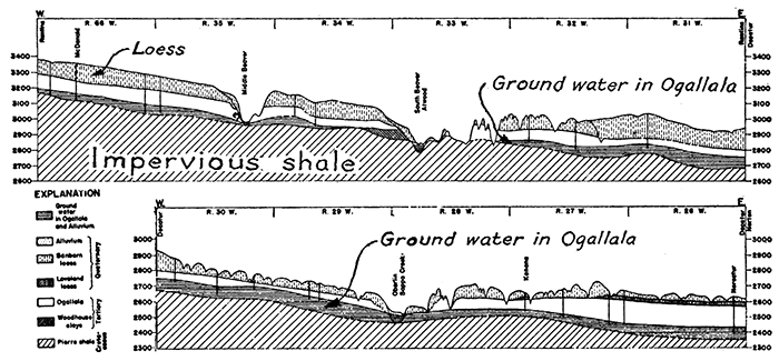
The Tertiary deposits of western Kansas are in general very permeable and they contain an extremely large amount of ground water of excellent quality. Surveys are yet insufficient to show the average quantity of this water and the rate of its movement and recharge. It is safe to conclude, however, that many square miles in the western Kansas region contain at least two billion gallons per square mile.
Clay deposits (Woodhouse) of very local distribution, 20 to 60 feet thick, underlie the Ogallala beds in places. They also belong to the Tertiary system.
Cretaceous system
The uppermost Cretaceous deposits of Kansas consist of dark clayey strata belonging to the Pierre shale. This formation is exposed along the western part of the Smoky Hill river valley and underlies northwestern Kansas, the maximum thickness being about 1,400 feet in Cheyenne county. There are few water-bearing beds in the Pierre formation that will yield good supplies to wells.
The Niobrara chalk, about 500 to 700 feet thick, underlies the Pierre shale. A basal division, called the Fort Hays limestone, about 60 feet thick, consists of moderately hard even-bedded chalky limestone. The remaining part of the chalk consists of soft calcareous shale and soft chalk beds that are relatively impervious to water.
The Codell sandstone, about ten feet thick, underlies the Fort Hays limestone and is a good water-bearing zone that yields water to wells and that is marked along its outcrop by springs in numerous places. Although thin, this sandstone is very persistent.
Beds next below the Codell sandstone comprise the Carlile shale, about 300 feet in thickness. These beds contain no ground water available for wells. The Greenhorn limestone, 75 to 100 feet thick, which underlies the Carlile shale, consists of thin beds of chalky limestone and chalky shale. Ground water is obtainable from joint cracks in the limestone beds, but the Greenhorn is not an important ground-water bearer. The Graneros shale, about 40 to 50 feet thick, below the Greenhorn, consists mostly of clay shale, but contains local lenses of sandstone and sandy shale that may yield some water to wells.
It may be noted that with the exception of the thin Codell sandstone, no part of the Cretaceous beds thus far considered, totaling about 2,500 feet in maximum thickness, can be relied upon to provide ground-water supplies. Accordingly, throughout the broad region of Cretaceous outcrops in north-central and northwestern Kansas, it is necessary, wherever water-bearing Tertiary beds are absent, to rely on surface-water storage or on the ground water collected in the comparatively thin zone of somewhat pervious materials formed by weathering of bedrock. Partly because these difficulties of obtaining water supply have been emphasized by experience in recent drought years, this part of Kansas has lately been the area of greatest activity in construction of farm ponds and other surface reservoirs. As the result of this activity, there has been relatively little distress due to lack of water for stock and domestic use in the north-central Kansas region.
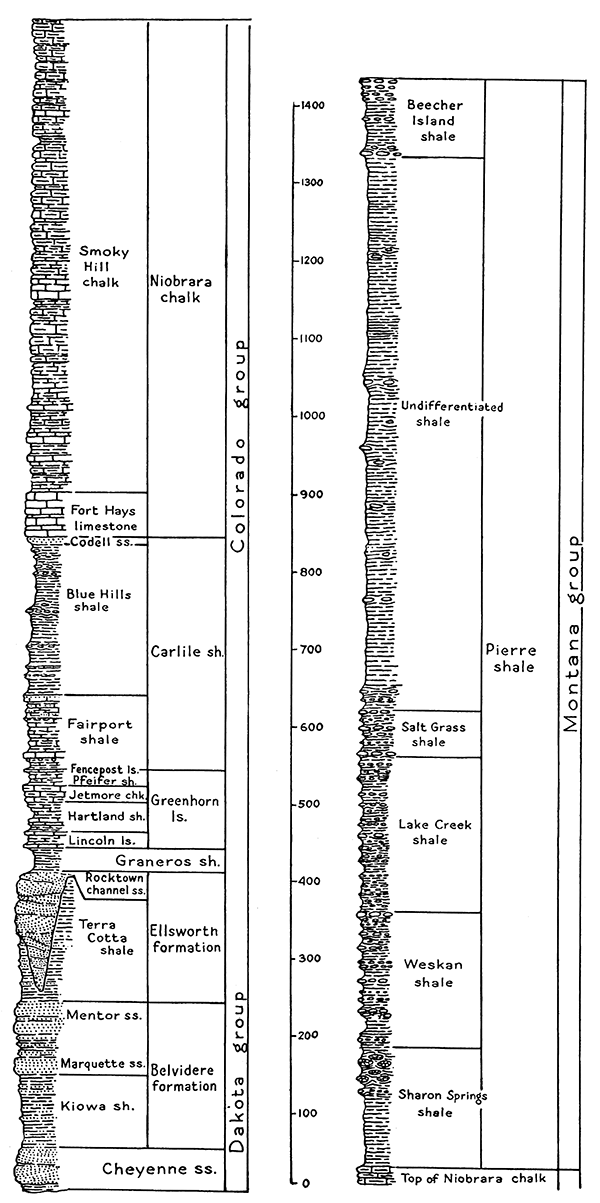
Figure 14--Generalized section of the Cretaceous rocks of Kansas, showing the classification and order of succession of these strata. Sandstone beds of the Dakota group and the thin Codell sandstone, at the base of the Niobrara chalk, are almost the only parts of this system that yield water to wells in Kansas.
The Dakota sandstone comprises the lowest, oldest beds of Cretaceous age that are present in Kansas. (various local Comanchean deposits not being differentiated here from the Dakota). The thickness of these beds, consisting mainly of iron-rich sandstone, ranges from a few feet near the eastern edge of the outcrop area to a maximum of about 600 feet. There are some zones of mottled red and dark-colored shale dividing the sandstone beds. The pervious nature of the sandstone layers makes them good water-bearing rocks. Accordingly, the Dakota sandstone is a formation that supplies large quantities of water to wells and springs in several districts. On the other hand, the occurrence of salt water in parts of this formation renders the Dakota water of certain areas too highly mineralized for domestic or stock use. The Dakota is widely known as an artesian water-bearing formation in the Great Plains region, but it is not an important source of supply in Kansas for relatively deep artesian wells. Wells in parts of Morton, Stanton, and Ford counties in southwestern Kansas penetrate Tertiary strata, but derive water only from the underlying Dakota sandstone.
Permian system
The highest Permian rocks of Kansas are red sandstone and shale beds belonging to the Taloga and Whitehorse formations. These rocks, which have an aggregate total thickness of about 300 feet, underlie most of western Kansas, but are exposed only in parts of Meade, Clark, and Comanche counties. The sandstones contain water sufficient for farm wells in the outcrop area, but where the rocks are deeply buried they contain only salt water.
Below the Whitehorse sandstone are Permian red beds classed as belonging to the Nippewalla group, about 700 feet thick. Deposits of gypsum and thin beds of dolomite occur in parts of the section. Sandstone layers contain fresh water near the outcrop and supply farm wells, but most of the water in the Nippewalla beds is of poor quality, owing to high mineral content. None of the rock can be classed as valuable water-bearing reservoirs.
The next lower division of Permian strata is known as the Sumner group. It comprises the thin Stone Corral dolomite, red beds called the Ninnescah shale, and underneath this, the Wellington shale, which contains the thick Hutchinson salt deposits and many beds of gypsum and anhydrite. The Sumner beds crop out in a relatively broad band with north-south trend extending from Sumner county to Clay and Washington counties. Small quantities of ground water occur in the more pervious strata of the Sumner group, and locally, as near Hillsboro, in Marion County, there are wells yielding as much as seventy gallons a minute that obtain their supply from Sumner rocks. The water is of very poor quality because of its unusually large content of dissolved salt and gypsum. The average total thickness of these rocks is about 1,000 feet.
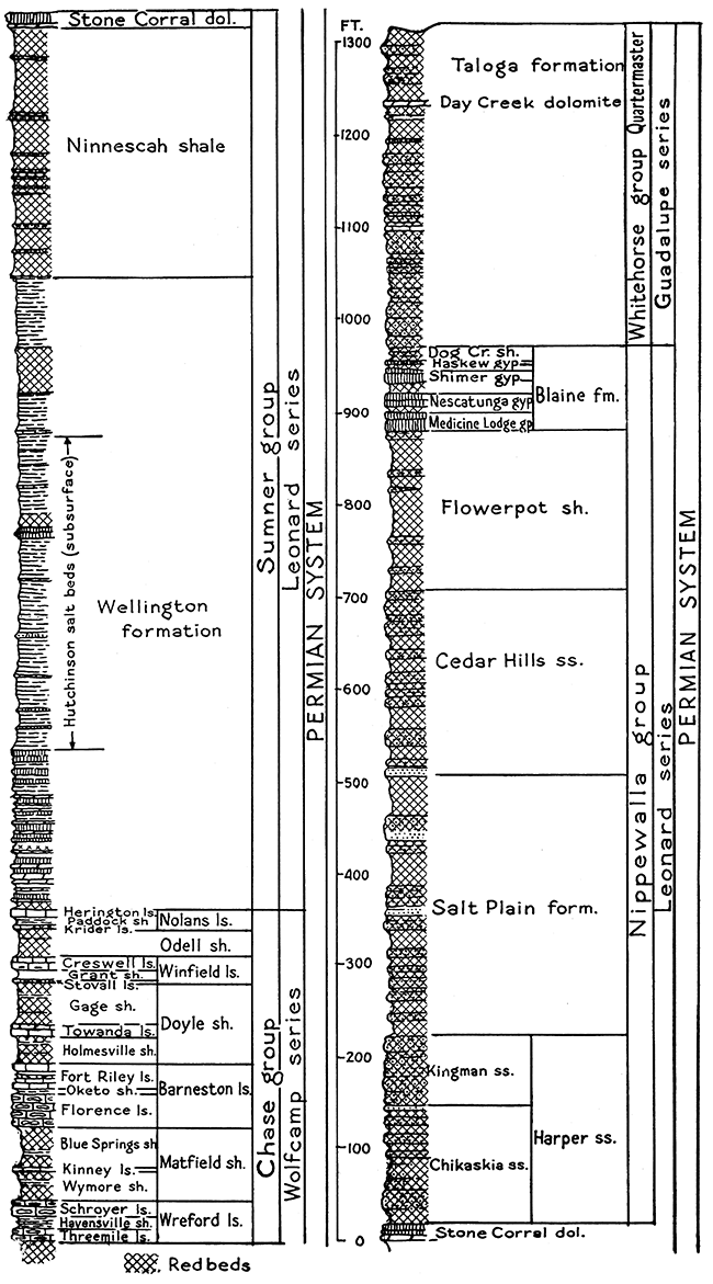
Figure 15--Generalized section of the middle and upper parts of the Permian system in Kansas, based mainly on outcrops in south-central counties. Widespread salt deposits in the middle part of the Wellington formation are not indicated in the section because the salt is penetrated only in deep wells. Ground-water supplies in these rocks are scanty and poor.
The Chase group, which underlies the Sumner beds, has a thickness of 300 to 350 feet. It is distinguished especially by the occurrence of hard flint-bearing limestones that form prominent escarpments along the outcrop. These are the rocks that cap the so-called Flint Hills, or Bluestem belt, that crosses the state from Cowley County to Marshall county. Shale beds that lie between the limestones are not a source of water supply, but several of the limestones, especially those that contain an abundance of flint, yield rather large supplies of water of good quality to shallow wells. Conditions of weathering that facilitate solution of passageways through these beds are most favorable where the rocks underlie broad dip slopes, as between the Flint Hills front in western Greenwood County and the valley of Walnut river in western Butler County, and in extensions of this belt farther south and north. The chief water-bearing formations of this group are the Florence limestone and the Wreford limestone. Somewhat smaller quantities of water are obtainable from the Winfield, Fort Riley, and other limestones.
The Council Grove group, about 300 feet thick, and the Admire group, 100 to 230 feet thick, underlie the Chase beds and form the lowermost part of the Permian system in Kansas. These rocks consist of alternating thin limestones and red or bluish shale beds. Few of the individual rock units exceed ten feet in thickness, and, excepting the Foraker limestone in parts of southern Kansas, none of these strata can be regarded as having any importance as ground-water reservoirs. Almost any of the limestone beds, however, may be sufficiently porous close to their outcrop to permit accumulation in them of small quantities of water that may be recovered by wells. The basal Admire deposits in parts of western Chautauqua, Wabaunsee, Shawnee, and Brown counties consist of thick porous sandstone that constitutes a locally important ground-water reservoir. This is the Indian Cave sandstone, a channel-filling deposit that ranges in thickness from a few inches to 120 feet.
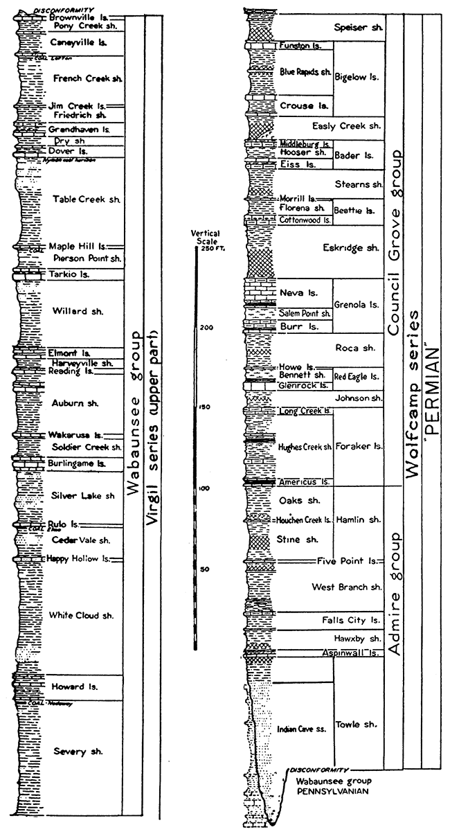
Figure 16--Generalized section of lower Permian and uppermost Carboniferous (upper Pennsylvanian) rocks of Kansas. Some of the limestone formations and some sandstone deposits are good shallow ground-water reservoirs.
Carboniferous system
Outcrops of Pennsylvanian rocks, which comprise the upper part of the Carboniferous system, occupy the eastern one-third of Kansas, lying beneath Permian rocks and cropping out east of them. They consist of alternating thin limestone, shale, and sandstone beds, and at some horizons, thin coal beds. Broadly speaking, these rocks are deficient as ground-water reservoirs, but water derived from Pennsylvanian bedrocks is entirely sufficient in most places to supply farm-water needs.
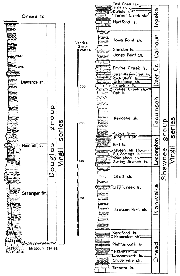
Figure 17--Generalized section of Pennsylvanian rocks belonging to the middle and lower part of the Virgil series in Kansas. The best ground-water supplies occur in sandstone beds of the Douglas group.
The upper 1,000 feet of Pennsylvanian rocks consists of the Virgil series. Few of the upper Virgil limestones are more than five feet thick, but on dip slopes where there are adequate catchment areas, the Brownville, Dover, Tarkio, Reading, Burlingame, and Howard limestones may be water-bearing. The location of the outcrop of these individual units is shown on the detailed geological map of Kansas, published by the Survey (1937). In addition to the limestones, there are sandstones at several horizons that are reliable water-bearing strata, but fresh water is confined to the near-outcrop portions of their extent.
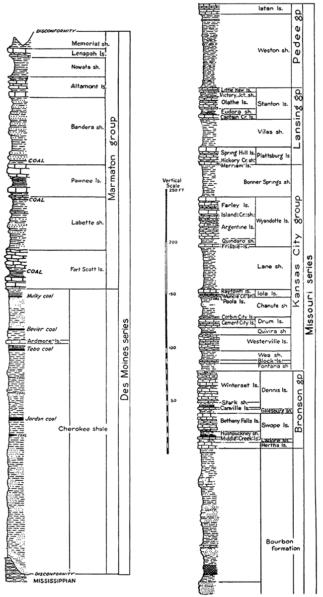
Figure 18--Generalized section of Pennsylvanian rocks belonging to the Missouri and Des Moines series in Kansas.
The middle Virgil beds, known as the Shawnee group, are characterized by greater prominence of limestone strata. Conditions along the outcrop belt are somewhat similar to those in the Chase group of the Permian, except that these Pennsylvanian rocks are less cherty and their content of water is generally less than that of the Permian beds. The best places for water development are long dip slopes. Sandstone beds occur in the shale between these limestones and yield water in many places. The chief water-bearing formations in this part of the bedrock section are the Topeka limestone, Deer Creek limestone, Lecompton limestone, Elgin sandstone member of the Kanwaka shale, and Oread limestone. The Shawnee beds have a total thickness of about 350 feet.
The Douglas group, which includes the lowermost Virgil deposits, has a thickness of 200 to 300 feet. This division is characterized especially by the occurrence of fairly thick and widespread sandstone deposits, which contain good supplies of water near the outcrop. Several towns draw their municipal supplies from wells penetrating these sandstone beds. As shown on the state geologic map, the outcrop belt of the Douglas group extends from eastern Leavenworth County to central Chautauqua County.
The Missouri series underlies the Virgil series and crops out just east of it. The total thickness of this division is about 600 feet. It is characterized especially by prominence of numerous limestone beds separated by thin deposits of clayey to somewhat sandy shale. Limestones that are water-bearing on dip slopes near the outcrops include especially the Stanton, Plattsburg, Wyandotte, lola, and Dennis. Local sandstone deposits in the Bourbon formation, at the base of the Missouri series, ere good water containers in areas close to the outcrop.
The lowest main division of the Pennsylvanian rocks in Kansas consists of the Des Moines series, about 400 to 600 feet thick. The outcrop of these rocks lies along the eastern border of the state and is widest near the Oklahoma boundary. The upper part of the Des Moines beds includes alternating limestone and shale beds that are essentially similar to those of the Missouri and higher divisions. The Pawnee and Fort Scott limestones, and, in southern Kansas, the Altamont and Lenepah limestones may collect and yield water in areas where they underlie long dip slopes. The Cherokee shale comprises the lower part of the Des Moines series and includes 400 to 500 feet of beds, mostly shale. In places there are fairly thick sandstones that yield water close to the outcrop. One of the main water-bearing rocks is the Bluejacket sandstone, which crops out just east of Columbus. The water in this sandstone is sufficient to supply small towns as well as numerous farm wells.
Mississippian rocks, which form the lower part of the Carboniferous system, crop out in a few southeastern townships of Cherokee county, but the exposures in western Missouri are extensive. These rocks consist mainly of limestone, and the passageways for water in this rock have been made by solution along joints and bedding planes. Rainfall on the Mississippian outcrop is conducted into subsurface channels and carried down the dip with only moderate increase of dissolved mineral content. Large quantities of ground water are obtained from Mississippian limestones, 400 to 500 feet thick, in wells drilled in Cherokee and Crawford counties.
Ordovician and Cambrian systems
The pre-Carboniferous rocks of a small part of southeastern Kansas contain ground water that is sufficiently low in mineral content to be used for domestic supplies. This water is found chiefly in porous sandstone layers. Wells, 1,000 to 1,700 feet deep, have been drilled in southeastern Kansas cities, such as Columbus, Pittsburg, Girard, and others, finding usable water in the deep formations. The considerable depth of this ground water, and its increased salt and other mineral content in a northwestward direction, limit utilization to a few places in the counties mentioned.
Prev Page--Investigations || Next Page--Regions
Kansas Geological Survey, Geohydrology
Placed on web Dec. 11, 2015; originally published June 25, 1940.
Comments to webadmin@kgs.ku.edu
The URL for this page is http://www.kgs.ku.edu/Publications/Bulletins/27/05_format.html