![]()
Prev Page--Stratigraphy, Kansas City || Next Page--Stratigraphy, Douglas
Stratigraphy, continued
Lansing Group (redefined)
The Lansing Group overlies the Kansas City Group and underlies the Douglas Group. It comprises in ascending order, Plattsburg Limestone, Vilas Shale, Stanton Limestone, Rock Lake Shale, and South Bend Limestone (fig. 1). The latter two units are removed from the Stanton Limestone and raised in rank to formations, but are retained in the Lansing Group.
Plattsburg Limestone (unchanged)
The Plattsburg Limestone overlies the Lane Shale (Bonner Springs Shale Member) and underlies the Vilas Shale (fig. 1). It comprises, in ascending order, the Merriam Limestone Member, Hickory Creek Shale Member, and Spring Hill Limestone Member. Named from Plattsburg, Missouri, by Broadhead (1868), the principal reference section for the Plattsburg Limestone in Kansas is designated above that of the Bonner Springs Shale Member in the K-7 roadcut (SW-SE-NE sec. 29, T. 15 S., R. 23 E.) on the northeast side of Bonner Springs in Wyandotte County (see Heckel et al., 1999, p. 26, Stop A6). A good reference section for southeastern Kansas is in the K-47 roadcut west of Altoona in Wilson County (NW corner sec. 17, T. 29 S., R. 16 E.; see Heckel, 1988, p. 53).
Merriam Limestone Member (unchanged)
The Merriam Limestone Member overlies the Bonner Springs Shale Member of the Lane Shale, and underlies the Hickory Creek Shale Member across eastern Kansas (fig. 1). Named from Merriam in Johnson County, Kansas, by Moore (1932) and defined by Newell (1935), its principal reference section is designated in the same place as that for the Plattsburg Limestone in the K-7 roadcut at Bonner Springs in Wyandotte County. The upper part of the Merriam Limestone Member is typically 1-2 ft (0.3-0.6 m) of laterally persistent skeletal calcilutite. The lower part is locally up to 9 ft (2.7 m) of lenticular skeletal to oolitic and conglomeratic calcarenite, developed at various places, mostly in northeastern Kansas.
Hickory Creek Shale Member (unchanged)
The Hickory Creek Shale Member overlies the Merriam Limestone Member and underlies the Spring Hill Limestone Member across eastern Kansas (fig. 1). Named by Moore (1932) and defined by Newell (1935) from exposures near Hickory Creek in eastern Franklin County, its principal reference section is designated on the south side of K-68 just east of the bridge over Hickory Creek (NE corner of NW sec. 32, T. 16 S., R. 21 E.). The Hickory Creek generally ranges from 0.5 to 2 ft (0.2-0.6 m) of fossiliferous gray to dark-gray shale in northeastern Kansas, thickening southward to 5 ft (1.5 m) at the Plattsburg Limestone reference section along K-47 in Wilson County and locally to 40 ft (12 m) in northern Montgomery County. Southward, the Hickory Creek Shale Member is identified near the middle of the Wann Formation of northern Oklahoma.
Spring Hill Limestone Member (unchanged)
The Spring Hill Limestone Member overlies the Hickory Creek Shale Member and underlies the Vilas Shale (fig. 1). Named from Spring Hill in southern Johnson County by Moore (1932) and defined by Newell (1935), its incomplete type section in a railroad cut (SE corner of sec. 14, T. 15 S., R. 23 E.) on the east side of town is supplemented by a principal reference section along the east side of US-169 (near center S line SE-SE sec. 10, T. 15 S., R. 23 E.) on the northwest side of town. The Spring Hill Limestone Member averages 15 ft (4.5 m) thick and consists generally of skeletal calcilutite overlain by skeletal to oolitic calcarenite in northeastern Kansas. It is developed southward largely as two distinct phylloid algal mound complexes up to 45 ft (13.5 m) thick in Anderson County and up to 70 ft (21 m) thick in southern Wilson County (Heckel and Cocke, 1969). It consists of thinner shalier calcilutite containing conspicuous calcisponges between the two mound complexes and southward toward the Oklahoma border.
Vilas Shale (unchanged)
The Vilas Shale overlies the Plattsburg Limestone (Spring Hill Limestone Member) and underlies the Stanton Limestone (Captain Creek Limestone Member) (fig. 1). It was named by Adams (1898) from Vilas in Wilson County, where it is about 100 ft (30 m) of gray micaceous sparsely fossiliferous shale. The principal reference section is designated about 6 mi (10 km) to the southwest along US-75 (west line SW sec. 22, T. 28 S., R. 16 E.), 4 mi (7 km) north of Altoona. A completely exposed reference section is along K-47 above that of the Plattsburg Limestone (near NE corner sec. 18, T. 29 S., R. 16 E.) just west of Altoona, where the Vilas Shale is only 25 ft (7.5 m) thick. It thins further to 1 ft (0.3 m) above the thickest parts of the underlying Spring Hill mound complexes in both Wilson and Anderson counties. It then thickens again southward and merges with the upper part of the Wann Formation in northern Oklahoma. The Vilas Shale ranges from 5 to 30 ft (1.5-9 m) thick in northeastern Kansas, where it contains mudstone, thin unfossiliferous earthy limestones, and local sandstone beds in gray sandy shale.
Stanton Limestone (revised)
The Stanton Limestone overlies the Vilas Shale and is now recognized to underlie the Rock Lake Shale across eastern Kansas (figs. 1, 33). The Rock Lake Shale and South Bend Limestone, once considered its upper two members, are now removed from the Stanton Limestone and raised in rank to separate formations. This is because the South Bend Limestone is now itself subdivided into members, and the Rock Lake Shale consists of deposits that represent widespread subaerial exposure, making the two units depositionally distinct from the remaining underlying members. The Stanton Limestone now comprises only three members, in ascending order, Captain Creek Limestone Member, Eudora Shale Member, and Stoner Limestone Member. The upper boundary of the Stanton Limestone is now the upper contact of the Stoner Limestone (or its equi valent named beds to the south), with mudstone, sandstone, or shale of the overlying Rock Lake Shale.
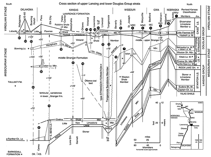
Figure 33--Correlation cross section of upper Missourian and lower Virgilian strata (upper Lansing and lower Douglas Groups) across eastern Kansas from Nebraska, Iowa, and Missouri to northern Oklahoma, showing classification of members of South Bend Limestone and Cass Limestone in Nebraska (as recently emended by R. R. Burchett of Nebraska Geological Survey, personal communication, 1996), and their recognition and correlation into Kansas. Names Nehawka and Plattford are Nebraska names that are not used in Kansas because they are exactly equivalent to names Iatan and Stranger, respectively. Datum is top of Haskell Limstone Member; secondary datum is top of Little Kaw Limestone Member, with thickness between datums based on that in section 11. Symbols are same as on fig. 2, with abundant conodonts represented by tailed diamond symbols and fossil-rich shales represented by narrow vertical lines. Numbers preceded by + on vertical section represent footage omitted from diagram because of space considerations. Missourian-Virgilian Stage boundary is shown above base of Haskell Limestone Member, the most appropriate position based on current conodont biostratigraphic information (Boardman et al., 1989; Barrick et al., 1995; Heckel et al., 1999, p. 63; Heckel, 2002). Locations of measured sections indicated by numbers are given in Appendix. [An Acrobat PDF version of this figure is available.]
The Stanton Limestone was named by Swallow and Hawn (1865) from Stanton in western Miami County. Newell (1935) pragmatically resolved a problem of miscorrelation of the original type Stanton by retaining the name for the unit to which it had become commonly applied (see comment under the first guideline in the introduction). Shortly thereafter, Moore (1936) designated typical exposures in roadcuts near SE corner of sec. 3, T. 13 S., R 21 E. in eastern Douglas County about 25 mi (40 km) to the north. A better exposure (about 2.5 mi/4 km eastward) of the complete Stanton Limestone as now recognized is designated as its principal reference section, along the westbound onramp from Edgerton Road to K-10 in westernmost Johnson County (NE-SE-SE sec. 36, T. 12 S., R. 21 E.). The Stanton Limestone averages between 25 and 35 ft (7.5-10.5 m) in thickness in its type region of northeastern Kansas. It thickens steadily southward across southeastern Kansas to 95 ft (28.5 m) at a nearly completely exposed reference section in the roadcut west of the Elk City Dam (from W half of NE to SE-NW sec. 7, T. 32 S., R. 15 E.) in central Montgomery County. Here most of the thickening occurs as phylloid algal mound facies in both limestone members (Heckel and Cocke, 1969). From here it thins southward to about 20 ft (6 m) of mainly shale with thin siltstone and limestone beds (Heckel, 1975a) in southern Montgomery County. The Stanton Limestone is equivalent to part of the Barnsdall Formation of northern Oklahoma (see fig. 33).
Captain Creek Limestone Member (new beds recognized)
The Captain Creek Limestone Member overlies the Vilas Shale and underlies the Eudora Shale Member across eastern Kansas (fig. 1). Named by Newell (1935) from Captain Creek east of Eudora in eastern Douglas County, with a type locality designated by Moore (1936), its principal reference section is designated nearby, along a gravel road just north of K-10 (SE-SE-SW sec. 3, T. 13 S., R. 21 E.) about 2.5 mi (4 km) southwest of that for the Stanton Limestone. The Captain Creek is about 5-8 ft (1.5-2.4 m) of skeletal calcilutite in northeastern Kansas, thickening steadily southward to 50 ft (15 m) of largely phylloid algal mound facies in central Montgomery County (Heckel and Cocke, 1969). Southward it thins to 1-2 ft (0.3-0.6 m) of yellow-weathering sponge-rich skeletal calcilutite (Heckel, 1975a).
The Benedict limestone bed is a distinctive bed at the base of the Captain Creek in Wilson, Woodson, and Allen counties, named by Heckel (I975b) from Benedict in central Wilson County. It is 4 ft (1.2 m) of dense fossiliferous oolitic calcarenite overlain by 2 ft (0.6 m) of shale at its type section along the road northeast of town (SE-NE-NE-NE sec. 10, T. 28 S., R. 15 E.). It contains large stromatolite heads and lenses of brachiopod-bearing calcarenite to the northeast, and red-algal-dominated calcilutite beds southward. These latter beds are well exposed above greatly thinned Vilas Shale (above the thick Spring Hill algal-mound complex in the Plattsburg Limestone) along the K-96 roadcut west of Neodesha (SE-SW sec. 23, T. 30 S., R. 15 E.).
The Tyro oolite bed forms the south end of the Captain Creek Limestone Member below the southward-thinning sponge-rich calcilutite facies in southern Montgomery County. Named by Heckel (1975a), it is at least 15 ft (4.5 m) of oolite at its type section in an old quarry (NW-SW-SE sec. 30, T. 34 S., R. 15 E.), 1 mi (1.6 km) northeast of Tyro. From here it thins both northward across T. 34 S., and southward into Oklahoma.
Eudora Shale Member (unchanged)
The Eudora Shale Member overlies the Captain Creek Limestone Member and underlies the Stoner Limestone Member (figs. 1,33). Named by Condra (1930) from Eudora in eastern Douglas County, the principal reference section is just above that of the Captain Creek Limestone Member along the gravel road north of K-10 (SE-SE-SW sec. 3, T. 13 S., R. 21 E.), just east of Eudora. The Eudora is 5-8 ft (1.5-2.4 m) of gray shale with black phosphatic shale in the middle in northeastern Kansas, thinning to less than a foot of gray phosphatic shale in east-central Kansas. It thickens to up to 50 ft (15 m) of fossiliferous shale with the thin black phosphatic facies at the base in central Montgomery County, just south of the Captain Creek algal-mound complex. In this area, its upper boundary is the upper contact of shale with siltstone or limestone beds classified with the overlying Stoner Limestone Member. The Eudora Shale Member then thins generally to about 20 ft (6 m) in southern Montgomery County, and locally to 1 ft (0.3 m) above the type Tyro oolite bed in the Tyro quarry, where it is abruptly overlain by conglomeratic sandstone at the base of the Rock Lake Shale.
Stoner Limestone Member (new beds recognized)
The Stoner Limestone Member overlies the Eudora Shale Member and underlies the Rock Lake Shale, now recognized as a separate formation (figs. 1, 33). The Stoner Limestone Member was named by Condra (1930) from the Stoner farm near South Bend, in Cass County, Nebraska. Its principal reference section in Kansas is the same as that for the entire Stanton Limestone along the westbound onramp from Edgerton Road to K-10 (NE-SE-SE sec. 36, T. 12 S., R. 21 E.) in western Johnson County. The Stoner Limestone ranges from 12 to 18 ft (3.6-5.4 m), mainly of skeletal calcilutite locally overlain by skeletal calcarenite and rubbly calcilutite in northeastern Kansas. Southward it reaches as much as 40 ft (12 m) in thickness, including phylloid algal facies, in northern Montgomery County before grading southward into a succession of marine shale, siltstone, and limestone, in which several named beds are recognized.
The Timber Hill siltstone bed, 2-4 ft (0.6-1.2 m) thick, overlies the Eudora Shale Member and underlies the Rock Lake Shale (and the Rutland limestone bed southward) in west-central Montgomery County. It was named by Heckel (197 5a) from a roadcut (near center W line NW sec. 25, T. 32 S., R. 14 E.) on the east side of Timber Hill, where it is hard calcareous siltstone. From here it extends southward to cap Walker Mound in NE sec. 5, T. 33 S., R. 15 E., where it contains sparse brachiopods.
The Rutland limestone bed overlies the Timber Hill siltstone bed, and underlies the Rock Lake Shale in west-central Montgomery County. It was named by Heckel (1975a) from a quarry in Rutland Township (NE corner sec. 2, T. 33 S., R. 14 E.), where it is up to 8 ft (2.4 m) of orange-brown-weathering, abraded-grain skeletal calcarenite (mostly grainstone), which appears to be equivalent to the top of the Stoner Limestone Member. The Rutland bed thins and extends southward to sec. 12, T. 33 S., R. 14 E.
The Bolton limestone bed overlies the Eudora Shale Member and underlies the Rock Lake Shale in southern T. 33 S. and northern T. 34 S. in southern Montgomery County. Named by Heckel (1975a) from a railroad cut (center S half NW-NW sec. 36, T. 33 S., R. 14 E.) southwest of Bolton, it is 1-4 ft (0.3-1.2 m) of argillaceous skeletal calcarenite (mostly packstone), which appears to be equivalent to the lower part of the Stoner Limestone Member.
Rock Lake Shale (raised in rank)
The Rock Lake Shale overlies the revised Stanton Limestone (Stoner Limestone Member) and underlies the revised South Bend Limestone (Little Kaw Limestone Member) across eastern Kansas (figs. 1, 33). It is removed from the Stanton Limestone and elevated to the rank of formation because it comprises mainly terrestrial deposits that represent widespread exposure and disconformity after the close of a major cycle of marine deposition, like many of the shale formations (e.g., Vilas, Chanute, Nellie Bly, Galesburg) lower in the succession. Named from Rock Lake in Sarpy County, Nebraska, by Condra (1927), its principal reference section in Kansas is a roadcut on the northeast side of K-7 (center west line NW sec. 8, T. 11 S., R. 23 E.) just south of US-40 (fig. 34) and about 3 mi (5 km) north of Bonner Springs in western Wyandotte County. Here it is 6 ft (1.8 m) of gray mudstone to micaceous shale with thin sandstone beds (fig. 35). The Rock Lake Shale ranges from 1 to 3 ft (0.3--0.9 m) of gray mudstone up to 15 and locally 50 ft (4.5-15 m) of sandstone-dominated interval across most of eastern Kansas. Sandstones in the Rock Lake generally are friable, noncalcareous, often reddish-colored, and unfossiliferous, which distinguishes them from the hard calcareous, fossiliferous, grayer, and locally conglomeratic sandstones that occur at places in the base of the overlying South Bend Limestone. The Rock Lake Shale thickens southward to perhaps 150 ft (45 m) of sandstone and sandy shale, with local thin oolitic sandy limestone zones, in southern Montgomery County above the named beds at the south end of the Stoner Limestone Member. One of the sandstones is traceable enough from southern T. 32 S. across T. 33 S. to be termed informally the Onion Creek sandstone body by Heckel (1975a) after exposures along Onion Creek, particularly along the road between sections 14 and 15 and 22 and 23, T. 33 S., R. 14 E.
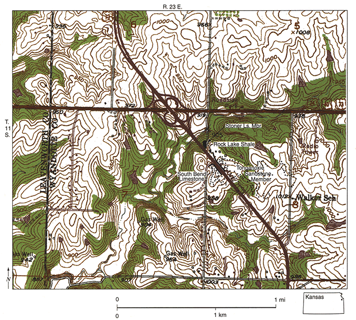
Figure 34--Map of part of 1950 (photorevised 1975) Bonner Springs, Kansas, 7 1/2-minute quadrangle, showing locations of principal reference sections of Rock Lake Shale and South Bend Limestone anti its component Gretna Shale Member in Kansas, and type section of its component Little Kaw Limestone Member, in roadcuts along K-7 just south of US-40 in Wyandotte County.
South Bend Limestone (raised in rank, revised, and subdivided)
The South Bend Limestone overlies the Rock Lake Shale and underlies the Stranger Formation across eastern Kansas (figs. 1, 33). It is removed from the Stanton Limestone and raised in rank to formation because it is now subdivided into members representing a distinctly later cycle of marine deposition that is separated from the Stanton Limestone by the terrestrial deposits of the Rock Lake Shale. The South Bend Limestone has been subdivided by Pabian and Strimple (1993) into three named units in its type area in Nebraska, in ascending order, Little Kaw Limestone, Gretna Shale, and Kitaki Limestone (figs. 1, 33), homologous to those of other marine limestone formations in Kansas. The Little Kaw Limestone and Gretna Shale are exposed and recognized as members in Kansas (fig. 35), but the Kitaki Limestone is not known south of core MNC in northern Missouri (fig. 33). Named from South Bend in Cass County, Nebraska, by Condra and Bengston (1915), the principal reference section of the South Bend Limestone in Kansas is a roadcut along the southwest side of K-7 (NW-SW-NW sec. 8, T. 11 S., R. 23 E.) essentially across the highway from that of the Rock Lake Shale just south of US-40, about 3 mi (5 km) north of Bonner Springs in Wyandotte County (figs. 34 and 33, section 10). An excellent reference section for the South Bend Limestone in southeastern Kansas is exposed at the top of the roadcut west of Elk City Dam (SW-SE-NW sec. 7, T. 32 S., R.15 E.), northwest of Independence in Montgomery County (fig. 33, section 19). The boundaries of this formation are described under its component members.
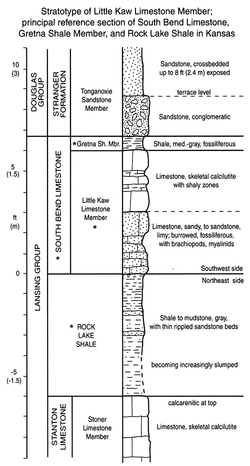
Figure 35--Measured section of Little Kaw Limestone Member stratotype, and principal reference section of South Bend Limestone and Gretna Shale Member in Kansas, in roadcut on southwest side of K-7 just south of US-40, in NW-SW-NW sec. 8, T. 11 S, R. 23 E. (fig. 34), and of Rock Lake Shale in Kansas, in roadcut on northeast side of K-7 just to north (near center W line NW sec. 8, same township), Wyandotte County, Kansas.
Little Kaw Limestone Member (reinstated)
The Little Kaw Limestone Member overlies the Rock Lake Shale and underlies the Gretna Shale Member across eastern Kansas (figs. 1, 33). The name Little Kaw was derived by Newell (1935) from Little Kaw Creek, 2 mi (3 km) southwest of Bonner Springs in southern Leavenworth County, and applied to the unit believed for most of the time since then to represent the entire South Bend Limestone of Nebraska. The name was abandoned by Moore (1949) when he accepted its equivalence to the earlier named South Bend Limestone. Because the type South Bend in Nebraska is now known to include two younger units as well (fig. 33), the name Little Kaw is reinstated to apply to only the basal limestone unit of the South Bend. comprising exactly the same strata to which it was originally applied. The type section of the Little Kaw Limestone Member is designated near the "typical exposures" given in Moore (1936), at the much better exposed principal reference section for the entire South Bend Limestone in Kansas (fig. 33, section 10) in the roadcut at the intersection on the west side of K-7 (NW-SW-NW sec. 8, T. 11 S., R. 23 E.), just south of US-40 (fig. 34) and 3 mi (5 km) north of Bonner Springs. Here the Little Kaw is 6 ft (1.8 m) thick, comprising 3 ft (0.9 m) of skeletal calcilutite above 3 ft (0.9 m) of sandy limestone to fossiliferous calcareous sandstone (fig. 35). The Little Kaw Limestone Member is generally 2-4 ft (0.6-1.2 m) of skeletal calcilutite with various amounts of fossiliferous to conglomeratic sandstone at the base across most of Kansas. Locally, it contains a conspicuous biota dominated by derbyiid and meekellid brachiopods or myalinid clams. Its lower boundary is typically sharp above the mudstone and shale of the underlying Rock Lake Shale, but locally appears more diffuse above sandstone in the Rock Lake. Here, however, closer inspection allows the hard calcareous fossiliferous sandstone of the basal Little Kaw to be distinguished from the more friable unfossiliferous sandstones of the Rock Lake. The upper boundary with the overlying Gretna Shale Member is sharp. The Little Kaw Limestone Member thickens to 20 ft (6 m) at the reference section west of Elk City Dam (fig. 33, section 19), and includes phylloid algal facies up to 25 ft (7.5 m) nearby in central Montgomery County (Heckel and Cocke, 1969). Southward, it thins to 4-5 ft (1.2-1.5 m) of yellowish-weathering skeletal calcilutite with conspicuous calcisponges in southwestern Montgomery County (Heckel, 1975a).
Gretna Shale Member (now recognized in Kansas)
The Gretna Shale Member overlies the Little Kaw Limestone Member and underlies the Stranger Formation across eastern Kansas (fig. 1). The name Gretna Shale was applied by Pabian and Strimple (1993) from Gretna in Sarpy County, Nebraska, to the middle shale unit of the South Bend Limestone in its type area. Its fossiliferous, conodont-rich nature and its consistent position above the Little Kaw Limestone Member makes it easy to trace into Kansas (fig. 33). Its principal reference section in Kansas is the same as that for the entire South Bend and the type section of the Little Kaw Limestone Member in the K-7 roadcut just south of US-40 (figs. 34 and 33, section 10). The Gretna Shale is generally about 1 ft (0.3 m) of fossiliferous shale with crinoids, brachiopods, bryozoans, and conodonts in the few places where it is exposed across eastern Kansas. Its upper boundary is sharp where it is overlain by limestone (as in Nebraska) or by sandstone (as at the principal reference section, fig. 35), but is more diffuse where overlain by sandy shale or siltstone of the Stranger Formation. Although it would be reasonably mapped with the Stranger in those places, its thinness would render it merely the line between the South Bend and Stranger formations on any map. The Gretna Shale Member is partly exposed above the Little Kaw Limestone Member in a US-59 roadcut 5 mi (8 km) north of Lone Elm (E line, north of SE corner of sec. 6, T. 22 S., R. 20 E.) in Anderson County (fig. 33, section 17). It is well exposed as 0.3 ft (10 em) of fossiliferous shale between the top of the Little Kaw Limestone and thin argillaceous sandstone beds at the base of the Stranger Formation in the reference roadcut west of Elk City Dam (SW-SE-NW sec. 7, T. 32 S., R. 15 E.) in northwestern Montgomery County (fig. 33, section 19). Southward the Gretna thickens above the thinning Little Kaw Limestone Member to several feet of fossiliferous shale in southwestern Montgomery and extreme southeastern Chautauqua County (fig. 33, section 21).
Prev Page--Stratigraphy, Kansas City || Next Page--Stratigraphy, Douglas
Kansas Geological Survey, Geology
Placed on web Oct. 20, 2014; originally published 2002.
Comments to webadmin@kgs.ku.edu
The URL for this page is http://www.kgs.ku.edu/Publications/Bulletins/246/06_lans.html