![]()
Prev Page--Stratigraphy, Pleasanton || Next Page--Stratigraphy, Kansas City
Stratigraphy, continued
Coffeyville Group (now recognized in Kansas)
The Coffeyville Formation was named by Schrader and Haworth (1905) from Coffeyville, Kansas. The name has been used mainly in Oklahoma (Oakes, 1940) to encompass the strata from the top of the Checkerboard Limestone to the base of the Hogshooter (Dennis) Limestone. It is now extended as a group into southern Kansas because of its usefulness in delineating the dominantly siliciclastic stratigraphic interval equivalent to the top of the Pleasanton Group (Shale Hill Formation) and base of the Kansas City Group (all of the Bronson Subgroup except the Dennis Limestone). The Coffeyville Group is defined here to include, in ascending order, the Tacket Formation (revised), Ladore Shale, Mound Valley Limestone (reinstated), and Galesburg Shale (figs. 1, 2). The group is restricted to an area in southern Kansas (Labette and southern Neosho counties) where the upper part of the Pleasanton Group (Shale Hill Formation) thins conspicuously and most of the overlying Bronson Subgroup of the Kansas City Group is predominantly siliciclastic. Locally thick sandstone bodies occur in the Galesburg Shale between the Mound Valley Limestone below and the Dennis (Hogshooter) Limestone above, and this part of the group is well exposed in the bluffs along the Verdigris River north of Coffeyville. The most accessible exposure for a reference section of the upper part of the group is in a shale pit at the south end of the bluffs (SW-NW sec. 26, T. 34 S, R. 16 E.). Formations above the Tacket Formation are discussed under the Bronson Subgroup of the Kansas City Group.
Tacket Formation (revised)
The Tacket Formation overlies the Hepler Formation and underlies the Ladore Shale in southernmost Kansas. It is revised to include all the dark-shale-dominated strata in southern Kansas equivalent to the stratigraphic interval extending from the top of the Checkerboard Limestone Member or the South Mound Shale Member of the Hepler Formation (Pleasanton Group) up through the Bethany Falls Limestone Member of the Swope Limestone (figs. 1, 2). The Tacket Formation was named by Jewett et al. (1965) from a type exposure about 1 mi (1.6 km) southeast of Tackett (sic) Mound between Parsons and Mound Valley in Labette County, to comprise the strata between the Checkerboard Limestone and the Hertha Limestone as it was then correlated, and it was regarded as the upper formation of the Pleasanton Group. Recent field work initiated as a result of biostratigraphic observations by Pavlicek (1986) has shown that the Tacket Formation as mapped in its type area encompasses strata equivalent to not only the Shale Hill Formation of the Pleasanton Group, but also to the overlying Hertha, Elm Branch, and Swope formations of the Bronson Subgroup of the Kansas City Group as well (see fig. 2). The main reason for this revision was the discovery that the Tacket Formation as defined in its type area includes two phosphatic black shale units, which are the southerly extensions of similar facies in the Mound City Shale Member of the Hertha Limestone and the Hushpuckney Shale Member of the Swope Limestone. Therefore the Tacket Formation is mostly younger than any part of the Pleasanton Group (even as revised upward herein) within which it was originally included.
Figure 9--Map of part of Xenia, Kansas, 7 1/2-minute quadrangle, showing location of principal reference section of Exline Limestone Member in Kansas (discovered by A. P. Bennison), along with overlying units in north road ditch east of Turkey Creek, 3 mi (S km) northeast of Uniontown. Bourbon County. Kansas.
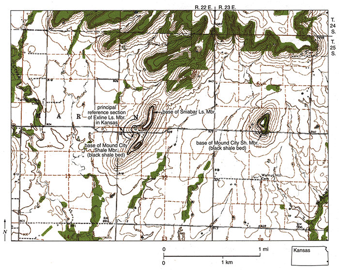
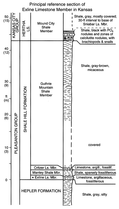
Figure 10--Measured section of principal reference section of Exline Limestone Member in Kansas and overlying units in road ditch east of Turkey Creek, along center of N half of NW-NW sec. 12, T. 25 S., R. 22 E. (fig. 9), 3 mi (5 km) northeast of Uniontown, Bourbon County, Kansas.
Because the type exposure of the Tacket Formation designated by Jewett et al. (1965, p. 7-8) along the west side of sec. 17. T. 32 S., R. 19 E. is now very poorly exposed (and probably equivalent to only the Upper Shale member), a neostratotype is established on the northeast side of Tackett Mound, from near the NE corner of S W sec. 7, into the adjacent creek bank in SW-SW-NE sec. 7, T. 32 S., R. 19 E. (fig. 13) in Labette County, Kansas. The Tacket interval consists of about 40 ft (12 m) of dark-gray to black shale with thin limestone beds and nodule horizons and includes the thin Bethany Falls Limestone Member at the top (fig. 14). The lower boundary is the contact between dark fossiliferous shale (with local argillaceous limestone lenses that resemble the Exline Limestone Member) above gray silty shale, mudstone, or sandstone at the top of the South Mound Shale Member of the Hepler Formation; southward it is the contact between similar dark shale and the purer limestone at the top of the Checkerboard Limestone Member, as is seen generally in exposures in northern Oklahoma. The upper boundary is the abrupt contact between the Bethany Falls Limestone Member and gray overlying Ladore Shale. Northward from central Neosho County, the Tacket interval thickens as the various units to which it is equivalent (Shale Hill Formation, Hertha Limestone, Elm Branch Shale, Swope Limestone) become better differentiated and thicken (fig. 2) and are more readily classified as members and formations in the Pleasanton and Kansas City Groups. Southward the Tacket Formation can be traced at the base of the Coffeyville interval to the area south of Tulsa, Oklahoma.
As revised, the Tacket Formation comprises three informal members and one formal member, in ascending order: Lower Shale member, Middle Limestone member, Upper Shale member, and Bethany Falls Limestone Member (fig. 1). The type sections of all three informal members are at the type section for the entire formation at Tackett Mound (fig. 14). The Lower Shale member is 9 ft (2.7 m) of dark-gray shale at the type section with a zone of large limestone nodules overlain by black phosphatic shale in the middle, which is the lateral equivalent of the black shale bed at the base of the Mound City Shale Member of the Hertha Limestone northward. Local lenses of skeletal limestone at the base seem to represent the Exline Member of the Shale Hill Formation, and the 3 ft (0.9 m) of dark-gray shale above this represent the southern featheredge of the upper three members of the Shale Hill Formation. The Middle Limestone member is 1 ft (0.3 m) of dark-gray, hard, argillaceous fossiliferous calcilutite at the type section, which is largely equivalent to the Sniabar Limestone Member of the Hertha Limestone. This member can be traced throughout the entire extent of the Tacket Formation, averaging about 0.5 ft (15 cm) in thickness and separating the two shale members with abrupt lithic boundaries. The Upper Shale member is 27 ft (8 m) of dark-gray shale at the type section, with several zones of essentially unfossiliferous limestone nodules and beds, and, in the middle of the lower half, a bed of black phosphatic shale, which is the lateral equivalent of the same facies of the Hushpuckney Shale Member of the Swope Limestone. This member is the most commonly exposed part of the Tacket Formation in southern Kansas, and is easily accessible along the road south of Wilsonton Cemetery (along Eline SE sec. 17, T. 32 S., R. 19 E.) just to the east (fig. 13). The Bethany Falls Limestone Member (see later section), extending southward from eastern Kansas, is 4 ft (1.2 m) of pale-orange-weathering fossiliferous limestone at the Tacket type section. It is classified as the upper member of the Tacket Formation south of the disappearance of the Middle Creek Limestone Member in central Neosho County where the Swope Limestone (which contains these two members northward) becomes undefined at the base. Thus, the Tacket Formation is the exact equivalent of the interval from the base of the Shale Hill Formation through the top of the Swope Limestone of northeastern Kansas.
Prev Page--Stratigraphy, Pleasanton || Next Page--Stratigraphy, Kansas City
Kansas Geological Survey, Geology
Placed on web Oct. 20, 2014; originally published 2002.
Comments to webadmin@kgs.ku.edu
The URL for this page is http://www.kgs.ku.edu/Publications/Bulletins/246/04_coff.html