Previous--Introduction and Overview of the Atlas Papers || Next--Basement Tectonic Configuration in Kansas
Kansas Geological Survey
This article available as an Acrobat PDF file (5.4 Mb).
Booms and busts in the petroleum industry have occurred in Kansas since oil was first produced near Paola in the 1870's. Oil and gas prices are currently low, and as a result, the energy industry in Kansas is depressed, particularly compared to the boom times of the late 1970's. Although petroleum resources are slowly dwindling, approximately 8,500 jobs statewide are still directly involved with its extraction and conveyance (Gerhard, 1992). Over the last decade, annual cash receipts from Kansas oil and gas production equal that of the total annual statewide crop production (Carr, 1994). The energy industry therefore remains an impressive component of the economy of the state, and it will probably continue to be important well into the next century. Just how big the industry will be is difficult to predict because its prosperity largely hinges on mercurial world energy prices and politics. In any event, the future of the industry in Kansas will probably be dominated by small companies, at least with respect to the production of oil. Major companies and large independents still are involved with gas production in the state by virtue of extensive acreage holdings in southwestern Kansas.
The history of petroleum production in Kansas through this century has paralleled the evolution of the science of petroleum geology. At the turn of this century, finding energy resources was principally a process of guesswork, "witching," the knack of drilling wells near seeps, fast-talking promotion, and just plain luck. Although serendipity will always be a part of the process, energy exploration and development are now more systematic and less desultory, involving aspects of structural geology, stratigraphy, well-log interpretation, petrophysical analysis, geophysics, and petroleum engineering.
Various geologic methods have enjoyed their heyday. Structural mapping based on surface geology and topography was important around World War I, when El Dorado, the largest oil field in Kansas, was found along the Nemaha uplift in Butler County. In the following decades, as the more obvious surface structures were explored, subsurface mapping became increasingly important and led to the discovery of many major fields in Kansas. Some of these subsurface data were obtained by drilling grids of shallow core holes, but most data now are based on deeper exploratory well control.
Almost 6 billion barrels of oil have been produced in Kansas (Carr, 1994; fig. 1). Approximately 35% of this oil was from Pennsylvanian rock. Cambrian-Ordovician Arbuckle production, mostly from the Central Kansas uplift, accounts for another 32% of the total production of the state. Mississippian fields, primarily carbonates in the Hugoton and Sedgwick basins, have produced 19% of the oil (Carr, 1994). Cumulative gas production is 29.5 TCF, with the overwhelming percentage (86%) coming from Permian strata (fig. 1).
Figure 1--Cumulative oil and gas production (by interval) compared to annual oil and gas production (from Carr, 1994). Size of circle is proportional to volume of production.
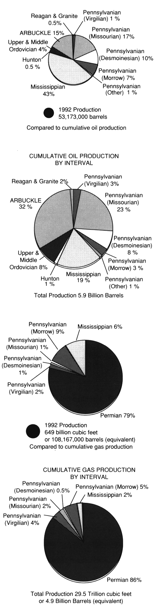
Kansas currently ranks eighth among states in terms of the amount of oil produced annually, and sixth among the states that produce gas (World Oil, 1994). Oil production peaked in 1956 at 124 million bbls/yr. Gas production peaked in 1970 at 920 BCF per year (Oros, 1979). Current oil production is approximately 50 million bbls/yr while gas production is approximately 650 BCF (Carr, 1994). As of 1990, estimated proved reserves for Kansas were 321 million BO and 9,614 BCFG (Gerhard, 1992). Potential future discoveries, however, may prove up to an additional 2.2 billion barrels of recoverable reserves (Gerhard et al., 1994).
Only a cursory outline of the geologic history of Kansas as it relates to petroleum production is provided in this article. More extensive and elaborate summaries are found in Jewett (1954), Merriam (1963), Zeller (1968), Adler et al. (1971), and Newell, Watney, Cheng, and Brownrigg (1987). Capsulated summaries in previous volumes on geophysics in Kansas (Jewett and Merriam, 1959; Newell et al., 1989) also are useful.
Nowhere in Kansas is the cover of sedimentary rocks more than about 9,500 ft (2,850 m) thick. Due to numerous unconformities, this veneer of sedimentary strata in Kansas cumulatively represents perhaps only 15-50% of post-Precambrian time (Merriam, 1963). Unconsolidated Quaternary sediments are confined mostly to present drainage systems and are relatively thin. Pleistocene glacial deposits cover much of northeastern Kansas but much of this unconsolidated strata has been lost to erosion. Nonmarine Pliocene rocks, the Ogallala Formation, blanket the western third of Kansas, effectively masking the underlying stratigraphy and structure.
A thick section of Mesozoic rock, composed predominantly of marine shales, limestones, chalks, and nonmarine deposits of sandstone and shale, covers the western half of Kansas (fig. 2). Most of these strata were deposited in a broad Cretaceous seaway that bisected North America. The eastern shores of this seaway were probably situated in eastern Kansas or western Missouri, but subsequent erosion has removed the Mesozoic strata from these areas.
Figure 2--Generalized pre-Tertiary stratigraphy of Kansas showing approximate thickness of major stratigraphic units (from Jenden et al., 1988). Cenozoic beds are not shown in this diagram.
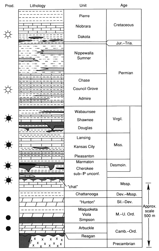
The Pennsylvanian and Permian systems (fig. 2) are the thickest sequences of rock in the state, and they document in their stratigraphic record dozens of cyclothemic inundations of the sea. Thin but laterally persistent units can be traced over large areas of the midcontinent, but significant lateral facies changes can occur as depositional environments change from shallow shelf to deeper basin. Bedded rock salts occur at several levels in the Permian System (Anderson et al., this volume, p. 57).
Rocks representing all pre-Pennsylvanian systems are present in Kansas. These consist mainly of marine limestones and dolomites, alternating with shales and sandstones (fig. 2). The thickest sections of pre-Pennsylvanian rock are found near the centers of the broad intracratonic basins where they have been protected from extensive erosion.
The Precambrian basement in the state consists mainly of granite, quartzite, and schist. Aeromagnetic and gravity studies, combined with drill data and radiometric dating, help define Precambrian tectonic terranes (Lam and Yarger, 1989; Yarger, 1989). The Midcontinent Rift System, a major late Precambrian tectonic feature, transects the state and contains an assemblage of basaltic flows, intrusives, and arkosic sandstones (Baars, this volume, p. 7; Woelk and Hinze, this volume, p. 22; fig. 3).
Two major positive tectonic elements, the Central Kansas and Nemaha uplifts, are probably manifestations of the Ouachita orogeny on the margin of the craton in Late Mississippian-Early Pennsylvanian time (Merriam, 1963; Baars, this volume, p. 7). These two uplifts also serve to define five basins that partly underlie the state (fig. 3).
Figure 3--Large-scale structural features in Kansas (from Merriam, 1963; Bickford et al., 1981; Yarger, 1983): A--Pre-Desmoinesian-post-Mississippian features; B--Pre-Mississippian-post-Ordovician; C--Post-Cambrian-pre-Middle Ordovician; D--Precambrian.
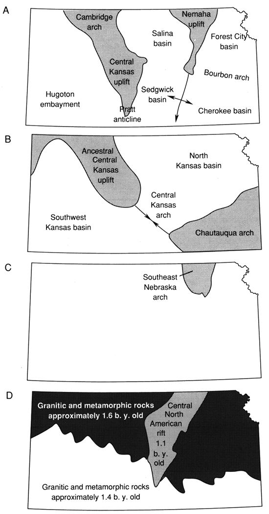
Only the southwestern part of the Forest City basin extends into Kansas. It is bounded on the west by the Nemaha uplift and on the south by the low, indistinct, northwest-southeast-trending Bourbon arch. The basin axis lies close to the Nemaha uplift, hence the basin is asymmetric with a steep, faulted western flank. A production trend paying from lower Paleozoic strata along the axis of the Forest City basin is related to a series of anticlines along the Humboldt fault zone (Merriam, 1963). The Forest City basin, and the Salina basin to the west, are formerly part of the older North Kansas basin (fig. 3). The North Kansas basin was split in Late Mississippian-Early Pennsylvanian time by the rise of the Nemaha uplift.
South of the Bourbon arch in southeastern Kansas is the Cherokee basin, which partly overlies the older pre-Devonian Chautauqua arch. Like the Forest City basin, the present structural axis of the Cherokee basin lies just east of the Nemaha uplift. Numerous stratigraphic traps characterize the venerable fields in the Cherokee basin and eastern flank of the Forest City basin, with production being principally from channel sandstones in the Pennsylvanian Cherokee Group.
The Nemaha uplift separates the Forest City and Cherokee basins from the Salina and Sedgwick basins. The Precambrian core of the Nemaha uplift is within 500 ft (150 m) of the surface near the Nebraska border but plunges to about 4,000 ft (1,200 m) at the Oklahoma border. Several structural culminations lie along its crest and one of these is the locus of the El Dorado field, the most prolific oil field in Kansas. Lower Paleozoic strata have been upturned and truncated by Pennsylvanian strata at several places on the crest of the Nemaha uplift. Faulting is particularly prevalent in the northeastern part of the state where the top of the Precambrian has approximately 2,000 ft (600 m) of vertical offset. In southern Kansas, structural relief is more subdued and in many places Paleozoic beds are folded over the crest. Small-magnitude earthquakes indicate that minor tectonic movement is continuing. The Nemaha uplift extends southward into Oklahoma and provides an element of structural closure for many petroleum fields in that state.
The southern half of the Salina basin underlies much of north-central Kansas. The northern half underlies south-central Nebraska, where it is referred to as the Central Nebraska basin. The Salina basin is asymmetric like the Forest City basin, having a broad eastern flank and relatively steep western flank, but faulting is not evident along the western flank of the Salina basin. Although the axis of this basin is buried to a depth comparable to that in the Forest City basin, no oil production has been found to date along the axis of the Salina basin.
The Sedgwick basin, a shelflike extension of the Anadarko basin of Oklahoma, is roughly symmetrical and plunges southward. It extends across much of south-central Kansas and is separated from the Salina basin to the north by a low, unnamed east-west-trending arch. Oil production in the Sedgwick basin is from several stratigraphic horizons, but Mississippian pay zones dominate. The Pratt anticline, a southward-plunging nose off the Central Kansas uplift, defines the western flank of the Sedgwick basin.
The Central Kansas uplift is referred to as the structural backbone of Kansas. Along its crest, Precambrian rocks are overlain by rocks as young as Pennsylvanian; along its flanks, pre-Pennsylvanian units are upturned, truncated, and overstepped by younger Pennsylvanian strata. The Central Kansas uplift, the Cambridge arch to the northwest, and its northern extension in Nebraska, the Chadron arch, form an arcuate chain of uplifts that are convex to the southwest. The Central Kansas uplift is the most prolific oil province in Kansas, with principal pay zones being the Cambrian-Ordovician Arbuckle Group and the several stacked pays in the cyclothemic carbonates of the Pennsylvanian Lansing-Kansas City Group. This uplift is one of the most densely drilled petroleum provinces in the United States, and seven of the 10 largest fields in Kansas are located on it (Newell, Watney, Cheng, and Brownrigg, 1987). Outpost drilling has extended production of fields on the uplift where many of them have virtually merged. Although field boundaries are still maintained for accounting purposes, if these fields were considered as one entity, a large field having produced approximately a billion barrels of oil could be envisioned--a true giant on par with those in Texas and Oklahoma.
The Hugoton embayment, an extension of the Anadarko basin of Oklahoma, underlies the western third of Kansas. The axis of the embayment plunges generally southeastward, and strata within it thicken down-axis into the Anadarko basin. The greatest thickness of Phanerozoic strata in Kansas occurs in this basin where approximately 9,500 ft (2,850 m) of strata are preserved at the Oklahoma border. Permian strata in this basin account for the majority of gas production in the state, with most coming from carbonate reservoirs of the Chase Group in the giant Hugoton-Panhandle field and nearby smaller gas fields (Adler et al., 1971). Carbonate reservoirs of the Permian Council Grove Group in the Panoma gas field that underlies part of the HugotonPanhandle field are also important (Parham, 1993).
In the future, deeper targets in the Hugoton embayment may take the spotlight as the most important oil exploration area of the state, but venerable producing areas on the Central Kansas uplift also will remain important sources of production. Mississippian strata that now accounts for 43% of the production in the state (Carr, 1994) also will be an exploration target. Most of the larger Mississippian fields in the state are in the Sedgwick basin, but since the 1970's most big Mississippian discoveries have been in the Hugoton embayment. Pennsylvanian strata, principally the Morrow Formation, also hold promise for significant stratigraphic traps in the Hugoton embayment.
Patterns of deformation in Kansas have changed throughout geologic time (fig. 3). Structurally positive areas can become down warped areas, and visa versa. For example, the Nemaha uplift was once the location of the axis of the North Kansas basin. Earlier, the axis of the North Kansas basin was the locus of a broad uplift called the Southeast Nebraska arch. The Cherokee basin in southeastern Kansas overlies part of the earlier Chautauqua arch.
The erosion associated with these uplifts has produced a complex pattern of stratigraphic units that can be expressed by paleogeologic maps, also known as subcrop maps. Petroleum is often associated with traps and porosity developed along unconformities (see Schlee, 1984). For example, porosity can develop by weathering and karstification of rocks beneath unconformities. Porous sandstones can be deposited upon an unconformity by a subsequent transgression of the sea. Unconformities can also act as regional "carrier beds" for petroleum.
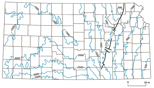
Inasmuch as unconformities may influence both the migration and trapping of petroleum, it is perhaps informative to look at the distribution of petroleum along an unconformity, rather than conventionally noting the stratigraphic unit producing the petroleum (cf., Newell, Watney, Cheng, and Brownrigg, 1987; Carr et al., 1993). In this sense, the basal Pennsylvanian unconformity in Kansas has an enormous amount of petroleum distributed along it. The Cambrian-Ordovician Arbuckle Formation produces oil just below this unconformity at the crest of the prolific Central Kansas uplift, as do several lower Paleozoic formations on the flanks of the uplift (fig. 4). Mississippian "chat," together with "basal Pennsylvanian conglomerate," are also major pay zones along this unconformity, and both of these zones are components of many large stratigraphic traps in the Sedgwick basin and Hugoton embayment. Porosity associated with the basal Pennsylvanian unconformity may have functioned as a carrier bed for petroleum expelled from the deeper part of the Anadarko basin. Many of the traps downdip closer to the Anadarko basin produce gas (fig. 4), whereas updip traps produce oil-a pattern predicted by Gussow (1954) in his principle of differential petroleum migration. Curiously, the Central Kansas uplift appears quite imposing on a subcrop map (fig. 5), but a structure map of the basal Pennsylvanian unconformity (fig. 6) expresses it as only a subdued structural closure in the center of a broad structural low underlying much of the state.
Figure 4--Distribution of petroleum production along the basal Pennsylvanian angular unconformity in Kansas (composited from data in Newell, Watney, Cheng, and Brownrigg, 1987).
Figure 5--Paleogeologic map of units subcropping below the basal Pennsylvanlan unconformity in Kansas (taken from Merriam, 1963; Newell, 1987a; Lambert, 1988).
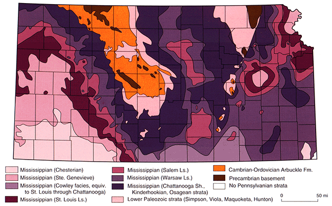
Figure 6--Subsea depth of basal Pennsylvanian unconformity in Kansas (from maps in Merriam, 1963).
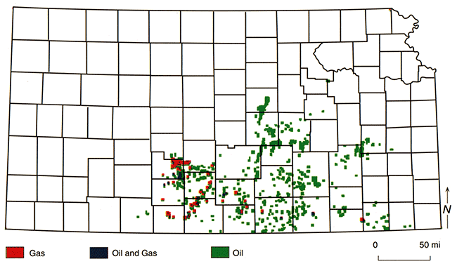
Other major unconformities may also influence the migration and trapping of petroleum. The angular unconformity at the base of the Devonian-Mississippian Chattanooga Shale has much production associated with it, including several stratigraphic traps in central Kansas where the Silurian-Devonian "Hunton" carbonates pinch out beneath it (figs. 7 and 8). Misener sandstone, the erratically distributed transgressive sandstone present immediately above this unconformity, produces from several fields in Kansas and Oklahoma. In addition, the Chattanooga Shale is a major source rock in Oklahoma (Lambert, 1992), and hydrocarbons expulsed from it could migrate very efficiently into porous zones present along the unconformity at its base.
Figure 7--Paleogeologic map of units subcropplng below the Chattanooga Shale in Kansas (taken from Merriam, 1963; Newell, 1987b).
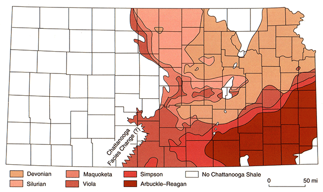
Figure 8--Distribution of petroleum production along the angular unconformity at the base of the Chattanooga Shale in Kansas (composited from data in Newell, Watney, Cheng, and Brownrigg, 1987).
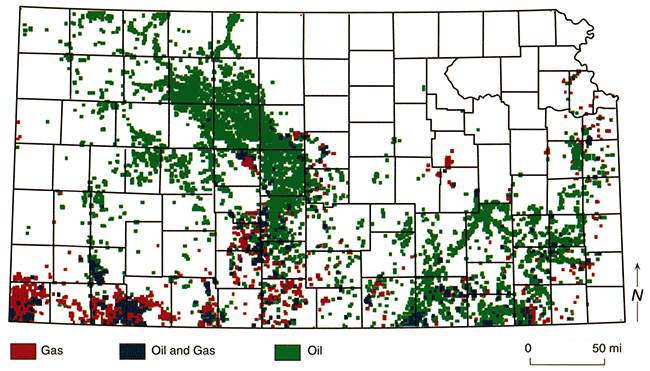
Although categorizing oil and gas by unconformity rather than by producing formation reduces the number of major producing horizons in the state, there is much production that is not associated with major unconformities. For example, Middle and Upper Ordovician oil (fig. 9), principally from Simpson Sandstone and Viola Limestone, is not associated with any major angular unconformity. The northeast-southwest production trend in these Ordovician units parallels the Transcontinental arch, and its oil has a distinctive geochemical signature (Martin et al., 1963; Hatch et al., 1987). On the eastern flank of the Forest City basin, some of this oil has migrated vertically into Pennsylvanian reservoirs, and into Devonian "Hunton" carbonates along its axis (Newell,Watney, Stephens, and Hatch, 1987). Pennsylvanian production (fig. 10) and Permian production also are not consistently associated with anyone major unconformity, although similarity in the spatial distribution of oil and gas production with that of the basal Pennsylvanian unconformity (fig. 4) indicates some of this production also may have leaked upwards through faults and stratigraphic connections.
Figure 9--Distribution of petroleum production from Middle and Upper Ordovician strata in Kansas where these strata are not subcropping beneath either the angular unconformities at the base of the Chattanooga Shale, or the base of the Pennsylvanian System (composited from data in Newell, Watney, Cheng, and Brownrigg, 1987).
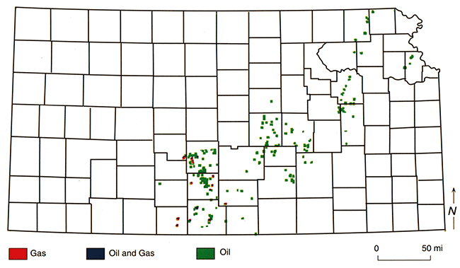
Figure 10--Distribution of petroleum production from Pennsylvanian rocks in Kansas (composited from data in Newell, Watney, Cheng, and Brownrigg, 1987).
If hydrocarbon production is considered by its distribution along unconformities, we then approach its occurrence as a "petroleum system." As defined by Magoon (1991), the "petroleum system" considers the relationships of all necessary conditions for the creation of a petroleum field, including source rock, overburden, reservoir, seal, and trap. Of course, only the locations of known traps are recorded by production maps; nevertheless, better inferences can be made as to migration and potential source beds of the petroleum. It is therefore proposed that most of the oil along the basal Pennsylvanian unconformity will be geochemically identical, regardless of whether it is found in Mississippian "chat" in the Sedgwick basin, or in Arbuckle carbonates on the crest of the Central Kansas uplift. Similarly, oil found at the base of the Chattanooga Shale may also be geochemically distinct regardless of whether the pay zone is in the Silurian-Devonian "Hunton Group" or the Middle Ordovician Viola Formation, just so long as these units are in the similar geologic position of being truncated by the unconformity at the base of the Chattanooga Shale. Although analyses (Hatch et al., 1987; Newell, Watney, Stephens, and Hatch, 1987) indicate that oil in Middle and Upper Ordovician strata (e.g., Simpson Group, Viola Formation, and Maquoketa Formation) is geochemically unique, this distinctive oil may be mixed with other oils where these units are truncated by major unconformities. A geochemical study of oil and gas along the major unconformities in Kansas could elucidate how the production migrated and accumulated, and the maps presented here may afford a more logical approach to such a study.
Adler, F. J., Caplan, W. M., Carlson, M. P., Goebel, E. D., Henslee, H. T., Hicks, I. C., Larson, T. G., McCracken, M. H., Parker, M. C., Rascoe, B., Schramm, M. W., and Wells, J. S., 1971, Future petroleum provinces of the midcontinent; in, Future Petroleum Provinces of the United States--Their Geology and Potential, I. H. Cram, ed.: American Association of Petroleum Geologists, Memoir 15, p. 985-1,120
Bickford, M. E., Harrower, K. L., Nussbaum, R. L., Thomas, J. J., Nelson, B. K., and Hoppe, W. J., 1981, Rb-Sr and U-Pb geochronology and distribution of rock types in the Precambrian basement of Missouri and Kansas: Geological Society of America, Bulletin, v. 92, p. 323-341
Carr, T. R., 1994, Kansas oil and gas production trends: Kansas Geological Society, Bulletin, v. 69,no. 8,p. 12-14,29-30
Carr, T. R., Ross, J. A., and Beene, D. L., 1993, Producing horizons of oil and gas fields: Kansas Geological Survey, Maps M35-1 to M35-12 (12 sheets, 1:250,000 scale)
Gerhard, L. C. (subcommittee chairman), 1992, Fossil energy strategy for Kansas; in, Kansas Energy Policy Committee Report submitted to Governor Joan Finney (February 1993), J. P. Jennings, chmn.: Energy Research Center, University of Kansas, Lawrence
Gerhard, L. C., Watney, W. L., Carr, T. R., Collins, D. R., and Newell, K. D., 1994, Potential for discovery and production from the Kansas crude oil resource base: Kansas Geological Survey, Open-file Report 94-30, 9 p.
Gussow, W. C., 1954, Differential entrapment of oil and gas: American Association of Petroleum Geologists, Bulletin, v. 39, p. 547-574
Hatch, J. R., Jacobson, S. R., Witzke, B. J., Risatti, J. B., Anders, D. E., Watney, W. L., Newell, K. D., and Vuletich, A. K., 1987, Possible late Middle Ordovician organic carbon isotope excursion; evidence from Ordovician oils and hydrocarbon source rocks, midcontinent and east-central United States: American Association of Petroleum Geologists, Bulletin, v. 71, p. 1,342-1,354
Jenden, P. D., Newell, K. D., Kaplan, I. R., and Watney, W. L., 1988, Composition and stable-isotope geochemistry of natural gases from Kansas, midcontinent, U.S.A.: Chemical Geology, v. 71, p. 117-147
Jewett, J. M., 1954, Oil and gas in eastern Kansas: Kansas Geological Survey, Bulletin 104 (reprinted 1979), 397 p.
Jewett, J. M., and Merriam, D. F., 1959, Geologic framework of Kansas--a review for geophysicists; in, Symposium on Geophysics in Kansas, W. W. Hambleton, ed.: Kansas Geological Survey, Bulletin 137, p. 9-52 [available online]
Lam, C.-K., and Yarger, H. L., 1989, State gravity map of Kansas; in, Geophysics in Kansas, D. W. Steeples, ed.: Kansas Geological Survey, Bulletin 226, p. 185-196 [available online]
Lambert, M. W., 1988, Sub-Pennsylvanian subcrop map of Mississippian units in the Salina basin: Kansas Geological Survey, Open-file Report 88-37 (1 :500,000 scale map) [available online]
Lambert, M. W., 1992, Internal stratigraphy of the Chattanooga Shale in Kansas and Oklahoma; in, Source Rocks in the Southern Midcontinent, K. S. Johnson and B. Cardott, eds.: Oklahoma Geological Survey, Circular 93, p. 94-103
Magoon, L. B., 1991, The petroleum system-from source to trap: American Association of Petroleum Geologists, Bulletin, v. 75, p. 627
Martin, R., Winters, J. C., and Williams, J. A., 1963, Distributions of n-paraffins in crude oils and their implications to petroleum: Nature, v. 199, p. 110-113
Merriam, D. F., 1963, The geologic history of Kansas: Kansas Geological Survey, Bulletin 162, 317 p. [available online]
Newell, K. D., 1987a, Pre-Pennsylvanian subcrop map of Salina basin, Kansas: Kansas Geological Survey, Open-file Report 87-3 (1:500,000 scale map) [available online]
Newell, K. D., 1987b, Sub-Chattanooga subcrop map of Salina basin, Kansas: Kansas Geological Survey, Open-file Report 87-4 (1 :500,000 scale map) [available online]
Newell, K. D., Watney, W. L., Cheng, S. W. L., and Brownrigg, R L., 1987, Stratigraphic and spatial distribution of oil and gas production in Kansas: Kansas Geological Survey, Subsurface Geology Series 9, 87 p. [available online]
Newell, K. D., Watney, W. L., Stephens, B. P., and Hatch, J. R., 1987, Hydrocarbon potential in Forest City basin: Oil and Gas Journal, v. 88 (October 19th), p. 58-62
Newell, K. D., Watney, W. L., Steeples, D. W., Knapp, R. W., and Cheng, S. W. L., 1989, Suitability of high-resolution seismic method to identifying petroleum reservoirs in Kansasa geological perspective; in, Geophysics in Kansas, D. W. Steeples, ed.: Kansas Geological Survey, Bulletin 226, p. 9-29 [available online]
Oros, M. O., 1979, Oil and gas in eastern Kansas, a 25-year update; in, Oil and Gas in Eastern Kansas: Kansas Geological Survey, Bulletin 104 (reprinted 1979), p. 3-30
Parham, K. D., 1993, Introduction to Permian plays; in, Atlas of Major Midcontinent Gas Reservoirs, D. G. Bebout, W. A. White, T. F. Hentz, and M. K. Grasmick, eds.: Bureau of Economic Geology, Austin, TX, p. 6-7
Rummerfield, B. F., and Rummerfield, L. J., 1989, Seismic exploration for the Morrow trend; in, Geophysics in Kansas, D. W. Steeples, ed.: Kansas Geological Survey, Bulletin 226, p. 67-80 [available online]
Rutter, A. W., III, 1993, 3D seismic applications and implementation; in, Reservoir Description Workshop--Application of Underused Technologies, W. L. Watney and R. S. Sawin, comps.: University of Kansas, Technology Transfer Series 93-1, p. 353-360
Schlee, J. S., 1984, Interregional unconformities and hydrocarbon accumulation: American Association of Petroleum Geologists, Memoir 35, 184 p.
Steeples, D. W. (ed.), 1989, Geophysics in Kansas: Kansas Geological Survey, Bulletin 226, 312 p. [available online]
World Oil, 1994, U.S. oil and gas reserves hit 15-year lows: World Oil, v. 215, no. 2 (February), p. 84-85
Yarger, H. L., 1983, Regional interpretation of Kansas aeromagnetic data: Kansas Geological Survey, Geophysical Series 1, 35 p. [available online]
Yarger, H. L., 1989, Major magnetic features in Kansas and their possible geologic significance; in, Geophysics in Kansas, D. W. Steeples, ed.: Kansas Geological Survey, Bulletin 226, p. 197-213 [available online]
Zeller, D. E., ed., 1968, The stratigraphic succession in Kansas: Kansas Geological Survey, Bulletin 189, 81 p. [available online]
Previous--Introduction and Overview of the Atlas Papers || Next--Basement Tectonic Configuration in Kansas
Kansas Geological Survey
Comments to webadmin@kgs.ku.edu
Web version placed online Aug. 14, 2015. Original publication date 1995.
URL=http://www.kgs.ku.edu/Publications/Bulletins/237/Newell2/index.html