Previous--Overview of Petroleum Geology || Next--Basement Control of Selected Oil and Gas Fields
Kansas Geological Survey
This article available as an Acrobat PDF file (3.6 Mb).
The structure of the Precambrian basement of Kansas, midcontinent USA, is dominated by conjugate north-northeast- and northwest-trending wrench fault zones. North-northeast-trending faults of the Midcontinent Rift System (MRS) extend from Lake Superior across Kansas and into north-central Oklahoma. The fault zone widens from about 100 km (60 mi) in northeast Kansas to more than 160 km (96 mi) in south-central Kansas in a series of horsetail splays. North-northeast-trending structures of the MRS are displaced by about 80 km (48 mi) of dextral offset by the northwest-trending strike-slip fault zone.
Apparently penecontemporaneous northwest-trending wrench faults of the Bourbon ArchCentral Kansas uplift cross the state from southeast to northwest, offsetting MRS structures. The two conjugate wrench fault zones are complexly interrelated in central Kansas, where internal synthetic shears complicate axial horsts and grabens of the MRS. The Bourbon Arch is offset approximately 100 km (60 mi) by sinistral slip from the Central Kansas uplift along the MRS. The Humboldt fault zone at the eastern margin of the MRS was not offset significantly by northwest-trending faults, suggesting that the present-day expression of the southward-weakening fault zone was created during Pennsylvanian (Upper Carboniferous) rejuvenation of the basement fabric. Stratigraphic relationships record a history of repeated reactivation in Paleozoic time that strongly affected petroleum entrapment, with an especially strong pulse of uplift during Pennsylvanian time.
These rift zones are segments of continental-scale basement lineaments that are fundamental to the structural fabric of the North American basement. The Bourbon Arch-Central Kansas structural lane lies sub-parallel to the Olympic-Wichita lane that extends from southern Oklahoma to the northwest through the Paradox basin of eastern Utah, and the MRS lies sub-parallel to the Colorado Lineament which extends from the Grand Canyon in Arizona to the Lake Superior region. Thus, the basement of the western midcontinent and southern Rocky Mountains consists of large-scale fault zones that delineate suborthogonal basement blocks.
The midcontinent and the state of Kansas, in particular, are generally believed to be geologically structureless like the scenery. Yet upon close examination of geophysical and subsurface data, the basement is found to be complexly faulted. In spite of earlier interpretations to the contrary, the basement of Kansas is here interpreted to be broken by wrench fault zones of regional proportions. These fault zones readily fit in a continental-scale structural fabric, which will be seen to delineate regional crustal blocks that together form the North American craton.
The Midcontinent Rift System (MRS) (sometimes referred to as the Central North American Rift System or Midcontinent Gravity High) has long been recognized from geophysical mapping to trend south-southwestward from Lake Superior into central Kansas in a snake-like curving pattern. Faults of this zone trend north-northeast-southsouthwest across east-central Kansas, splaying outward toward the south (fig. 1). Lying parallel to the MRS immediately to the east is a complexly faulted positive feature known as the Nemaha uplift, bounded on the east by the Humboldt fault zone (Berendsen and Blair, 1986). In spite of its proximity and parallel trend, the Nemaha fault zone has generally been considered as a separate structure from the MRS, extending from southeastern Nebraska across eastern Kansas into north-central Oklahoma (Dolton and Finn, 1989).
Another prominent trend of basement faults crosses the MRSNemaha fault zone at near right angles. Numerous northwest-southeast-oriented faults extend from central Missouri into east-central Kansas, comprising what is often referred to as the Bourbon Arch complex (fig. 1). The Bourbon arch that affected lower to middle Paleozoic depositional patterns includes, and is bounded by, this zone of faults. The Bourbon arch complex appears to abut the Nemaha uplift. Another swarm of northwest-southeast faults in west-central Kansas marks a structurally high platform known as the Central Kansas uplift (CKU) (fig. 1). This faulted block appears to abut fault extensions of the MRS in central Kansas.
Figure 1--Map of the state of Kansas showing generalized fault patterns in the Precambrian basement as derived from subsurface studies. North-northeast-south-southwest faults are believed to be sinistral strike-slip faults and northwest-southeast structures are interpreted to be dextral strike-slip faults.
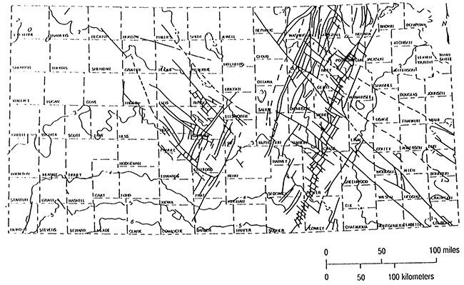
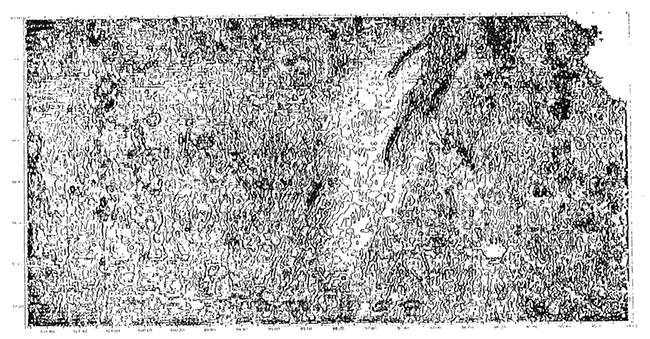
Subsurface mapping of lower Paleozoic rocks and the upper Precambrian surface reveals that the northwest-trending Bourbon arch fault zone complexly offsets faults of the Nemaha-MRS fault zone in east-central Kansas, breaking the basement into myriad suborthogonal fault blocks (fig. 1; Berendsen and Blair, 1986). Similarly, the southeastern extension of the Central Kansas uplift is complexly offset by faults that appear to be southerly extensions of the MRS (fig. 1). Geophysical maps, especially the second vertical derivative of gravity map (fig. 2), confirm these strongly intersecting relationships.
Figure 2--Second vertical derivative magnetic map of Kansas (reduced to the pole) compiled by the Kansas Geological Survey. The MRS is strongly apparent in the north-central part of the state, but other basement structures with north-northeast and northwest orientations are apparent. Compare with the basement structure map of fig. 1.
Berendsen and Blair (1986) interpreted the Nemaha-MRS fault system to exhibit sinistral strike-slip displacement along a regional wrench-fault zone, and this study confirms that interpretation. Many local offsetting relationships found on the Central Kansas uplift strongly suggest that dextral strike-slip movement has occurred along the northwest-trending fault zone as well.
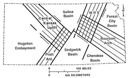
In an effort to make order out of this chaos, the author has produced an interpretive sketch map (fig. 3) which demonstrates the present interpretation that the two fault trends intersect in central Kansas, each set displacing the other in their respective senses. The northwest-oriented Bourbon Arch-Central Kansas trend is offset sinistrally by Nemaha-MRS faults, and the Nemaha-MRS fault zone is offset in a dextral sense by the Bourbon Arch--Central Kansas faults. These zones of intersecting faults are further complicated by synthetic shears along the Nemaha uplift. That these faults displace one another suggests that movement of both sets was essentially penecontemporaneous. Thus, the intersection of the two major fault zones is interpreted as forming a conjugate set in central Kansas.
Figure 3--Grossly generalized depiction showing the interpretation of the basement structural and magnetic maps of figs. 1 and 2. Structural fabrics are indicated by ruled patterns and interpreted sense of displacement shown with arrows. Where the structures cross in central Kansas, complex intersecting pattems result. The fault zones form basement uplifts that divide the region into five Paleozoic depositional basins.
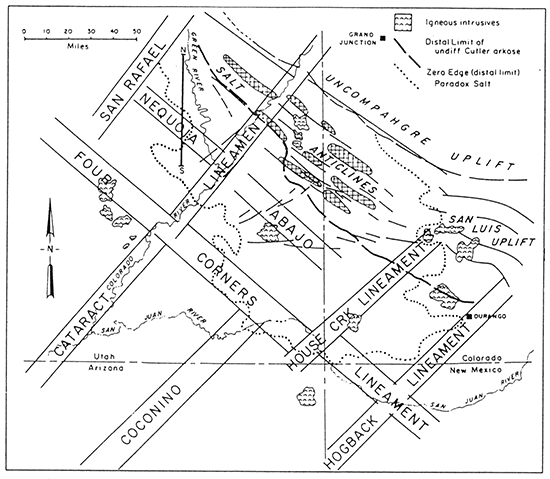
A similar intersection of northwest-southeast and northeast-southwest wrench fault zones was documented as occurring in the Paradox evaporite basin of southeastern Utah by Baars (1966) and Warner (1978). Warner cited evidence that the northeast-trending Colorado Lineament displays sinistral strike-slip offset, originating at about 1.7 Ga (middle Precambrian time). Baars and Ellingson (1984) further documented evidence that the northwest-trending Olympic-Wichita Lineament is a dextral wrench-fault zone of 1.6 to 1.7 Ga origin. As in Kansas, the intersecting wrench-fault zones appear to displace each other, forming a conjugate set. Stevenson and Baars (1986) interpreted the fault-bounded Paradox basin to be a large pull-apart basin of Pennsylvanian age, formed by reactivation along the northwesterly Olympic-Wichita Lineament, with extension facilitated by the northeasterly Colorado Lineament (fig. 4). The fault-bounded Uncompahgre uplift to the northeast supplied vast quantities of clastic sediments to the adjoining basin.
Figure 4--Tectonic map of the Paradox basin, southeastern Utah and southwestern Colorado, from Stevenson and Baars (1986). Northwesterly fault zones, indicated as basement "lineaments," are parts of the Olympic-Wichita Lineament, and northeasterly trends lie along the Colorado Lineament (see text). The Paradox evaporite basin of Pennsylvanian (Lower Carboniferous) age was interpreted to be a pull-apart basin. Compare this regmatic basement fabric with the regional structural pattern of fig. 6.
Although movement originated in middle Precambrian time, Baars (1966) documented strong evidence that movement along the Olympic-Wichita Lineament was rejuvenated in Late Cambrian, Late Devonian, Early Mississippian, and Middle Pennsylvanian time. Reactivation in Late Devonian time created shallow marine fault blocks upon which offshore sand bars formed and became petroleum reservoirs. Mississippian reactivation formed structurally controlled shoaling conditions that fostered development of Waulsortian banks, which upon dolomitization became excellent petroleum reservoirs (Baars, 1966). Further reactivation in Middle Pennsylvanian time again caused subtle shoals along the southern shelf of the Paradox basin that localized the development of algal bioherms that have produced prolific amounts of petroleum (Baars and Stevenson, 1982).
The Olympic-Wichita Lineament, the key element in the origin of the Paradox basin, extends to the northwest at least across Utah, and has been interpreted (Baars, 1976) to be an extension of the Olympic-Wallowa Lineament of Wise (1963). It can be traced to the southeast into the fault complex of the southern Oklahoma aulacogen and beyond (Baars, 1976). The composite magnetic anomaly map of the United States (U.S. Geological Survey, 1982, from Hinze and Braile, 1988, plate 1B) clearly confirms these relationships. Thus, the Olympic-Wichita Lineament is a continental-scale structural feature interpreted to play a major role in the basement architecture of the North American craton (figs. 5 and 6).
Figure 5--Map of the western United States showing locations of some of the most significant fault zones and lineaments in the Precambrian basement. Faults in the northern midcontinent, north of Kansas, are generalized from Sims (1990). Where sense of displacement has been determined, northwesterly structures are dextral and northeasterly structures are sinistral. In most cases, complex fault zones are shown as single lines.
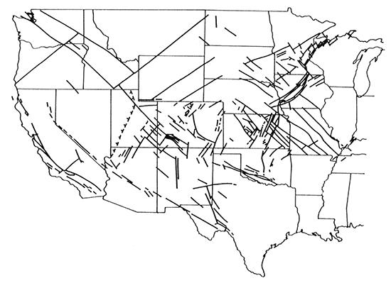
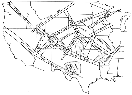
Figure 6--Summary map showing generalized basement structural zones of fig. 5, and the names applied to these continental-scale trends. Abreviations are: MRS = Midcontinent Rift System; CKU = Central Kansas uplift; Cam = Cambridge arch; Chad = Chadron arch. Note the obvious relationships of late Paleozoic depositional basins (Oquirrh, Paradox, Anadarko, and Arkoma) to the basement structural fabric. These are all fault-bounded basins of Pennsylvanian-Permian age formed by rejuvenation of basement structures during the Ancestral Rocky Mountains orogeny.
The Pennsylvanian Paradox pull-apart basin lies along the Olympic-Wichita Lineament and is complimentary to a major fault-bounded uplift. In like fashion, the Pennsylvanian Anadarko and Arkoma basins of Oklahoma are intimately related to the same structural lineament, but lie in mirror-image to the Paradox basin. The uplifted sources of voluminous clastic sediments in southern Oklahoma occur to the south, and the deep structural basins are to the north of the fault zone (fig. 6). The deep basins of central Oklahoma are bounded generally to the north by a structurally controlled shallow shelf that lies along the Bourbon Arch-Central Kansas fault complex that in Kansas lies sub-parallel to the Olympic-Wichita Lineament (fig. 6). It is easy to interpret a close relationship between these Oklahoma basins and adjacent basement structures. (Perhaps these are also pull-apart basins?) As in the Paradox basin, Paleozoic rocks of the Kansas shelf of the Oklahoma basins show a long history of Paleozoic tectonic rejuvenations. Additionally, petroleum production from these strata is prolific.
Precambrian basement structures of the northern midcontinent are shown on fig. 5. To the north and east of Kansas, the structure has been generalized from Sims (1990). As previously discussed, the Midcontinent Rift System and the Central Plains Orogen are the principal structural features linking Kansas to the craton. It is noteworthy that the structural fabric of the northern midcontinent is, like the margins of the craton to the south and west, a network of northwest-southeast and northeast-southwest fault zones, many of which have been interpreted to be strike-slip structures (Sims, 1990). Thus, it appears that the basement structural fabric of the North American craton comprises several suborthogonal, fault-bounded blocks.
Figure 6 is a highly generalized map showing the relationships of Kansas basement structures to others of the midcontinent. Late Paleozoic fault-related basins are superimposed on the map to indicate their probable associations with basement structure. The interpretation shown on fig. 6 presents the MRS as a series of left-stepping en echelon fault zones as they appear to have occurred prior to extensional rifting. If this interpretation is correct, the MRS may consist of three originally distinctive compressional structures, later apparently joined by clockwise rotation of their associated crustal blocks, followed by late Precambrian relaxation of stress now exemplified by extension along the rift zone.
Such an interpretation of the MRS would explain the apparent age and structural discrepancies along the rift. Sims (1990, p. 5) depicts the northern rift as "…a medial horst of basalt-rhyolite flows and local overlying sedimentary basins that is flartked by red-beds, which compose clastic wedges along the margins of the rift." He (Sims, 1990) assigned an age of 1,000-1,200 Ma for basalts within the rift, or "about 1,100 Ma."
In contrast, the MRS in Kansas consists of numerous fault blocks (figs. 1 and 2), some of which contain predominantly basalts and others arkosic red beds; still others contain composite lithologies. Texaco recently drilled the Poersch #1 well within the MRS in southeastern Washington County, Kansas (SW SW sec. 31, T. 5 S., R. 5 E.), drilling and coring 8,454 ft (2,536 m) of Precambrian rocks. The upper 4,583 ft (1,3751 m) of Precambrian rock consisted of predominantly basalt and gabbro, with a few thin beds of arkose. The lower 3,871 ft (1,161 m) was predominently arkose with minor amounts of basalt and gabbro; the well bottomed in arkose (Berendsen et al., 1988). K-Ar dates by three different laboratories ranged from 587 to 800 Ma for a gabbro near the top of the Precambrian to 837-1,021 Ma for the deepest basalt encountered (Berendsen et al., 1988). Thus, rocks drilled in the deep test were considerably younger than the 1,100 Ma date for the northern MRS. Concern within the Kansas Geological Survey regarding the viability of these dates stems more from the younger age of the rocks in Kansas than of the quality of the dating process.
A possible interpretation of the sequence of tectonic events that molded the basement of the midcontinent U.S.A. may be summarized as follows:
The highly complex fault patterns of Kansas fit well with the continental-scale regmatic structure of the North American craton. When viewed at a continental scale, fault trends in Kansas are seen as segments of large-scale structural lanes that comprise the regional basement fabric. Although these structures originated in late Precambrian time, they were reactivated repeatedly throughout the Phanerozoic, affecting depositional and erosional patterns that localized petroleum reservoirs. Fault-controlled basement uplifts in Kansas comprise the complex northern shelves of the Oklahoma Pennsylvanian-age basins and are thus instrumental in controlling petroleum emplacement.
Baars, D. L., 1966, Pre-Pennsylvanian paleotectonics--Key to basin evolution and petroleum occurrences in Paradox basin, Utah and Colorado: American Association of Petroleum Geologists, Bulletin 50, p. 2,082-2,111
Baars, D. L., 1976, The Colorado Plateau aulacogen, key to continental-scale basement rifting: 2nd International Conference on Basement Tectonics Proceedings, p. 157-164
Baars, D. L., and Ellingson, J. A., 1984, Geology of the westem San Juan Mountains; in, Field Trip Guidebook, D. C. Brew, ed.: 37th Annual Meeting, Rocky Mountain Section, Geological Society of America, p. 1-45
Baars, D. L., and Stevenson, G. M., 1982, Subtle stratigraphic traps in Paleozoic rocks of Paradox basin; in, Deliberate Search for the Subtle Trap, M. T. Halbouty: American Association of Petroleum Geologists, Memoir 32, p. 131-158
Berendsen, P., and Blair, K. P., 1986, Subsurface structural maps over the Central North American Rift System (CNARS), central Kansas, with discussion: Kansas Geological Survey, Subsurface Geology Series 8, 16 p., 7 maps [available online]
Berendsen, P., Borcherding, R. M., Doveton, J., Gerhard, L., Newell, K. D., Steeples, D., and Watney, W. L., 1988, Texaco Poersch #1, Washington County, Kansas--Preliminary geologic report of the pre-Phanerozoic rocks: Kansas Geological Survey, Open-file Report 88-22, 116 p.
Dolton, G. L., and Finn, T. M., 1989, Petroleum geology of the Nemaha uplift, central midcontinent: U.S. Geological Survey, Open-file Report 88-450-D, 39 p. [available online]
Kluth, C. G., and Coney, P. J., 1981, Plate tectonics of the Rocky Mountains: Geology, v. 9, p. 10-15
Hinze, W. J., and Braile, L. W., 1988, Geophysical aspects of the craton, U.S; in, Sedimentary Cover-North American Craton, U.S., L. L. Sloss, ed.: Boulder, Colorado, Geological Society of America, The Geology of North America, v. D-2, p. 5-24, plates
Sims, P. K., 1990, Precambrian basement map of the northern midcontinent, U.S.A.: U.S. Geological Survey, Map I-1853-A [available online]
Stevenson, G. M., and Baars, D. L., 1986, The Paradox-A pull-apart basin of Pennsylvanian age; in, Paleotectonics and Sedimentation in the Rocky Mountain Region, United States, J. A. Peterson, ed.: American Association of Petroleum Geologists, Memoir 41, p. 513-539
Warner, L. A., 1978, The Colorado Lineament--A Middle Precambrian wrench fault system: Geological Society of America, Bulletin 89, p. 161-171
Wise, D. U., 1963, An outrageous hypothesis for the tectonic pattern of the North American Cordillera: Geological Society of America, Bulletin 74, p. 357-362
Previous--Overview of Petroleum Geology || Next--Basement Control of Selected Oil and Gas Fields
Kansas Geological Survey
Comments to webadmin@kgs.ku.edu
Web version placed online Aug. 14, 2015. Original publication date 1995.
URL=http://www.kgs.ku.edu/Publications/Bulletins/237/Baars1/index.html