![]()
Prev Page--Regional Studies || Next Page--More County Studies
County Studies
Atchison County
Geology
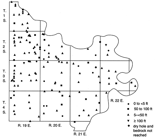
Westward-dipping Pennsylvanian bedrock underlies Atchison County (fig. 5), and some exposures occur along streams and near the Missouri River (Frye, 1941; Ward, 1973). Along the eastern edge of the county, the upper Douglas Group (especially sandstone and shale) crops out. Limestones and shales of the Shawnee Group occur in the eastern and central parts of the county, and shales and limestones of the lower Wabaunsee Group are found in or under the western two-thirds.
The geologic map of Atchison County (Ward, 1973) suggests glacial buried valleys in areas where bedrock exposures are absent along modern streams and/or where the alluvial deposits widen (e.g., the Delaware River in T. 6 S., R. 17 E.; Stranger Creek in T. 6 S., R. 19 E.; Clear Creek in sec. 6, T. 5 S., R. 18 E.; and Grasshopper Creek in secs. 29 and 30, T. 5 S., R. 18 E., and sec. 3, T. 6 S., R. 17 E.). A map of the bedrock topography (plate 1), prepared using data from 353 well logs (Denne et al., 1990a) and the county geologic map with surface topographic contours (Ward, 1973), indicates a major buried valley trending from the west to the east for 25 mi (40 km) across the middle of the county. The width of the main channel ranges from 0.5 to 2.5 mi (0.8-4.0 km), and many smaller tributaries enter from the north and south. Modern stream drainage in Atchison County is predominantly to the south and southeast. Bedrock exposed at or near the land surface controls the drainage (and contours) evident in the northwestern, southwestern, and eastern parts of the county. Near these areas differentiation of the modern and buried drainage systems is complex (e.g., near the border between T. 5 S., R. 17 E., and T. 5 S., R. 18 E.).
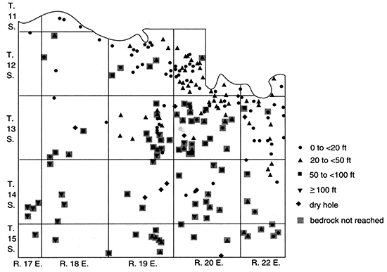
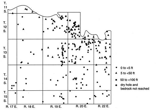
The depth to bedrock is greatest over the buried valleys (fig. 10), and exceeds 250 ft (76 m) in some places. The unconsolidated deposits in Atchison County include a basal limestone and chert gravel, a fine-grained silty sand of the Atchison Formation, at least two different tills (with a locally occurring layer of outwash between them), the Nortonville Clay, loess, terrace deposits, and alluvium (Ward, 1973). The total thickness of sand and gravel (fig. 11) ranges up to 155 ft (47 m). In the buried valleys the Atchison Formation generally makes up the bulk of these sediments (up to 105 ft [32 m]); basal gravels account for as much as 36 ft (11 m) but usually less than 10 ft (3 m); and lenses of sand and/or gravel within or between the tills make up the balance (Denne et al., 1990a). Alluvium in the Missouri River valley is commonly 100 ft (30 m) thick, with sand and gravel predominating. In smaller stream valleys the clayey alluvium and terrace deposits are 15-50 ft (5-15 m) thick and generally contain less than 5 ft (2 m) of basal sand and gravel fill, but locally have a thickness up to 25 ft (7.6 m). The log for an oil well in the Delaware River valley (NW SW SW sec. 21, T. 7 S., R. 17 E.) indicates that bedrock occurs at 130 ft (40 m), providing a bedrock elevation of 795 ft (242 m) at this site; thus either a narrow, deep buried channel underlies the more recent alluvial deposits, or the well log or location is in error. The Nortonville Clay and loess deposits, each of which is less than 50 ft (15 m) thick, do not contain sand and gravel.
Figure 10--Depth to bedrock, Atchinson County.
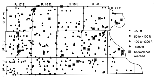
Figure 11--Total Pleistocene sand and gravel thickness, Atchison County.
Frye (1941; fig. 5) prepared a map of areas in Atchison County where wells obtain water from Pleistocene sands. It shows a lobate pattern connecting parts of the main buried valley and its tributaries as presently mapped (plate 1) and as mapped by Ward (1973). Frye (1941) observed that the lower of two tills (which he considered Nebraskan) was present from southern Doniphan County only to Cummings in southern Atchison County and that, although the unit may have covered the entire county, only the eastern two-thirds now has such deposits. The presence of a continuous buried channel was recognized by 1950, when Frye and Walters indicated a "filled early Pleistocene valley" extending from Marshall County into T. 6 S., R. 17 E., of Atchison County. In 1952, Frye and Leonard mapped this drainage, which extends eastward across the entire county and is partially coincident with the limit of Nebraskan ice (cf., early Independence glacial limit; fig 7). In the future detailed stratigraphic and geomorphic studies should be done to evaluate potential relations between the buried valleys and to find the best sand and gravel deposits and better define the position of the ice margin. Such investigations should provide excellent strategies for obtaining good groundwater supplies.
Ground Water
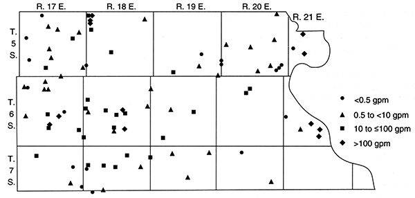
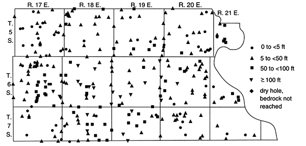
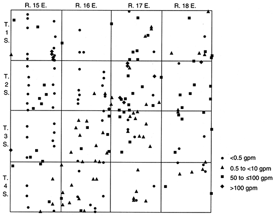
Ground-water yields to wells with various diameters and other construction characteristics in Atchison County show a large range (fig. 12). The bedrock units commonly yield less than 1 gpm (0.00006 m3/s), although sandstones, fractured limestones, and weathered zones may provide somewhat greater quantities locally (Ward, 1973). In contrast, the glacial aquifers yield 5-200 gpm (0.0003-0.01 m3/s). The basal gravel, other glaciofluvial deposits, and the Atchison Formation yield the largest amounts of water, but wells completed in the last unit must be constructed and developed carefully so that they do not pump the fine-grained silty sand. Sand and gravel lenses within the tills are frequently small and discontinuous; thus recharge may be inadequate for sustained pumpage. Alluvial aquifers are also important sources of ground water in Atchison County. Well yields of up to 3,000 gpm (0.2 m3/s) are available from the Missouri River valley, and the smaller tributary valleys commonly provide up to 5 gpm (0.0003 m3/s) and locally may yield 35 gpm (0.0022 m3/s).
Figure 12--Estimated well yields, Atchison County.
Ground-water recharge to the buried-valley aquifers is predominantly from precipitation, although leakage from bedrock units contributes to the amount. Discharge is to streams, seeps, springs, and wells, some of which flow (Ward, 1973; Frye, 1941). Four areas with artesian flow were mapped by Ward (1973, sheet 2); the main one is on the eastern side of the Delaware River valley in T. 6 S., R. 17 E., where the sand and gravel aquifer is confined between relatively impermeable till and alluvium above and bedrock below.
Ward (1973) mapped potentiometric contours only in the major stream valleys because he recognized the discontinuous nature of the potentiometric surface in other areas. A map of water elevations calculated from Denne et al. (1990a) also indicates that discontinuities and other problems (e.g., composite water levels from wells penetrating multiple aquifers) limit the usefulness of these data to construct contours and to determine ground-water-flow directions.
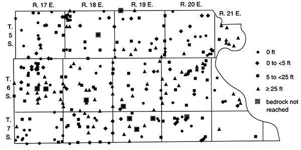
The depth to water and saturated thickness of unconsolidated deposits are shown in figs. 13 and 14, respectively, but the same limitations apply to these values. In general, the depth to water is less than 30 ft (9 m) in alluvial deposits and considerably less than the deepest reported value of 180 ft (55 m) in glacial aquifers. Water levels greater than 50 ft (15 m) deep commonly are associated with parts of the deep buried valleys (e.g., in T. 6 S., R. 18 E.) and bedrock wells. The saturated thickness of alluvial deposits approaches 100 ft (30 m) in the Missouri River valley and is 0-40 ft (0-12 m) in the smaller stream valleys. Saturated-thickness values in the rest of the county range up to 225 ft (68.6 m), with the greatest saturated thicknesses occurring in the buried valleys. However, if the bulk of the saturated material is of low permeability (e.g., glacial till or Nortonville Clay), even large thicknesses may not yield a significant quantity of water. On the other hand, where sand and gravel layers are present, saturated thicknesses as small as 5-15 ft (2-5 m) have been reported to yield at least 3 gpm (0.0002 m3/s).
Figure 13--Depth to water in wells and test wells, Atchison County.
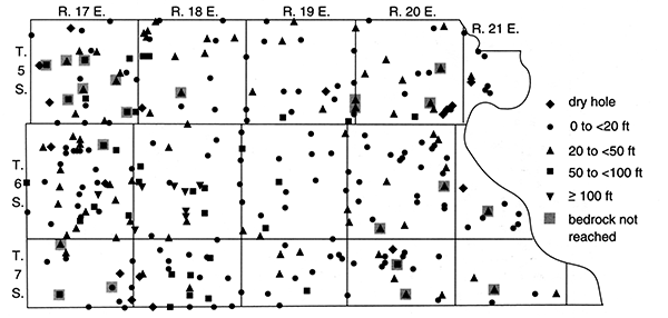
Figure 14--Saturated thickness of Pleistocene deposits, Atchison County.
Geologic Sections
Geologic cross section A-A' (fig. 15) represents part of the main buried valley that starts in southwestern Atchison County and continues into northwestern Jefferson County (fig. 2). A bedrock surface high can be seen in SW NW NW sec. 10, T. 6 S., R. 17 E., corresponding to the bedrock island shown on the map view. This bedrock high is reported from a measured section that indicates boulders and chert gravel near the shale bedrock contact. The Layne-Western Co. drilled five test holes for the city of Muscotah in 1956, all of which are located in the northern part of the cross section. These test holes all fall north of the bedrock high and probably indicate a tributary (plate O. A public supply well constructed for Muscotah in this area has a yield of 10-15 gpm (0.00063-0.00094 m3/s). Farther south in the main buried valley, well yields increase: 50 gpm (0.003 m3/s) in SW SW NW sec. 22, T. 6 S., R. 17 E.; 100 gpm (0.006 m3/s) in NE NW SW sec. 27, T. 6 S., R. 17 E.; and 60 gpm (0.004 m3/s) in SW NW SW sec. 27, T. 6 S., R. 17 E. In the main part of the buried valley, these wells penetrate as much as 50 ft (15 m) of fine-grained sand and 10 ft (3 m) of gravel. The three southernmost test wells in the cross section are from U.S. Geological Survey data and define the bedrock surface but do not give detailed information concerning the glacial formations.
Figure 15--Geologic cross sections and bedrock surface in western Atchison County.
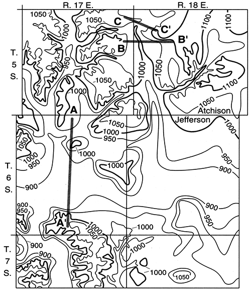
Geologic cross section B-B' (fig. 15) cuts through an extensive tributary to the main buried Valley. Two domestic wells and two test holes supply the data. The western well along the valley wall has a yield of 3 gpm (0.0002 m3/s), and the well located in the valley has a yield of 20 gpm (0.001 m3/s). Gravel layers are located just above the bedrock contacts in the tributary valley and in the upper clay layer on the eastern bedrock high. Surface elevations are slightly higher in the valley regions but do not vary much over the geologic cross section region.
Geologic cross section C-C' (fig. 15) cuts through a tributary valley containing as much as 30 ft (9 m) of fine-grained sand, and well yields are as high as 170 gpm (0.011 m3/s). Data obtained for the geologic section are all from test drilling done by the Layne-Western Co. in 1978 for the city of Horton (Brown County). The city of Everest has also done test drilling in this area. Two Horton public supply wells, located close to Atchison County Lake in sec. 6, T. 5 S., R. 18 E., yield 110 gpm (0.0069 m3/s) and 170 gpm (0.011 m3/s). These wells are close to Atchison County Lake. A domestic well slightly north of the western part of the geologic section has a higher bedrock elevation than any of the wells shown, but it still reports 16 ft (4.9 m) of fine-grained sand and a yield of 15 gpm (0.00095 m3/s).
Brown County
Geology
The cover of glacial deposits in Brown County is generally thinner than in the neighboring counties (fig. 9). Nevertheless, outcrops of Permian and Pennsylvanian bedrock occur primarily along modern stream valleys (fig. 5). Bedrock units in Brown County have been described by Bayne and Schoewe (1967). The Wabaunsee Group of Late Pennsylvanian age is exposed in the eastern half of the county and underlies all of it. This group is 400 ft (120 m) thick and consists primarily of limestones and shales with some sandstone and coal. Permian rocks of the Admire and Council Grove Groups are exposed in the western half of Brown County. The total thickness of these limestones (some of which are cherty) and shales ranges up to 350 ft (110 m).
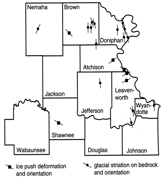
In addition to geologic (Bayne and Schoewe, 1967) and generalized surface topographic maps (U.S. Geological Survey, 1986) modified locally from corresponding topographic bedrock maps, we used records from 509 drill holes (Denne et al., 1990a) to construct the bedrock topographic map shown in plate 1. Where bedrock is exposed or near the land surface (e.g., in western Brown County), the contours reflect the modern surface topography. In other areas buried valleys dominate, although some of these appear to coincide with or connect to modern streams. The lobate shape of many of the modern streams (e.g., Pony, Terrapin, Mulberry, and Spring creeks with Walnut Creek in the northwest quarter of Brown County; Roy Creek in the northeast; Gregg, Plum, and Delaware creeks in the southwest; and the Wolf River and its fork tributaries in the southeast) and the distribution of (upland) gravel and/or sand deposits near and especially south of these drainages suggest that the ice margin was near these locations. Glacial striations and ice-push deformation of bedrock units found in SE NE sec. 28, T. 3 S., R. 15 E., are oriented from 1240 to 1500 (Dellwig and Baldwin, 1965) and indicate ice movement from the northwest (Dakota lobe"), consistent with the direction of lobate streams in the southwest part of the county. Farther east in Brown County, beyond the bedrock high that could have funneled ice lobes, glacial striations (plate 1) indicate ice flow generally to the south or southeast (Schoewe, 1931, 1932, 1941). Although classical moraines are not apparent, the modern streams could have developed at the ice margin or they could have formed later in response to differential rebound of the land surface.
The main buried valley in Brown County extends eastward, just south of the border between T. 1 S. and T. 2 S. (plate 1). The buried channel intersects Walnut Creek at the boundary between R. 16 E. and R. 17 E. and could have drained ice blocking the Walnut Creek valley. A similar connection may have existed between the Spring and Walnut creeks and the Wolf River along the southern edge of T. 2 S., R. 16 E. North-south tributaries through the middle of R. 17 E. and R. 18 E. also may have connected the main buried valley to the Wolf River on the south and drained into the main channel from the north. Additional test drilling should be done to define the possible northern tributaries. For example, a broad area of alluvial deposits along the northwestern edge of T. 1 S., R. 18 E., in Brown County and an associated wide bedrock low extending 2 mi (3 km) toward the Missouri River in Richardson County, Nebraska (Emery, 1964), should be investigated for a southern connection. In addition, several logs in the northern part of T. 1 S., R. 17 E. (e.g., SW SW sec. 3, SW SW sec. 4, and SE SW SE sec. 4), indicate buried drainageways with considerable thicknesses of sand, but their orientations are poorly defined.
Other buried-valley deposits in Brown County occur in the southern part of the county. The northern edge of the major northeastern Kansas buried valley crosses the southwest corner of the county, and a tributary of unknown length extends at least into SESESW sec. 35, T. 4 S., R. 15 E. Another channel, heading toward the area south of the Wolf River, leaves Brown County along the eastern side of the border between R. 17 E. and R. 18 E. Several of the modern streams in T. 4 S. also seem to be near to or to coincide with small buried channels. For example, the great length of the South Fork Wolf River, the eastward curve at its southern end, the bedrock topography, and the sand and gravel deposits in SE SE SE sec. 24, T. 4 S., R. 18 E., suggest that all or part of the river may have once flowed southward into the southeastern part of T. 4 S., R. 18 E.
In Brown County the greatest thicknesses of glacial deposits occur in the buried valley that extends eastward from near the border between T. 1 S. and T. 2 S. (fig. 16). The maximum known depth to bedrock there is 177 ft (53.9 m) (NE NE NW sec. 11, T. 2 S., R. 18 E.). Other significant thicknesses of glacial deposits occur in the buried valleys in the southwestern corner of the county, in T. 1 S., R. 17 E., and in relatively isolated locations along the northern border of the county (e.g., NE SW SW sec. 3, T. 1 S., R. 15 E. and SW NW sec. 4, T. 1 S., R. 16 E.). An oil log for NE NW sec. 7, T. 2 S., R. 16 E., indicates that the depth to bedrock there is 150 ft (46 m), which suggests the presence of a buried tributary to Walnut Creek between and roughly parallel to Terrapin and Mulberry creeks.
Figure 16--Depth to bedrock, Brown County.
As described by Bayne and Schoewe (1967), the unconsolidated deposits in Brown County include chert gravels, glaciolacustrine silt and fine-grained sand, till, outwash, loess, and alluvium. Pre-Kansan chert gravel deposits, ranging up to 20 ft (6 m) thick but generally less than 10 ft (3 m) thick, are exposed in the uplands near Pony Creek in northwestern Brown County and occur locally at the base of the deep buried valley in northeastern Brown County. Bayne and Schoewe (1967) suggested that the Nebraskan glacier may have entered the county, although they did not identify any deposits associated with it. Up to 50 ft (15 m) of silt and fine-grained sand of the Atchison Formation occur near the base of the northeastern Brown County buried Valley. Bayne and Schoewe (1967) believed that these deposits originated in quiet water, such as in a lake formed by ice blockage of drainageways. Glacial-till deposits are heterogeneous mixtures dominated by clay, but they also contain silt, sand, and gravel. Sand and gravel lenses and layers of outwash occur locally within the till. Wisconsinan loess [generally less than 85 ft (26 m) thick] mantles the uplands, especially in the northeastern part of the county, as are the pre-Wisconsinan loess and associated Sangamon Soil (Schoetze, 1986). Alluvial deposits are generally poorly sorted and consist of clay, silt, sand, and gravel. They range up to 55 ft (17 m) thick in the major river Valleys.
The total thickness of all sand and gravel layers in Brown County is greatest in and near the buried valleys (fig. 17). The maximum value is 90 ft (27 m) (in NE NE NW sec. 11, T. 2 S., R. 18 E.) in the main channel just south of T. 1 S. Sand thicknesses up to 88 ft (27 m) also occur in the drainage system in the northern part of T. 1 S., R. 17 E. Gravel was reported at 30-110 ft (9-34 m) in an oil log for SWNW sec. 4, T. 1 S., R. 16 E., at the western edge of the modern Pony Creek valley. Many of the buried valleys contain a basal sand and/or gravel deposit that is less than about 30 ft (9 m) thick and underlies other sand or sand and gravel layers. Some of the modern alluvial valleys contain several feet [generally less than 10 ft (3 m) but locally up to 20 ft (6 m) along the major rivers] of sand and gravel near the underlying bedrock surface. These coarse-grained deposits, where they are saturated, generally yield 50-100 gpm (0.003-0.006 m3/s) of water to wells.
Figure 17--Total Pleistocene sand and gravel thickness, Brown County.
Ground Water
Although no correction factor has been applied to control for wells of different diameters or other characteristics, yields vary considerably in Brown County (fig. 18). Many drill holes yield no water, whereas others have been reported to produce 300 gpm (0.2 m3/s). The largest yield is found in sand and gravel deposits in the main buried valley near its junction with Walnut Creek (sec. 5, T. 2 S., R. 17 E.). Bedrock formations in the Council Grove Group (Permian), especially the Grenola Limestone, Roca Shale, and Foraker Limestone in northwestern Brown County (Bayne and Schoewe, 1967), also yield large quantities of water. The values reported for bedrock wells are as high as 235 gpm (0.0148 m3/s) in NE NW NE sec. 35, T. 1 S., R. 15 E. However, the water becomes more mineralized with depth, and sulfate problems in water from the Foraker Limestone are common.
Figure 18--Estimated well yields, Brown County.
Although the yields from some bedrock units are high, other formations yield no water. Even the same Council Grove Group rock aquifers that yield a large quantity of water in northwestern Brown County are less permeable south of T. 2 S. and generally yield only a few gallons per minute (Bayne and Schoewe, 1967). In eastern Brown County, the Pennsylvanian sandstones provide a small quantity of water to wells, and springs are associated with limestones of the Wabaunsee Group (Bayne and Schoewe, 1967).
Glacial and alluvial aquifers provide additional ground-water supplies where these deposits are saturated. Alluvial deposits in Brown County yield up to 40 gpm (0.003 m3/s) along the major rivers, but most produce only 1-20 gpm (0.00006-0.001 m3/s). Glacial sand and gravel associated with the buried valleys commonly yield 10-150 gpm (0.0006-0.0095 m3/s), although yields as high as 300 gpm (0.2 m3/s) have been obtained. Even where no channel deposits are evident, yields of several gallons per minute can be obtained from some glacial deposits. If fine-grained sands of the Atchison Formation are used for water supplies, wells must be carefully constructed and developed to prevent pumpage of sand.
Although many drill holes encounter no water at all, the greatest depth to water reported to date in Brown County is 130 ft (40 m) in NE NE NE sec. 15, T. 4 S., R. 16 E. (fig. 19). Only three other wells, also in bedrock aquifers in T. 4 S., had water depths greater than or equal to 100 ft (30 m). Most water levels in bedrock wells range from 20 ft to 80 ft (6-24 m). Wells penetrating alluvial aquifers commonly have water at depths less than 20 ft (6 m). Water levels in wells constructed in glacial deposits are generally less than 50 ft (15 m), although the range is 5-90 ft (2-27 m).
Figure 19--Depth to water in wells and test wells, Brown County.
Water-elevation values calculated from data given by Denne et al. (1990a) were not contoured because they were not separated into confined and unconfined aquifers and because they represent only composite values where wells penetrate multiple aquifers. Also, as found by Bayne and Schoewe (1967), the water table is discontinuous. Water-table contours for part of the county indicated that the shape of the water table is similar to the shape of the surface topography and that ground water moves toward and into almost every stream.
Figure 20--Saturated thickness of Pleistocene deposits, Brown County.
The saturated thickness of unconsolidated deposits in Brown County is greatest over the buried valleys in the northeastern and southwestern parts of the county (fig. 20). The values range up to 161 ft (49.1 m) (NE NE NW sec. 11, T. 2 S., R. 18 E.). Most glacial deposits, however, have saturated thicknesses of less than 50 ft (15 m). In the major river valleys the saturated thickness of alluvial deposits may be nearly 50 ft (15 m), but values less than 25 ft (8 m) are more common near most streams.
In Brown County ground-water discharge is to wells, springs, and streams or through evapotranspiration. Recharge is predominantly from precipitation. Bayne and Schoewe (1967) constructed four hydrographs for wells in the county. Three wells in glacial deposits showed similar trends in water-level fluctuations in response to climate. One well in bedrock also showed a similar but more subdued trend in water-level fluctuations.
Doniphan County
Geology
The geology of Doniphan County was mapped by Bayne (1973). Most of the county is covered with alluvial, eolian, and glacial deposits (fig. 9). Bedrock exposures occur along some of the major streams, especially in the south.
The bedrock units at or near the land surface in Doniphan County are Upper Pennsylvanian (fig. 5). Shales and limestone of the Lawrence Formation of the Douglas Group occur in the east. Overlying the Douglas Group is the Shawnee Group, which includes 300 ft (90 m) of shales, limestones, and some sandstones. Up to 100 ft (30 m) of shale with some limestone, coal, and sandstone from the Wabaunsee Group occurs in the western part of the county. The eastern limits of sandstone aquifers in the White Cloud and Stull Shale Members of the Shawnee and Wabaunsee Groups, respectively, are shown in Bayne's (1973) report.
By utilizing data from 189 drill holes (Denne et al., 1990a) and Bayne's (1973) map of geology with surface topography, we have constructed a bedrock topographic map for Doniphan County (plate 1). Where bedrock occurs near the land surface, the contours reflect the surface topography and therefore appear more detailed than in other areas. Several buried valleys are evident on the bedrock topographic map; modern streams suggest other areas where drainage may have been modified during the Quaternary.
Wolf River is a rather small stream for its broad alluvial valley, i.e., an underfed stream. This alone suggests that more water flowed in the channel at an earlier time, but deposits of coarse-grained material (sometimes described by drillers as plate-size; see, for example, the logs for wells in NE NE SE sec. 29, T. 2 S., R. 20 E., and NE NE NE sec. 3, T. 3 S., R. 20 E.) near the river and its tributaries also support the idea of more water flowing with greater tractive force than at present. The lobate shape of the Wolf River system in Brown County has already been discussed; there is a bedrock high on the south and east side of the Wolf River in Doniphan County, and thus the drainage here also may have developed marginal to the ice.
The major buried valley of northeastern Brown County enters Doniphan County just south of the border of T. I S. It then appears to bend northward through the middle of the township, where an eastward-flowing tributary joins it. Bedrock elevations and sand and gravel deposits also indicate another tributary that flowed from the south in the eastern parts of T. 1 S. and T. 2 S. and joined the other drainage in the modern Missouri River valley.
Although not conclusive, data from several test holes and the absence of bedrock along certain reaches of the Wolf River valley indicate that a significant amount of water may have flowed toward the Wolf River at some time [e.g., through the middle of T. 2 and 3 S.; a log of an oil test reportedly in SW NW SE sec. 6, T. 3 S., R. 20 E., also supports this idea, but it was not used for this study because its 155-ft (47.2-m) depth to bedrock gives a bedrock elevation of only 759 ft (231 m), which is extremely low for the area and may fit better in T. 2 S., R. 20 E.]. Wolf River itself may even have flowed southwesterly for a time; this would explain the peculiar entrance angles of several tributaries, such as the Rittenhouse Branch and an unnamed pair in sec. 27, T. 2 S., R. 20 E.
Drainage may also have flowed southward from the modern Wolf River at several locations. To the northeast of secs. 23 and 26, T. 3 S., R. 19 E., the alluvial plain broadens considerably. Perhaps this area was the headwater for the now-buried valley that flowed south out of Doniphan County near the middle of T. 4 S., R. 19 E. Other such connections across the bedrock high may exist along the western side, near the center, and in the eastern part of T. 3 and 4 S., R. 20 E. To complement or complicate these possibilities, the modern Independence Creek drainage reflects some radical changes over time. For example, the angle at which Jordan Creek joins the system suggests that the drainage should be reversed from its present flow direction. Perhaps Jordan Creek originally flowed northward into the North Branch Independence Creek, or maybe it flowed southwestward into Independence Creek or the smaller tributary directly opposite the Jordan and from there into the major buried valley in Atchison County.
Several additional buried valleys occur in eastern Doniphan County. Apparently there was a connection between Rock Creek and a small Missouri River tributary to its east. The 76-ft (23-m) depth to bedrock and the layers of sand and gravel in a borehole in SW NW NW sec. 5, T. 5 S., R. 21 E., and the wide topographic low in the area suggest a former channel just north of the constriction (which may be the result of the adjacent bedrock knob) in the modern Rock Creek where it joins Independence Creek. Buried valleys also seem to drain generally southward toward the Missouri River valley in the eastern part of T. 4 S., R. 21 E. Drilling data near and especially north of Peter Creek also suggest buried drainage now connected to this Valley.
Even the Missouri River did not originate as a southflowing stream at its present location (Bayne, 1973; Dreeszen and Burchett, 1971). Before Illinoian time the major northeastern Kansas buried valley left the state at Atchison and flowed northeastward along the present Missouri River to St. Joseph (roughly T. 4 S., R. 23 E., in Kansas). Another tributary to the ancestral Grand River in Missouri flowed along the northern border of Doniphan County through T. 2 S., R. 22 E.
The depth to bedrock in Doniphan County (fig 21) ranges up to 256 ft (78.0 m). The largest values are associated with the buried valleys in the northern part of the county, but there and elsewhere along the Missouri River loess deposits are also thick. For example, 195 ft (59.4 m) of loess overlies 61 ft (19 m) of glacial and fluvial deposits in SE NE NW sec. 22, T. 1 S., R. 19 E. Based on data from 189 test holes and wells (Denne et al., 1990a), unconsolidated deposits in Doniphan County are most commonly between 20 ft (6 m) and 100 ft (30 m) thick. Values greater than 100 ft (30 m) and less than 20 ft (6 m) were reported at 26 and 22 sites, respectively. Alluvial deposits along small streams range from 15 ft to 50 ft (5-15 m) thick. In the larger valleys deposits are generally thicker, with the greatest depths to bedrock in the Missouri River valley [117 ft (35.7 m)] and along the Wolf River [88 ft (27 m)].
Figure 21--Depth to bedrock, Doniphan County.
The unconsolidated deposits in Doniphan County were described by Bayne (1973). The oldest are pre-Illinoian and commonly include a basal limestone and chert gravel below silty clay and fine-grained sand. As many as three glacial tills overlie the older fluvial deposits, and lacustrine and outwash deposits locally separate the upper two (Kansan) tills. These deposits range up to 110 ft (34 m) in total thickness.
Glacial striations on bedrock below till in Doniphan County (see fig. 22) are oriented at various angles from south 144° to 189°, with two sites having cross striations (Schoewe, 1931, 1933, 1941). This indicated to Schoewe (1931) a range of possibilities, including two ice sheets, two advances of one ice sheet, advances of two lobes of one ice sheet, and minor cross-movements near the glacier margin. Two different glacial tills in Doniphan County (considered to be Nebraskan and Kansan in age) were documented near Iowa Point by Frye and Leonard (1949, 1952) and near Wathena by Aber (1988a). Excellent descriptions of several different exposures in the county, including two Kansan tills (Cedar Bluffs and Nickerson) are given by Bayne et al. (1971). Dort (1965, 1966, 1972b) also stressed the complexity of pre-Illinoian glaciations, citing his interpretation of five or more stadial advances based on exposures in Doniphan County.
Figure 22--Map of northeastern Kansas showing where ice-push deformation of bedrock of glacial striations on bedrock have been observed below glacial till.
Bayne (1973) reported the presence of one Illinoian and two Wisconsin loesses locally overlying the older deposits in Doniphan County. The loess is primarily silt with some clay. Ten to 30 ft (3-9 m) of loess commonly mantles the uplands, and the deposits are thickest [sometimes more than 100 ft (30 m)] near the Missouri River.
Aber (1988a, 1991) designated an exposure located south of Wathena (SE sec. 32, T. 3 S., R. 22 E.) as the parastratotype for the Independence Formation, his complex including two distinct diamictons. The lower of the two diamictons is thick, gray, and contains wood fragments, limestone blocks, and bodies of stratified sand and silt. The upper diamicton is brown, relatively thin, and overlain by loess. The preglacial alluvium which underlies the Independence Formation contains the Wathena local fauna (Einsohn, 1971). This section, like the holostratotype located in Atchison County (Aber, 1988b), is situated within the buried valley that crosses the study area.
Alluvial and terrace deposits also can be as old as Illinoian. At the western edge of the county, Illinoian terraces were mapped along the Wolf River (Bayne, 1973); these deposits are less than 20 ft (6 m) thick and consist of silt, clay, sand, and gravel. More recent alluvial deposits occur along most streams in the county. In the Missouri River valley, the deposits are coarse grained and range up to 120 ft (37 m) in thickness. Finer-grained material dominates along most of the smaller streams.
The total thickness of sand and gravel deposits in Doniphan County is illustrated in fig. 23. The two largest values [122 ft (37.2 m) and 121 ft (36.9 m)] occur at the sites with the fourth and third largest depths to bedrock [150 ft (45.7 m) and 163 ft (49.7 m)]. Both of these wells (SE SE NE sec. 8, T. 2 S., R. 19 E., and NW NW NW sec. 14, T. 2 S., R. 19 E.) contain sand from a depth of less than 50 ft (15 m) to the bedrock surface. These wells and others in the area with large thicknesses of sand and gravel are part of the buried-valley system in northern Doniphan County. Other significant thicknesses of sand and gravel occur in the Missouri River valley, where values are known to exceed 90 ft (27 m) (e.g., NW SW SE sec. 17, T. 2 S., R. 22 E., and NW SW NW sec. 18, T. 2 S., R. 22 E.) and commonly are more than 40 ft (12 m). Most of the modern and buried valleys in Doniphan County contain at least some sand and gravel deposits, often near the bedrock surface and sometimes in overlying layers.
Figure 23--Total Pleistocene sand and gravel thickness, Doniphan County.
Ground Water
In Doniphan County the three largest well yields (uncorrected for well diameter, etc.) were reported from alluvium in the Missouri River valley (fig. 24). The yields range from 150 gpm to 250 gpm (0.0095-0.016 m3/s), but values closer to 3,000 gpm (0.2 m3/s), as found in Atchison County, could be expected from coarse-grained sediments in the alluvium. Other moderate well yields [20-100 gpm (0.001-0.006 m3/s)] can be obtained from sand and gravel in the buried valleys, such as those in the northwestern part of the county. Along the Wolf River well yields of 5-50 gpm (0.0003-0.003 m3/s) are common. In the smaller stream valleys and in some other glacial deposits, yields of a few gallons per minute can be obtained.
Figure 24--Estimated well yields, Doniphan County.
The Pennsylvanian bedrock in Doniphan County may yield a few gallons per hour from the weathered upper zones of the limestone or up to 5 gpm (0.0003 m3/s) from sandstones in the Stull and White Cloud Shale Members (Bayne, 1973). However, because the water from the sandstones declines in quality or becomes more mineralized with depth and because the rock units dip 25 ft/mi (5 m/km) to the northwest, water from the sandstones is probably not potable more than 5 mi (8 km) west of the sandstone outcrops.
The water-level elevations can be calculated from data reported by Denne et al. (1990a), but for reasons previously discussed, we did not attempt to contour these values. Bayne (1973) contoured the water table in the large stream valleys of Doniphan County, and the contours indicate that ground water flows toward the streams. Bayne noted that the water table is discontinuous from the valleys to the adjacent bedrock and that seeps and springs occur along many valley walls. He also recognized that the rugged topography in the county makes collection of a large amount of water-level data necessary before a county water-table map can be contoured.
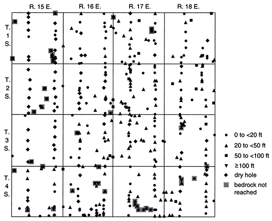
Where water was reported in drill holes in Doniphan County, it was less than 100 ft (30 m) deep (fig. 25). The four greatest water depths [75-95 ft (23-29 m)] were found in upland areas where the depth to bedrock is more than 100 ft (30 m). However, water levels under apparently similar conditions may be as shallow as 10 ft (3 m). For all the glacial deposits the depth to water was 3-95 ft (0.9-29 m), and more than half of the values were greater than 30 ft (9 m). The depth to water in alluvial deposits was generally shallower, with most values between 5 ft (2 m) and 25 ft (7.6 m).
Figure 25--Depth to water in wells and test wells, Doniphan County.
The saturated thickness of unconsolidated deposits in Doniphan County (fig. 26) is greatest in the buried drainageway along the border between T. 2 S., R. 19 E., and T. 3 S., R. 19 E., where it is 133 ft (40.5 m), and in the Missouri River valley, where it is 107 ft (32.6 m). In the Wolf River saturated alluvial deposits generally range from 30 ft to 60 ft (9-18 m) in thickness. In the smaller stream valleys, thicknesses less than 20 ft (6 m) are common. The thickness of saturated glacial deposits is generally greater than 15 ft (5 m), and most values from borehole data are more than 30 ft (9 m).
Figure 26--Saturated thickness of Pleistocene deposits, Doniphan County.
As Bayne (1973) observed, almost any area in Doniphan County with 30-40 ft (9-12 m) of saturated Pleistocene deposits will provide sufficient water for domestic and stock supplies to a well obtaining water from at least one thin saturated sand or gravel layer. He also noted that in the uplands the most productive aquifers do not necessarily coincide with the greatest saturated thicknesses. The buried valleys or other areas with saturated sand and gravel deposits are capable of supplying the largest quantities of ground water.
Douglas County
Geology
The geology of Douglas County has been well described and mapped by O'Connor (1960, 1992). The regional structure is dominated by the Prairie Plains homocline, and post-Permian rocks dip northwestward at 20 ft/mi (4 m/km). The homocline has many smaller synclinal and anticlinal structures superimposed on it. Several faults have been mapped in the southern part of the county. Oil and gas fields have been developed in the eastern part of the county, primarily from the Cherokee and Pleasanton Groups, at depths between 340 ft (100 m) and 800 ft (240 m).
As described by O'Connor (1960), the bedrock units exposed in Douglas County range from the Lansing Group (oldest) to the Shawnee Group (youngest). Sixtyfive to 100 ft (20-30 m) of rocks of the Lansing Group, including limestone, shale, sandstone, and some coal, are exposed along drainageways in the northeastern part of the county (fig. 5). The total thickness of the sandstone, shale, limestone, and coal of the overlying Douglas Group ranges from about 150 ft to 450 ft (46-140 m). Locally the group contains two major channel sandstones. The valley in which the Tonganoxie Sandstone Member was deposited extends from the northeast corner to the southwest corner of the county, and the Ireland Sandstone Member fills a former valley located in the southern part of the county. The two sandstones may be 120 ft (37 m) and 150 ft (46 m) thick, respectively. The youngest bedrock units exposed in Douglas County include 300-375 ft (90-114 m) of Shawnee Group limestones and shales with some sandstone, siltstone, and coal.
The total thickness of exposed Pennsylvanian and Quaternary units in Douglas County is 1,000 ft (300 m) (O'Connor, 1960). The southern limit of glaciation in Kansas apparently crossed the county (figs. 7 and 9). Surficial deposits include till, glaciofluvial and glaciolacustrine sediments, loess, and alluvium (fig. 9).
Pre-Illinoian glacier-related deposits occur primarily in the northern half of Douglas County, especially in the northeastern Hesper plain area (O'Connor, 1960). The oldest Quaternary sediments are leached and oxidized gravels (composed primarily of chert but including up to 40% erratics locally) in a reddish sandy clay matrix. The chert gravels are probably preglacial stream deposits, and the gravels with both chert and erratics may reflect reworking by ice or glacial meltwater.
Glacial till in Douglas County has been described and mapped by O'Connor (1960). The till is generally unstratified and unsorted, but stratified sand and gravel occurs locally within till in uplands or grades into till in other areas. Between the Kansas and Wakarusa rivers, most of the till is clay, and O'Connor (1960, p. 50-52) suggested that it "probably accumulated by lodgement from the base of the ice. . . . Other till deposits accumulated by dumping or being let down by slow wastage of the ice (superglacial ablation moraine)," and the latter deposits have relatively less clay and silt and more sand and gravel because of washing by meltwater.
Glaciofluvial and glaciolacustrine deposits occur in all topographic positions in northern Douglas County, as described and mapped by O'Connor (1960), who assigned these deposits to the Kansan Atchison, Grand Island, and Sappa formations. Some of the stratified materials originally may have been till that was reworked by meltwater. O'Connor (1960, p. 52) concluded that "the predominance of stratified deposits rather than till in the terminal area of the glacier indicates that the Kansan glacier at its climax may have been a slowly flowing, rapidly melting ice mass." The ice probably extended at least as far south as the Wakarusa River valley (O'Connor, 1960; Todd, 1909; Schoewe, 1930a, b; Aber, 1991).
South of the Wakarusa River, stratified gravel deposits, 2-30 ft (0.6-9 m) thick, occur on some topographic highs (O'Connor, 1960). The deposits consist of poorly sorted sand and gravel. Where thin, the material is leached and includes primarily chert, quartz, and igneous and metamorphic rocks from the northern United States and southern Canada. Where thick, the deposits are leached only in the upper part and are dominated by limestone and other local rock types. The areal distribution and the character of the sediments indicate that the material was deposited at the ice margin, probably by streams flowing on bedrock along the glacier front or on or within the ice in marginal crevasses (O'Connor, 1960).
Just north of the present Wakarusa River valley (which probably developed before its direct glaciation) and extending for several miles from the western border of Douglas County are deposits of an east-flowing stream that may have been englacial or subglacial (O'Connor, 1960). The deposits consist of up to 40 ft (12 m) of gravel, sand, and silt that now form a ridge where they have not been eroded. Continuing eastward, the deposits underlie the town of Clinton and fill an abandoned valley. South of Lawrence, the deposits again form a ridge, with boulders, gravel, and sand in the lower and middle parts and finer-grained material in the upper zone. At least locally, till overlies the stratified deposits south of Lawrence. The history of the Wakarusa River valley is undoubtedly complex, with episodes of entrenchment, coverage by ice, and alluviation. As the ice receded, the Kansas River valley probably developed further and captured much of the Wakarusa drainage.
Glaciolacustrine silt and sand were deposited in lakes that developed from blockage or derangements of drainage by ice or glacial deposits. O'Connor (1960) has described several such lacustrine deposits, including those in SW sec. 2, T. 13 S., R. 19 E., and SE sec. 8, T. 14 S., R. 21 E., where the sediments range up to 7 ft (2 m) in thickness. These deposits include at least 24 pairs of varves and locally are covered by till. Although O'Connor (1960) believed that many temporary lakes were formed in Douglas County, he suggests that the lacustrine deposits are now rare, probably because they were thin, destroyed by glaciation, and/or subsequently eroded where not topped by a protective cover of till or gravel. This perspective was also expressed by Dort (1985) and Aber (1991).
The northeastern part of Douglas County (the Hesper plain area south of the Kansas River and east of Little Wakarusa Creek) contains extensive glacial, glaciofluvial, and glaciolacustrine deposits, except where they have been eroded by streams (O'Connor, 1960). Schoewe (1930a, b) and Hoover (1936) classified the deposits as reworked till, whereas Dufford (1958) considered the material in the northern half of the area to be part of the Menoken terrace (outwash from a retreating "Kansan" glacier; Davis and Carlson, 1952). O'Connor (1960) cited till deposits in sec. 17, T. 14 S., R. 21 E., as evidence that the glacier extended at least this far south. Within the general Hesper plain area the deposits, as described by O'Connor (1960), commonly include a basal layer of gravel or sand that ranges from well sorted to poorly sorted and from clean to clayey. The upper part of the deposits commonly consists of clayey and silty sand or sandy clay with some gravel and cobbles. Locally, however, the entire sequence of material contains only unstratified sandy and gravelly silt and clay.
The preglacial topography of the Hesper plain area was a lowland developed on Douglas Group shales and sandstones, with higher (more resistant) limestones on the east and west sides (O'Connor, 1960). The surface and base of the Quaternary sediments deposited on this lowland rise 100 ft (30 m) over a distance of7.5 mi (12 km) toward the south from altitudes of 885 ft (270 m) and 855 ft (261 m), respectively, along the south bluff of the Kansas River. The difference between this northeastern area and the remainder of the county is clearly visible on Landsat imagery (e.g., Image ID 246716171, path 29, row 33, May 3, 1976, where the region appears blue-gray on the false-color composite).
The Kansas River valley changed significantly during glaciation. Lohman and Frye (1940) thought that the modern Kansas River originated during the advance of the Kansan glacier and was an ice-marginal drainageway. When the ice crossed and blocked the Kansas River, the Wakarusa River may have served as a spillway for meltwater (Todd, 1911). As the glacier retreated to north of the Kansas River, meltwater carried gravels and later finer-grained sediments into the valley, where locally more than 60 ft (18 m) of leached and oxidized reddish-brown sand, silt, and clay were deposited above 20 ft (6 m) of coarse, poorly sorted gravel (O'Connor, 1960). Most of these deposits were subsequently eroded from the valley, but (Menoken) terrace deposits remain along the southern side of the Kansas River between Baldwin Creek and Lawrence and directly opposite this area on the northern side of the valley.
As described by O'Connor (1960), the Illinoian Stage in Douglas County included erosion of deposits in the Kansas River valley and its tributaries, entrenchment of the river 50-60 ft (15-18 m) below basal Kansan deposits, and then at least 70 ft (21 m) of aggradation. Buck Creek terrace deposits represent late Illinoian time and include coarse-grained basal deposits and reddish or tan silt, sandy silt, and clay in the upper part. The reddish Sangamon soil is well developed on Buck Creek terrace deposits.
Loess deposits are minor in Douglas County. As described by O'Connor (1960), thin [generally less than 5 ft (2 m)] loess of the Loveland loess (Illinoian) occurs locally in bluffs bordering the Kansas River valley, and thin [less than 5 ft (2 m)], discontinuous deposits of the Wisconsinan Peoria formation can be found on uplands. The Peoria loess is thickest [locally 5-10 ft (2-3 m)] along the bluffs of the Kansas River Valley.
During early Wisconsinan time, the bedrock floor of the Kansas and Wakarusa River valleys was eroded to 20-50 ft (6-15 m) below the basal Illinoian deposits, and alluviation produced deposits that underlie the Newman terrace, the surface of which is generally 30-40 ft (9-12 m) below the Buck Creek terrace (O'Connor, 1960). In the Kansas River valley the Newman terrace deposits include cobbles and gravel overlain by sand to clayey silt. The basal deposits are coarser than the sediments presently carried by the river, but the upper 40 ft (12 m) of the deposits are similar (Davis and Carlson, 1952). In the Wakarusa River valley, the Newman terrace deposits are dominated by silt and clay.
Within Douglas County the Kansas River floodplain ranges from 2.5 mi to 3 mi (4-5 km) in width, except where it narrows near the Johnson County line. The Wakarusa River valley is generally 1-1.5 mi (2-2.4 km) wide. Most other valleys in the county are less than 0.5 mi (0.8 km) wide, although parts of the Rock and Washington Creek valleys are wider. As noted by O'Connor (1960), slightly less than half of the Kansas River floodplain west of Eudora is Newman terrace, whereas the balance is late Wisconsin and Holocene alluvium. In the Wakarusa River valley and along many other Kansas River tributaries, the Newman terrace forms at least 90% of the floodplain.
In the Kansas River valley the late Wisconsin and Recent alluvium consists primarily of sand and silt. Several investigators have suggested that there may be additional terrace surfaces between the alluvium and the Newman terrace (O'Connor, 1960).
The bedrock topographic map of Douglas County (plate 1) was prepared using data from 370 drill-hole logs (Denne et al., 1990a), geologic maps (O'Connor, 1960; Ward and O'Connor, 1983), and a metric topographic map (U.S. Geological Survey, 198Ia). Where bedrock is exposed at the land surface, the surface and bedrock topography are equivalent.
There are no major buried valleys in Douglas County. Till and glaciofluvial deposits occur on the Hesper plain area of T. 13 and 14 S., R. 21 E.; these deposits slope generally northward toward the Kansas River valley. At some time, more of the drainage may have flowed south toward Captain Creek, or Captain Creek may cut glaciofluvial deposits that were once more extensive [note the wide area of stream deposits and thick (7-13 ft; 2-4 m) sand in sec. 15, T. 14 S., R. 21 E.]. The Wakarusa River is currently underfit for the size of its valley (indicating that it once carried more drainage), and the bedrock floor is at approximately the same elevation as in the Kansas River valley to the north. The buried segment of a former subglacial (?) channel, as previously described, underlies the area near the town of Clinton in approximately the center of T. 13 S., R. 18 E.
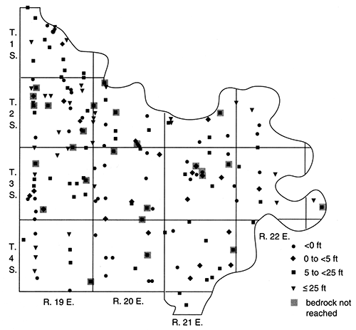
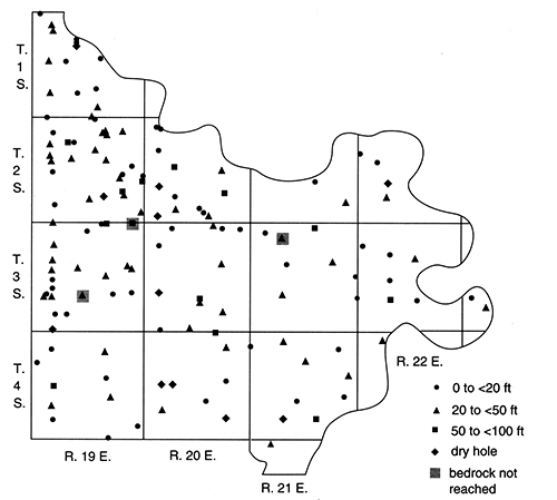
The depth to bedrock in Douglas County (fig. 27) ranges up to 136 ft (41.5 m). A log for an oil test in SW NE NE sec. 21, T. 13 S., R. 19 E., indicates the presence of sand and gravel from 80 ft to 136 ft (24-41.5 m) at this site in the valley where the modern Wakarusa River and Washington Creek join. If the depth and elevation of bedrock at this site are correct, then a narrow, deep channel must underlie the Wakarusa and Kansas River valleys or meltwater near the ice margin created a large local depression. A record for a water well in NE SW sec. 13, T. 13 S., R. 19 E., shows that the depth to bedrock elsewhere in the Wakarusa River valley is at least 85 ft (26 m). The other two largest values for depth to bedrock in the county are in the Kansas River valley, where a somewhat ambiguous log for a borehole in SW SE NE sec. 35, T. 12 S., R. 20 E., indicates bedrock between 81 ft (25 m) and 101 ft (30.8 m), and in a well in NE SW NE sec. 8, T. 12 S., R. 20 E., where the bedrock is 90 ft (27 m) deep.
Figure 27--Depth to bedrock, Douglas County.
The thickness of deposits in the Kansas River valley below areas mapped by O'Connor (1960) as alluvium is generally 40-75 ft (12-23 m), with the majority of values between 40 ft (12 m) and 60 ft (18 m). Deposits underlying the Newman terrace (Wisconsin-Holocene; Davis and Carlson, 1952) in the Kansas River valley tend to be somewhat thicker, with values commonly ranging from 40 ft to 90 ft (12-27 m) and more than half of the thicknesses being greater than 60 ft (18 m). The thickest stream deposits generally occur near the Kansas River junctions with the Mud Creek and Wakarusa River valleys.
Deposits mapped as the Newman terrace or undifferentiated terrace (O'Connor, 1960) along drainages other than the Kansas River in Douglas County range from 10 ft to 70 ft (3-21 m) in thickness. Along the Wakarusa River and Washington Creek, thicknesses are typically 30-70 ft (9-21 m), although they can reach 136 ft (41.5 m) (SW NE NE sec. 21, T. 13 S., R. 19 E., as previously described). Stream deposits range from 20 ft to 50 ft (6-15 m) in thickness along Rock Creek, from 15 ft to 37 ft (5-11 m) along Coal Creek, and from 20 ft to 30 ft (6-9 m) along Captain Creek.
The depth to bedrock is as much as 32 ft (9.8 m) below the Newman terrace deposits along Baldwin Creek, but it ranges from 26 ft to 53 ft (7.9-16 m) below the Buck Creek terrace (Illinoian; Davis and Carlson, 1952) between Baldwin Creek and the Kansas River valley, as mapped by O'Connor (1960). Along the Wakarusa River the Buck Creek terrace is 50-85 ft (15- 26 m) thick, and along Washington Creek it is at least 35 ft (11 m) thick.
The depth to bedrock below glacial and glaciofluvial deposits in Douglas County ranges up to 66 ft (20 m), with approximately half of the data points between 10 ft (3 m) and 30 ft (9 m) (fig. 27). The channel deposits in the northern half of T. 13 S., R. 17 E., are up to 48 ft (15 m) in thickness and in the center of T. 13 S., R. 18 E., up to 28 ft (8.5 m) thick. Just south of the Kansas River valley, from Baldwin Creek to Lawrence, outwash deposits (of the Menoken terrace) range from 10 ft to 66 ft (3-20 m) thick; just opposite, to the north of the river, these deposits are 44-62 ft (13-19 m) thick. From the southern side of Lawrence southward to the Wakarusa River valley, outwash deposits range from 24 ft to 50 ft (7.3-15 m) thick.
East of Lawrence, between the Kansas and Wakarusa rivers, glacial till and glaciofluvial deposits generally are between 20 ft (6 m) and 60 ft (18 m) thick. In the Hesper plain area the depth to bedrock ranges up to 58 ft (18 m), although more than half of the values are between 15 ft (5 m) and 35 ft (11 m).
Of the 157 data points in areas mapped as bedrock in Douglas County, 90% (141) indicate that the depth to bedrock is less than 20 ft (6 m). The surficial materials at these sites may include thin glacial, glaciofluvial, or loess deposits or residuum.
The total thickness of sand and gravel in Douglas County (fig. 28) is greatest in the Kansas River valley, where it ranges up to 83 ft (25 m). The maximum value occurs in the Newman terrace [as mapped by O'Connor (1960)] in SW SE NE sec. 7, T. 12 S., R. 20 E., where Mud Creek enters the valley, and another large value [64 ft (20 m)] occurs nearby in the alluvium near the edge of the Newman terrace in NE NE NW sec. 20, T. 12 S., R. 20 E. The questionable log for a borehole in SW SE NW sec. 35, T. 12 S., R. 20 E., indicates between 76 ft (23 m) and 82 ft (25 m) of sand and gravel in the alluvium between the junctions of the Kansas River with the Mud Creek and Wakarusa River valleys. A test hole in the alluvium in SE SE NE sec. 9, T. 12 S., R. 19 E. (near Lakeview), shows 68 ft (21 m) of sand and gravel. Of these four sites, sand and gravel make up the full thickness of unconsolidated sediments at two sites and all but the upper 5-8 ft (2-2.4 m) at the other two sites.
Figure 28--Total Pleistocene sand and gravel thickness, Douglas County.
In general, logs for 50 wells in the Kansas River valley alluvium indicate a range in total sand and gravel thickness of 13-82 ft (4.0-25 m), with the majority between 30 ft (9 m) and 50 ft (15 m). Twenty-five drill holes in the Newman terrace of the Kansas River valley suggest a range of 0-83 ft (0-25 m) for total sand and gravel thickness, with the majority again between 30 ft (9 m) and 50 ft (15 m). The alluvial and terrace material typically becomes coarser with depth, with fine- to medium-grained sand near the land surface and gravel or sand and gravel above bedrock. Intermediate layers of coarser sand and/or gravel sometimes "interrupt" the downward progression from fine to coarse grained. The thickness of the basal gravel layer ranges up to 45 ft (14 m) in SE NE NE sec. 28, T. 12 S., R. 20 E., with other large values [greater than 29 ft (8.8 m)] in NW SE SE sec. 17, T. 12 S., R. 20 E.; NW SE NE sec. 21, T. 12 S., R. 20 E.; SE SW sec. 2, T. 13 S., R. 20 E.; and NW NW NW sec. 7, T. 13 S., R. 21 E.-all of which are between the junctions of the Kansas River with the Mud Creek and Wakarusa River valleys.
In deposits mapped by O'Connor (1960) as the Newman terrace or undifferentiated terrace elsewhere in Douglas County, the total sand and gravel thickness ranges from 0 to 56 ft (17 m). The maximum value from an oil log in SW NE NE sec. 21, T. 13 S., R. 19 E., however, is questionable. As previously discussed, the sand and gravel reported from 80 ft to 136 ft (24-41.5 m) (if accurate) may indicate a deep, narrow channel underlying the Washington Creek valley near its junction with the Wakarusa River. In Rock Creek the total thickness of sand and gravel ranges from 2 ft to 45 ft (0.6-14 m), with the largest value consisting of 40 ft (12 m) of sand underlain by 5 ft (2 m) of gravel in SW NE sec. 27, T. 13 S., R. 18 E. Ten logs in the Wakarusa River valley indicate 0-14 ft (0-4.3 m) of sand and gravel, with a mean value of 6 ft (2 m). In both the Coal Creek and Captain Creek drainages, the total sand and gravel thickness ranges from 0 to 13 ft (4.0 m) and has a mean value of 7 ft (2 m).
Six logs for drill holes in the Buck Creek terrace [as mapped by O'Connor (1960)] in the Wakarusa River valley indicate a total sand and gravel thickness of 0-30 ft (0-9 m). In SW NW sec. 20, T. 13 S., R. 20 E., fine-grained sand occurs from 32 ft to 60 ft (9.8-18 m) in depth. South of Lawrence (NE SW sec. 13, NE NE sec. 14, and SW SW NW sec. 13, T. 13 S., R. 19 E.), sand and gravel make up the lower 4-30 ft (1-9 m) of the unconsolidated deposits. In the Buck Creek terrace between Baldwin Creek and the Kansas River, 1-9 ft (0.3-3 m) of sand and gravel or sand overlie bedrock at two sites.
The total thickness of sand and gravel in the till and outwash deposits in Douglas County is 0-50 ft (0-15 m). The largest value occurs in the Hesper plain area (NE NE sec. 3, T. 14 S., R. 21 E.), where 32 ft (9.8 m) of coarse-grained sand overlies 18 ft (5.5 m) of fine-grained sand above bedrock. The second largest value [38 ft (12 m)] occurs nearby in SW SW SW sec. 3, T. 14 S., R. 21 E. Other sand and gravel thicknesses in the Hesper plain area are less than 25 ft (7.6 m), and the mean for 24 values is 12 ft (3.7 m). Thirteen of the sites have a gravel or sand and gravel layer [ranging from 1 ft to 18 ft (0.3-5.5 m) thick and having a mean of 6 ft (2 m)] overlying bedrock. Layers of sand are commonly fine- to medium-grained.
In the outwash deposit (Menoken terrace) along the northern edge of the Kansas River (T. 12 S., R. 20 E.), four drill holes indicate 10-24 ft (3-7.3 m) of sand or sand and gravel. Directly opposite the Kansas River from these sites (between Baldwin Creek and Lawrence), eight logs show 0-30 ft (0-9 m) of sand and gravel, although seven of the sites have 10 ft (3 m) or less. In the outwash deposits between Lawrence and the Wakarusa River, the total sand and gravel thickness ranges from 0 to 8 ft (2.4 m), whereas in the outwash and till between the Wakarusa and Kansas rivers east of Lawrence, sand and gravel make up 0-15 ft (0-4.6 m) of the deposits. One site (SW SW sec. 12, T. 13 S., R. 17 E.) in the former channel near the western border of the county contains 25 ft (7.6 m) of fine-grained sand. The outwash deposits near Clinton include up to 11 ft (3.4 m) of a basal sand and gravel (NW NW NE sec. 22, T. 13 S., R. 18 E.).
In the southern part of the county and in other areas where bedrock occurs at or near the land surface, there are no sand and gravel deposits.
Ground Water
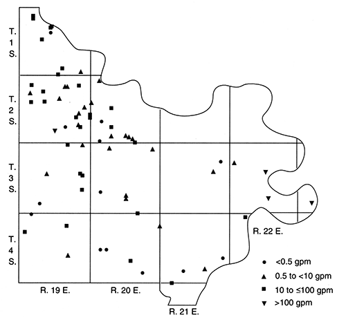
Ground-water availability in Douglas County varies widely. Reported well yields, uncorrected for such factors as well diameter, are shown in fig. 29, which clearly indicates that the large supplies come from deposits in the Kansas River valley. Of 24 wells in the Kansas River alluvium with reported yields, 14 produce at least 200 gpm (0.01 m3/s) and six of these yield 1,000-3,000 gpm (0.06-0.2 m3/s). The remaining 10 wells yield 7-60 gpm (0.0004-0.004 m3/s). Two wells in the Newman terrace deposits of the Kansas River valley yield 50 gpm (0.003 m3/s) and 100 gpm (0.006 m3/s), whereas six others produce 350-2,000 gpm (0.022-0.13 m3/s). The largest yields in the county [>1,000 gpm (>0.06 m3/s)] are reported near Lakeview and between the junctions of the Kansas River with the Mud Creek and Wakarusa River valleys (NW NW NE sec. 9 and NE NW SW sec. 10, T. 12 S., R. 19 E.; NESW sec. 20, SW SW NW sec. 20, NW SE NE sec. 21, NE NW NW sec. 21, SE NE NE sec. 28, and SW NE NE sec. 33, T. 12 S., R. 20 E.).
Figure 29--Estimated well yields, Douglas County.
Although a well in NE NE sec. 10, T. 13 S., R. 21 E., in the Captain Creek drainage yields 30 gpm (0.002 m3/s), Newman terrace deposits in other stream valleys generally yield 2-10 gpm (0.0001-0.0006 m3/s) where the material is saturated. Larger values occur locally where underlying bedrock contributes all or part of the water to the wells (e.g., NE sec. 33, T. 13 S., R. 18 E., and SW SW sec. 21, T. 13 S., R. 20 E.). O'Connor (1960) speculated that yields of 50-100 gpm (0.003-0.006 m3/s) could be obtained from deposits along the Wakarusa River but that it would be difficult to screen and develop wells to prevent pumpage of sand and silt. In the lower parts of the Little Wakarusa and Captain creeks, where stream deposits are at least 30 ft (9 m) thick and contain a basal sand and gravel layer, O'Connor (1960) also estimated potential yields of 10-50 gpm (0.0006-0.003 m3/s).
Reported yields from the Buck Creek terrace deposits in Douglas County include 10 gpm (0.0006 m3/s) near Baldwin Creek and 15 gpm (0.00095 m3/s) and 40 gpm (0.0025 m3/s) in the area between Lawrence and the Wakarusa River. However, the first and third of these values also include contributions from underlying sandstone bedrock. Although the basal sand and gravel is generally poorly sorted and contains silt and clay, O'Connor (1960) suggested that 25-50 gpm (0.0016-0.003 m3/s) could be produced from properly constructed and developed wells in the Buck Creek terrace.
Most of the wells completed in till or outwash deposits that have reported yields also obtain water from underlying bedrock units. It is therefore difficult to estimate the quantity of water available from the pre-Illinoian Pleistocene sediments. In the Hesper plain area, several wells yield 0-20 gpm (0-0.001 m3/s), with three values in the range 2-4 gpm (0.0001-0.0003 m3/s). The 20-gpm (0.001-m3/s) yield was reported from fine-grained, dirty sand in NW NW SW sec. 17, T. 13 S., R. 21 E. O'Connor (1960) stated that saturated sand and gravel in the Hesper plain area probably could yield 50 gpm (0.003 m3/s) locally. Areas with undissected outwash of adequate areal extent (e.g., the Menoken terrace between Baldwin Creek and Lawrence and the deposits between the Kansas and Wakarusa rivers to the south and east of Lawrence) may yield up to several gallons per minute.
Based on data from 87 drill holes in areas mapped as bedrock (not including wells penetrating multiple aquifers), seven were reportedly dry and 10 have yields of less than 1 gpm (0.00006 m3/s). Another 33 wells have yields of 1-5 gpm (0.00006-0.0003 m3/s), and 30 others have yields of 6-25 gpm (0.0004-0.0016 m3/s). Yields from the other seven sites have values in the range 30-50 gpm (0.002-0.003 m3/s). The larger values are associated with the Tonganoxie and Ireland Sandstone Members.
O'Connor (1960) described the bedrock aquifers in Douglas County. When near-surface limestones and shales are weathered so that joints, fractures, and bedding planes are enlarged, these units locally provide small supplies of water to shallow wells. Water levels in these wells may fluctuate greatly over time, however, and in dry years the wells may go dry. Thin [5-30 ft (2-9 m) locally] fine-grained sandstones of the Calhoun, Tecumseh, and Kanwaka Shales may yield up to 2 gpm (0.0001 m3/s). The Ireland Sandstone Member of the Lawrence Formation is an important aquifer in southern Douglas County; it commonly yields 5-50 gpm (0.0003-0.003 m3/s) and could possibly produce 100 gpm (0.006 m3/s) where conditions are favorable. Locally, the Ireland Sandstone Member is more than 115 ft (35 m) thick and as much as 100 ft (30 m) of the unit may be saturated. The Tonganoxie Sandstone Member of the Stranger Formation is the other major bedrock aquifer in the county, and it extends from the northeast border to the southwest border. The sandstone is locally as thick as 70 ft (21 m) and generally yields 5-50 gpm (0.0003-0.003 m3/s), although where most permeable, it could produce 50-100 gpm (0.003-0.006 m3/s). The Vinland Shale Member, also of the Stranger Formation, locally contains a thin, calcareous sandstone that yields small amounts of water to some wells. Both the Rock Lake Shale Member of the Stanton Limestone and the Bonner Springs Shale locally contain thin [less than 16 ft (4.9 m)] sandstone that yields 1-10 gpm (0.00006-0.0006 m3/s). The quality of water from bedrock aquifers in Douglas County varies considerably, from good to unusable.
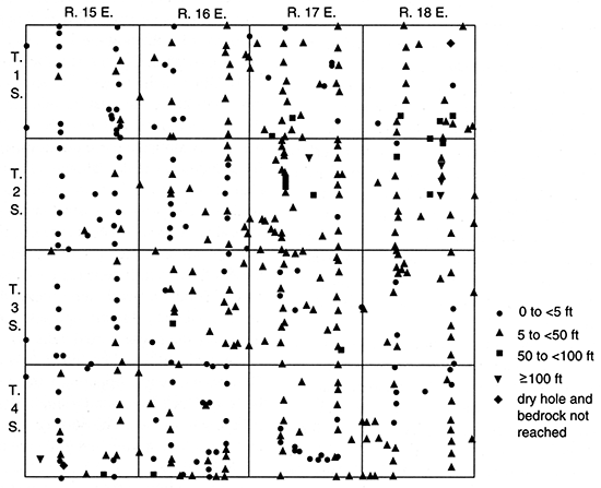
Figure 30 illustrates the depth to water in wells in Douglas County. When analyzing these data, it is important to remember that they represent values from many different seasons and years and that some indicate the water table, some the piezometric surface of various confined aquifers, and others the composite level from multiple aquifers. Nevertheless, some generalizations can be made. The greatest depths to water occur in bedrock units, especially those in the southwestern and central parts of the county. For example, values between 200 ft (60 m) and 360 ft (110 m) are found in SE NE SE sec. 35, T. 13 S., R. 19 E.; SE SE sec. 24, SW SE NE sec. 25, and SE NE sec. 35, T. 14 S., R. 17 E.; SW SE sec. 32, T. 14 S., R. 18 E.; and SW NE sec. 1, T. 15 S., R. 17 E. Water levels in other bedrock wells, however, cover nearly the full range of depths to a minimum of 4 ft (1 m). Where saturated, water levels in the pre-Illinoian till and outwash range from 3 ft to 109 ft (0.9-33.2 m), although most values over 40 ft (12 m) reflect water levels combined with underlying bedrock units. In the Buck Creek terrace, the depth to water in a well near Baldwin Creek is 14 ft (4.3 m), and it is between 10 ft (3 m) and 44 ft (13 m) in four wells in the Wakarusa River Valley. The depth to water in Newman terrace deposits in the Kansas River valley may be as shallow as 6 ft (2 m), but almost all other values are between 20 ft (6 m) and 30 ft (9 m). Along tributaries, water levels in Newman or undifferentiated terrace deposits are generally between 5 ft (2 m) and 25 ft (7.6 m). The depth to water in 57 wells in the Kansas River valley alluvium ranges from 3 ft to 40 ft (0.9-12 m), with 80% (46) of the values between 10 ft (3 m) and 30 ft (9 m). The greater depths occur in areas where many wells pump water from the alluvial aquifer (e.g., near Lawrence).
Figure 30--Depth to water in wells and test wells, Douglas County.
The same factors that limit the usefulness of the depth to water data must also be considered in calculating the saturated thicknesses of unconsolidated deposits. The saturated thickness of Pleistocene deposits in Douglas County is shown in fig. 31. The largest values [up to 63 ft (19 m) in SE SE SE sec. 8, T. 12 S., R. 20 E.] occur in Newman terrace deposits and alluvium in the Kansas River valley, particularly near Lakeview and in the area where Mud Creek enters the valley. The saturated thickness of alluvium in the Kansas River valley ranges from 20 ft to 60 ft (6-18 m), with 19 of 57 values between 30 ft (9 m) and 40 ft (12 m). The Newman terrace in the Kansas River valley appears to have a slightly greater saturated thickness, with 11 (60%) of 18 values between 50 ft (15 m) and 63 ft (19 m) and most others between 30 ft (9 m) and 40 ft (12 m). Although the saturated thickness of some Newman terrace deposits in the Wakarusa River valley ranges from 0 to 10 ft (3 m), most values are between 35 ft (11 m) and 50 ft (15 m). One value in the Washington Creek valley is 44 ft (13 m), and saturated thicknesses along three other Wakarusa River tributaries range up to 27 ft (8.2 m) in two tributaries and 15 ft (4.6 m) in the third.
Figure 31--Saturated thickness of Pleistocene deposits, Douglas County.
Three saturated thickness values of 15 ft (4.6 m) occur in the Captain Creek terrace deposits. In Baldwin Creek the values are as great as 22 ft (6.7 m). In other stream valleys throughout the county the saturated thickness of Newman and undifferentiated terrace deposits is generally 0-10 ft (0-3 m). Saturated thickness values for the Buck Creek terrace include 6 ft (2 m), 44 ft (13 m), 54 ft (16 m), and 55 ft (17 m) along the Wakarusa River and 12 ft (3.7 m) near Baldwin Creek. Glacial till and outwash deposits in the Hesper plain area have saturated thicknesses ranging from 0 to 42 ft (13 m). Except for two large values [25 ft (7.6 m) and 42 ft (13 m)] in SW SW NW sec. 27, T. 13 S., R. 21 E., and SW SE SE sec. 4, T. 14 S., R. 21 E., data points generally show 5-15 ft (2-5 m) of saturated thickness. Between the Kansas and Wakarusa rivers, to the south and east of Lawrence, the saturated thickness of the till and outwash deposits is 15 ft (5 m) or less, with many of the sediments here and elsewhere in the county being dry or having no permeable saturated zones.
Because of the problems with depth to water measurements previously described, water-level data must be used with some caution. However, it is clear that ground water flows with an average hydraulic gradient of 2-3 ft/mi (0.4-0.6 m/km) from northwest to southeast along the Kansas River valley. The general flow pattern and gradient are interrupted locally by the dam at Lawrence and by areas with heavy ground-water pumpage.
O'Connor (1960) estimated that the average hydraulic gradient of the water table in the alluvium and terrace deposits of the Wakarusa River valley is 4 ft/mi (0.8 m/km). O'Connor (1960) also estimated that the average hydraulic gradient in a portion of the artesian part of the Tonganoxie Sandstone Member is 7 ft/mi (1.3 m/km) and that water moves from the southwestern part of the county northeastward toward Lawrence, where it discharges into the stream deposits of the Wakarusa and Kansas River Valleys.
Characteristics for some of the major aquifers in Douglas County have been described by O'Connor (1960). In the alluvium and Newman terrace deposits of the Kansas River valley, the coefficient of permeability is generally more than 1,000 gpd/ft2 (40 m/d) and is locally more than 12,000 gpd/ft2 (490 m/d). Transmissivity values range up to 354,000 gpd/ft2 (4400 m2/d) (as reported for a well in SE SE sec. 1, T. 12 S., R. 19 E.). Specific capacities range from 14 gpm/ft to 175 gpm/ft (0.0029-0.0362 m2/s) of drawdown. In the well-sorted massive portions of the Ireland Sandstone Member, the coefficient of permeability ranges from 100 gpd/ft2 to 350 gpd/ft2 (4-14 m/d), but elsewhere it is commonly 25-150 gpd/ft2 (1.0-6.1 m/d). The specific capacities for two wells are 1 gpm/ft (0.0002 m2/s) and 7.6 gpm/ft (0.0016 m2/s) of drawdown. The coefficient of permeability for the Tonganoxie Sandstone Member generally ranges from 15 gpd/ft2 to 150 gpd/ft2 (0.61-6.1 m/d).
In Douglas County the largest quantities of water can be obtained from the Kansas River valley alluvium and terrace deposits and from the Ireland and Tonganoxie Sandstone Members. However, the quality of water, especially from the bedrock units, must be evaluated before a supply is developed.
Ground-water discharge in Douglas County is to streams, wells, evapotranspiration, and springs, whereas recharge is primarily from precipitation, influent seepage from surface water, and subsurface inflow (O'Connor, 1960). Lohman (1941) estimated that the annual recharge in the Kansas River valley is 64 million gal/mi2 (94 million L/km2) based on 10% precipitation.
Jackson County
Geology
The surface geology of Jackson County was mapped by Walters (1953). Pennsylvanian bedrock is exposed locally in the eastern part of the county, and Permian limestones and shales occur in the west and northeast (fig. 5). Thick glacial deposits cover the northern and east-central areas of the county, and alluvium overlies the older deposits where they have been crossed by modern streams (fig. 9).
A map of the bedrock topography (plate 1) was contoured using data from 530 well logs (Denne et al., 1990a), the county maps of the geology (Walters, 1953), and surface topography (U.S. Geological Survey, 1981b). Drainage on the bedrock surface, as indicated in R. 12 E. and R. 13 E. and in the southern half of the county, is primarily a reflection of modern streams. Buried valleys dominate the bedrock topography in the north. The major buried channel extends from northwest to southeast in T. 5 S., R. 15 E., and T. 6 S., R. 16 E. Several buried tributaries enter the main valley from the west in T. 6 S., and Elk Creek (at the border of T. 6 S. and T. 7 S.) appears to overlie older drainage. Several bedrock highs in T. 5 S. and T. 6 S. may have influenced the position of the ice margin and its drainage. Referring to the buried valley mapped in Jackson and Nemaha counties in 1950, Frye and Walters (1950, p. 157) "judged that this bedrock 'sag' probably represents a . . . valley eroded in marginal position to the . . . ice front." They specified that the valley developed along the Nebraskan ice front and was overridden by the Kansan glacier, but the age terminology is now in question.
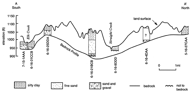
The depth to bedrock in Jackson County (fig. 32) is as great as 226 ft (68.9 m) beneath the main buried valley. Deposits filling the channels generally include a basal gravel [less than 20 ft (6 m) thick] overlain by layers of fine-grained sand and silty clay till with local sand and gravel lenses. The total thickness of sand and gravel deposits can exceed 100 ft (30 m) (fig. 33). A cross section roughly perpendicular to the main channel (A-A' on fig. 34 and plate 1) illustrates the range of sediment types and thicknesses.
Figure 32--Depth to bedrock, Jackson County.
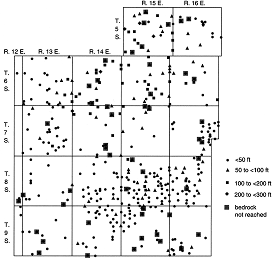
Figure 33--Total Pleistocene sand and gravel thickness, Jackson County.
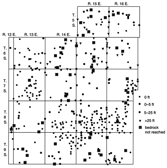
Figure 34--Cross section A-A' showing surface topography and drill-hole data. Location of section shown in plate 1.
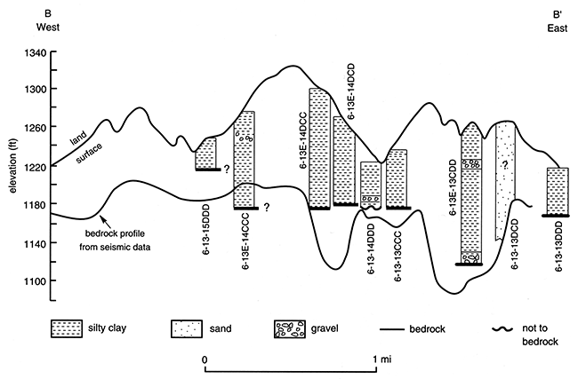
Seismic profiles were made across three small buried valleys in Jackson County to evaluate the channel widths and orientations. A test hole drilled in 1950 in SE SE SW sec. 13, T. 6 S., R. 13 E., had 12 ft (3.7 m) of gravel below 138 ft (42.1 m) of glacial deposits, suggesting the presence of a buried valley despite bedrock exposures 0.5 mi (0.8 km) to the north. The land-surface topography and the bedrock surface, as interpreted from seismic data for the line B-B' are shown in fig. 35, and the location of the profile is shown on plate 1. Although it is probably not quite perpendicular to the buried valley, the seismic profile indicates that the channel (near B') is 180 ft (55 m) deep and 0.5 mi (0.8 km) wide. The seismic data suggest a second buried valley near the center of the profile, but drilling did not confirm this (fig. 35). The contour map of bedrock elevations (plate 1) indicates that the test hole in sec. 13, T. 6 S., R. 13 E., is near the beginning of a tributary that flowed southeastward and then either into the Elk Creek drainage or northeastward to the main channel.
Figure 35--Cross section B-B' showing surface topography, drill-hole data, and bedrock topography as interpreted from a seismic profile. Location of section shown in plate 1
Well logs from oil exploration near the northeastern comer of T. 7 S., R. 13 E., suggest the presence of a bedrock low with significant thicknesses of sand and gravel. A north-south seismic profile from SE NE NE sec. 25, T. 6 S., R. 13 E., to SE SE NE sec. 1, T. 7 S., R. 13 E., shows a south-sloping bedrock surface, with the lowest point at the southern end. A test hole in NW NW SW sec. 6, T. 7 S., R. 14 E., and area bedrock elevations confirm the presence of a buried tributary that apparently flowed eastward.
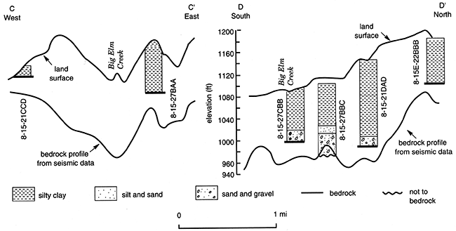
A bedrock low near the town of Mayetta in the center of T. 8 S., R. 15 E., is indicated by a 1978 water-well record from SW NW NW sec. 27, and a 1947 letter about two wells near town. Based on two perpendicular seismic lines (C-C' and D-D', as shown in plate 1 and in fig. 36), the long axis of the buried valley is oriented in a generally north-south direction, and the channel is 0.5 mi (0.8 km) wide. Several Phillips (oil) core logs obtained after the field study are also illustrated in fig. 36. Although the modern drainage complicates evaluation of this buried valley, bedrock-elevation data (in addition to sand and gravel thickness and well yield) suggest that the channel flowed southeastward into the northwest part of T. 8 S., R. 15 E., and then southward from near Mayetta, where it apparently coincides with Big Elm Creek (plate 1). This long, narrow buried valley may have drained ice that covered the northern townships of Jackson County.
Figure 36--Surface topography and bedrock topography as interpreted from seismic profiles for cross sections C-C' and DD'. Location of sections shown in plate 1.
The location and orientation of some of the buried valleys as now mapped may change as new drillers' logs are obtained. Small buried valleys that are masked by modern drainage may also become evident from additional logs that show thick sand and gravel deposits.
Ground Water
Although the bedrock formations in Jackson County generally do not yield significant amounts of water, moderate quantities can be obtained from the Dry and Friedrich shale members of Pennsylvanian age and from the Foraker, Red Eagle, Grenola, and Beattie Limestones of Permian age (Walters, 1953). Water-well records for wells completed in bedrock indicate that the better aquifers yield 5-30 gpm (0.0003-0.002 m3/s), whereas many formations provide less than 1 gpm (0.00006 m3/s) to wells. The quality of water from bedrock units is variable, but the water is commonly highly mineralized.
Figure 37 shows reported yields from wells of various diameters and other construction characteristics in Jackson County. The unconsolidated deposits generally yield a larger quantity of water than the bedrock units. Wells in alluvial aquifers commonly yield 5-25 gpm (0.0003-0.0016 m3/s), and yields from glacial aquifers range up to 600 gpm (0.04 m3/s). The major buried valley in the northeastern part of the county yields the largest quantity of water, but the water quality is variable, as discussed later. The buried tributaries commonly yield 10-50 gpm (0.0006-0.003 m3/s) to wells, but locally yields may exceed 100 gpm (0.006 m3/s).
Figure 37--Estimated well yields, Jackson County.
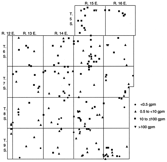
As previously discussed, reported water depths and calculated water elevations are not necessarily representative of a single aquifer and should not be used as an unsorted group to determine ground-water-flow directions. In general, however, the water elevations in Jackson County do appear to decline along the downgradient slope of the major buried valley toward the southeast. The data also tend to support Walters' (1953) conclusion that in the northern area of the county with thick glacial deposits, ground-water movement is generally eastward, with northeastward flow south of Straight Creek (which drains eastward in the northern part of T. 6 S., R. 15 E.) and southeast flow north of the creek.
Caution is again advised in analysis of the water-level data as shown in fig. 38. Nevertheless, the data suggest that the depth to water in Jackson County is generally less than 50 ft (15 m), and in modern stream valleys often less than 15 ft (5 m). Water levels between 50 ft (15 m) and 100 ft (30 m) are not uncommon in some of the thick glacial deposits and the bedrock aquifers. Several wells penetrating bedrock have water levels as deep as 180 ft (55 m).
Figure 38--Depth to water in wells and test wells, Jackson County.
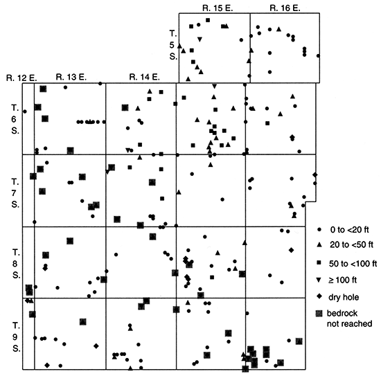
Because the water levels reported for wells may be composites from multiple aquifers or may have other problems, as previously described, saturated thicknesses of unconsolidated deposits (fig. 39) calculated using this data also may be erroneous. As would be expected, however, the greatest thicknesses [ranging up to 200 ft (60 m)] occur over the major buried valley and its tributaries. Modern stream valleys commonly contain 5-40 ft (2-12 m) of saturated deposits.
Figure 39--Saturated thickness of Pleistocene deposits, Jackson County.
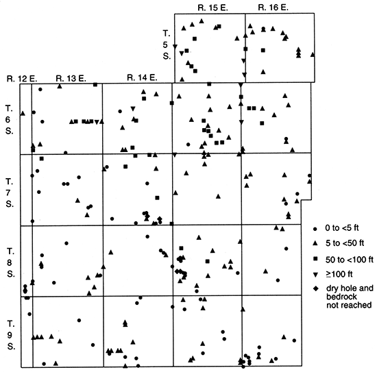
Jefferson County
Geology
The geology of Jefferson County has been mapped and described by Winslow (1972). Rock formations exposed within the county range from the Lawrence Formation (oldest) in the southeast to the Willard Shale (youngest) in the northwest. In outcrops the Douglas Group is represented only by the Lawrence Formation, which consists of 60 ft (18 m) of shale to fine-grained silty sandstone. The Shawnee Group, exposed in the southern, central, and eastern parts of the county, includes 300-400 ft (90-120 m) of shale (several layers of which are carbonaceous), limestone, and local sandstone. Shales, limestones, local sandstones, and two coals compose up to 330 ft (100 m) of the Wabaunsee Group, which is exposed in central and western Jefferson County. These Late Pennsylvanian bedrock units dip generally west-northwestward at 15 ft/mi (2.8 m/km), and they are exposed in ridges, bluffs, and valley walls (fig. 5).
Unconsolidated deposits in the county include glacial drift, lacustrine clay, loess, and alluvium (fig. 9). Except in the uplands of the northeast, they are generally less than 50 ft (15 m) thick (Winslow, 1972). Pre-Illinoian tills range up to 100 ft (30 m) thick; they consist of clay, silt, sand, gravel, and boulders and occur primarily on the uplands. Winslow (1972) thought that a dense, pebble-bearing clay near the bedrock surface in deep test holes in the vicinity of Nortonville was a Nebraskan till. Another till, which he termed Kansan, overlies bedrock or the "Nebraskan (?)" till in the uplands. Near Nortonville this till consists of two or more zones of pebble-bearing clay interbedded with fine- to medium-grained glaciofluvial deposits. Winslow's (1972) geologic map is conservative in its representation of glacial deposits, which are generally more extensive than shown. In the Kansas River area, for example, Davis and Carlson (1952) include better detail of the drift on their geologic map.
In the uplands of north-central Jefferson County the Nortonville Clay covers the glacial deposits. The Nortonville is a silty clay (which locally has a few pebbles and layers of silty sand) and is 0-70 ft (0-21 m) thick (Winslow, 1972). The deposits may have formed in depressions on the till plain (Frye and Leonard, 1952). The designated type location (Thorp and O'Connor, 1966) is 3 mi (5 km) north of Jefferson County (NE NE NW sec. 12, T. 7 S., R. 18 E., in Atchison County).
Loess deposits in Jefferson County occur primarily over bedrock or glacial sediments in the uplands, and they are 0-20 ft (0-6 m) thick (Winslow, 1972). The deposits are thickest in the north and become thin and discontinuous toward the south. The material is predominantly silt with some clay and fine-grained sand. Most of the loess is Wisconsinan, but some is Illinoian (Winslow, 1972; Thorp and Bayne, 1966).
Dissected and weathered terraces of Kansan (pre-Illinoian), Illinoian, and Wisconsinan age occur locally in the Kansas and Delaware River valleys and generally are less than 50 ft (15 m) thick (Winslow, 1972). Davis and Carlson (1952) specifically mapped and described the Menoken ("Kansan") and Buck Creek (Illinoian) terraces along the Kansas River. The Menoken terrace, which is at least 80 ft (24 m) above the floodplain, includes silt, sand, and gravel and minor amounts of glacial till. The Buck Creek terrace is dominated by silt and sandy silt and has local lenses of coarser material (ranging up to fine gravel) in the basal part. The Buck Creek terrace, which is at least 35 ft (11 m) above the the Kansas River floodplain, has generally been removed by erosion except in tributary valleys. It was named for its well-developed surface along Buck Creek in sec. 27, T. 11 S., R. 19 E. A test hole in SWNW sec. 27 penetrated 90 ft (27 m) of silt and clay, and a well in SE SE NE sec. 28 showed bedrock at greater than 97 ft (30 m) deep.
The undissected Newman terrace was also named for its expression in Jefferson County, near the town of Newman. This terrace has been mapped and described by Winslow (1972) and Davis and Carlson (1952). Its surface is commonly 25-30 ft (7.6-9.1 m) above the Kansas River, and the sediments generally include 10-25 ft (3.0-7.6 m) of clay and silt grading downward into sand and gravel.
Kansas River alluvium consists of silt and fine- to medium-grained sand over coarse-grained sand and gravel (Davis and Carlson, 1952), but locally clay fills abandoned meanders. Alluvial deposits in the Delaware River valley are similar (perhaps with clay and silt at the surface), but material in the smaller tributaries is generally finer grained (Winslow, 1972). The total thickness of alluvial and Newman terrace deposits ranges from 0 to 90 ft (27 m), with the largest values in the Kansas River valley.
As can be seen from the geologic map by Davis and Carlson (1952), the floodplain of the Kansas River on the southern side of Jefferson County is generally 2-3 mi (3-5 km) wide. The width is greatest near the mouths of Buck Creek, the Delaware River, and Muddy Creek. The Kansas River itself generally flows along and cuts the southern side of its valley. Davis and Carlson (1952) believed that this results from the Wakarusa River intercepting most of the runoff south of the Kansas River and from the larger and more numerous tributaries to the north of the Kansas River, which provide more sediments and thus produce a delta effect that forces the river to the south. As Davis and Carlson observed, the Kansas River channel shifts north only opposite major north-flowing tributaries (e.g., the Shunganunga Creek at the Shawnee-Jefferson county border). Winslow (1972, p. 3) believed that the present drainage system in Jefferson County "generally has developed along courses coincident with those of a previous drainage system or systems." The Kansas River provides an interesting example. Terraces (e.g., the Menoken and Buck Creek) indicate several earlier episodes of cut and fill. Furthermore, Davis and Carlson (1952, p. 211) state: "North of the Kansas River valley the till-mantled bedrock surface has a slope of about 90 to 100 feet in a distance of from 1 to 2 miles toward the present axis of the valley. The proximity of the glacial margin suggests that this slope was not caused by glacial scour and that a valley existed here prior to Kansan time."
Although undoubtedly modified by glaciofluvial action, the Kansas River and the major northeastern Kansas buried valley (which trends west to east just a few miles north of Jefferson County) probably developed before the advance of ice. Tributaries to these systems in Jefferson County would then have flowed north to the buried valley and south to the Kansas River with a drainage divide between them. As glaciers covered and blocked the rivers, flow directions and paths would have changed. Ice margins also have strongly influenced drainage development, as discussed in other parts of this report.
The bedrock topographic map of Jefferson County (plate 1) was prepared using data from 509 drill holes and measured sections (Denne et al., 1990a) and Winslow's (1972) geologic map with surface topography shown by contours at 50-ft intervals. Where bedrock is at or near the land surface, the surface and bedrock topographic maps are equivalent.
Davis and Carlson (1952) cited evidence [including the position of the former Kansas River at least 15 ft (4.6 m) above the modern floodplain and the thickness of glacial drift to the north] that the topography in the area was more subdued than at present. If true, then the bedrock topographic map (plate 1) reflects this less-dissected surface (especially in the northeast) and not just areas of inadequate data where thick glacial deposits cover bedrock.
There are numerous buried valleys in Jefferson County, many of which are at least partly related to modern drainages. The most striking channel (with definitely nonsubdued topography) occurs in an area that was formerly mapped by Winslow (1972) as bedrock. This narrow buried valley between exposures of bedrock less than 0.5 mi (0.8 km) apart was discovered when a commercial driller put in wells on several 10-acre parcels of land that had been subdivided in connection with the development of Perry Lake (formed in 1970 when the Delaware River was dammed). Although shallow bedrock and low yields were found on most lots, more than 100 ft (30 m) of glaciofluvial sands and gravels were found on one lot (NW NE NE sec. 3, T. 10 S., R. 17 E.). A rural water district subsequently drilled test holes and a well [which was test pumped at 500 gpm (0.0315 m3/s)] close to the private well. Additional test drilling and geophysical investigations in the area (fig. 40) by the Kansas Geological Survey (Denne et al., 1982, 1984) have shown that the channel is locally 500 ft (150 m) wide and up to 200 ft (60 m) deep (figs. 41 and 42) and extends northeast-southwest for at least 1.5 mi (2.4 km) (from SW SW SW sec. 35, T. 9 S., R. 17 E., to SE SE NE sec. 9, T. 10 S., R. 17 E.).
Figure 40--Sites of test drilling and geophysical investigations in the study area by Denne et al. (1982, 1984).
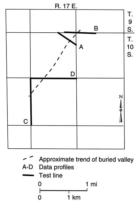
Figure 41--Data profiles A, B, C, and D for Jefferson County test lines. number above profile indicates test site. Highest temperatures measured in August 1980; lower temperatures measured in March 1980.
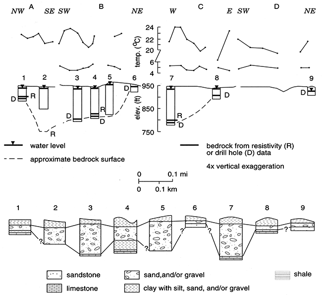
Figure 42--Calculated fill and surface of buried valley.
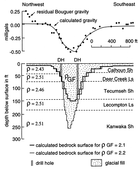
Contouring the short segment of this buried valley into the regional framework is extremely difficult. Not all contours for this buried valley are shown in plate 1 because the channel is extremely narrow and steep-walled. To the north the buried valley probably connects with the modern Delaware River system. It may extend as far as the tributary in NW sec. 25, T. 9 S., R. 17 E. Its peculiar entrance angle to the Delaware River suggests that previously the Delaware may have flowed north or the tributary may have flowed south. If the tributary flowed south, it may have flowed just west of the bedrock high [on which the town of (New) Ozawkie was constructed] toward the wide area of alluvial deposits in central sec. 36, T. 9 S., R. 17 E., and/or to the buried channel.
The observed elevation of the bedrock surface below the buried valley is as low as 783 ft (239 m) (SW NE NE sec. 3, T. 10 S., R. 17 E.), and that value is comparable to the floor of the Delaware and Kansas River valleys as known more than 7 mi (11 km) to the south. A connection to the wide area of Rock Creek alluvium (SW sec. 16, T. 10 S., R. 17 E.) would fit the southwest trend of the buried valley, but information from test drilling in SE SW NE sec. 16 was ambiguous at best. An auger hole at this site indicated sand and gravel from 25 ft to 112 ft (7.6-34.1 m) and a bedrock elevation of less than 833 ft (254 m), but mechanical difficulties make the validity of these data questionable. A rotary hole at this site and within a few feet of the auger hole showed bedrock at a depth of 39 ft (12 m) and an elevation of 906 ft (276 m).
The deep, narrow character of the channel and the coarse-grained material that fills it suggest that the valley was cut and buried quickly by water flowing at a high velocity and/or under a steep gradient, possibly along a preexisting zone of weakness. Field investigations on opposite sides of the buried valley near sec. 3, T. 10 S., R. 17 E., provided no evidence of faulting at the land surface, although a fault could exist at depth. Joints in the bedrock of northeastern Kansas are commonly oriented northeast or northwest (Frank W. Wilson, personal communication, 1986; DuBois, 1978), and the rock layers in Jefferson County strike northeast. Meltwater from an advancing or adjacent glacier could have followed such weak zones. Alternatively, the stream could have developed under high pressure below ice that covered the area.
Other important buried valleys are located in northcentral and northeastern Jefferson County. The channel in T. 7 S., R. 19 E., trends northeastward into Atchison County, where it joins the main buried valley. Several public water supplies (e.g., Nortonville and Jefferson County Rural Water District 12 in secs. 29 and 32, T. 7 S., R. 19 E.) obtain up to 600 gpm (0.04 m3/s) of water from the sand and gravel in the channel. The buried valleys seem to go around a bedrock high in the southwestern comer of T. 7 S., R. 19 E. In this area it also appears that the channels connect southwestward to modern drainages (e.g., Walnut, Brush, and Rock creeks). Perhaps the flow directions changed as the ice advanced and blocked the northern drainageways. Because of limited data and the apparent interrelations of old and modern drainage, the orientations of the buried valleys are difficult to determine.
Upstream from Valley Falls (NE sec. 24, T. 8 S., R. 17 E.), the alluvial deposits of the Delaware River widen from 0.5 mi to 2.5 mi (0.8-4.0 km). The tributary Cedar Creek valley is also wide [0.5-1 mi (0.8-1.6 km)]. In this area the two streams cross the Scranton Shale and the Howard Limestone and locally the Severy Shale and the Topeka Limestone [map units of Winslow (1972)]. Although the bedrock may be at least partly responsible for the increased upstream valley widths, earlier drainage also may have influenced the size and orientation. The Delaware River and Cedar Creek together with either the North Cedar Creek or the South Cedar Creek form a lobate shape that may reflect ice-marginal drainage. Drill holes in NE NE NW sec. 1, T. 8 S., R. 16 E.; NW NE SW sec. 6, T. 8 S., R. 17 E.; SE SW NW sec. 12, T. 8 S., R. 16 E.; and NW SW SE sec. 19, T. 8 S., R. 17 E., show relatively deep bedrock overlain by a thick basal gravel that probably was not deposited by the modern streams. Extensive terraces in the Delaware River and Cedar Creek valleys also represent earlier drainage.
The wide valleys of Peter and Walnut creeks overlie the same bedrock units as do those of the Delaware River and Cedar Creek. Peter Creek valley (west of Valley Falls) also contains a large terrace and enters the Delaware River valley at a peculiar angle (similar to that for the tributary northwest of Ozawkie) for its flow direction. Perhaps Peter Creek formerly flowed south toward Duck Creek, possibly through SW SW SE sec. 3, T. 8 S., R. 17 E., an area mapped as bedrock but where an 80-ft-deep (24-m-deep) well described by Winslow (1972) obtained water from glacial drift. Alternatively, the Delaware River and Peter Creek may have flowed northward to the major buried valley in Atchison County, whereas Walnut Creek and the Delaware River below Valley Falls may have flowed southward to the Kansas River. It is interesting to note that between Valley Falls and Ozawkie, the Delaware River includes several horseshoe meanders. In this region the river cuts the Calhoun Shale and the Deer Creek Limestone, and the bedrock may be largely responsible for the meanders. However, the bends may indicate an older segment of the river or may be a result of a change in discharge, such as would occur if ice blocked the upstream drainage and large amounts of meltwater flowed south.
Several isolated locations in Jefferson County suggest the possibility of additional deep, narrow buried channels similar to the one in T. 10 S., R. 17 E. A drill hole for oil in SW SE SW sec. 16, T. 9 S., R. 17 E. (a low area between two bedrock highs), showed sand and gravel at a depth of 60-70 ft (18-21 m). The channel deposits may connect to the southeast with the modern French Creek or to the west with Rock and Tick creeks (which together form a lobate shape). Another drill hole for oil (NW SE SE sec. 29, T. 8 S., R. 17 E.) had sand from 54 ft to 75 ft (16-23 m); if this material is not sandstone, then it may be a buried channel deposit connected to the Cedar Creek system. A water well in NE SW NE sec. 13, T. 11 S., R. 17 E., indicates a buried valley in an area mapped by Winslow (1972) as bedrock, slightly east of a short [1.5 mi (2.4 km) long], wide [0.25 mi (0.4 km)] modern tributary to the Kansas River. In the southeastern part of the county other seemingly isolated sites (e.g., NE NE sec. 3, NE NE sec. 12, and SE NE SE sec. 18, T. 10 S., R. 19 E.; SE SE NW sec. 19, T. 10 S., R. 20 E.; and NE SE sec. 14, T. 9 S., R. 19 E.) indicate buried drainages that may be at least marginally related to modern streams. In any case, it is difficult to determine whether the general flow direction was northward or southward. In T. 9 S., R. 20 E., numerous drill holes from oil and gas field development near McLouth indicate a north-trending buried valley that appears to underlie the upstream portion of the modern Fall Creek and then cross the divide to follow Prairie Creek. With additional drilling in Jefferson County, many other buried valleys will undoubtedly be located and the orientations of others will become more evident.
The depth to bedrock in Jefferson County (fig. 43) is greatest in two of the buried valleys, where values range up to 179 ft (54.6 m) (SE NW NW sec. 29, T. 7 S., R. 19 E.) in the north-central channel and 175 ft (53.3 m) (SE SE NE sec. 9, T. 10 S., R. 17 E.) in the valley west of Perry Lake. Other great depths to bedrock, several in excess of 100 ft (30 m), occur in the smaller buried valleys (e.g., NE NE sec. 12 and SE NE SE sec. 18, T. 10 S., R. 19 E.; NE NW sec. 8, T. 10 S., R. 20 E.; NW NW sec. 29, T. 9 S., R. 20 E.; and NE SE sec. 14, T. 9 S., R. 19 E.). Typically, however, the glacial deposits throughout the county are between 15 ft (4.6 m) and 65 ft (20 m) thick (which equals the depth to bedrock).
Figure 43--Depth to bedrock, Jefferson County.
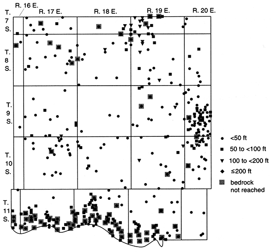
The alluvium that fills many stream valleys in Jefferson County contains glaciofluvial deposits at depth. However, considering both units as one, these deposits range up to 97 ft (30 m) thick (SE SE NE sec. 28, T. 11 S., R. 19 E.). In the Kansas River valley, many drill holes do not reach bedrock, but most of the alluvial deposits (as indicated by 90% of the data points) are between 40 ft (12 m) and 80 ft (24 m) thick. The greatest values [over 80 ft (24 m)] occur near the junctions with Little Muddy Creek, the Delaware River, and Buck Creek. Perhaps these drainages carried the major portion of the glacial meltwater with associated sediments. Deposits in the upper reaches of Buck Creek are as thin as 23 ft (7.0 m), whereas they are as thick as 97 ft (30 m) in the Buck Creek terrace at the junction with the Kansas River Valley. Upstream from the Kansas River, alluvium in the Delaware River valley most commonly ranges from 35 ft to 55 ft (11-17 m) in thickness. Alluvial deposits along other tributaries in Jefferson County are generally between 15 ft (4.6 m) and 50 ft (15 m) thick.
Bedrock is at or near the land surface, especially in western and southern Jefferson County and along the major streams. Locally, thin [generally less than 20 ft (6 m)] colluvium, residuum, or loess deposits overlie shallow bedrock.
The total thickness of sand and gravel in Jefferson County (fig. 44) ranges from 0 to 141 ft (43.0 m). The values are greatest [commonly more than 90 ft (27 m)] in the deep, narrow buried channel west of Perry Lake, where the maximum value occurs in SW NE NE sec. 3, T. 10 S., R. 17 E. The fill of this channel is dominated by coarse-grained sand and gravel. Other significant thicknesses [commonly more than 20 ft (6 m)] of sand and/or gravel occur in the buried-valley system in the north-central part of the county, where at least 73 ft (22 m) of sand was reported in an 87-ft (27-m) drill hole that did not reach bedrock in NW NW NW sec. 27, T. 7 S., R. 19 E., and where 67 ft (20 m) of sand and gravel was encountered in the lower part of a well in SE NW NW sec. 29, T. 7 S., R. 19 E. In a buried channel that appears to trend southward but could instead be connected to the north-central channel, an oil-well log for SE SW NW sec. 34, T. 8 S., R. 19 E., indicates 62 ft (19 m) of sand overlying bedrock at 134 ft (40.8 m). In T. 9 and 10 S., R. 20 E., 5-20-ft (2-6-m) thicknesses of sand and gravel are common in the small buried valleys, although thicknesses range up to 42 ft (13 m) in SW SE sec. 20, T. 9 S., R. 20 E. The buried tributary to the Kansas River in NE SW NE sec. 13, T. 11 S., R. 17 E., has a total thickness of 52 ft (16 m) of sand and gravel with fine-grained sand from 30 ft to 65 ft (9-20 m) deep and a 17-ft (5.2-m) basal sand and gravel layer to a depth of 88 ft (27 m). Other buried valleys, as previously described, typically have 5-25 ft (2-7.6 m) of sand and gravel deposits.
Figure 44--Total Pleistocene sand and gravel thickness, Jefferson County.
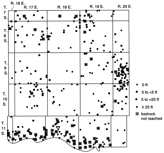
In the Kansas River valley, sand and gravel thicknesses range from 0 to 77 ft (23 m). The smaller values are commonly associated with the Newman and Buck Creek terraces. The larger values [greater than 40 ft (12 m)] occur primarily near the Kansas River junctions with Little Muddy Creek, the Delaware River, Little Wild Horse Creek, and Stone House Creek and along the southern side of the Kansas River valley (especially where tributaries such as Shunganunga Creek enter from the south).
The Delaware River valley contains sand and gravel layers that are 0-57 ft (0-17 m) thick, with the largest values occurring near the Kansas River valley junction. Upstream along the Delaware, the sand and gravel deposits range in thickness up to 25 ft (7.6 m). It appears that the greater sand and gravel thicknesses occur upstream from Valley Falls and downstream from Ozawkie, although this observation may be due to the distribution of data (which is influenced largely by Perry Lake).
Other tributaries in Jefferson County generally have 0-10 ft (0-3 m) of sand and gravel, although larger values occur where recent valleys apparently overlie buried drainages (e.g., in SE SW NW sec. 12, T. 8 S., R. 16 E., and in SW SW SW sec. 35, T. 9 S., R. 19 E.). Values of 10 ft (3 m) can be found in the valleys of Plum Creek, Mud Creek, Buck Creek, and Little Wild Horse Creek. Near the junction of Muddy Creek and the Kansas River valley (SE NE NE sec. 18, T. 11 S., R. 17 E.), 17 ft (5.2 m) of coarse-grained sand and gravel overlie bedrock. These small tributaries must have been close to the ice margin, with its supply of coarse-grained sediments, and/or carried water of large volume or at high velocity.
Ground Water
Bedrock is generally not a good water source in Jefferson County; it commonly yields a few gallons per hour or less (Winslow, 1972). Locally, however, small quantities of water may be obtained from the upper weathered zones (especially of limestones), from sandy layers (e.g., in the Auburn, Scranton, Severy, Calhoun, Tecumseh, or Kanwaka Shales and the Lawrence Formation), or from the Howard Limestone. Many wells inventoried by Winslow (1972) were large-diameter dug wells that obtain water slowly from the weathered bedrock (or glacial till) and provide storage space. Many bedrock wells in the area reportedly obtain brackish water at depths of less than 150 ft (46 m) (Davis and Carlson, 1952).
Estimated yields (uncorrected for well construction and other variables) are shown in fig. 45. The largest values are from the Kansas River valley, where yields of 2,000 gpm (0.1 m3/s) have been reported at the junction with the Delaware River (NE NW SW sec. 16, T. 11 S., R. 18 E.). Values in the range 1,322-1,350 gpm (0.08340-0.08516 m3/s) have been obtained near the junction with Muddy Creek, which is also near the mouth of Shunganunga Creek (e.g., SE SW SW sec. 17, SW NW SE sec. 20, and SE NW NW sec. 20, T. 11 S., R. 17 E.). In these same general areas, eight other wells provide 1,000-1,300 gpm (0.06-0.082 m3/s). In contrast to these large values, more than half (31) of the 59 reported well yields from the Kansas River valley are between only 7 gpm (0.0004 m3/s) and 60 gpm (0.004 m3/s). These wells probably have small diameters, do not penetrate deep enough to reach the basal gravel, and/or are located in an area with only fine-grained material (e.g., abandoned meanders or some terraces). Between the low and high extremes, eight wells had yields between 100 gpm (0.006 m3/s) and 300 gpm (0.02 m3/s) and eight others were between 500 gpm (0.03 m3/s) and 940 gpm (0.059 m3/s).
Figure 45--Estimated well yields, Jefferson County.
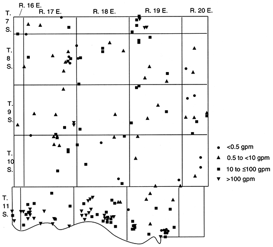
Yields have been reported for 18 wells in the Delaware River Valley. The six largest values [100-300 gpm (0.006-0.02 m3/s)] occur near the junction with the Kansas River valley and near the town of Ozawkie. Ten other wells provide 8-60 gpm (0.0005-0.004 m3/s), with values of 8-40 gpm (0.0005-0.003 m3/s) reported at and above Valley Falls and 15-60 gpm (0.00095-0.004 m3/s) downstream from Ozawkie. Two drill holes in NE NW SW sec. 13, T. 8 S., R. 17 E., and SW SW SW sec. 18, T. 8 S., R. 18 E., were reportedly dry; the first had thin, fine-grained alluvial deposits on an apparent bedrock high, and the second may not have reached bedrock below fine-grained sand at 25-27 ft (7.6-8.2 m). Poor road access and the presence of Perry Lake are not the only reasons for the lack of well yield and other data between Valley Falls and Ozawkie; the narrow alluvial aquifer in this area may not be particularly productive.
Other tributaries in Jefferson County generally yield 0-20 gpm (0-0.001 m3/s). One exception is in SW NW NE sec. 1, T. 10 S., R. 18 E., in Slough Creek, where 50 gpm (0.003 m3/s) is reported for a well with 7 ft (2 m) of basal gravel. The yield and thickness of gravel here tend to support the connection of Slough Creek to the buried channel deposits to the northeast (e.g., in NE NW SW sec. 30, T. 9 S., R. 19 E., and in SE SW NW sec. 34, T. 8 S., R. 19 E.). Well yields of 10-20 gpm (0.0006-0.001 m3/s) are fairly common from several tributaries that drain directly into the Kansas River valley, including Mud, Buck, Little Wild Horse, Prairie, and Muddy creeks. A drill hole in SW NW NW sec. 26, T. 10 S., R. 17 E., suggested a yield of 15 gpm (0.00095 m3/s) from Rock Creek alluvium, and other Delaware River tributaries (e.g., Coal and Cedar creeks) may yield 10 gpm (0.0006 m3/s). Deposits along the smaller streams in the county commonly yield less than 5 gpm (0.0003 m3/s), with some deposits yielding less than I gpm (0.00006 m3/s).
In addition to alluvium, glaciofluvial deposits also provide a significant quantity of water in Jefferson County. The buried valley in the north-central part of the county may yield at least 300-600 gpm (0.02-0.04 m3/s) (e.g., NW SE NE sec. 32, NE SE NE sec. 32, and SE NW NW sec. 29, T. 7 S., R. 19 E.), but more typical values are in the range of 10-60 gpm (0.0006-0.004 m3/s). Although the driller reported an estimated 400-gpm (0.03-m3/s) yield, the rural water district well (SWNENE sec. 3, T. 10 S., R. 17 E.) in the deep, narrow buried valley west of Perry Lake was test pumped at 500 gpm (0.032 m3/s) for 25 hours. The water level in the well declined from 2 ft (0.6 m) to 40 ft (12 m), with stabilization occurring only after 8 hours. Other wells in the area that obtain water from the buried-channel deposits reportedly yield 20-100 gpm (0.001-0.006 m3/s). A well either in the buried valley near McLouth or in sandstone bedrock produces 60 gpm (0.004 m3/s). Other small buried valleys in Jefferson County, as previously described, yield 10-25 gpm (0.0006-0.0016 m3/s). In other areas where glacial deposits are sufficiently thick, especially where they contain sand and gravel lenses, yields of up to several gallons per minute of water can be obtained.
Although most bedrock units provide little [<1 gpm (<0.00006 m3/s)] or no water in Jefferson County, there are several wells that reportedly yield 2-10 gpm (0.0001-0.0006 m3/s) from rock (e.g., in SW NE SW sec. 36, T. 10 S., R. 18 E.; SW SE SE sec. 36, T. 10 S., R. 19 E.; NE SE SE sec. 4, T. 11 S., R. 19 E.; and SW SE NE sec. 23, T. 8 S., R. 17 E.). These wells generally obtain water from "loose" limestone (in drillers' terms), sandstone, and/or shale in the Shawnee Group.
Because of the generally discontinuous character of the water table, the presence of multiple aquifers, the methods of well construction that connect the aquifers, and water-level measurements made at different times by different people, available ground-water-Ievel data are of limited usefulness. Ground-water elevations in Jefferson County suggest that ground-water flow is from the uplands toward the major streams and in the downstream direction in the Delaware and Kansas River Valleys. The average hydraulic gradient along the Kansas River valley in the southern part of the county is 2 ft/mi (0.4 m/km). Locally, depressions in groundwater-level elevations may reflect heavy pumpage. Although it is difficult to determine flow directions in and near the major buried valleys, it appears that water moves from the west toward the narrow, deep channel in T. 10 S., R. 17 E., and from a high area in T. 8 S., R. 19 E., toward the north-central channel in T. 7 S., R. 18 and 19 E., and T. 8 S., R. 18 E.
The depth to water in Jefferson County (fig. 46) ranges from 1 ft to 109 ft (0.3-33.2 m). In the Kansas River valley, 90% of the water-level measurements are between 10 ft (3 m) and 32 ft (9.8 m) in depth. A few other values ranged as shallow as 3 ft (0.9 m) and as high as 47 ft (14 m). In the Delaware River valley, about one-half of the depth to water values are between 10 ft (3 m) and 20 ft (6 m). Several drill holes in thin alluvial deposits near Valley Falls are dry. The maximum depths to water [46 ft and 47 ft (14 m)] are reported upstream from Valley Falls in NE NW NW sec. 13, T. 8 S., R. 17 E. Values as small as 2 ft (0.6 m) have been measured near the junction of the Delaware and Kansas River valleys. In other Jefferson County stream valleys where the alluvium is saturated, ground water is generally between 1 ft (0.3 m) and 25 ft (7.6 m) deep, with all other reported values less than 36 ft (11 m), except for one 68-ft (21-m) value in the Buck Creek terrace (SESENE sec. 28, T. 11 S., R. 19 E).
Figure 46--Depth to water in wells and test wells, Jefferson County.
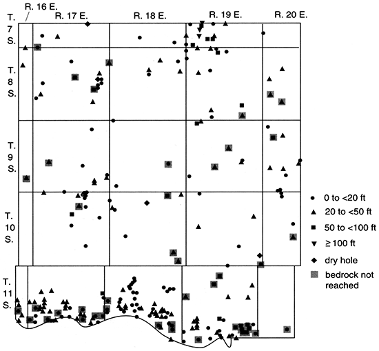
In the glacial deposits, water-level measurements show greater variation. In the north-central buried valley the maximum water-level depth [109 ft (33.2 m)] for the county occurs in SE SE NE sec. 30 and NE NE NE sec. 31, T. 7 S., R. 19 E., whereas the second and fourth largest depths [106 ft (32.3 m) and 86 ft (26 m)] occur nearby in sec. 29. In contrast, the depth to water in test holes in NW NE NW sec. 30, T. 7 S., R. 19 E., and SW SW NW sec. 36, T. 7 S., R. 18 E., is 3 ft (0.9 m). In the deep, narrow buried valley west of Perry Lake, the ground water is shallow, with values typically between 2 ft (0.6 m) and 12 ft (3.7 m). Elsewhere in the county, the depth to water in the glacial deposits is generally less than 50 ft (15 m) and most commonly less than 30 ft (9 m).
The third largest depth to water [95 ft (29 m)] in Jefferson County is from a landfill sampling or monitoring well completed in bedrock (probably the Oread Limestone and Lawrence Formation) in NE NE NW sec. 35, T. 11 S., R. 19 E. Several other sampling wells in the same section had water levels between 60 ft (18 m) and 84 ft (26 m) deep. Each of these wells has a reported yield of 0 gpm, and the reported water level is equal to the total depth of the well. In other areas of the county, bedrock water-level depths range from 10 ft to 78 ft (3-24 m), but most commonly they are less than 31 ft (9.4 m). It should be noted again, however, that many wells drilled into bedrock in the county yield no ground water and are considered dry.
The saturated thickness of unconsolidated deposits in Jefferson County (fig. 47) is greatest in the two major buried valleys [164 ft (50.0 m) in NW NE NW sec. 30, T. 7 S., R. 19 E., and 148 ft (45.1 m) in SW NE NE sec. 3, T. 10 S., R. 17 E.]. Values between 30 ft (9 m) and 80 ft (24 m) are common in the north-central buried-valley system, whereas saturated thicknesses greater than 90 ft (27 m) occur frequently in the deep, narrow channel west of Perry Lake. In the buried valleys near McLouth (especially in T. 9 S., R. 20 E.), saturated unconsolidated deposits range from 15 ft to 45 ft (4.6-14 m) in thickness. In SE NE SE sec. 18, T. 10 S., R. 19 E., the saturated thickness is at least 76 ft (23 m). Elsewhere in the county the saturated thickness of glacial deposits generally is 0-45 ft (0-14 m). More than a dozen drill holes for which the depth to bedrock is up to 30 ft (9 m) have no free water in the unconsolidated sediments. As O'Connor et al. (1979) observed, glacial deposits in the upland areas are often highly dissected by erosion and may be at least partly drained of their water. The larger saturated thicknesses generally occur in buried drainages, some of which underlie recent streams.
Figure 47--Saturated thickness of Pleistocene deposits, Jefferson County.
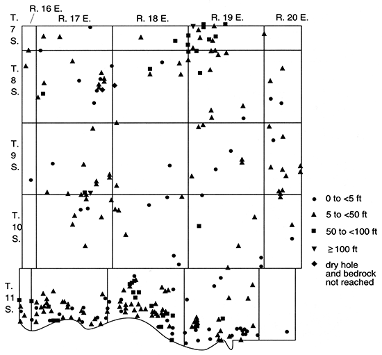
In the Kansas River valley at least 80% of the saturated thickness values for the alluvial deposits are between 25 ft (7.6 m) and 65 ft (20 m). The largest thicknesses [e.g., 50-76 ft (15-23 m)] occur near the junction of the Kansas River with the Delaware River and close to the mouths of Little Muddy Creek and Little Wild Horse Creek. The Buck Creek terrace has up to 74 ft (23 m) of saturated unconsolidated deposits (SW NW sec. 27, T. 11 S., R. 19 E.). In the Delaware River valley, saturated alluvial deposits are 0-64 ft (0-20 m) thick, with the largest thicknesses occurring near the junction with the Kansas River valley. From Ozawkie to 6 mi (10 km) downstream, the saturated thickness is commonly between 15 ft (4.6 m) and 45 ft (14 m). Near Valley Falls several drill holes encountered no saturated unconsolidated deposits that would yield free water, but further upstream values ranged to 37 ft (11 m) (NW NE SW sec. 13, T. 8 S., R. 17 E.). The saturated thickness of alluvial deposits along other streams in Jefferson County is most commonly less than 25 ft (7.6 m). Several larger thicknesses occur along Mud, Rock, and Buck creeks and in areas where modern streams are underlain by buried valleys (e.g., NE NE NW sec. 1 and SE SW NW sec. 12, T. 8 S., R. 16 E.).
In Jefferson County most ground-water discharge is to streams, wells, and evapotranspiration. Recharge is primarily from precipitation, but it may also be from Perry Lake and from the major rivers during floods or induced by pumping. Within the county a large amount of water can be obtained from Perry reservoir and the Kansas River and from the alluvial deposits along modern drainageways and in buried valleys.
Johnson County
Geology
Bedrock is exposed throughout much of Johnson County, and the units include formations of the Kansas City, Lansing, and Douglas Groups of Pennsylvanian age (O'Connor, 1971). Shales, limestones, and some sandstone are included in the total outcrop sequence, which is 500 ft (150 m) thick (fig. 5). The oldest units (the Swope and Dennis Limestones) are exposed in the eastern part of the county, and the youngest unit (the Ireland Sandstone Member of the Lawrence Formation) is in the southwest. The average dip of the rocks is northwestward at 12 ft/mi (2.3 m/km) in this area of the Prairie Plains homocline. Locally the dip is modified by the northeast-trending Gardner anticline, the parallel depression to its east, and several faults, as mapped and described by O'Connor (1971). An upland gravel deposit in NW SE sec. 30, T. 14 S., R. 23 E., consists of quartz, quartzite, chert, and sandstone and was considered a possible remnant of the Dakota Formation (?) (Cretaceous) by O'Connor (1971).
The oldest Quaternary deposits in Johnson County (fig. 9) are pre-Illinoian and include the Atchison Formation (outwash), at least one glacial till, and undifferentiated fluvial and lacustrine deposits. These sediments and their depositional environments have been described by O'Connor (1971), and we give a brief summary in what follows.
A glacial lobe crossed the Kansas River valley and extended southward for 10 mi (16 km) in northeastern Douglas and northwestern Johnson counties. Meltwater from the ice deposited sand and gravel in low areas and on the uplands south of the river [which are 150-200 ft (45-60 m) higher]. Outwash gravel that caps hills in Douglas County has been interpreted to represent deposits made along or in contact with the ice at its maximum southern extent (O'Connor, 1960), and these gravel-capped hills trend northeastward into Johnson County in secs. 26 and 35, T. 13 S., R. 21 E., and sec. 2, T. 14 S., R. 21 E. (O'Connor, 1971). The northwestern part of Johnson County (especially west of Kill Creek) contains much outwash material in addition to sandy till. Some sand deposits may also be from lakes formed when ice blocked the Kansas River and its north-flowing tributaries. The total thickness of these deposits is commonly 30-60 ft (9-18 m) where they have not been removed by erosion.
Second to the northwestern part of Johnson County for extent of pre-Illinoian deposits is the Holliday area in T. 12 S., R. 23 E., as described by O'Connor (1971). Deposits include glacial till, outwash, and sandy silts that may be lacustrine. Buried valleys cross the area, including one that is interpreted to have been cut by an ice-marginal stream that formed when ice blocked the Kansas River valley in secs. 34 and 35, T. 11 S., R. 23 E. An exposure in SE SW sec. 16, T. 12 S., R. 23 E., shows cobble and boulder gravel filling a narrow channel on a hill. In the gravel pit in sec. 11, T. 12 S., R. 23 E., steeply dipping beds of pebble, cobble, and boulder gravel overlie flat layers of sand and gravel, and some zones are cemented with calcium carbonate. A 71-ft (22-m) measured section of sand and gravel from NE sec. 11 at this pit has been described by Newell (1935).
Illinoian deposits in Johnson County include alluvium in the Buck Creek terrace along tributaries of the Kansas River and the Loveland loess (O'Connor, 1971). The Buck Creek terrace is 25 ft (7.6 m) above the younger Newman terrace in the area of sec. 25, T. 12 S., R. 22 E., and includes sand and gravel overlain by locally sandy clay and silt. The silty loess deposits are generally less than 8 ft (2 m) thick and occur on some uplands near the Kansas River and in northeastern Johnson County.
The youngest deposits (Wisconsin and Holocene) also include alluvium and loess and have been described by O'Connor (1971). The Peoria loess is thickest [up to 15 ft (4.6 m)] in the northeastern part of the county, but it is commonly 2-6 ft (0.6-2 m) thick on uplands throughout the area. The Newman terrace occurs in the Kansas River tributaries as deposits of silt and clay overlying sand, gravel, and silt up to 70 ft (21 m) thick. Alluvial deposits in the Kansas River and its tributaries are 3-20 ft (0.9-6 m) below the Newman terrace, and they are generally coarse grained. Very fine grained to medium-grained sand with some thin lenses of silt and clay overlies medium-grained sand to gravel which is above a basal layer of gravel to boulders. The floodplains of the Kansas River and the main tributary streams (of the Kansas, Missouri, and Marais des Cygnes rivers) are 1-2 mi (1.6-3 km) wide and 0.2-0.5 mi (0.3-0.8 km) wide, respectively.
A bedrock topographic map of Johnson County (plate 1) was constructed using data from 401 drill holes (Denne et al., 1990a) and O'Connor's (1971) geologic map (surface topography contours at 50-ft intervals). Because bedrock is exposed in much of the area, the bedrock topography is similar to that of the present surface, with the exceptions of modern stream valleys, the northwestern part of the county, and the area near Holliday.
As previously discussed, buried valleys are evident in exposures in T. 12 S., R. 23 E. The bedrock map and drill-hole data suggest that a now-buried channel to the south of the bedrock knob at the border between T. 11 S., R. 23 E., and T. 12 S., R. 23 E., may have connected the Kansas River valley to the mouth of Mill Creek. In any case, a broad buried drainage is indicated to the north of Clear Creek. The area west of Kill Creek (portions of T. 12-14 S., R. 21 and 22 E.) is part of the Hesper plain area of Douglas County, which has a gentle northward slope to the Kansas River. A test hole in SE SW SW sec. 26, T. 13 S., R. 21 E. (almost directly south of Captain Creek in Douglas County and west of its curve into Johnson County), showed the best buried-channel deposits in this area on the western edge of Johnson County.
There is a severe constriction in the width of the alluvial deposits as mapped (O'Connor, 1971) along Indian Creek in NE sec. 12, T. 13 S., R. 24 E., an area near the beginning of exposures of the Chanute Shale and Drum Limestone. An oil log from 1 mi (1.6 km) upstream (SW NW NE sec. 13, T. 13 S., R. 24 E.) indicates sand and gravel from 44 ft (13 m) to bedrock at 50 ft (15 m), but site investigations do not support the presence of Pleistocene deposits on this slope.
To the east in Missouri, Turkey Creek valley (which heads toward the northeastern part of Johnson County, Kansas) is known to have as much as 242 ft (73.8 m) of Pleistocene (primarily pre-Illinoian outwash) deposits in an abandoned segment (O'Connor and Fowler, 1963). It is believed that the deep channel there formed when ice blocked the extension of the Kansas River (the modern Missouri River) in Missouri and meltwater drained into the Turkey Creek valley, where it eroded the resistant Kansas City Group limestones and shales and the softer underlying Pleasanton Group.
As might be expected for an area near the maximum limit of glaciation, the depth to bedrock in Johnson County (fig. 48) is generally much less than it is to the north. The maximum known depth is 76 ft (23 m), occurring in the Newman terrace at the mouth of Cedar Creek (NW NE SE sec. 26, T. 12 S., R. 22 E.). Three other large values [63-65 ft (19-20 m)] have been found in the Kansas River valley alluvium nearby (NE NW NW, NW NW NW, and SE NW NW sec. 25, T. 12 S., R. 22 E.). The glaciofluvial deposits near Holliday may include the thickest in the county; they exceed 71 ft (22 m) at the exposure (NE sec. 11, T. 12 S., R. 23 E.) previously discussed, and the depth to bedrock in a well in SE SE SW sec. 3, T. 12 S., R. 23 E., is 65 ft (20 m).
Figure 48--Depth to bedrock, Johnson County.
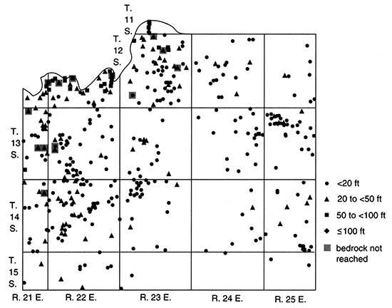
In northwestern Johnson County and in the Holliday area, the depth to bedrock is commonly between 10 ft (3 m) and 50 ft (15 m). Alluvial deposits in the Kansas River valley range from 40 ft to 65 ft (12-20 m) in thickness. In the smaller valleys (tributaries of the Kansas, Missouri, and Marais de Cygnes rivers), the depth to bedrock may be as great as 76 ft (23 m), but it is generally less than 40 ft (12 m). Throughout most of the rest of the county, thin deposits of loess or colluvium overlie bedrock that is near the land surface.
The total thickness of sand and gravel in Johnson County (fig. 49) is greatest in the Kansas River valley alluvium. Values in SW NW SW and SE NE SE sec. 19, NE NW NW sec. 25, NE NE SW sec. 20, and SE SW NW sec. 21, T. 12 S., R. 22 E., range from 50 to 58 ft (15-18 m). The deposits generally include fine-grained sand near the surface and, with the exception of local intermediate layers of clay, become coarser with depth. The sand and gravel layers in the Kansas River valley may only be as thick as 15 ft (4.6 m), but they are more commonly greater than 30 ft (9 m) thick. In the smaller valleys of Johnson County sand and gravel generally make up less than 15 ft (4.6 m) and most frequently less than 8 ft (2 m) of the alluvial deposits. Relatively thick, coarse-grained deposits may be found locally in the Blue River, Cedar Creek, and Mill Creek valleys.
Figure 49--Total Pleistocene sand and gravel thickness, Johnson County.
The sand and gravel layers in pre-Illinoian deposits in northwestern Johnson County generally total less than 15 ft (4.6 m), but the channel in SE SW SW sec. 26, T. 13 S., R. 21 E., contains 45 ft (14 m). On the divide between Kill and Spoon creeks, several oil logs indicate up to 18 ft (5.5 m) of boulders (e.g., SE NE sec. 32, T. 13 S., R. 22 E.); these boulders may represent weathered bedrock, moraine deposits, or narrow boulder-till-filled channels. Near Holliday, sand and gravel make up the entire 71-ft (22-m) measured section (as previously discussed), but the thickest sequence known from a drill hole in that area (NW NW NW sec. 11, T. 12 S., R. 23 E.) is only 25 ft (7.6 m).
Ground Water
The ground-water yields in Johnson County (uncorrected for well diameter and other variables, as previously described) are shown in fig. 50. Yields are largest in the Kansas River valley alluvium; the maximum value reported is 1,200 gpm (0.076 m3/s) in SE NW NW sec. 25, T. 12 S., R. 22 E., near the mouth of Cedar Creek. Other wells in the Kansas River valley generally yield at least 100 gpm (0.006 m3/s), with most exceeding 400 gpm (0.03 m3/s).
Figure 50--Estimated well yields, Johnson County.
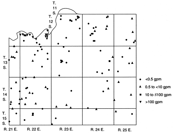
In the tributary valleys yields range up to 100 gpm (0.006 m3/s) (e.g., SW SW SW sec. 1, T. 12 S., R. 23 E., in Mill Creek). Although the data are sparse for other alluvial deposits, O'Connor (1971) reported yields of 25-100 gpm (0.0016-0.006 m3/s) in large tributaries and 1-10 gpm (0.00006-0.0006 m3/s) in small tributaries.
Yields from glaciofluvial deposits in northwestern Johnson County and in the area near Holliday have been reported to be 1-12 gpm (0.00006-0.00076 m3/s). Because many drill holes that provide no yield data indicate large thicknesses of sand and gravel in these areas, yields much greater than 10 gpm (0.0006 m3/s) could be expected locally. For reference, a spring in SW sec. 2, T. 12 S., R. 23 E., was reported to yield 60 gpm (0.004 m3/s) from the lower part of the Quaternary aquifer, even during the 1934 drought (Jewett and Williams, 1935; O'Connor, 1971). In some areas along outcrop margins, little or no water can be obtained because it has been drained. Where the aquifer is dominated by fine-grained sand, yields are also relatively small, and wells must be carefully constructed to avoid pumping fine-grained sand.
Pennsylvanian bedrock units that are exposed in Johnson County commonly yield 0-20 gpm (0-0.001 m3/s), but most are at the low end of the range and many are dry. As described by O'Connor (1971), the major bedrock aquifers include weathered shales or dark shales with vertical fractures of the Hushpuckney, Stark, Muncie Creek, and Eudora Shale Members and the Quivira formation; the Wyandotte Limestone (where it has fractures or solution cavities) and other weathered limestones with open fractures, joints, or bedding planes; and sandstones of the Cherryvale, Chanute, Lane, Bonner Springs, and Vilas Shales, the Lawrence Formation, and the Rock Lake Shale Member of the Stanton Limestone. Except for the permeable areas of the Wyandotte Limestone and the Lawrence Formation, yields from the bedrock units generally range from 0.2 gpm to 5 gpm (0.00001-0.0003 m3/s). At depths greater than 250 ft (76 m), although sometimes less than 100 ft (30 m), water from the bedrock aquifers is saline. The older, deeper rocks commonly yield a large quantity of saltwater.
The saturated thickness of unconsolidated deposits in Johnson County (fig. 51) ranges up to 46 ft (14 m) in NW NW SE sec. 19 and NW NE SE sec. 26, T. 12 S., R. 22 E. These two sites and others with large saturated thicknesses occur in the Kansas River valley alluvium and in the Newman terrace at the mouth of Cedar Creek. Other tributary valleys and the glacial deposits are known to contain 0-20 ft (0-6 m) of saturated material, although the values near Holliday are undoubtedly larger.
Figure 51--Saturated thickness of Pleistocene deposits, Johnson County.
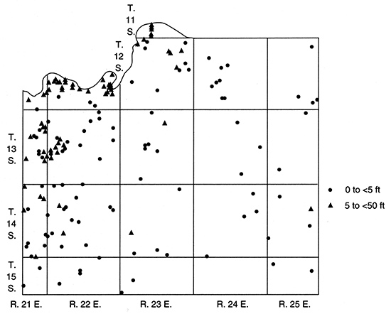
Many drill holes in Johnson County are dry or encounter no free water in the drill hole (fig. 52). Of those that encounter water, the maximum reported depth to water is 125 ft (38.1 m) (SW NW NW sec. 17, T. 15 S., R. 22 E.). Bedrock wells have the greatest depth to water, although they also have some of the smallest [e.g., 8 ft (2 m) in NENE sec. 34, T. 13 S., R. 24 E.]. In the glacial and glaciofluvial deposits, the depth to water is generally between 5 ft (2 m) and 30 ft (9 m). Alluvial deposits in the Kansas River valley and along smaller streams commonly have water within 10-30 ft (3-9 m) of the land surface. However, O'Connor (1971, p. 44) observed that "the water table in the Kansas River valley, at distances more than about 0.5 mile from the river and in areas not affected by industrial, irrigation, or municipal pumping, may fluctuate as much as 15 to 20 feet through a cycle of wet and dry years." Hydrographs for four Kansas River valley observation wells measured from 1961 to 1968 are included in O'Connor's report.
Figure 52--Depth to water in wells and test wells, Johnson County.
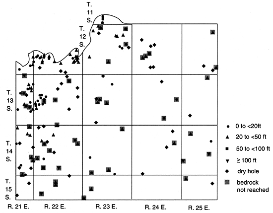
The elevations of ground-water levels in Johnson County decline in the downstream direction in the Kansas River valley. Water-table-contour maps of the valley by Dufford (1958) and Fader (1974) indicate that the average hydraulic gradient is 2.5 ft/mi (0.5 m/km) and that ground water generally flows toward the river. However, heavy pumpage at some localities alters the shape of the contours and sometimes induces flow from the river toward a well.
O'Connor (1971) reported values for some aquifer parameters in Johnson County. Hydraulic conductivity of the Lawrence Formation sandstone ranges from 200 gpd/ft2 to 400 gpd/ft2 (8-16 m/d), whereas for other sandstones it is generally less than 100 gpd/ft2 (4 m/d). Specific capacity for one well in the Ireland Sandstone Member of the Lawrence Formation, which was pumped at 12 gpm (0.00076 m3/s) was 0.8 gpm/ft (0.0002 m2/s). In the coarse-grained glaciofluvial deposits, permeability is probably greater than 1,000 gpd/ft2 (40 m/d). For 12 wells pumped between 150 gpm (0.0095 m3/s) and 1,080 gpm (0.0681 m3/s) in the Kansas River valley, specific capacity ranged from 14 gpm/ft to 116 gpm/ft (0.0029-0.0240 m2/s). Fader (1974) reported the results of aquifer tests for two wells in the Kansas River valley in SW SW SW sec. 24 and SW NW NW sec. 25, T. 12 S., R. 22 E.; the former was pumped at 1,000 gpm (0.06 m3/s) and had a transmissivity of 18,700 ft2/d [139,000 gpd/ft (1,730 m2/d)], and the latter was pumped at 1,080 gpm (0.0681 m3/s) and had a transmissivity of 24,000 ft2/d [180,000 gpd/ft (2200 m2/d)] and a storage coefficient of 0.05.
In Johnson County most discharge is to streams or springs, evapotranspiration, and wells. Most recharge is from precipitation with some by seepage from streams and ponds or by subsurface inflow.
Prev Page--Regional Studies || Next Page--More County Studies
Kansas Geological Survey, Geohydrology
Placed on web March 1, 2015; originally published 1998.
Comments to webadmin@kgs.ku.edu
The URL for this page is http://www.kgs.ku.edu/Publications/Bulletins/229/04_count.html