![]()
Prev Page--Introduction || Next Page--County Studies
Regional Studies
Structural Geology
Northeastern Kansas is located in a structurally stable region of the North American continent characterized by sedimentary rocks of a shallow-marine shelf environment (Merriam, 1963). These sedimentary units are thinly layered with gentle structural features. The Permian and Pennsylvanian beds that crop out in northeastern Kansas have a generally westward dip of 25 ft/mi (4.7 m/km; Merriam, 1963), although the direction of the regional dip varies locally. This outcrop has been called the Prairie Plains homocline, and it originated during post-Permian time as a result of the Ozark area uplift. The Nemaha anticline interrupts and locally reverses the dip of these outcropping strata. The present eastward slope of the land surface formed in late Tertiary time during the deposition of a vast sheet of rock debris over eastern Colorado and western Kansas (Merriam, 1963).
The pre-Mississippian structure in northeastern Kansas is a down warped area north of the Chautauqua arch and east of the ancestral Central Kansas uplift, called the North Kansas basin (fig. 3). The formation of the Nemaha anticline in post-Mississippian time divided the North Kansas basin into the Salina basin and the Forest City basin (Merriam, 1963). The area of northeast Kansas lies mostly in the Forest City basin and includes part of the Nemaha anticline (fig. 3). The Brownville syncline, the axis of the Forest City basin, lies to the east of the axis of the Nemaha anticline and runs parallel to it. This structural proximity gives the Brownville syncline a relatively steep west flank and a gentle east flank (Merriam, 1963).
Figure 3--Structural features of northeastern Kansas; data compiled from Merriam (1963).
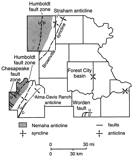
The Nemaha anticline is a buried Precambrian uplift of mostly cataclastically deformed granitic rocks (Bickford et al., 1979). The crest of the Nemaha anticline runs in a north-south direction through Nemaha and Pottawatomie counties and near the western edge of Wabaunsee County (Merriam, 1963). The Precambrian granite along the crest of the uplift lies within 600 ft (180 m) of the surface in Nemaha County but plunges southward so that its depth is 4,000 ft (1,200 m) below the land surface at the Oklahoma border (Zeller, 1968).
The Nemaha anticline is a major structural feature of the midcontinent area. Seismic-reflection data (Steeples, 1981) suggest that uplift along the Nemaha anticline occurred at the same time as Pennsylvanian deposition or uplift and that peneplanation occurred between the deposition of Mississippian and Pennsylvanian sediments. During the Early Pennsylvanian, the granite crest of the anticline was exposed as a low ridge of hills, which shed arkosic sediments into the adjoining basins (Merriam, 1963). Consequently, there are many Paleozoic systems absent along the structure's crest, including the Cambrian, Ordovician, Silurian, and Permian (missing throughout the length of this structure but present elsewhere in Nemaha County) and the Upper Devonian, Mississippian, and Early Pennsylvanian (missing along the Nemaha anticline in Nemaha and Wabaunsee counties) (Zeller, 1968). Pennsylvanian rocks immediately overlie Precambrian rocks along the Nemaha anticline in Nemaha and Wabaunsee counties. The erosional periods at or near the end of the Mississippian and during the Pennsylvanian reduced the Mississippian surface to a peneplain as crests of the anticline were truncated, leaving a greater thickness of Mississippian deposits preserved in synclines (Merriam, 1963). The land surface was deeply weathered during this period, and solution features developed locally (Merriam, 1963).
The basement rock core of the anticline is characterized by a series of knobs along the crest of the structure. Along its eastern side the lower Paleozoic strata have been ruptured, truncated, and overstepped by Pennsylvanian sediments, and the Precambrian rocks that underlie these sediments include a large amount of metamorphic rocks (Merriam, 1963). The generally northwestward dip of the Paleozoic beds is reversed along the eastern side of the Nemaha anticline because of uplift. Permian rocks crop out on both sides of the Nemaha crest in Nemaha County and are also present in the subsurface immediately on the east and west sides of the anticline. The Permian rocks have presumably been eroded from the structure's crest throughout Nemaha County and into the edge of Wabaunsee County.
The Humboldt fault borders the eastern flank of the Nemaha anticline in its northern part, and on the surface its displacement may be up to 100 ft (30 m). The Humboldt fault and its associated faults are known to cut Precambrian and lower Paleozoic rocks discontinuously along the eastern flank of the Nemaha anticline for the entire length of the state (Merriam, 1963).
Steeples (1981) carried out seismic-reflection studies on sections a few miles wide and 2,500-5,000 ft (760-1,500 m) deep. The profiles show that Pennsylvanian sediments are draped rather than faulted over the Nemaha Ridge. Four profiles examined in Nemaha County show one or more faults. One profile shows lower Paleozoic (pre-Pennsylvanian) sediments truncating abruptly against the Nemaha anticline. According to Steeples (1981), the western part of the Forest City basin is characterized by grabens, horsts, monoclines, and normal and possibly reverse faulting, and the case is made for a complex zone of faulting. DuBois (1978) studied the surface lineaments detected on remote-sensing imagery in Nemaha County. Field investigations indicated that faulting occurs at and near the land surface immediately south of the Nebraska border.
Faulting of Permian strata in Nemaha County indicates that post-Permian movement has occurred in the Humboldt fault zone, although the displacement is minor compared with the displacement that occurred between Late Mississippian and Early Pennsylvanian time (Steeples, 1981). The glacial-till deposits of Kansan age were also shown to be faulted (DuBois, 1978). While studying the stream-drainage patterns and surface geomorphic features, DuBois found a strong relationship to the underlying Precambrian basement. Many of the present streams in Nemaha County, especially the Black Vermillion River and Negro Creek, display prominent angular or rectangular drainage patterns. Also, several circular drainage patterns are thought to reflect certain geophysical anomalies (DuBois, 1978). No surficial faulting has been detected south of Nemaha County along the Nemaha Ridge in Kansas (Wilson, 1979).
In Wabaunsee County, the Nemaha anticline is cut by a northwest-trending disturbed zone called the Chesapeake fault zone (Merriam, 1963). This zone can be traced for 600 mi (960 km) through Missouri, Kansas, and Nebraska. The structure is essentially a buried or subsurface graben 6-10 mi (10-16 km) wide with the floor dropped by as much as 1,000 ft (300 m) (Merriam, 1963).
There is a northeast-trending disturbed zone extending for at least 50 mi (80 km) in Douglas County called the Worden fault. This fault is the longest fault recognized on the surface of eastern Kansas (Merriam, 1963), and it developed principally in Early Pennsylvanian time (O'Connor, 1960).
There are many minor structures in northeastern Kansas, and they have been discovered mainly as a result of oil and gas exploration. The Alma-Davis Ranch anticline runs through Wabaunsee County from the southwest to the northeast. The Brownville syncline, which runs parallel to the Nemaha uplift along its eastern side, cuts through Wabaunsee County on the west side of the Alma-Davis Ranch anticline and extends northward to northwestern Brown County (see fig. 3). The McLouth dome is located near the city of McLouth in Jefferson County. The Morris anticline is located in south-central Wyandotte County. The Strahm anticline is in northeast Nemaha County between the east ridge of the Nemaha anticline and west of the Brownville syncline (Merriam, 1963). Located along the crest of the Nemaha anticline are many locally closed anticlinal structures (with local faulting on their steeper eastern flanks), some of which are sizable (Merriam, 1963).
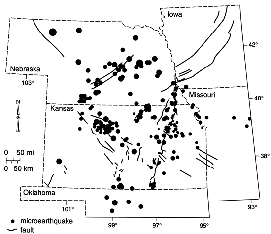
Microearthquakes in northeastern Kansas have been recorded by a network of stations established in eastern Kansas and Nebraska by the Kansas Geological Survey in 1977, and continuously monitored to 1989 (Hildebrand et al., 1988; Steeples et al., 1990), yielding 12 years of record. The pattern of historical earthquakes (last 125 years) reported for the region by Dubois and Wilson (1978) and Steeples et al. (1990) corresponds closely to the pattern of microearthquakes sensed during the monitoring program. Although the Humboldt fault was represented as a singular, long trace on the basement by Cole (1976), Steeples (1982, 1989) has subsequently recognized a zone of faulting tens of kilometers wide along both sides of the Nemaha Ridge after examining the distribution of historical and microearthquake observations and other geological information. The 12-year monitoring program indicated a large number of events on the Nemaha Ridge and low levels of seismic activity bounding it (fig. 4). The diverse pattern of microearthquakes located on the ridge by the seismic network indicates that several faults are sufficiently active to generate small to moderate earthquakes. A myriad of faulting was recognized along the flanks of the Nemaha Ridge via seismic-reflection surveys. Correspondence exists between the gravity and aeromagnetic data and the subsurface faults. Using these data, lineaments detectable on LANDSAT images, and cuttings from hundreds of well cores obtained from both sides of the ridge, Berendsen and Blair (1986) hypothesized faulting between basement crustal blocks. Generally, it is thought that the quakes are the result of reverse faulting in the deep-seated Precambrian rocks (Merriam, 1963). Wilson (1979) speculated that some of the minor seismicity in eastern Kansas and Nebraska may be due to isostatic adjustments resulting from glacial rebound, a hypothesis difficult to prove and unlikely due to the several hundred thousand years (600,000 yrs?) since glaciation. The earthquake risk for the Nemaha Ridge/Humboldt fault zone have been recognized for several years (e.g. Algermissen, 1969; Algermissen and Perkins, 1976).
Figure 4--Microearthquakes along the Nemaha Ridge/Humboldt fault zone recorded by the Kansas Geological Survey between August 1977 and August 1989 (after Steeples et al., 1990). Size-coding is by local magnitude, with largest event at 4.0 and the smallest at 0.8 magnitude.
Pre-Pleistocene Stratigraphy
Northeastern Kansas is characterized by dissected till plains. Glacial sediments of Pleistocene age overlie the older Paleozoic rocks, which are also of sedimentary origin (fig. 5). The Pleistocene deposits are quite thick in some areas, such as Nemaha County (where they range up to 400 ft [120 m] in thickness), but are thin or entirely absent in many other areas. Outcropping rocks of Paleozoic age, including the Pennsylvanian and Permian systems, are present in northeastern Kansas (fig. 6). Where these outcrops are not overlain by glacial drift, they form the Osage cuestas and the Flint Hills physiographic region. Rocks of Mesozoic age are not present in northeastern Kansas.
Figure 5--Geologic map of northeastern Kansas. Adapted from Kansas Geological Survey, Geologic Map of Kansas (Map Series M-1, 1964, scale 1:500,000).
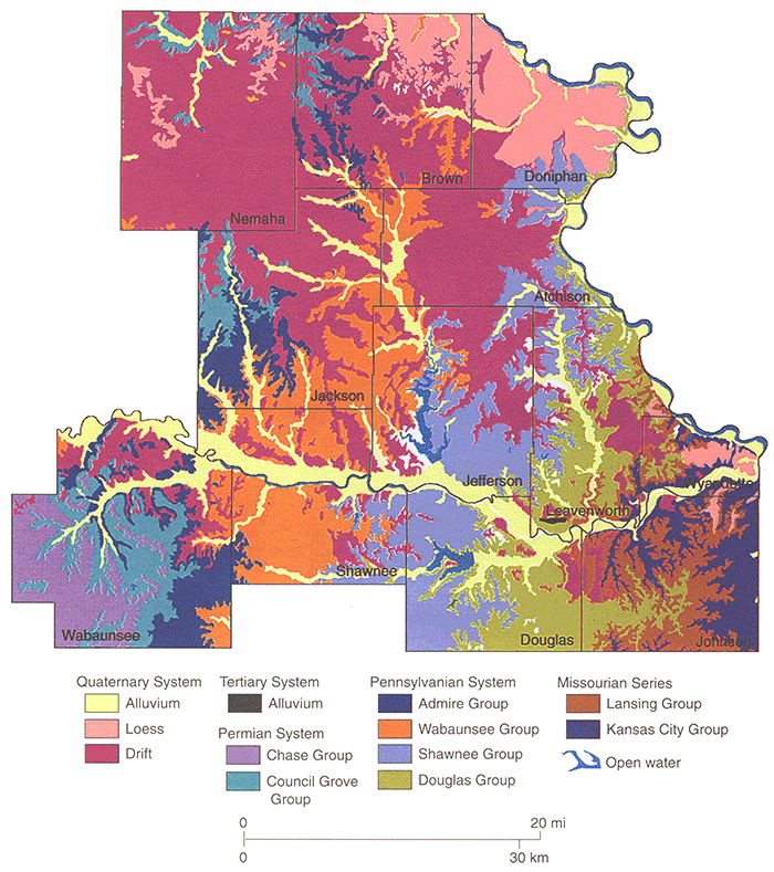
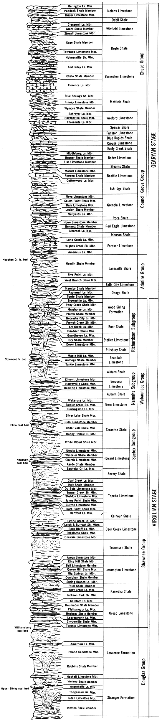
Figure 6--Stratigraphic section of Upper Pennsylvanian (Virgilian Stage) and Lower Permian (Gearyan Stage) Series in northeastern Kansas (Zeller, 1968).
Rocks of Middle and Late Pennsylvanian age are characterized by cycles of sedimentation that correspond to deposits of marine shales and limestones alternating with nonmarine beds of sandstone and coal (Zeller, 1968). Lower and Middle Pennsylvanian rocks (Morrowan, Atokan, and Desmoinesian stages) do not crop out in northeastern Kansas. Missourian Stage rocks crop out in a belt 20-40 mi (30-60 km) wide extending from Wyandotte and Leavenworth counties in the north to Johnson County and part of eastern Douglas County in the south.
The Missourian Stage consists of the Pleasanton, Kansas City, and Lansing Groups. The Pleasanton Group does not crop out in northeastern Kansas but is exposed farther south. The Kansas City Group includes three subgroups and is 325 ft (99 m) thick (Zeller, 1968). The lower unit (Bronson Subgroup) is 175 ft (53 m) thick and contains thick gray limestones that form prominent escarpments and gray, brown, and black shales, brown sandstones, and local coal beds. The middle subgroup (Linn) consists of two limestone and two shale formations. The shales are bluish gray, greenish gray, and dark gray and locally contain much sandstone and thin coal beds. The limestones are generally gray, cherty, and oolitic. The upper part of the Kansas City Group (Zarah Subgroup) is 100 ft (30 m) thick and contains two shale formations and one limestone formation. The rocks are generally dark gray, and the limestone members contain abundant fossils. The Kansas City Group crops out in parts of Johnson, Wyandotte, and Leavenworth counties. The Lansing Group has an average thickness of 85 ft (25 m) and forms escarpments in Wyandotte and Johnson counties and in parts of Douglas and Leavenworth counties. Two limestone formations and one shale formation make up the Lansing Group. The upper limestone formation (Stanton Limestone) is generally gray and fossiliferous and is 25 ft (8 m) thick. It is separated from the lower limestone formation by the shale formation (Vilas Shale), which consists of gray, sandy, silty, carbonaceous shales that are 35 ft (11 m) thick. The lower formation (Plattsburg Limestone) is commonly 30-50 ft (9-15 m) thick in northern Kansas and consists of gray fossiliferous limestones and gray shales that are locally sandy and that contain some sandstones.
Rocks of the Virgilian Stage are 1,200 ft (365 m) thick and comprise most of the Upper Pennsylvanian section cropping out in northeastern Kansas. These rocks are exposed over large areas of Leavenworth, Jefferson, Shawnee, and Douglas counties and are present in parts ofWabaunsee and Johnson counties. Scattered outcrops are present in Doniphan, Jackson, Brown, and Atchison counties where glacial drift covers much of the bedrock. Three groups make up the Virgilian Stage, the Douglas, Shawnee, and Wabaunsee Groups.
The Douglas Group consists mainly of clastic rocks with a few thin limestones and is 240-400 ft (73-120 m) thick. It is divided into two formations, the Lawrence Formation and the Stranger Formation. Coal beds occur locally in both formations along with buff to brown sandstones (Ireland and Tonganoxie Sandstone Members) that are up to 120 ft (37 m) thick where they fill former valleys.
The Shawnee Group is 325 ft (100 m) thick and includes four limestone and three shale formations. The basal limestone formation (Oread Limestone) is 52 ft (16 m) thick and consists of gray, sometimes massive, fossiliferous limestones and black, gray, or yellow shales. One limestone member (Plattsmouth) contains abundant chert. The limestones are less massive in the middle formations but continue to have abundant fossils, as do the shales. Gray sandstones and sandy shales occur locally in the two upper shale formations. The uppermost limestone formation (Topeka) consists of gray, white, and bluish limestones and shales.
The Wabaunsee Group is composed chiefly of shale, is divided into three subgroups, and is 500 ft (150 m) thick. The lower subgroup (Sacfox) contains two shale formations and a limestone formation. The lower shale formation (Severy Shale) is bluish gray and 70-80 ft (20-24 m) thick. The limestone formation (Howard Limestone) is gray, 8--40 ft (2-12 m) thick, and contains sandy portions and a coal bed. The upper shale formation (Scranton Shale) is 125 ft (38 m) thick and consists of gray shale with local sandstone and a thin coal bed. The middle subgroup (Nemaha) contains two limestone and two shale formations and is 150 ft (46 m) thick. The limestones are generally fossiliferous and brown. The shales are generally dark gray or blue and weather gray or light tan; they are usually clayey and contain calcareous layers just below the limestones. The upper subgroup (Richardson) can be distinguished only in northeastern Kansas; it has a thickness of 150 ft (46 m). The Richardson subgroup consists of five formations, mainly shales and limestones with locally occurring channel sandstones. This subgroup is composed predominantly of clayey and sandy blue-gray shale with some red and green shales. The sandy beds are sometimes micaceous, yellow or brown, and loosely cemented. The limestone formations are blue-gray to gray and weather tan or brown; they generally contain one or two members and may weather into platy limestones (Zeller, 1968).
The Lower Permian Series is partly marine and partly nonmarine in origin. It is composed of 1,900 ft (580 m) of evaporite-bearing siltstones, sandstones, and shales and 800 ft (240 m) of alternating limestone and shale with minor amounts of gypsum. The Gearyan Stage, consisting of the Admire, Council Grove, and Chase Groups, forms an exposed belt in Wabaunsee and Jackson counties and along river valleys in Brown and Nemaha counties.
Permian outcrops are present on both sides of the Nemaha anticline in the northeastern corner and along the extreme western border of Nemaha County and include the Admire, Council Grove, and Chase Groups. The lower section of the Permian also crops out in western Brown County and in western Jackson County. Upper Pennsylvanian rocks are also exposed in Jackson, Nemaha, and Brown counties. Wabaunsee County, in the Flint Hills geographic province, has Permian outcrops, including the Council Grove, Chase, and Admire Groups. The Wabaunsee Group of the Pennsylvanian Series is also present along the eastern edge of Wabaunsee County. Shawnee County has some Permian rock exposed on the western edge; otherwise it contains outcrops from the Wabaunsee and Shawnee Groups of Pennsylvanian age. The Wabaunsee, Shawnee, and Douglas Groups are exposed in Jefferson, Atchison, and Doniphan counties. Douglas County outcrops include the Shawnee, Douglas, and Lansing Groups. In Leavenworth County the Shawnee, Douglas, Lansing, and Kansas City Groups are exposed. The Douglas, Lansing, and Kansas City Groups are exposed in Wyandotte and Johnson counties.
The Admire Group consists chiefly of clastic deposits but contains some thin limestone and coal beds. The group's thickness is 130 ft (40 m), with two shale formations and one limestone formation. The shales of the Admire Group are chiefly clayey, but some are silty, calcareous, or sandy. Most of the shales are very thin bedded to almost fissile. They are dark blue-gray and weather light gray or tan. The limestones are generally gray or light brown and weather tan or buff; they are generally massive but weather to thin bedded or platy.
The Council Grove Group is composed of 310-330 ft (94-100 m) of limestones and shales in 14 formations. Limestones in the lower formation (Foraker) are generally gray, massive, and dense. The exception is the Long Creek Limestone Member, which is argillaceous, porous, and thin bedded. It contains many nodules and geodes of celestite and quartz, indicative of subsurface water action (Zeller, 1968). Shales in the lower formations of the Council Grove Group are generally darkgray to green clayey shales and contain lenses of fossiliferous argillaceous limestone. The middle formations are predominantly clayey shales, described as variegated green, red, and tan, and weather to a blocky form. The limestones of the middle and upper formations are generally massive, dense, and tan and form prominent rock terraces.
The Chase Group is made up of 335 ft (102 m) of escarpment-forming limestones alternating with shales. The shale formations are red and green. The thick chert-bearing limestones are a prominent topographic feature of the Flint Hills. Generally, only the lower part of the Chase Group is present in the northeastern Kansas outcrops, except in Wabaunsee County, where it is well represented.
The Cambrian through Permian systems are represented in the subsurface of northeastern Kansas, although many series are absent or not well developed and much geologic time is not represented. Generally, the series not represented in northeastern Kansas include Lower and Middle Cambrian, Upper Silurian, Upper Permian, Lower and Middle Triassic, and Lower and Middle Jurassic. The Paleocene, Oligocene, and Eocene series are not present in the Tertiary System deposits in northeastern Kansas (Merriam, 1963). These missing series are shown in the stratigraphic section as unconformities.
The major unconformities in the Paleozoic section are between the Mesozoic and Paleozoic erathems, the Pennsylvanian and Mississippian systems, the Devonian and Silurian systems, and the Paleozoic and Precambrian erathems. There are disconformities, marked by channel sandstones, in the Permian and Pennsylvanian deposits. The end of the Paleozoic is marked by a complete change in depositional and structural conditions, generally characterized by nonmarine sediments and erosional geologic processes (Merriam, 1963).
The sedimentary rocks of the Paleozoic erathem are underlain by Precambrian basement rocks, which form the stable interior of the United States and are an extension of the Canadian Shield. The shallowest known Precambrian rocks encountered in Kansas test wells are in Nemaha County, where the surface of the Precambrian rises to 588 ft (179 m) above sea level and 580 ft (177 m) below land surface. The greatest penetration of Precambrian rocks is 2,551 ft (777.5 m) in a test hole drilled in Nemaha County. In contrast, the deepest occurrence of Precambrian rocks in Kansas is at least 4,595 ft (1,401 m) below sea level in the Hugoton embayment in southwestern Kansas. The main Precambrian rock types in northeastern Kansas are granite and granite gneiss.
Tertiary deposits in northeastern Kansas are generally recognized as chert gravels derived from the Flint Hills region. The most easily recognized sections are accumulations of chert gravel in a brownish-red clay matrix; they are less than 20 ft (6 m) thick. The deposits occur as dissected terrace deposits at elevations 100-200 ft (30-60 m) higher than the present major streams (Zeller, 1968). The exact age of these deposits has been debated by many investigators, who report deposition during the Nebraskan Stage or during the late Pliocene (Mudge and Burton, 1959). In any case, because of the absence of glacial erratics in the gravel deposits, these deposits are preglacial. Thick deposits occur in Wabaunsee County along major streams and along the upper terraces of the Kansas River (Mudge and Burton, 1959).
Quaternary Stratigraphy
Classical Pre-Illinoian Glacial Geology of Northeastern Kansas
Quaternary sediments blanket Permian and Pennsylvanian bedrock throughout much of northeastern Kansas. The thickness of the these deposits varies widely from 0 in areas where these sediments were eroded or deposition did not occur to 400 ft (120 m) in areas where deposits fill pre-Pleistocene bedrock valleys. The Pleistocene geology of Kansas has classically been divided into eight stages in the time-stratigraphic classification [see table 3, Zeller (1968)]. Four major glaciations were recognized and are represented by the Nebraskan, Kansan, Illinoian, and Wisconsinan stages. Glaciers of the Nebraskan and Kansas stages were presumed to be the glaciers which actually reached northeastern Kansas. Three associated interglacial stages, the Aftonian, Yarmouthian, and Sangamonian, were characterized by warmer climates and stable land surfaces on which regionally extensive, isochronous soils, or geosols (North American Commission on Stratigraphic Nomenclature), formed (Frye and Leonard, 1952; Zeller, 1968).
Glaciation in northeastern Kansas has received a large amount of attention during the last 85 years. Several aspects of glaciation in Kansas were first studied by Chamberlin (1886, 1895) and Todd (1909, 1911, 1923). Detailed mapping of the glacial limit in Kansas has been conducted by several investigators, including Todd (1918b), Schoewe (1941), Jewett (1964), Dort (1985, 1987a), and Aber (l988a). Frye and Leonard (1952) were the first to conduct detailed studies, in a systematic fashion, of the glacial stratigraphy in the state. They identified two tills, an upper one (Kansas till) and a lower one (Nebraska till), which are frequently separated by a sandy glaciofluvial or lacustrine deposit called the Atchison Formation. Notably, these investigators used the term "Nebraska," although it could not be correlated with the type till. Hallberg (1986) and Aber (1991) observed that by the 1950's glacial stratigraphy of Kansas had evolved to the point that the type area for Kansan glaciation, northeastern Kansas, had a stratigraphy defined from accepted stratigraphy for Iowa and Nebraska, without a viable basis for correlation. The importation to Kansas of such lithostratigraphic terms from Iowa and Nebraska was subsequently criticized by Jewett (1963), however. Another difficulty arose from the indiscriminant use of the Pearlette volcanic ash as a regional stratigraphic marker throughout Kansas and Nebraska (e.g., Read, 1948; Frye and Leonard, 1952), despite the fact that mineralogical differences among the ashes had been documented (Swineford and Frye, 1946).
Given the obvious stratigraphic difficulties, a glacial stratigraphy for the state developed within the context of the classical glacial chronology (table 1). The Nebraskan Stage was the first major cycle of Pleistocene glaciation, and deposits are generally restricted to the northeastern corner of Doniphan, Atchison, and Brown counties in Kansas. Large exposures that include the David City Formation (Lugn, 1935), water-laid proglacial deposits, and the Iowa Point till (Reed and Dreeszen, 1965) are present along the Missouri River bluffs in Doniphan County. The Iowa Point section (NE SE sec. 6, T. 2 S., R. 20 E.), located along the bluffs, is the type section for the Iowa Point till. The David City Formation, first described from well records near David City, Nebraska (Frye and Leonard, 1952), is also present in the Iowa Point section, where it rests on Pennsylvanian limestone. It is composed of beds of gravel and cobbles and sand and silt in which laminations and crossbedding are evident. Fossil shells, including small clams and aquatic snails, have been found in sand lenses. Localized calcium carbonate cementation has occurred, rendering the entire unit calcareous.
Table 1--Stratigraphic units of the Pleistocene and Holocene Series, northeastern Kansas.
| Series | Stage | Rock Unit | Thickness (ft) |
Physical Characteristics | Distribution |
|---|---|---|---|---|---|
| Holocene | fluvial deposits, minor terraces |
60 (avg.) | silt, sand, and gravel composed of limestone, chert, and igneous and metamorphic fragments |
all major valleys and many minor valleys |
|
| Bignell Formation | 10 (avg.) | eolian silt | on uplands and terraces, especially thick along Missouri River bluffs |
||
| Pleistocene | 1. Wisconsinan | Fluvial deposits | 0-50 | clay, silt, sand, and gravel derived in part from glacial material |
underlies low terraces in major river valleys |
| Brady Soil | 14 (max.) | geosol; leached gray silt grading downward into a more compact faint reddish-buff silt |
recognized along Missouri River bluffs |
||
| Peoria Formation | 30 (avg.) | eolian silt, buff, massive, generally fossiliferous and calcareous, coarse- to fine-grained |
generally on uplands and terraces |
||
| Gilman Canyon Formation |
2-4 | eolian (silt) and alluvial facies; lower part is light-gray to nearly white silty clay; upper part is dark- gray silty clay; dominated by a well developed geosol |
between the Sangamon soil and Peoria loess; with alluvium and low terraces |
||
| fluvial deposits | 0-50 | silt, sand, and gravel | not exposed; overlain by deposits of late Wisconsinan and Holocene ages |
||
| 2. Sangamonian | Sangamon Soil | 24 (max.) | A horizon is dark-gray to grayish brown; B horizon is reddish-brown with some caliche |
especially thick along the Missouri River valley; becomes thin and discontinuous westward |
|
| 3. Illinoian | Loveland loess | 15 (avg.) | reddish-brown or yellowish- brown eolian silt (loess) |
especially thick along the Missouri River valley; thin and discontinuous elsewhere |
|
| 4. Yarmouthian | Yarmouth soil | 10 (avg.) | eroded remnants of a paleosol composed of deeply oxidized till with caliche at the base |
||
| volcanic ash (pearlette O?); loess, glaciofluvial, and lacustrine deposits |
20-60 | clay, silt, sand, and gravel; locally contains the ash bed and Nortonville Clay |
adjacent to major stream valleys; Nortonville Clay present at top of Cedar Bluffs Till in upland areas of Atchison and Jefferson counties |
||
| 5. Kansan | Nortonville Clay; Cedar Bluffs Till |
0-100 | heterogeneous mixture of brown to reddish-brown clay, yellowish- brown or light-gray clay, silt, sand, and gravel; erratics are common; local lenses of sand and gravel |
blankets northeastern Kansas |
|
| glaciofluvial deposits |
0-50 | outwash materials (silt, sand, gravel, and boulders) |
|||
| Nickerson Till | 0-40 | heterogeneous mixture of dark- gray to bluish-gray clay with some reddish-brown clay, silt, sand, and gravel. Contains fewer erratics than Cedar Bluffs Till; locally contains lenses of sand and gravel |
present in thick till deposits in northeastern Kansas |
||
| Atchison Formation |
0-100 | well-graded, finely crossbedded, fine-grained to very fine grained silty sand; thin layers of clay and gravel scattered throughout; gravel common at base |
generally confined to buried valleys |
||
| 6. Aftonian | Afton soil | 0-15 | dark-gray in till or fluvial deposits in poorly drained areas and red in loess in well-drained areas |
||
| 7. Nebraskan | loess and glacio- fluvial deposits |
0-10 | water-deposited silt and clay | ||
| Iowa Point till | 0-30 | unsorted clay, silt, sand, gravel cobbles, and boulders |
present in extreme northeastern Kansas (Doniphan and perhaps Atchison counties) |
||
| David City Formation |
0-15 | upper part, gray and brown clay, and limestone gravel containing some arkosic material |
Atchison, Brown, and Doniphan counties |
||
| Compiled from Zeller (1968), Frye and Leonard (1952), and Johnson (1993). | |||||
Presence of the Nebraskan till (Iowa Point) in parts of Doniphan, Atchison, and Brown counties, and perhaps along part of the Kansas River in southwestern Leavenworth County (Schoewe, 1930b), represents the earliest glacial deposits in Kansas. The Iowa Point Till consists of a clay-sand-silt matrix with boulders and cobbles and exhibits lenses and zones of well-sorted sand. The boulders and cobbles are predominantly limestone, but commonly consist of pink quartzite, conglomeratic quartzite, igneous rocks, and metamorphic rocks. The upper part of the till is darkened by organic matter (Afton Soil) and is leached of carbonates to 2.5 ft (0.8 m) where the soil is present; the lower part of the till is gray-tan.
The Aftonian Stage represents a weathering period, as demonstrated by the absence of limestone and granitic pebbles and by the presence of resistent quartzite pebbles. The Aftonian is represented by a Humic Gley soil and is sometimes referred to as a gumbotil (Frye and Leonard, 1952). The Afton Soil is well-developed and recognized in Nebraska and Iowa, where it overlies the Iowa Point Till. It tends to be dark gray to black and developed on a poorly drained surface (Reed and Dreeszen, 1965), thereby being classified as an Aquoll (Soil Survey Staff, 1992), or Weisenboden in the old soil taxonomy.
Kansan Stage deposits include the Atchison Formation (Frye and Leonard, 1952), Nickerson Till (Reed and Dreeszen, 1965), and the Cedar Bluffs Till (Reed and Dreeszen, 1965), interrupted by deposits of loess, glaciofluvial sediments, and lacustrine deposits. The Nickerson and Cedar Bluff Tills have been commonly referred to jointly as the Kansas Till. Overall, the volume of Kansan deposits exceeds that of any other Pleistocene stage deposits in northeastern Kansas.
The Atchison Formation is a pro- Kansan outwash of early Kansan age with a maximum thickness of 100 ft (30 m). The type section, located along a creek bank exposure in Atchison County (SE SW sec. 2, T. 6 S., R. 20 E.), is 70 ft (20 m) thick (Frye and Leonard, 1952). The upper part consists of silt and fine-grained sand (sometimes called "quicksand"), while the basal section is made up of coarser sand and gravel, which occur locally. Similar deposits occur locally between the Cedar Bluffs and Nickerson Tills. The Atchison Formation may have originated as outwash and lacustrine deposits in proglacial lakes produced by the advancing Kansan glacier (Frye and Leonard, 1952). The major buried-valley system, extending across southern Nemaha County and through Atchison County, contains large thicknesses of these deposits. Test drilling has shown that the Kansas till is composed of 50-60 ft (15- 18 m) of oxidized till in the upper part, which grades downward into blue-gray unoxidized calcareous till. Color has been explained by the varying degrees of weathering and leaching of the originally deposited till. Three intergradational zones have been described by Frye and Leonard (1952). Frye and Walters (1950) reported well-developed joint systems in some till exposures; the joints may have oxidized rinds or calcium carbonate accumulations along joint planes.
Most till layers are less than 40 ft (12 m) thick and consist of brown or yellowish- to reddish-brown clay. Some lenses of sand and gravel are present locally. Both till units are, however, distinct and differ appreciably from one another. The Nickerson Till, as the most extensive till sheet in Kansas, occurs mainly north of the Kansas River and east of the Little Blue River, with the thickest accumulations in Nemaha, Jackson, and Atchison counties. It is predominantly a dark-gray or blue-gray calcareous till containing local lenses of sand and gravel. The till is mostly unstratified and unsorted and includes sediments that were probably deposited directly from glacial ice, i.e., ice-contact deposits (Frye and Leonard, 1952). Boulders and weakly developed soil zones are present locally. In contrast, the Cedar Bluffs Till is generally more deeply weathered and contains more erratics than the Nickerson Till.
A light-gray massive, plastic clay layer named the Nortonville Clay occurs locally above the Cedar Bluffs Till on upland areas of southwestern Atchison, northern Shawnee, Jefferson, and Jackson counties (Frye and Leonard, 1952). This layer was believed to result from lacustrine deposition in depressions on the newly formed Kansas Till plain. Where present, the Nortonville Clay generally rests upon oxidized and calcareous till with nodules of caliche and is overlain by a few feet of leached Peoria loess. The thickness of the Nortonville clay can reach 40 ft (12 m).
Glaciofluvial sediments deposited as the Kansan glacier(s) retreated were formerly called the Meade formation in northeastern Kansas. Deposits rest above the Cedar Bluffs Till adjacent to major stream valleys. Along the Kansas River these deposits are identified as fill beneath the Menoken terrace (Davis, 1951), and they lie 80 ft (24 m) above the present floodplain (Frye and Leonard, 1952). A few exposures occur in Nemaha County in road cuts and a gravel pit (NW sec. 31, T. 2 S., R. 13 E.). Some glaciofluvial deposits interfinger with underlying till, confirming the relative age of these deposits. Few exposures of glaciofluvial sediments are present in areas thickly mantled by Kansas Till. Deposits dated through their association with a volcanic ash identified as Pearlette by Frye and Leonard (1952) generally rest uncomformably on Kansas Till in Nemaha County.
Recent Changes in the Pre-Illinoian Glacial Stratigraphy
The recognition of several tills indicated that more than two glacial advances into Kansas and Nebraska had occurred, leading many investigators to conclude that the Kansan glaciation was more complex than earlier thought (e.g., Reed and Dreeszen, 1965; Dort, 1966; Bayne, 1968; Boellstorff, 1978). Dort (1969, 1972a), upon examining Pleistocene sections in Doniphan County, suggested that perhaps six or seven separate ice advances were recorded. Dort (1969) also suggested that there might be more than four Pleistocene glacial episodes affecting Kansas, possibly including a pre-Nebraskan glaciation. Bayne et al. (1971) found evidence to support two Kansan tills separated by an interstadial paleosol and proposed dividing the Nebraskan Stage into two substages on the basis of a pre-Aftonian paleosol. Reed and Dreeszen (1965) revised the classification of the Pleistocene deposits in Nebraska because of evidence of multiple glacial pulsations within the Kansan and Nebraskan stages. Consequently, the two-stage model of regional glaciation was modified to accommodate the increased complexity recognized in the glacial stratigraphy (Frye, 1973).
Widespread use of the Pearlette ash bed as a marker bed separating the Yarmouth ian and Kansan stages and as an indicator of deposits of late Kansan age was brought into question by the work of Naeser et al. (1973) and Boellstorff (1976, 1977). Research involving the dating of volcanic ashes has shown that the Pearlette ash actually comprised three separate ashes having multiple names: ages include 2.01 ma (Pearlette B, Huckleberry Ridge, Borchers), 1.27 ma (Pearlette S, Coleridge, Mesa Falls), and 610 ka (Pearlette O, Pearlette Restricted, Lava Creek B, Cudahy, Hartford). As a result, Boellstorff (1977) advocated discontinuance of the classic stage terms "Nebraskan," "Aftonian," and "Kansan" and recommended the redefinition of some tills and nonglacial units.
It has become apparent, particularly in recent years, that northeast Kansas was glaciated by two major advances (Schoewe, 1931; Dellwig and Baldwin, 1965; Aber, 1985, 1988a). However, some debate has occurred over the proposed two-ice-lobe model for Kansan glaciation (Aber, 1982, 1985). Aber developed a model that incorporates two confluent ice streams, the Dakota and the Minnesota ice. This model was based on evidence of a resistant topographic barrier, striations, ice-push structures, distribution of Sioux quartzite erratics, and lithologic differences in till layers. Conversely, Dort (1965) believed that the lithologic differences in the till layers are due to climatic influences that caused local ice formation at the glacial front, which contained locally derived sediment only. At a later time, ice that carried cystalline rock debris from distant northern sources arrived.
Aber (1985, 1988b) and Aber and Wayne (1986) proposed redefining Kansan and Nebraskan stratigraphy and the stratotype for the Kansas drift plains west of Atchison, e.g. "At the proposed stratotype, the Kansas drift contains three formations: Lower Kansas Till, Atchison Formation, and Upper Kansas Till. The Lower Kansas Till was deposited by the Minnesota ice lobe coming from the northeast, whereas the Upper Kansas till was laid down by the Dakota ice lobe advancing from the northwest" (Aber, 1985, p. 53). Aber and Wayne thought that the Upper Kansas Till could be the Nickerson Till and that the Lower Kansas Till was equivalent to the Fremont till in Nebraska. In their classification, the Nebraskan was considered the first substage of the Kansan or was deleted and older tills, such as the Geary School till were assigned to the upper Pliocene.
Given the failure of attempts to accommodate the complexity of the glacial stratigraphy within the classic pre-Illinoian stage terminology, it has become apparent that the terms "Nebraskan" and "Kansan" should be abandoned in Kansas (Dort, 1985, 1987a; Aber, 1991), as has been done elsewhere in the midcontinent (Hallberg et al., 1980; Hallberg, 1986; Richmond and Fullerton, 1986). Data from test holes assembled for this study certainly document the complexity of the glacial deposits and difficulties involved in tracing specific deposits over a wide area.
The most recent and comprehensive research into the glacial history of northeastern Kansas is that by Aber (1988a; 1991), in which he recognizes two tills and adopts the term diamicton (a non-generic term referring to poorly sorted deposits such as till) to decribe them. The lower diamicton had been designated as the Nebraska, Iowa Point, Nickerson, or lower Kansas Till, whereas the upper diamicton has been known as Kansas, upper Kansas, or Cedar Bluffs Till. Weathering zones, paleosols, or stratified sediments separate the two diamictons. Although others observed additional diamictons and associated paleosols (e.g., Bayne et al., 1971; Bayne, 1968; Dort, 1985), Aber (1991) believed the number of diamictons is reducible to two and that, with the abandonment of pre-Illinoian terminology, a new nomenclature should be introduced. To this end, Aber (1991) introduced the Independence Formation to include all diamicton and stratified sediments in northeastern Kansas. He does not formally subdivide it into members but does divide it into upper and lower diamictons on the basis of the exposure at his designated holostratotype near West Atchison, Atchison County (Aber, 1988b).
According to Aber (1991), two distinct glacial advances are represented by the two diarnictons. The lower diamicton and overlying stratified sediments are associated primarily with the large buried valley of the study area, and the upper diamicton mantles the surface on the uplands as well as above the buried valleys. On the basis of directional indicators, the lower diamicton advanced from the northeast as the Minnesota lobe, extending into northern Leavenworth, Jefferson, and Jackson counties, and covered most of Nemaha County (fig. 7) to form the early Independence glacial limit. The upper diamicton was subsequently deposited from the northwest as the Dakota lobe advanced into Kansas, covering a greater areal extent and reaching south of the Kansas River valley and west of the Little Blue River valley. Aber (1991) proposed that the maximum limit of glaciation was determined by five regional bedrock escarpments: the Fort Riley Limestone Member--southwestern Marshall County, Flint Hills escarpment--north-central Wabaunsee County, Bern Lirnestone--southwest of Topeka, Oread Limestone--southwest of Lawrence, and Lansing-Kansas City Groups--northern Johnson County. Aber (1991) also speculated that the Independence Formation correlates with the type A2 and A3 tills recognized in the Nebraska and Iowa region (Hallberg, 1986) and with the McCredie Formation of north-central Missouri (Guccione, 1983).
Figure 7--Preglacial valley and glacial limit (after Aber, 1991).
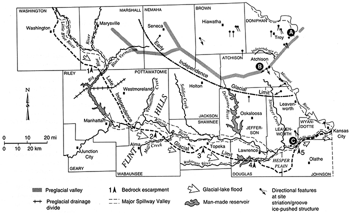
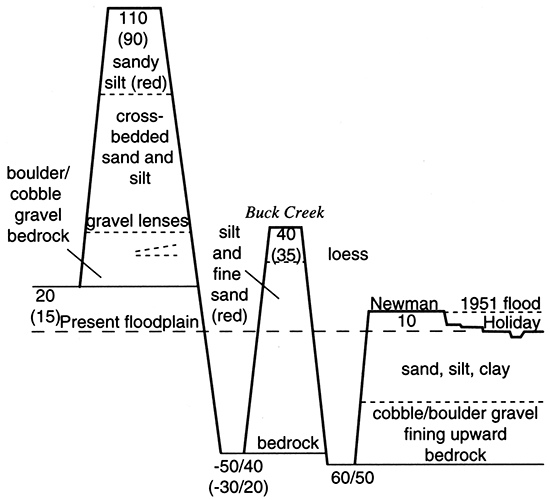
Northeastern Kansas likely experienced numerous drainage blockages and diversions during the course of glaciation. The west-to-east flowing preglacial drainage ways (fig. 2; plate 1) was blocked by the pre-Illinoian glacial advances into Kansas (Early and Late Independence advances), and several ice-marginal drainage systems developed, e.g., the Blue, Kansas, and Wakarusa (Todd, 1911; Aber, 1989). Blockage of this large preglacial system created a large lake, glacial Lake Atchison. Two or more large overflow outlets were identified by Aber (1991), and once established, this spillway system experienced runoff and meltwater discharge from the entire northern Great Plains (Dort, 1987a). Periodic damming also occurred along the ice front, creating pro glacial lakes, as evidenced by the existence of glaciolacustrine deposits in the Kansas River valley. Dort (1987a) hypothesized the existence of two such lakes in the Topeka and Manhattan areas, but these lakes and their releases were probably ephemeral and therefore difficult to document and date (Aber, 1991). Although the temporal relationship to the lakes is unclear, outwash accumulated in the Kansas River valley to form fill of the Menoken terrace (Davis and Carlson, 1952), situated about 110ft (34 m) above the modern floodplain (fig. 8; Dort, 1987b).
Figure 8--Menoken terrace (Dort, 1987b).
Age of the Independence Formation has been determined by Aber et al. (1988) and Aber (1991) using fission-track dating of volcanic ash, biostratigraphy, and paleomagnetic data. Volcanic ash exposed within alluvium of the Kansas River valley near De Soto, dated to 620 ka (Geil, 1987), provides a minimum age of the Independence Formation: the alluvium is probably postglacial because catastrophic flooding likely removed pre-existing alluvium in such a setting. The Wathena local fauna (Einsohn, 1971) from the Independence Formation parastratotype south of Wathena in Doniphan County (Aber, 1991) is similar to faunas elsewhere in the Great Plains that date to approximately 1.0 ma (Martin and Schultz, 1985), thereby lending a maximum age to the formation. Paleomagnetic data from the lower diamicton indicated no reversals in polarity (Abdelsaheb, 1988), probably placing the event in the early Brunhes chron ~0.7-0.6 ma (Aber et al., 1988). An age of 0.7-0.6 ma for the glacial event corresponds with marine oxygen-isotope stages 18-16 (Shackleton and Opdyke, 1973, 1976), which agrees well with data presented in Richmond and Fullerton (1986) and Ruddiman and Wright (1987).
Illinoian and Post-Illinoian Stratigraphy
Deposits of this period in northeastern Kansas reflect the indirect influence of the glacial environment, rather than the direct influence of glacial ice. Consequently, the deposits are primarily of eolian and alluvial origins, and relatively well-preserved when compared with the older glacial deposits (fig. 9). Stratigraphy for this part of the Pleistocene and for the Holocene is relatively well understood and has been refined in recent years (e.g., Johnson, 1987, 1993). Table 1 reflects changes since the last formal statement of stratigraphic succession in Kansas by Zeller (1968).
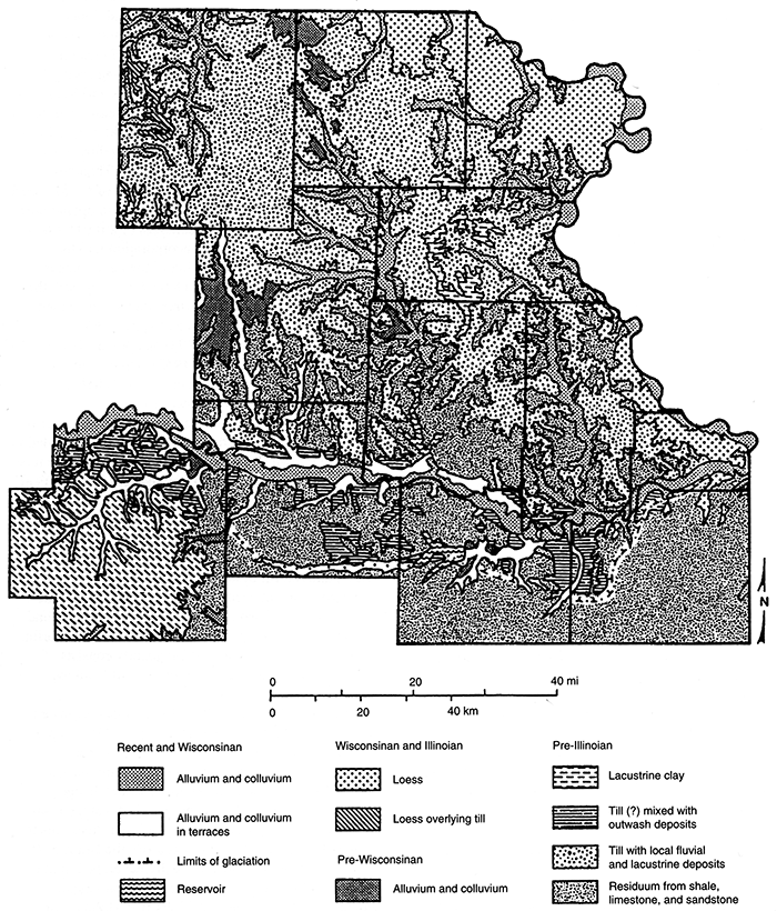
Figure 9--Quaternary map of northeastern Kansas.
The sediments of the Illinoian Stage consist of fluvial gravel, sand, and silt, and eolian silt, or loess, and sand. The Illinoian glaciers did not reach Kansas, and its closest approach has been identified in extreme eastern Iowa (Frye and Leonard, 1952). Illinoian deposits therefore result from the indirect effects of continental glaciation, including the cutting of stream valleys and eolian deposition. In northeastern Kansas, the Illinoian Stage is represented by alluvial deposits and the Loveland loess (Shimek, 1909). The alluvial deposits occur in the Kansas River valley, underlying the Buck Creek terrace (Davis and Carlson, 1952; fig. 8, Dort 1987b), which consists of deposits of basal sand and gravel grading upward into silt and clay. This terrace, topographically lower than the Menoken terrace, is based on the type locality at the Buck Creek school site on the north side of the Kansas River valley in southeastern Jefferson County (Davis and Carlson, 1952). The Loveland loess, the most wide-spread pre-Wisconsin loess in the midcontinent, is a reddish-brown or yellow-brown eolian silt with a maximum thickness of 20 ft (6 m) along the Missouri River valley (Zeller, 1968). Although the constraining ages of the Loveland Loess are unknown, Oviatt et al. (1988) reported thermoluminescence (TL) ages of 136 ka and 130 ka in the upper part of presumed Loveland Loess exposed in an abandoned quarry near Milford in Geary County. Feng et al. (1994) reported similar ages from Barton County, Kansas, as did Forman et al. (1992) for the Loveland paratype section in western Iowa. Also, Maat and Johnson (in press) reported a TL age of about 164 ka, 1.5 m (4.5 ft) below the Sangamon Soil at a loess exposure in southwestern Nebraska. The little regional environmental data available (fossil pollen; Kapp, 1965, 1970) indicate the loess fall occurred under relatively cool temperatures, high effective moisture, and open coniferous forest in south-central Kansas. The Loveland loess has thus far been recognized in Atchison, Leavenworth, Wyandotte, Doniphan, and Brown counties.
The Sangamon Soil (Leverett, 1899), representing the Sangamon Stage (marine isotope substage 5e), is well expressed throughout the state (Bayne and O'Connor, 1968), but has received considerable attention in the northeastern part (Frye and Leonard, 1949, 1952; Tien, 1968; Caspall, 1970; Bayne et al., 1971; Schaetzl, 1986). This soil zone is exceptionally well preserved and well developed and has been described in exposures along the Missouri River bluffs, including the Iowa Point section (Frye and Leonard, 1949) in Doniphan County. The Sangamon Soil consists of a dark-gray to grayishbrown A horizon and thick reddish-brown Bt horizon containing some caliche in the lower part. In Brown County, the soil has been documented as both a buried and exhumed soil (Schaetzl, 1986). The thickness can reach 24 ft (7.3 m) adjacent to the Missouri River valley (Zeller, 1968). Age of the Sangamon Soil is unknown, and it may be time transgressive in the midcontinent (Folmer, 1983). TL ages reported by Oviatt et al. (1988) and others place a maximum age of about 125 ka on the soil, whereas ages obtained on the overlying loess by Johnson (1993) in Phillips County, Kansas, and by Forman et al. (1992) and Leigh and Knox (1993) elsewhere in the midcontinent provide a minimum age of about 50 ka. Richmond and Fullerton (1986) designate 132-122 ka as Sangamon time, which is similar to the l30 ka derived using the orbital tuning technique (Martinson et al., 1987) and 120-125 ka obtained by the isotopic dating of fossil coral reefs (Edwards et al., 1987; Bard et al., 1990; Ku et al., 1990; Chen et al., 1991). A warm grassland environment is indicated for the Sangamon period from analyses of the opal phytolith morphology (Fredlund et al., 1985) and stable isotope composition (Fredlund, 1993) and from pollen (Kapp, 1965,1970) records.
The Wisconsinan Stage has traditionally been divided into several substages representing various episodes of glacial advance and retreat (Frye and Leonard, 1952; Wilman and Frye, 1970), but recent data indicate that the names and age limits of these substages should be abandoned here in Kansas (Johnson, 1993). The episodes occurred far to the north of Kansas in association with the near-glacier environment and affected land-surface response in the state mainly through loess deposition and fluvial activity. Two loesses were deposited during this stage: the Gilman Canyon Formation (Reed and Dreeszen, 1965) and Peoria loess (Leverett, 1899). The Gilman Canyon Formation occurs locally above the Sangamon and below the Peoria Loess. The formation is typically dark colored, rich in manganese ped coatings, leached of calcium carbonate, and heavily enriched, particularly in the upper part, with pedogenically derived organic carbon. Thickness of the formation ranges from only 2 to 4 ft (0.6-1.2 m), which, along with evidence of pedogenesis, reflects a relatively low rate of deposition. Radiocarbon ages on the formation range from over 38,000 yrs B.P. near the base to about 20,000 yrs B.P. at the top (May and Souders, 1988; Johnson, 1993). Regional expression and consistency of ages for the Gilman Canyon soil make it a geosol. Paleoenvironmental information emerging for the Gilman Canyon Formation of Kansas and Nebraska define a grassland dominated by warm-season species (Johnson, 1993; Johnson et al., 1993). The Peoria Loess is typically a calcareous, massive, light-yellow-tan to buff silt with scattered molluscan zones. Thickness ranges up to 100 ft (30 m) in the vicinity of the Missouri River, and it is present to a lesser extent on upland areas in a westward direction. Thicknesses of 2 ft (0.6 m) or less are undetectable due to incorporation into the modern surface soil. Deposition of the Peoria began about 20,000 yrs B.P., although the boundary with the Gilman Canyon Formation is transitional, and ended about 10,000 yrs B.P. Presence of spruce (Picea cf. glauca) remains (Johnson, 1993) and pollen (Gruger, 1973), snail fauna (Leonard, 1952), and evidence of cool-season grasses (Johnson et al., 1993) indicate existence of an open coniferous parkland.
The early Wisconsinan Stage was generally a period of valley deepening, and the fluvial record is recorded in alluvium known only through test drilling, because it is not exposed at the surface in northeastern Kansas (Fent, 1950; Frye and Leonard, 1952). In north-central Kansas, however, an alluvial facies of the Gilman Canyon Formation is preserved within a few feet of the terrace tread (Johnson, 1993). A 10,000-year-old soil buried within alluvial fill of the Kansas River basin indicates that entrenchment occurred sometime during the late Wisconsinan (Johnson and Martin, 1987; Johnson and Logan, 1990), perhaps about l3,000 years ago (Martin, 1990). Alluvium deposited subsequently consists of clay, silt, sand, and gravel derived in part from local glacial deposits.
The last 10,000 years of geologic time, designated the Holocene (Cohee, 1968; Hopkins, 1975), is represented by alluvium, periods of soil development, discontinuous loess deposits and thin colluvium on slopes. Major climatic and environmental change occurred in the early Holocene: a well-developed soil represents landscape stability in the latest Pleistocene/ earliest Holocene. This soil (a geosol), the Brady Soil (Schultz and Stout, 1948), typically developed in the uppermost Peoria Loess as deposition dramatically slowed or ceased about 10,500 yrs B.P. (Johnson and May, 1992). Presence of the Brady is defined by existence of the Bignell loess (Schultz and Stout, 1945) above it, and, since the Bignell loess is discontinuous, the Brady soil appears discontinuous as well. An alluvial phase of the Brady soil has been recognized throughout the Kansas River basin (Johnson and Martin, 1987; Martin, 1990; Johnson and Logan; 1990). The Brady soil has been documented in northeast Kansas, particularly Doniphan County (Frye and Leonard, 1951; Caspall, 1970, 1972). Brady pedogenesis ended about 9,000 years ago (Johnson, 1993), where Bignell loess began to accumulate, or as valley-bottom alluviation resumed. Early Holocene valley alluviation created the Newman terrace of the Kansas River valley (Davis and Carlson, 1952; fig.8, Dort 1987b). Subsequent entrenchment and alluviation in the Kansas River valley at 4,400 yrs B.P. or earlier (Johnson and Martin, 1987) resulted in the Holliday terrace fill (McCrae, 1954; fig.8, Dort 1987b). Radiocarbon ages of paleosols developed within Newman and Holliday fill indicate that the former is older than 10,000 years and as young as about 4,400 years, while the latter ranges from before 4,200 years to about 1,200 years ago (Holien, 1982; Johnson and Martin, 1987; Johnson and Logan, 1990). Major entrenchment occurred at about 1,000 yrs B.P. throughout the Kansas River system (Johnson and Logan, 1990). Subsequent alluviation produced a suite of low, ill-defined terraces and the modern floodplain. Changes in Holocene climate have been less dramatic than those of the Pleistocene, but yet a remarkable, extended dry period (the Altithermal: Antevs, 1955) developed and lasted from about 8,000 to 4,000 years ago. Unfortunately, very little climatic proxy data exist for the region and that which does is from the periphery of the prairie (Baker and Wain, 1985; Fredlund and Jaumann, 1987).
Previous Regional Studies Relative to the Quaternary
Early investigations of Quaternary deposits in northeastern Kansas were done by Smyth (1898), Todd (1909,1911, 1923), and Schoewe (1930a, b, 1931, 1932, 1933, 1939, 1941). Todd mapped the glaciated area of Kansas (including boulder fields and possible moraines) and discussed the formation of Kaw Lake, which resulted from ice blockage of the Kansas River during the Pleistocene. Smyth studied deposits along Shunganunga Creek in Shawnee County. Schoewe studied numerous glacial sections and found evidence that the glacial drift border was located farther south in Kansas than thought by earlier investigators.
Pleistocene stratigraphic studies include reports by Bayne and O'Connor (1968), Bayne (1968), Bayne et al. (1971), and Frye and Leonard (1949, 1952). Frye and Leonard (1952) co-authored the KGS bulletin Pleistocene Geology of Kansas. Aber (1981, 1982) presented lithologic data on glacial erratics and discussed a two-ice-lobe model for Kansan glaciation, and has most recently (Aber, 1991), proposed the Independence Formation as a new lithostratigraphic unit to include all diamicton and associated stratified sediment in northeastern Kansas. Bayne (1968) and Dort (1966, 1972b) presented evidence of multiple stades. Davis (1951) reported on gravels in northeastern Kansas, and Hanna and Bidwell (1955) investigated loessal soils in northeastern Kansas. Osterkamp and Wiseman (1980) discussed particle-size analyses of Missouri River basin alluvial materials. Chelikowsky (1976) found evidence of drainage reversal during the Pleistocene in the upper Tuttle Creek Reservoir. Schoewe (1931,1932,1933, 1941) and Jewett (1934) described glacial-striae locations in Kansas. Dellwig and Baldwin (1965) discussed evidence of ice-push deformation. Mudge (1955) wrote about the early Pleistocene geomorphic history in the southwestern glaciated area of northeastern Kansas. Heim and Howe (1963) described the Pleistocene drainage and depositional history of northwestern Missouri.
Other studies related to the Quaternary focus on buried valleys, structural characteristics, climatic factors, and ground-water quality. Beck (1961) studied a buried valley northwest of Manhattan, Kansas. Denne et al. (1982, 1984) described multiple approaches to locating glacial buried valleys. Structural characteristics of Nemaha County were investigated by DuBois (1978) and Steeples et al. (1979). Climatic factors during the Pleistocene were discussed by Dorf (1959), Dort (1965, 1970), and Fredlund and Jaumann (1987). Denneet al. (1984) and Denne et al (1987) investigated northeastern Kansas ground waters and the relation of their quality to aquifer materials.
Kansas Geological Survey and U.S. Geological Survey publications and maps focusing on the glaciated counties of Kansas include those by Bayne and Schoewe (1967) for Brown County, Bayne (1973) for Doniphan County, Jewett and Newell (1935) for Wyandotte County, Johnson and Wagner (1967) and Johnson and Adkison (1967) for Shawnee County, Mudge and Burton (1959) for Wabaunsee County; O'Connor (1960) for Douglas County, O'Connor (1971) for Johnson County, Scott et al. (1959) for Pottawatomie County, Walters (1953) for Jackson County, Walters (1954) for Marshall County, Ward (1973) for Atchison County, Ward (1974) for Nemaha County, and Winslow (1972) for Jefferson County.
Regional studies associated with the Kansas River valley include studies by Beck (1959), Davis and Carlson (1952), Dufford (1958), and Fader (1974). Bayne et al. (1971), Dort (1972a), Dreeszen and Burchett (1971), Emmett and Jeffery (1969), and LaRocque (1966) have published studies associated with the Missouri River valley. Other publications and maps that include general information on Quaternary geology for the Kansas City area and regions of northeastern Kansas are those by Davis and Carlson (1952), Fishel (1948), Fishel et al. (1953), and Ward and O'Connor (1983).
Prev Page--Introduction || Next Page--County Studies
Kansas Geological Survey, Geohydrology
Placed on web March 1, 2015; originally published 1998.
Comments to webadmin@kgs.ku.edu
The URL for this page is http://www.kgs.ku.edu/Publications/Bulletins/229/03_region.html