![]()
Prev Page--Contents || Next Page--Regional Studies
Introduction
As population increases, so does the demand for water, and thus ground-water supplies are gaining significance in northeastern Kansas. These supplies are especially important during times of low precipitation, when surface-water supplies decline. Although bedrock formations in the area generally contain little, if any, high-quality water (Moore, 1940), large quantities of freshwater can be obtained from deposits in glacial buried valleys. Because the extent and character of many of these deposits were not precisely known, a detailed evaluation was undertaken by the Kansas Geological Survey in cooperation with the U.S. Geological Survey.
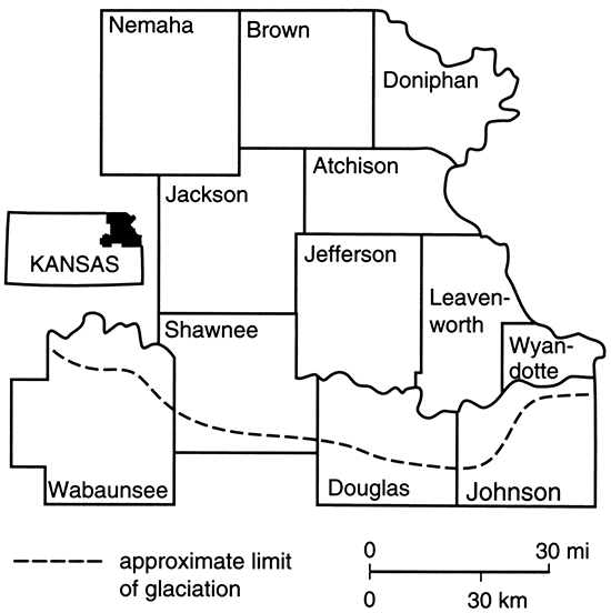
The general study area (fig. 1) covers 12 counties in northeastern Kansas that were entirely or partially glaciated during pre-Illinoian (classical Kansan and Nebraskan) time. Quaternary deposits exposed in the area include glacial drift (till, outwash, and lacustrine deposits), loess, and alluvium. Pennsylvanian and Permian shale, limestone, and sandstone bedrock formations occur near the land surface in other areas.
Figure 1--Buried-valley Study Area.
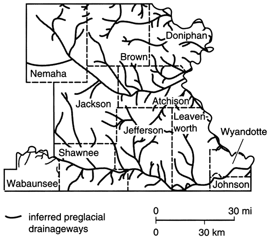
The general location of preglacial drainageways is shown in fig. 2. The buried valleys may be up to 3 mi (5 km) wide, 400 ft (120 m) deep, and more than 75 mi (120 km) long. Deposits filling these valleys range from clayey sediments to sand and gravel. Many of the buried-valley aquifers are confined; others are unconfined. Aquifer yields can reach 900 gallons per minute (gpm; 0.06 m3/s) but are generally less than 500 gpm (0.03 m3/s). Water levels are commonly 5-50 ft (2-15 m) below the land surface, but locally they may exceed 100 ft (30 m). However, measurements are complicated by the composite water levels obtained from single wells developed in multiple-aquifer systems using standard gravel-pack procedures. Well-construction methods also complicate analyses of water quality from the various aquifers. Although ground water from the buried valleys is generally of good quality, concentrations of nitrate, sulfate, chloride, iron, and manganese in excess of drinking water standards occur within the region.
Figure 2--Location of preglacial drainageways in northeastern Kansas; after Dreeszen and Burchett (1971).
To define the buried valleys, we compiled data from drillers' logs, engineering firms, and previous hydrogeologic studies. We drilled additional test holes and used geophysical (seismic, resistivity, temperature, gravity, and remote sensing) techniques to evaluate the channel locations and deposits. We used historical (late 1930's to 1973) and more recent (Spruill and Kenny, 1981) water-quality data for more than 1,200 wells in northeastern Kansas to evaluate the general quality of ground water in the area. In 1981, we collected 148 new samples (taken under controlled conditions of sampling, handling, and analysis) from wells with geologic logs and known construction characteristics.
Using a series of computer programs, we transformed the hydrogeologic data from the "free-formatted" county files (see Denne et al., 1990a) to a form that could be used with the KGS SURFACE II graphics system (Sampson, 1978). SURFACE II was used to plot data on county maps, and these maps were used to make interpretations and to hand-contour the bedrock surface elevations.
The five maps included for each of the 12 counties in this report were also plotted using the SURFACE II graphics system. Numerical data from the county files (see Denne et al., 1990a) were separated into selected ranges of values and plotted with certain symbols. The five map types are depth to bedrock, depth to water, total sand and gravel thickness, estimated well yield, and saturated thickness.
Prev Page--Contents || Next Page--Regional Studies
Kansas Geological Survey, Geohydrology
Placed on web March 1, 2015; originally published 1998.
Comments to webadmin@kgs.ku.edu
The URL for this page is http://www.kgs.ku.edu/Publications/Bulletins/229/02_intro.html