![]()
Prev Page--Contents || Next Page--Geology
Introduction
General
Nearly 100 million barrels of oil have been produced from the Gorham oil field, the second oldest oil field in the west ranges of Kansas. The geology, oil production, oil-field history, and the impact on the environment of this major 50 mi2 (130 km2) oil field are reviewed for the 6O-year period from 1926 through 1986.
The Gorham oil field is representative of the giant oil fields of central Kansas including Bemis-Shutts in Ellis County, Hall-Gurney and Trapp in Russell County (fig. 1), Kraft-Prusa (Walters and Price, 1948) in Barton County, and Chase-Silica in Rice County, Kansas. All are characterized by prolific oil production averaging 50,000 to 100,000 barrels of oil (BO) per well from carbonate rocks, the Arbuckle dolomite, and the Lansing-Kansas City limestones, at relatively shallow depths of 3,000-3,300 ft (900-990 m) from hundreds of oil wells on regular 10-acre (4-hectare) spacing, 660 ft (198 m) apart.
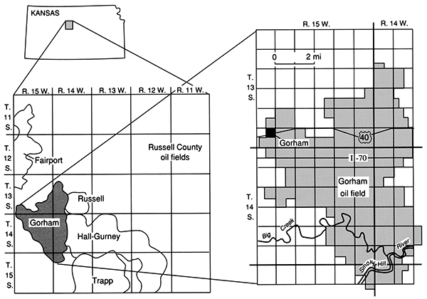
Figure 1--Regional index map showing the location of the Gorham oil field within Russell County, central Kansas. Interstate Highway 70 (I-70) and the town of Gorham are reference points shown on succeeding maps.
Location
The town of Gorham, from which the Gorham oil field is named, is 9 mi (14.4 km) west of Russell, Kansas, the county seat. United States Interstate Highway 70 (I-70) is located about 1 mi (1.6 km) south of both with exits at each, plus an exit in between at the Balta road within the Gorham oil field.
Fig. 1 shows the central Kansas location of Russell County and the official Gorham oil field boundaries as determined by the Kansas Corporation Commission (KCC), the State agency that regulates well spacing, oil production, drilling permits, and saltwater disposal.
Much of the area of the Gorham oil field consists of flat-lying farmland principally devoted to wheat growing. In the northeastern portion of the oil field, in T. 13 S., R. 14 W., the land is cut by canyons approximately 150 ft (45 m) deep which provide excellent outcrops of Cretaceous rocks. Structural mapping of these rocks led to the 1923 discovery of the Fairport oil field 10 mi (16 km) north of the town of Gorham. In the southern portion of the Gorham oil field, the valley of a west-to-east-flowing stream, Big Creek, provides outcrops of Cretaceous rocks, including "Fence-post limestone," a bed 8 inches (20 cm) thick, that was quarried by the pioneer settlers a little over a century ago to provide stone fence posts. Big Creek joins the east-flowing Smoky Hill River near the southeast corner of the Gorham oil field. The area is surveyed in land sections 1 mi2 (2.6 km2) with access roads on all section lines except in the rugged canyon areas where most roads follow valley floors and near Big Creek and the Smoky Hill River.
Area
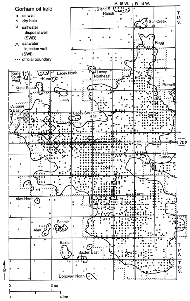
Fig. 2 shows 2,168 oil and gas test holes drilled within the 95.75 mi2 (248.95 km2) area mapped to December 31, 1986. Dry holes (wells that produced no oil in commercial amounts) are shown by open circles. Oil wells are shown by solid dots without regard to whether the well was still producing oil on December 31, 1986, or whether it had been previously plugged and abandoned. Included within the 50.5 mi2 (131.3 km2) official boundary of the Gorham oil field are 1,397 oil wells, 345 dry holes, and 85 service wells (used for disposal of oil-field brine) or 1,827 holes. These figures do not include the numerous additional holes drilled for water-supply wells, stratigraphic test holes, seismic shot holes, or the 162 known shallow saltwater-disposal wells.
Figure 2--Gorham oil field and vicinity, showing 2,168 oil and gas holes drilled within the 100 mi2 (260 km2) study area to January 1, 1987. Within the official boundary of the 50.5-mi2 (131-km2) Gorham oil field (/ / / / pattern) there were 1,397 oil wells, 345 dry holes, 41 saltwater-disposal wells, depths from 3,400 to 3,700 ft (1,020-1,110 m), plus 44 water-injection wells used in secondary recovery of oil by waterflooding.
Reservoirs
Five principal reservoir formations produce oil.
| Name used in oil field |
Depth in feet |
Number of oil wells* |
Percent of field's production |
|---|---|---|---|
| Tarkio | 2,400-2,500 | 130 | 8 |
| fracture zone | 2,700-2,800 | ||
| Topeka | 2,800-2,900 | ||
| Lansing-Kansas City | 3,000-3,300 | 477 | 25 |
| Arbuckle-Gorham sand | 3,300-3,400 | 1,044 | 67 |
| *Many oil wells produce from two formations, most commonly the Lansing-Kansas City and the Arbuckle-Gorham sand. |
|||
The entire 50 mi2 (130 km2) area of the Gorham oil field is a single oil field as defined by limits of production from its principal oil reservoir, the rocks associated with the basal Pennsylvanian unconformity including the Arbuckle dolomite, Reagan Sandstone, and parts of the "Gorham sand." This common oil reservoir has a strong water drive and an oil-water contact originally near 1,440 ft (432 m) below mean sea-level. It is now much distorted due to the withdrawal of millions of barrels of oil and perhaps ten times as much saltwater.
Within the official area of the Gorham oil field local, individual anticlinal areas are reservoirs for oil in the Pennsylvanian Lansing-Kansas City limestones. Limited oil reservoirs are present in the Shawnee Group, and Toronto and Plattsmouth limestones (called "Topeka"). Open fractures provided spectacular oil production from 30 "Topeka fracture zone" wells. Oil production called "Tarkio" occurs in Pennsylvanian Wabaunsee-age, silty sandstone lenses that are stratigraphic-trap reservoirs. In addition, minor production was obtained from fractures in Precambrian granite or quartzite on the summits of buried Precambrian hills, depths near 3,300 ft (990 m).
Literature, Gorham oil field
No study of the entire Gorham oil field has been published since Folger's (1933) four-page report for the period from discovery on October 16, 1926, to December 31, 1929, when there were 27 oil wells from which 1,108,004 BO had been produced, 70% from the Cambrian Reagan Sandstone (then called Pennsylvanian basal conglomerate) and 30% from the Pennsylvanian Lansing-Kansas City limestones (then called Oswald). Frye and Brazil (1943) reported timely important, but incomplete, groundwater studies in the Gorham oil field and elsewhere in Russell and Ellis counties. Walters (1953) discussed oil production from fractured Precambrian granite in the Gorham oil field, illustrated by a 9-mi (23.4-km)-long cross section. An abstract by Burgat and Taylor (1972) called attention to their investigation of two subsidence areas in the Gorham oil field affecting I-70 during its construction in 1965-67. Fader (1975) described and analyzed these subsidence areas. Walters (1978) investigated salt dissolution causing surface subsidence in the two areas along I-70 described by Burgat and Taylor and published a 1.25-mi (2-km) natural-scale cross section through them from the ground surface to the Precambrian basement. Macfarlane et al. (1988) reported on the hydrology of the Dakota, Kiowa, Cheyenne, and Cedar Hills aquifers. One observation well for this project is located within the Gorham oil field near the town of Gorham.
Statistical data concerning production of oil and gas in Kansas, including figures for the Gorham oil field and for the former oil fields now merged within it, have been compiled by various authors annually since 1927 for the Kansas Geological Survey. Their publications, used in preparing the production graphs (fig. 4), are listed in the appendix, table 8, under "Kansas Geological Survey" by year of contained data, not by year of publication, which was from one to five years later.
Discovery
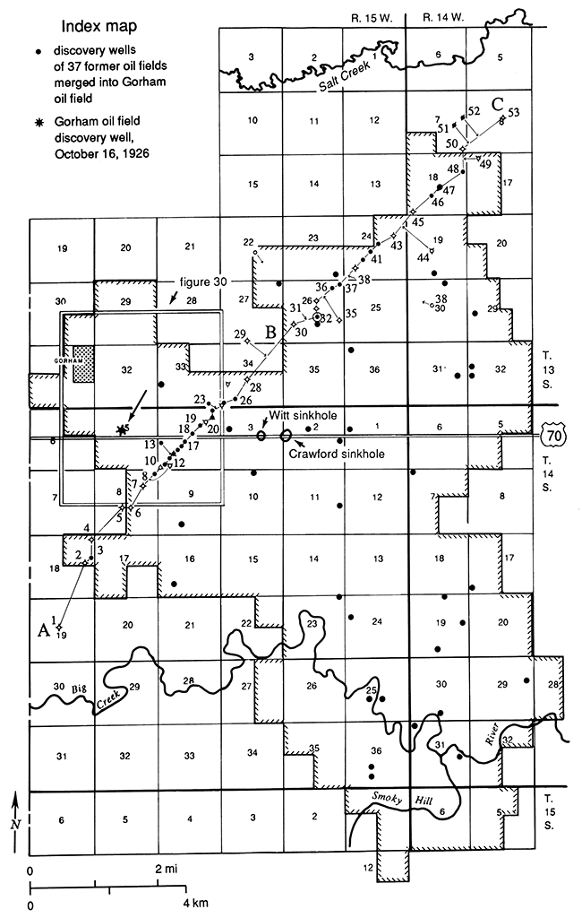
Oil was discovered in the Gorham oil field on October 16, 1926, in the "Oswald" (Lansing-Kansas City) limestone near 3,000 ft (900 m) by Midwest Refining Company's #36 Dortland in sec. 5, T. 14 S., R. 15 W., south of the town of Gorham and near present I-70. Fig. 3 shows the location of this discovery well, location of wells discovering 30 subsequent oil fields now merged into the Gorham oil field, and the location of cross sections and photographs. The most important of the subsequent discoveries was the finding of oil in the "Gorham sand" at 3,317 ft (995 m) near the town of Gorham on January 28, 1928, by Stearns and Streeter's Mermis #1 in sec. 33, T. 13 S., R. 15 W. The cover photograph shows the intense development taking place three months later when the panoramic photo was taken on April 14, 1928. It and many following photographs are reproduced through the courtesy of the Russell County Historical Museum of Russell, Kansas. Table 1 (appendix) lists the 31 discovery wells mapped in fig. 3 with pertinent additional information.
Figure 3--Index map of the Gorham oil field and vicinity. The squares are surveyed land sections of 1 mi2 (640 acres [2.6 km2; 256 hectares)), numbered from 1 to 36 in each township. All following geological maps are identical in area, but have the section numbers 1-36 omitted. The map shows the official boundaries of the Gorham oil field and the locations of 37 discovery wells of oil fields now merged into the Gorham oil field (listed in appendix, table 1). The original 1926 discovery well is shown by an arrow in sec. 5, T. 14 S., R. 15 W., near I-70 and near the town of Gorham. The map also shows locations of cross section A-B-C (figs. 5 and 6), the area included in the 1928 historical map (fig. 30), and the locations of the Witt and Crawford sink areas affecting I-70 (figs. 45 and 48). In the south portion of the map, Big Creek makes a 90° turn in its course in and near sec. 23, T. 14 S., R. 15 W., apparently controlled by underlying faulting in the Precambrian basement rocks (fig. 7).
Oil production
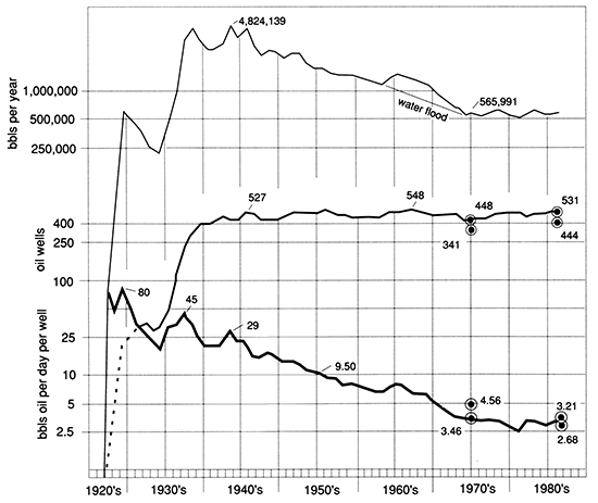
The Gorham oil field production history is summarized in fig. 4. The top graph shows annual oil production. The middle curve indicates the number of producing oil wells. The lowest curve graphs average daily oil production in terms of barrels of oil per day (BOPD) per oil well. The statistical information from which the graphs were prepared is summarized in the appendix, table 2.
Figure 4--Oil production, Gorham oil field, 1926-1986. Upper graph, annual oil production in barrels of 42 U.s. gallons; middle graph, number of active producing oil wells; lower graph, average daily production in barrels of oil per day (BOPD) per oil well. In the peak year of 1942, annual production reached 4,824,139 bbls of oil from 457 oil wells or 28.90 BOPD per well. The influence of extensive waterflooding of Lansing-Kansas City zones in the 1960's is indicated by the term "waterflood." Field well counts by the author of 341 active oil wells in 1974 and 444 in November 1986 provide figures of 4.56 BOPD and 3.21 BOPD per well, modifying lower curve of BOPD per well. Statistics from which graphs were prepared are given in the appendix, table 2.
Sources of information
The fundamental information for this study was derived from the examination of samples of well cuttings under a binocular microscope with 20x magnification. The author's early work in the 1940's made use of the then-available excellent cable-tool well cuttings that were suitable for acid insoluble residue preparation, permitting the author's subdivision of the Cambrian and Ordovician Arbuckle dolomite beds into five mappable units. In later years, samples of well cuttings were examined at, or borrowed from, the Kansas Geological Survey Well Sample Library in Wichita, Kansas, where samples are available to the public for a modest fee.
The author made extensive use of the resources of the Kansas Geological Society Library in Wichita, Kansas. Available to member geologists or to the public on a daily fee basis are extensive files of wire line geophysical logs, drilling-time logs, well-completion records, scout cards, drills tern test reports, geological reports written by the well-site geologist, and commercially prepared oil and gas production summaries on a lease by lease basis. (Publications of the Kansas Geological Survey also are available there but provide production information only by counties or oil fields, not by lease.)
The Kansas Corporation Commission (KCC) office in Wichita, Kansas, is the source of oil and gas production data, monthly, by leases. Production data are available to the public in the KCC office. The author found it much more convenient to access this information after it was abstracted by a commercial information company such as Petroleum Information, a company of the Dun and Bradstreet Corp. Well-plugging reports and saltwater disposal or injection well permits were inspected or purchased at the KCC office as they are not available elsewhere.
History
A summary of the development history of the Gorham oil field is included. In the 1970's the author was investigating land subsidence in central Kansas related to salt dissolution caused by human activities (Walters,1978). The geology of the Gorham oil field established that subsidence of I-70 was caused by dissolution of salt. However, to understand why salt was dissolved under the highway, and not under the entire oil field, required knowledge of the development and operating history of the Gorham oil field, including answers to many questions. When and how were wells drilled? How much casing was used? How was the casing cemented, if at all? How were the wells completed? How were the wells operated? How were the wells plugged after abandonment? Also required was an understanding of production problems. How were the large volumes of corrosive brine, produced along with the oil, handled? How did operators respond to severe corrosion causing casing leaks? While these questions were being investigated in the 1970's, Dr. William Hambleton, then Director of the Kansas Geological Survey (retired 1987), encouraged the author to record his knowledge of the development history of the Gorham oil field as representative of the history of the related, contemporaneous, major oil fields of central Kansas. Just as the thousands of oil derricks formerly present in the Gorham, Bemis, Hall-Gurney, Trapp, Kraft-Prusa, and Chase-Silica oil fields have entirely vanished (except in oil-field museums), so also the history of those oil fields, largely unrecorded, is rapidly vanishing. It should be preserved because the era represented a major new development in oil-field history. The oil fields of central Kansas, drilled from 1923 (Fairport) and 1926 (Gorham) through the 1940's, were characterized by prolific oil production from carbonate rocks (Arbuckle dolomite and Lansing-Kansas City limestones), at the shallow depths of 3,000-3,300 ft (900-990 m). Previously, sandstone reservoirs produced most of the oil from early oil fields as in Pennsylvania in the 1800's, in Oklahoma during the 1900's to 1920's, and in eastern Kansas, until the discovery of the El Dorado oil field in 1917. Dr. Hambleton and his successor Dr. Lee Gerhard considered it appropriate to conserve and publish this oil-field development history.
Environmental impact
Development of the Gorham oil field over 60 years is briefly reviewed in light of its impact on the environment in past years, at present, and in the future. Topics include subsidence, water supply, brine disposal, and agriculture.
Prev Page--Contents || Next Page--Geology
Kansas Geological Survey, Geology
Placed on web Jan. 30, 2015; originally published 1991.
Comments to webadmin@kgs.ku.edu
The URL for this page is http://www.kgs.ku.edu/Publications/Bulletins/228/02_intro.html