![]()
Prev Page--Introduction || Next Page--Sedimentation
Stratigraphy
Core and Sample Examination
Slabs from 940 feet of core from 14 wells were examined with a binocular microscope. Thin sections of 160 selected samples were examined with a petrographic microscope. Alizarin Red-S stain was used to differentiate dolomite from calcite. Detailed graphic and written lithologic logs of core sections were constructed, and environments of deposition were interpreted. Cores used in the study are in the core collection located at the Kansas Geological Survey in Lawrence.
Well cuttings (samples) from the entire Lansing-Kansas City stratigraphic section in 10 wells in Rawlins County were described; samples from two selected intervals in 25 other wells in Rawlins County also were examined. Description of samples was begun at least 100 feet above the zone of interest, rectifying the changes in samples to a well log to establish the sample quality and correctness of depth. Samples represent intervals of five to 10 feet; those used in this study are available from the Kansas Geological Survey Wichita Well Sample Library. Numerous wells in the area of interest have been drilled since completion of this report, and samples from most of these are available in Wichita. Selected cuttings, representative of an interval, were placed on a wire screen and gently bathed in 10 percent HCI for several seconds to remove the surface powder and polish the surface of the cuttings. When differential dolomitization or large differences in texture existed, etching made the dolomite or coarse crystalline areas stand out in relief and enhanced interpretations of the rock. After rinsing in distilled water, the samples were placed in a ceramic dimple-tray filled with water. In water, the samples were more clearly observed under the binocular microscope at magnifications varying from 10 to 40 times actual size. Selected cuttings were stained with a solution of Alizarin Red-S for 15 seconds to distinguish dolomite from calcite (Dickson, 1965). Thin sections were prepared from 35 selected intervals of cuttings for more detailed examination of rock fabric and for comparison with thin sections of samples from cores.
Log Correlation and Formation Evaluation
A subsurface correlation scheme was developed by Morgan (1952) using the radioactivity logs in central Kansas. The gamma ray-neutron combination is still the most common log used for evaluating the Lansing-Kansas City Groups. The limestones have also been named by some geologists according to their depth below the top of Lansing. In northwestern Kansas and along the Central Kansas Uplift both systems of nomenclature are usually in agreement; for example, the 180-foot zone corresponds with the "J" Zone. This suggests a rather consistent and predictable interlayering of carbonate and shale formations; Morgan, however, indicates that identification of beds based on penetration depth is incorrect over large lateral distances.
Northward on the Pennsylvanian shelf, including the present study area, frequent changes in composition of the rocks occur; in fact, in Nebraska, the carbonates are labeled differently because of the disappearance of several carbonate members. Morgan suggests that, in evaluating the Lansing-Kansas City, close attention should be paid to the thicknesses of the carbonates, because the highest subsurface elevation of a carbonate bed may not coincide with the highest structure at the top of Lansing. Thickening also is commonly associated with oil production. Identifying and explaining the significance of these areas of thickening is obviously important in locating and predicting trends of oil and gas occurrence.
Once a well is drilled, sufficient knowledge about the composition of each carbonate member is needed to make a conclusive evaluation. Zones with low permeability and high porosity may be treated with acid and result in a good completion. The bottom-hole pressure during a drill-stem test (DST) may be insufficient to allow significant in-flow of formation fluids, but additional information on properties of the rocks from samples or, preferably, cores and core analysis may provide the information needed to correctly relate the log and DST data and, in some cases, may result in a decision to complete a well that otherwise would have been abandoned. General knowledge of the type of carbonate facies in an area also would improve the selection of evaluation procedures in a drilling program. Accurate correlation throughout the area is, naturally, the first step in this procedure.
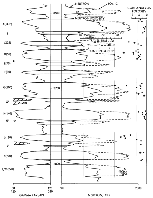
The log of the Conoco Adell L-KC Unit 406 well (Fig. 6) illustrates the correlation scheme used in this study. The carbonate units described here are referred to throughout the study as "carbonate zones," e.g., "A" carbonate zone. The intervening shales are not designated by letters but their relation to the carbonate zones is discussed in the next section.
Figure 6--Well log of the Conoco Adell L-KC Unit 406 from section 2-T6S-R27W. Letter system of correlation of carbonate zones is similar to that of Morgan (1952). Numbers indicate correlation system based on depth below top of Lansing. Vertical line segments along neutron, sonic, and core analysis porosity curves define eight percent porosity. In core analysis porosity data shown along right margin, data points indicated by stars have permeability greater than 0.4 md. Depths shown on logs are in feet. A larger version of this figure is available.
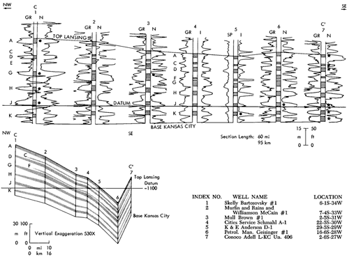
Structural and stratigraphic well-log cross sections (Figs. 7 and 8), using these letter-designated correlations, illustrate certain important aspects of the Lansing-Kansas City Groups: There is southward, basinward, thinning of clastic intervals between generally continuous or irregularly varying carbonates; the F and C carbonate zones pinch out northward toward the basin margin; and the contrast between the shales and carbonates in well logs diminishes northward.
Figure 7--Northeast-southwest stratigraphic cross section (B-B') of subsurface Lansing-Kansas City Groups across northern portion of study area. B-B' index line is found in Fig.. 2. Datum is the base of the J-Zone carboante. Upper and lower correlations are the top of Lansing and base of Kansas City Groups, respectively. Dots beside well logs define producing intervals of each well. Abbreviations for well logs are: GR = gamma ray; SP = spontaneous potential; N = neutron; S = sonic; I = induction. Inset section is a structure cross section along B-B'. Cleaner portions of major carbonate units are illustrated on this inset section. A larger version of this figure is available.
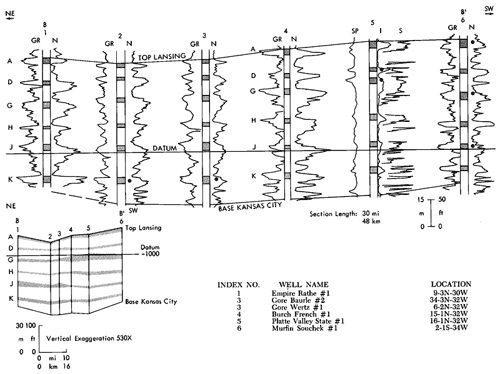
Figure 8--Northwest-southeast subsurface stratigraphic cross section (C-C') of Lansing-Kansas City Groups across southern portion of study area. C-C' index line is found in Fig. 2. Datum is the base of the J-Zone carbonate. Upper and lower correlations are the top of Lansing and the base of the Kansas City Group, respectively. Dots define producing intervals of each well except well #7, where water injection zones are indicated. (Abbreviationas in Fig. 7.) Inset section is a structure cross section along C-C'. Cleaner portions of major carbonate units are illustrated on this inset section. A larger version of this figure is available.
In the Skelly Bartosovsky No.1 well in Cahoj Field, Rawlins County (Fig. 2), there are four productive zones. The initial production of oil from that specific well was reported as 3,000 barrels of oil per day. Cahoj Field and immediately surrounding Cahoj East, Northeast, Northwest, and West alone include approximately 3,600 productive acres from which cumulative production from 10 carbonate zones (to 1978) has been 7,600,000 barrels of oil, or 70 percent of the oil from Rawlins County (Beene, 1979). One of the objectives of this study has been to compare Cahoj Field in northern Rawlins County with the surrounding area in southern Rawlins County in order to identify the factors that are important to the occurrence of oil in this part of Kansas.
Lithofacies
Cores described during this study are identified in Table 1. Three of the cores form a nearly complete representation of the Lansing-Kansas City Groups. One sedimentological characteristic is common to all cores, i.e., a basic 25 to 60 foot-thick sequence of certain types of carbonates and shales, which occurs repeatedly in the Missourian section and which comprises a cycle of sedimentation. Individual units of these cycles are more similar to equivalent units in other cycles than to other units in the same cycle. In this section, the individual units of a cycle are described and interpreted.
Table 1--List of names and locations of cored wells and carbonate unit(s) which were cored.
| Well Name | Spot Location | Cored Interval (ft.) | Carbonate Zones Found in Core |
|---|---|---|---|
| Kansas | |||
| Empire Palmer #10 | NENESE 6-1S-33W | 4055-74 | J |
| Murfin Souchek #1 | CSENE 2-1S-34W | 3959-65 | A |
| *4004-4037 | D,E | ||
| 4100-09 | H | ||
| 4121-25 | H' | ||
| 4140-54 | J | ||
| Skelly Bartosovsky #1 | SESWSW 9-1S-34W | 3960-4250 | A through M |
| Skelly Kisling #7 | CNWNW 10-1S-34W | 3994-4030 | A |
| 4171-74 | J | ||
| Cities Service Miller #2-1 | SENESE 31-2S-27W | *3680-3762 | A through H |
| Murfin Prentice #1 | CNENE 30-2S-35W | 4238-4278 | D,E |
| 4297-4323 | G | ||
| Cities Service Holmdahl A-1 | NESWSW 29-3S-31W | 3955-3991.5 | C through E |
| Conoco Adell Un. 406 | SESESW 2-6S-27W | 3583-3808 | A through M |
| Nebraska | |||
| Farmer Nicholson #1 | CSWSW 12-1N-27W | 3160-74 | D |
| Farmer Nicholson #2 | CNENE 14-1N-27W | 3153-68 | D |
| Farmer Nicholson #3 | CSWNE 14-1N-27W | *3154-70.5 | D |
| Gore Wertz #1 | CSESW 6-2N-32W | 3640-67 | D,E |
| 3688-3717 | G | ||
| 3738-53 | H | ||
| 3769-3814 | J | ||
| 3836-56 | K | ||
| Empire Rathe #1 | CNWSW 9-3N-30W | 3618-42 | D |
| 3653-74 | G | ||
| 3742-70 | J | ||
| *Incomplete interval | |||
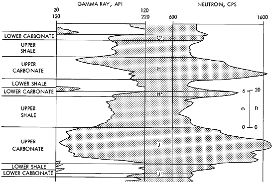
A typical cycle observed here is characterized by a thick "upper carbonate" unit and a thinner "lower carbonate" unit separated by a shale ("lower shale") of variable thickness. The "upper carbonate" zone is overlain by another shale ("upper shale"), as depicted in Figure 9. Each unit of the cycle has its unique characteristics, which allow recognition of the cycles throughout the Lansing-Kansas City section. The thick "upper carbonate" units include the A, D, G, H, J, K, and M zones in Figure 6. C and F zones develop into similar "upper carbonate" units south of the study area (Fig. 8). B, E, G', H', and J' zones represent the "lower carbonate" units. This system of letter-designated units corresponds to the usage established by Morgan (1952).
Figure 9--Gamma ray-neutron well-log signature of cyclic facies from an interval within the Kansas City Group. From bottom to top of a single cycle: Lower carbonate-lower shale-upper carbonate-upper shale. (Chief Drilling Co., VAP A-1, 21-1S-33W, Rawlins Co., Ks.).
The terms used to describe carbonate textures in this report are those proposed by Dunham (1962). "Lime mudstone" refers to a limestone with less than 10 percent grains in a lime-mud matrix. "Wackestone" refers to a mud-supported rock with more than 10 percent grains. "Packstone" is a limestone that is grain supported, but contains significant lime-mud matrix. "Grainstone" refers to grain-supported limestone that is mud-free.
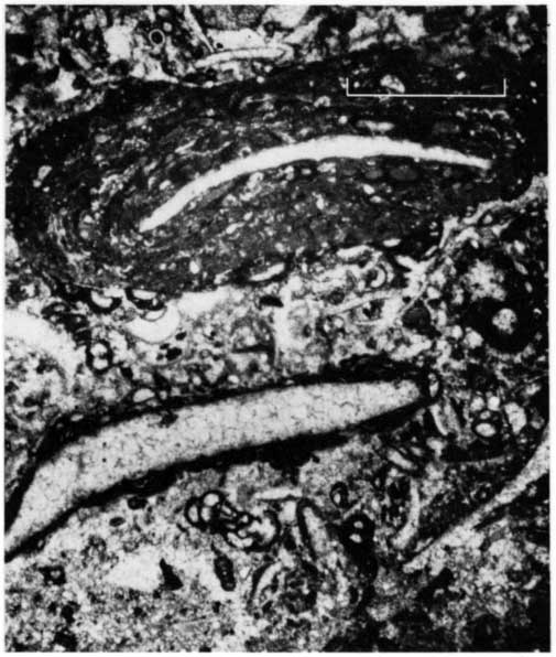
Lower Carbonate Unit-Beginning at the base of a cycle (Table 2), the lower carbonate (limestone) varies from tan or brown color near the base to brown -or gray-green at the top. The texture in the bottom usually is packstone or grainstone, which grades to wackestone or lime mudstone at the top. The contact at the base is sharp, and the top is gradational with the overlying shale. The lower grainstone or packstone, which is commonly burrowed, is composed of fine to coarse abraded bioclasts, predominantly fusulinids, crinoids, brachiopods, gastropods, pelecypods, and bryozoa. Recrystallized plate-like grains, possibly algae, are also common. These bioclasts usually are coated with algae and encrusting forams (Fig. 10). This coating is referred to as Osagia. Lime-mud intraclasts and quartz silt and sand grains are common.
Table 2--Description and interpretation of facies comprising the typical sedimentary cycel, which is the basis for the interpretation presented in the text.
| Descriptive Facies | Thickness (ft.) |
Lithology | Diagenetic Alternation |
Equiv. # in Fig. 36 |
Genetic Facies |
Depositional Environment |
|---|---|---|---|---|---|---|
| Upper Shale | <5-30 | Red-brown, unbedded silty shale |
intense | 7 | Regressive Shale |
Oxidized, continental clastics |
| Facies Contact: Sharp Contact | ||||||
| Upper (upper) | <1-15 | Lime-mudstone to grainstone common; occ. Dolomitic; sparse to very fossiliferou | moderate to intense |
3, 3a, 4, 5, 6 |
Regressive Carbonate |
Shallow, clear-water carbonate; tidal flat, lagoon, and open marine; high and low energy |
| Carbonate (lower) | 5-25 | Lime-mudstone or wackestone, argillaceous at bottom; fossiliferous | 2 | Subtidal, low energy, clear-water, open-marine carbonate grading downward to mixed turbid argillaceous carbonate | ||
| Facies Contact: Gradational Contact | ||||||
| Lower Shale |
2-20 | Fossiliferous, gray-green; occ. Black | minimal | 1 | Marine Shale |
Subtidal, low energy, marine; restricted, anoxic conditions prevalent to south and to north locally shallow water |
| Facies Contact: Gradational Contact | ||||||
| Lower (upper) |
0-15 | Lime-mudstone to wackestone, fossiliferous | minimal to locally moderate | 2 | Transgressive Carbonate |
Subtidal, low energy, open marine; clear to turbid water conditions |
| Facies Contact: Sharp Contact | ||||||
| Carbonate (lower) |
0-8 | Silty grainstone to packstone; occasionally, base rich in quartz sand or silt | unique combination of 2, 3, 4, 5 |
Sandy or silty reworked shoal water, intermittent restricted to open marine | ||
Figure 10--Thin section photomicrograph of a lower carbonate unit (J', 4196 ft., Bartosovsky #1). Osagia (blue-green algae and encrusting forams) coating on pelecypod fragments in silty, bioclastic lime-mud matrix. Bar scale equales 1 mm. PLANE-POLARIZED LIGHT.
In the upper, muddier part of the lower carbonate unit, brachiopods, fusulinids, and crinoids are the most common skeletal particles. Laminated and dispersed terriginous clay and silt increase upward. Disseminated organic matter is present with or without the association of disseminated pyrite. Locally, the muddy facies consists of an abundance of calcareous phylloid algae with associated encrusting forams (Fig. 11). This facies may thicken locally to nearly 20 feet, whereas it is more commonly one to 10 feet thick. The top of the zone is gradational with the overlying shale.
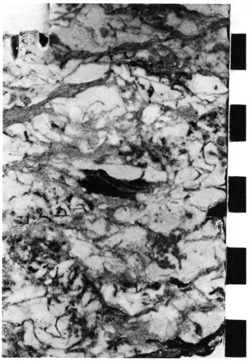
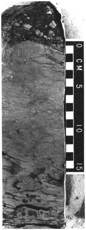
Figure 11--Core slab of a lower carbonate unit (E, 4271 ft., Prentice #1). Buff-colored phylloid algal wackestone with zones of oil-stained, partly recrystallized matrix and grains. Some matrix fracture and collapse. Divisions on bar scale equal 1 cm for each core slab.
The rocks in one core suggest that quartz silt and sand locally may develop in the lower part of this lower carbonate (Fig. 12) and may become a recognizable and distinct facies. This 10 feet of sand and siltstone is capped by a coarser, thin, sandy, grainstone bed, as described above.
Figure 12--Core slab of a lower carbonate unit equivalent (B, 4029 ft., Kisling #7). Selectively oil-stained, climbing ripple-laminated, quartz siltstone to sandstone.
Sedimentary structures include primarily burrow features that indicate reworking of the grain-rich sediment, including the quartz silt and sand facies. Ripple cross-laminations are common in the siltstone.
Diagenetic effects are generally minimal in the lower carbonate. Except for the addition of cement, the original texture is usually well preserved. At Cahoj Field, Rawlins County, oil is produced from a lower carbonate (E), which locally is a grainstone facies with intergranular and vuggy, secondary, leached porosity.
The environment in which the lower carbonate was deposited was relatively consistent for the equivalent members in each of the sedimentary cycles of the Lansing-Kansas City Groups. The bottom of the lower carbonate generally represents a high-energy, shallow marine environment. The Osagia coatings, scattered cerithid (high-spired) gastropods, encrusting forams, and presence of intraclasts probably indicate very shallow water. Crowley (1969) indicates that the Osagia may be analogous to modern oncolites (grains encrusted by blue-green algae). Ginsburg (1960) reports that oncolites are formed in low intertidal and shallow subtidal zones. Oncolites are present at depths of six feet and less on the Bahama Banks, in moderately agitated waters. Wilson (1975) indicates their formation in restricted marine bays and lagoons. The diverse fauna may indicate environmental conditions which fluctuated between open and restricted marine, or it may simply indicate organic mixing by burrowing organisms.
Quartz sand and silt at the base of the deposit, including scattered fossils as described above, suggest reworking of underlying clastic sediments in a shallow, moderately open or restricted, marine environment. The top of the lower carbonate unit represents a low-energy, subtidal, open marine environment in which turbidity increased with time.
Lower Shale Unit--The lower shale unit (Table 1 and Fig. 13) is green, olive to gray-green, gray, or black in color. The thickness ranges generally from around two feet in the southern study area to 20 feet in the northern study area. The fauna in this shale is usually diverse, with brachiopods, crinoids, and fusulinids being most common. Darker-colored intervals commonly contain phosphatic, inarticulate brachiopods. The upper portion of the shale may contain lime mudstone lenses and may be quite calcareous as it grades into the overlying upper carbonate unit. In the northern parts of the study area, the carbonate lenses also occur in the lower part of this shale interval. These lenses contain many cerithid gastropods and scattered ostracods.
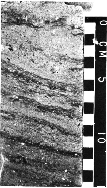
Figure 13--Core slab of a lower shale unit (immediately above E, 3985 ft., Holmdahl #1). Dark green, massive, brachiopod- and crinoid-bearing shale.
The lower shale may be burrowed, but usually the unit varies from massive to thinly laminated, to almost fissile. Obvious diagenetic alteration of the shale is limited to the northern part of the study area, where secondary discoloration due to oxidation occurs, resulting in mottled yellow and red colored or tinted shales. Fossil molds and fine fractures also are associated with this secondary alteration process.
Significant diagenetic effects in the lower shale are limited to the northerly areas. These include dissolution of calcareous fossils, oxidation of shale, and occasional fracturing, which are probably the result of percolating meteoric surface waters. These diagenetic events probably occurred before the shale was completely lithified and while fossil fragments were susceptible to dissolution.
The lower shales thicken northward, suggesting a source of fine, terrigenous clastic sediment in that direction. Changes in the character of the shale in some cycles suggest that the earliest deposition may have occurred in deeper, more restricted, low-energy, marine environments, or perhaps in marginal marine embayments, with temperature stratification and poor water circulation. Exceptions to this include those areas in which carbonate beds with fossils suggesting clear, shallow-water environments occur in these shales farther north. The carbonate beds that commonly occur in the tops of these shales indicate that the environment may have become shallower and less turbid with time, eventually leading to deposition of the upper carbonate unit.
Upper Carbonate Unit--The upper carbonate unit contains a diversity of carbonate rock-types that occur repeatedly at the same position within different zones. A division of the unit into an upper and lower interval is appropriate in this discussion (Table 2).
Lower Interval--The lower interval may be brown, gray, green-tinted tan, buff, or white lime mudstone or wackestone. Generally, the color becomes lighter and the carbonate contains less terrigenous clay and silt upward in the interval. The thickness range is from five to 25 feet. A diversity of fossils is present, with brachiopods, crinoids, and fusulinids being dominant. Corals, pelecypods, encrusting forams, benthenic forams, and bryozoans also are common.
Phylloid algae are locally abundant in this lower part of the upper carbonate (Fig. 14). The wavy, crinkled plates are usually jumbled in a mud matrix with no evidence of preferred orientation. Locally, the limestone is a packstone that consists, almost exclusively, of algae and smaller encrusting forams. In the northern part of the study area, in Hitchcock County, Nebraska, and locally over Cahoj Field, thin packstone and grainstone beds composed of mixed, fragmented skeletal grains are included in this lower interval. Burrowing is very apparent near the base of this more argillaceous interval (Fig. 15). Fragmented skeletal debris, which is common throughout the interval, suggests some biogenic reworking.
Figure 14--Core slab of an upper carbonate-lower interval (G, 4308 ft., Prentice #1). Long, wavy blades of phylloid algae. Also fusulinids, brachiopods, and encrusting forams. Some burrowing and collapse of matrix. Coarse calcite-spar filled voids.
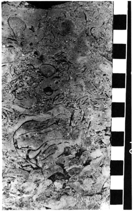
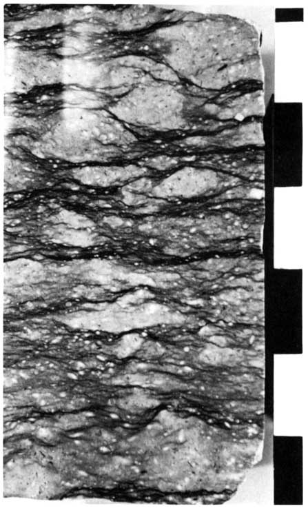
Figure 15--Core slab of an upper carbonate-lower interval (H, 4136 ft., Bartosovsky #1). Burrow-mottled, argillaceous, fusulinid, crinoidal wackestone. Burrows are light-colored, mottled areas among the wispy shale laminations.
Diagenetic effects are more important in the alteration of this interval than in the lower units of the cycle, especially in the more northern parts of the area. Typical postdepositional alteration in this interval includes the formation of molds, vugs, fractures, and fissures (Figs. 16, 17). The major effects of diagenesis in this facies, then, appear limited to an early period of freshwater percolation through mineralogically unstable and incompletely lithified carbonate sediment, with formation of some secondary porosity. The preceding illustrations and following discussion of the upper interval support this interpretation. In contrast, appreciable secondary effective (interconnected) porosity in the upper carbonate was formed in many areas, and in every upper carbonate unit of the Lansing-Kansas City cyclic sequence. Diagenetic processes may also have been related to the cause of the cycles.
Figure 16--Upper carbonate-lower interval illustrated by a photo pair (Slab: D, 3174 ft., Nicholson #1; and thin section photomicrograph: A, 3988 ft., Bartosovsky #1). Intense diagenetic alteration of wackestone with lime-mud dissolution, recrystalization, and fracturing. Both intervals were perforated for oil production. Photomicrograph taken under PLANE-POLARIZED LIGHT. bar scale 1 mm).
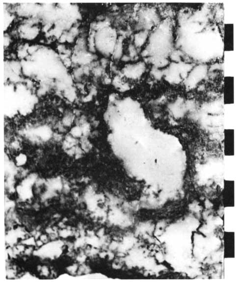
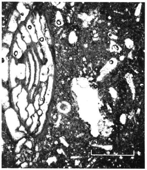
Figure 17--Core slab of an upper carbonate-lower interval (D, 4249 to 4250 ft., Prentice #1). Solution-altered, brecciated and fissured phylloid algal wackestone. Finely graded and laminated quartz silt and sand filling voids. Lies above interval with open, oil-filled vugs.
The rocks formed in a low-energy, subtidal, marine environment, but a few beds of abraded, grain-rich carbonates suggest occasional strong currents, with local winnowing and redeposition of sediment, perhaps by storms. Textural and compositional changes indicate that the water became less turbid with time. Phylloid algae developed during these periods of clear water.
Phylloid algae commonly occur in carbonate buildups, but are also found in horizontally bedded strata. They are thought to have been able to baffle and trap mud, which results in creation of depositional relief, in a manner similar to the effect of marine grasses in modern seas (Harbaugh, 1959). Wilson (1975) indicates that the algal mound may not originate from this trapping of mud, but that growth of the mound is encouraged by it. Ball and others (1977) conclude that the phylloid algae "were not builders of depositional topography, but rather were a source of building material." Regardless of these differences, apparent original relief above phylloid algal-bearing carbonate buildups is noted in many studies, including the present report. The mounds probably formed in water depths of 65 to 250 feet or less, and below wave base (Wilson, 1975).
Upper Interval--The facies of the upper interval of the upper carbonate unit (Table 2) are more complex and more variable laterally than those of the lower interval. The upper interval is generally light colored, with textures ranging through the spectrum from grains tones to lime mudstones. It is thinner than the lower interval, with thicknesses ranging from near zero to approximately 15 feet; average thickness is usually about three to five feet.
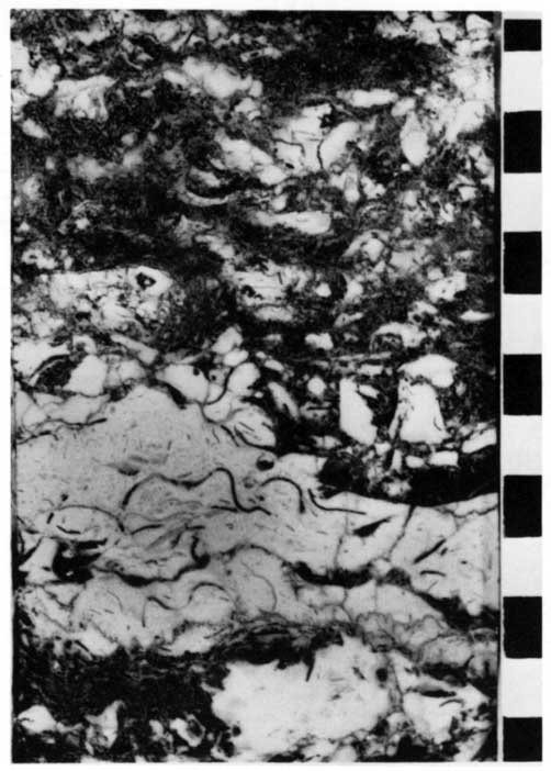
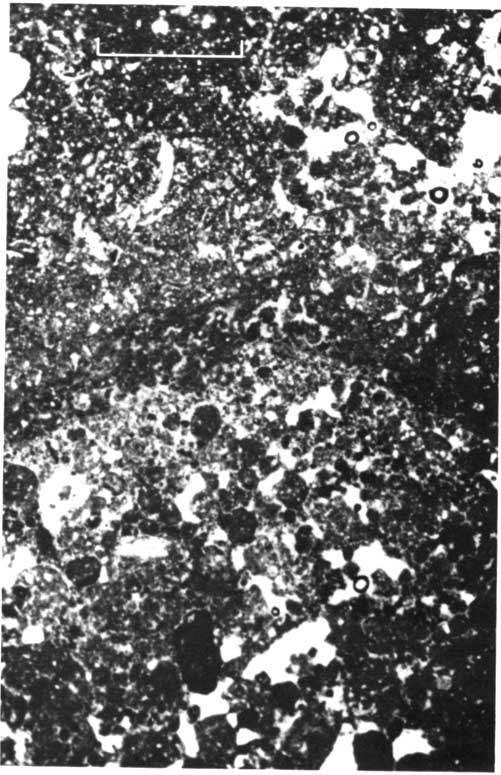
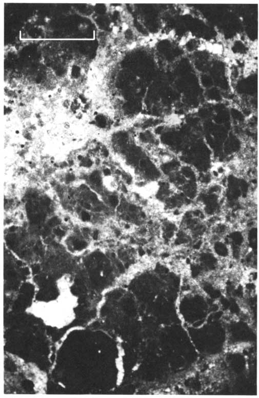
Diversity of fossils generally decreases toward the top of the interval, either gradually or rather abruptly. Grainstones may consist of coarse, abraded, mixed bioclasts (Fig. 18) or, in contrast, fine-grained, mixed pelloids, intraclasts, ostracods, forams, encrusting forams, and small bivalves. The muddy facies typically includes algal stromatolites and small numbers of organisms that occur only in restricted environments ( Fig. 19) . Disseminated quartz sand and silt are locally important in this facies in the northern part of the study area. Sedimentary structures include high-angle cross-stratification (Fig. 20) in coarse mixed-skeletal packstone, algal stromatolite (as noted above), lime mudstone intraclast conglomerate, and, most commonly, organically disturbed or burrowed beds of packstone or grainstone.
Figure 18--Upper carbonate-upper interval (J, 3761 ft., Adell Un. 406). Abraded fusulinid brachiopod, crinoid, bioclastic grainstone; grains moderately to heavily micritized; grain surfaces darkened prior to precipitation of thin, bladed, isopachous carbonate rim (now calcite); scattered chert replacement of crinoids; abundant intergranular porosity. On crinoid fragments are coarsely crystalline, calcite, syntaxial overgrowths which precipitated later then the early isopachus (probably marine) cement. (Core analysis porosity = 18%, permeability = 42 md.) CROSS-POLARIZED LIGHT. Bar scale equals 0.25 mm.
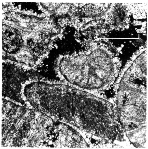
Figure 19--This section photomicrograph of an upper carbonate-upper interval (F, 3675 ft., Adel Un. 406). Silty, dolomitized, algal stromatolite showing generally horizontal laminations of darker calcite or dolomite between finely graded silty to muddy carbonate layers. Laminations occaisionallly disturbed by vertical burrows and fluid-escape structures. Other evidence of fauna is generally lacking. CROSS-POLARIZED LIGHT. Bar scale = 1 mm.
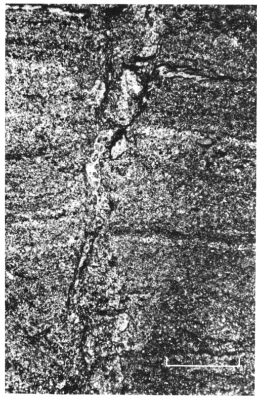
Figure 20--Core slab of an upper carbonate-upper interval (J, 4149 ft., Souchek #1). Cross-stratified, leached, fusulinid, robust brachiopod, crinoid, bioclastic packstone (productive facies; well completed in three zones for 152 BOPD).
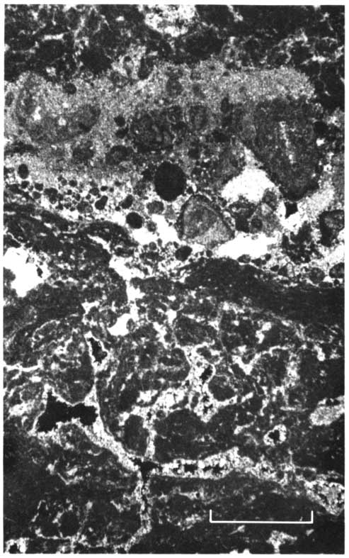
Diagenetic effects are much more evident in this facies than in the underlying lower interval. Internal sediment commonly occurring in vugs and fissures is composed of shale like that overlying this unit, silt, or clasts of carbonate wall rock and resistant bioclasts (Figs. 21, 22). Associated features include overcompacted grainstone fabrics with individual grains, which are highly micritized and embayed (Fig. 23). Intergranular porosity may be either enhanced by dissolution or occluded by coarse, sparry calcite cement. More extreme effects include in situ brecciation and erosion of the top of this carbonate zone (Figs. 24, 25).
Figure 21--Thin section photomicrograph of an upper carbonate-upper interval (J, 4063 ft., Palmer #10). A fissure several mm wide, on far left, is loosly filled with resistant, microtized bioclasts and wall rock fragments cemented by blocky, coarse calcite spar. Wall of fissure illustrates heavily altered carbonate (diagenetic overprinting). Dissolution, recrystalization, and precipitation products include a dark, poorly laminated, very thin carbonate crust adjacent to the fissure, coating a finely pelletoid and mottled packstone. Note the circular void surrounded by dense micritic lime mud at right center; this is a root cast, similar in form to those which occur in the overlying upper shale. PLANE-POLARIZED LIGHT. Bar scale equals 1 mm.
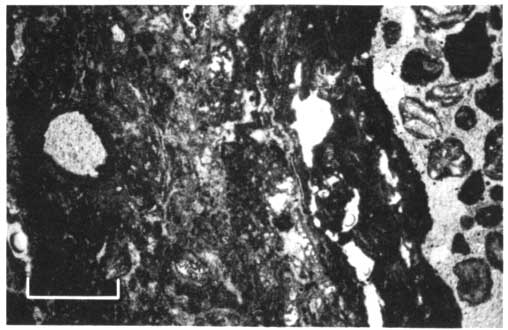
Figure 22--Thin section photomicrographs of an upper carbonate-upper interval (J, 4064 ft., Palmer #10). Areas illustrated are adjacent in specimen, and they illustrate a fissured area completely filled with rounded, resistant bioclasts and wall rock debris. Note corroded fusulinid in the upper right in the lower photo. In contrast, the fusulinid in the unaltered wackestone on the left in the upper photo is well preserved. Note the sharp vertical contact between the unaltered wall rock and the "crumbly fracture" (Dunham, 1969). Photographed in PLANE-POLARIZED LIGHT. Angular shaped, black-colored areas are pyrite. Bar scale equals 1 mm.
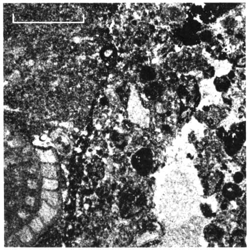
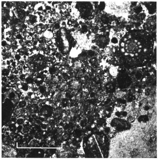
Figure 23--Thin section photomicrograph of an upper carbonate-upper interval (D, 3160 ft., Nicholson #1). Brachiopod, fusulinid, crinoid, bioclastic grainstone-packstone.. Brown-stained, leached, embayed grains, moderate to heavily micritized. Solution-enhanced intergrannular porosity between grains illustrates overcompaction. (Zone perforated for production.) PLANE-POLARIZED LIGHT. Bar scale equals 1 mm.
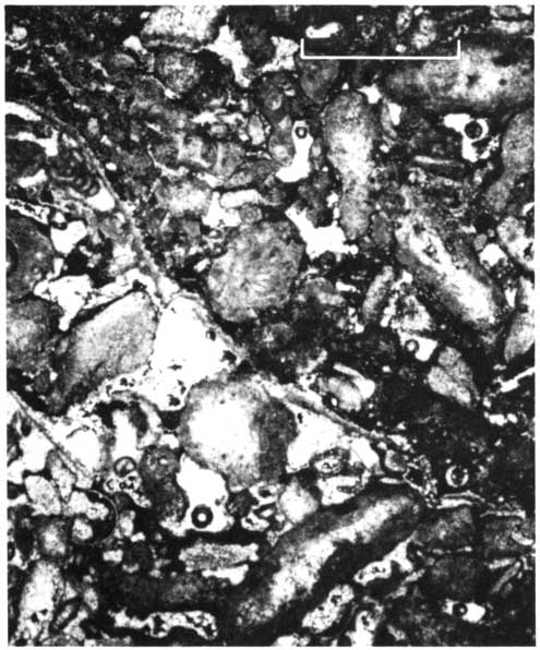
Figure 24--Core slab of an upper carbonate-upper interval (A, 3981 ft., Bartosovsky #1). In situ brecciation of lime mudstone-wackestone with "clasts" in green shale. Adjacent carbonate contains solution cavities filled with the same green shale. Surface corrosion and fracturaing of carbonate are common. Top 2 ft. (0.7 m) of the interval contain corroded, dessicated carboante clasts in red shale matrix. Note elongate, irregular shapes of some of the carbonate "clasts."
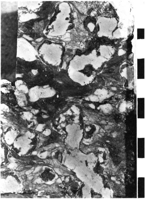
Figure 25--Core slab of an upper carbonate-upper interval (G, 3663 ft., Rathe #1). Mixed-size and -type, rounded to oangular, solution embayed carbonate clasts (generally containing restricted, or no, fauna) in red-brown shale matrix, which itself contains residual, resistant bioclasts. Top of interval (1 ft.) contains floating carbonate clasts in red shale. Note that clasts are surrounded by pink-to-tan, micritic calcite (see also Fig. 32).
The upper interval of the upper carbonate unit typically includes shoal-water facies, which may be capped by deposits formed in restricted, shallow water environments. The high-energy, shoal-water, marine deposits (Fig. 18) consist of coarser-grained, abraded bioclasts, many of which are highly micritized and worn in appearance because of the activity of boring organisms and the abrasion resulting from transport by waves and currents. Although sorting of grain sizes is good in these deposits, there are few coated grains present. Actual oolite grainstone occurs only in the core from Adell Field (Fig. 26), in the extreme southeastern part of the study area. The grains tones usually are several (two to six) feet thick, but not as thick as those reported in Lansing-Kansas City formations farther south (Brown, 1963; Hopkins, 1977).
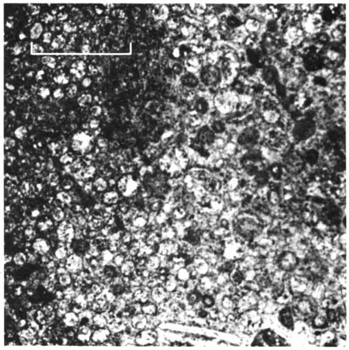
Figure 26--Thin section photomicrograph of an upper carbonate-upper interval (F, 3672 ft., Adell Un. 406). Fine-grained oölitic grainstone containing finely recrystalized oöids, voided oöids filled with coarse blocky spar, occaisional bivalves including brachiopods, scattered quartz silt, all cemented by finely crystalline calcite. PLANE-POLARIZED LIGHT. Bar scale equals 1 mm.
Wave and current energy appears to have been more limited on this upper shelf location than it was farther south. Where present, the high-energy deposits may represent beaches, offshore shoals, or tidal bars. Their location probably depended on local bathymetric relief or on local change in slope of the bottom, which would have focused current and wave energy and resulted in well-winnowed deposits. Carbonate buildups or other prominences on the shallow shelf would be obvious places to look for these types of deposits.
Restricted marine, intertidal, or supratidal carbonate deposits (Fig. 27) commonly cap this upper carbonate interval. The restriction may have resulted from poor circulation over a broad shallow shelf, from the lack of strong currents in a lagoon blocked off from open water by a shoal, or from the presence of tidal flats or low-relief islands. The salinity in these environments varies from normal marine to hypersaline or, possibly, brackish. Morphologic features include mud flats, ponds, marshes, tidal channels and levees, and storm berms. These conditions comprise a highly variable stress environment; consequently, few indigenous skeletal particles occur in the deposits. The fine-grained carbonate formed there commonly includes occurrences of microcrystalline dolomite (Deffeyes and others, 1965).
Figure 27--Core slab and thin section of an upper carbonate-upper interval (slab photo: H, 3756 ft., #1 Miller "Z"; photomicrograph: J, 4181 ft., Bartosovsky #1). Slab: Very top of carbonate containing rotated carbonate clast in gray-green shale at top, fragmental "fitted" clasts below this, and horizontally and vertically fractured buff-colored carbonate mud at bottom. Note small fenestral, spar-filled voids within the carbonate along the center of the core. Photomicrograph: Partly dolomitized, pelletoid, ostracod-bearing packstone-wackestone containing scattered irregular cavities, some apparently circumgranular-type, aprtly filed with coarsely crystalline dolomite. PLANE-POLARIZED LIGHT. Bar scale equals 1 mm.

Microcrystalline dolomite replaces lime-mud and scattered skeletal grains and also is present filling voids left by the dissolution of some particles (Land, 1973). The dolomite occurs predominantly in the restricted marine or intertidal-supratidal deposits, but is found also in underlying open-marine carbonates. Smaller results of dissolution such as embayed grains and smaller vugs and molds may also be due to the dolomitization process (Deffeyes and others, 1965). Several samples have coarse anhydrite crystals filling previously open voids and replacing some of the coarser void-filling dolomite. This microcrystalline dolomite may be similar to dolomite occurring in modern mud-flat deposits, which results from contact of the fine carbonate sediment with magnesium-rich brine soon after deposition. But some of the dolomite, especially that in the underlying marine carbonate units, may have resulted from contact of these deposits by meteoric water percolating downward through the overlying dolomite after the sediments were above sea level, but before they were mineralogically stable (Land, 1973).
Evidence of early subaerial exposure and of diagenesis caused by freshwater is common in the upper interval of the upper carbonate unit. During deposition, tidal-flat, fine-grained carbonate deposits developed fenestral fabric and desiccation cracks in response to repeated wetting and drying (Fig. 27).
Soil profiles and related structures formed at the top of the upper carbonate in several zones of the Lansing-Kansas City Groups. These features occur in different parts of the study area in different zones (Fig. 28), implying that exposure of the carbonate deposits to subaerial weathering happened repeatedly and involved actual relative changes in sea level that differed in magnitude through time. This subaerial exposure was very important in enhancing or modifying the reservoir quality of some of the limestones. The processes of soil formation were more intense northward and were continued during deposition of the shale above the upper carbonate.
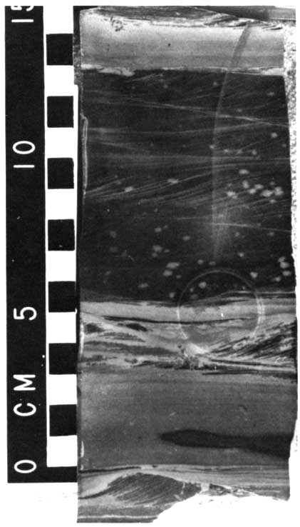
Figure 28--Core slab of an upper carbonate-upper interval (F, 3755 ft., Miller Z-1). Dolomitized, finely discontinuous laminated lime-mud containing scattered altered skeletal fragments including crinoids. Intensely altered carbonate with dominant horizontal and minor vertical fractures, some filled with red shale. Overlying red shale contains carbonate clasts. Note near-original orientation of the clasts in the lower right portion of the shale just above the more continuous carbonate surface.
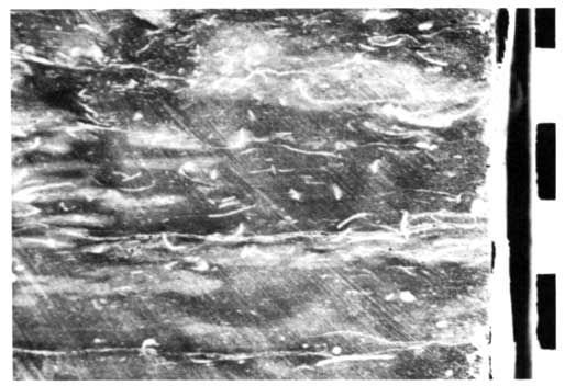
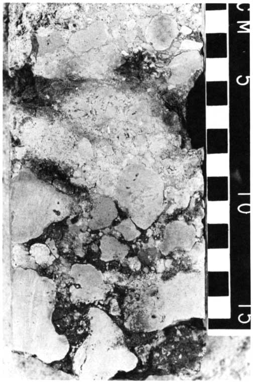
Crinkly laminated crusts (Fig. 29) capping some limestones are similar to those forming on the Pleistocene limestone exposed in south Florida (Multer and Hoffmeister, 1968) and other areas. Clotted and laminated texture (Fig. 29), circum granular cracks (Fig. 30), non-tectonic crumbly fractures (Dunham, 1969) (Fig. 22), and fossil root tubes (Figs. 21, 29) are further testimony to the soil-forming processes that altered the original fabric of these rocks (Enos and Perkins, 1977; Harrison and Steinen, 1978). In-place brecciation, dissolution, fragmentation, and possibly erosion and transportation caused more drastic changes in the limestones. These processes were more intense northward, suggesting that the frequency of occurrence of nonmarine environments increased in that direction.
Figure 29--Core slab and thin section of an upper carbonate-upper interval (G, 4301 ft., Prentice #1). The slab's upper 2 cm is a brown crustose, micritic, vuggy layer capped by a surface of pyrite. This carbonate layer contains fine tube-like cavities (pedotubules) lined with dense micritic carbonate sometimes stained dark red-brown. This crust-like layer is in abrupt contact with underlying bioclastic packstone, which is cut by vugs and extensive horizontal fractured. The photomicrograph reveals a crinkly, laminated, probably accretionary deposit of dense, micritic carbonate cut by numerous tube-like voids. Some portions appear pelletoid. This micritic carbonate lies directly on a bioclastic packstone. PLANE-POLARIZED LIGHT. Bar scale equals 1 mm.
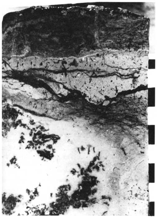
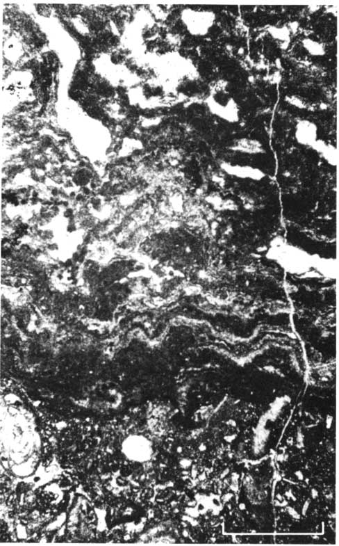
Figure 30--Thin section photomicrograph of an upper carbonate-upper interval (F, 3718.5 ft., Miller Z-1). The upper, light-colored area is a portion of a large subhorizontal sheet crack partly filled with debris of resistant bioclasts and wall rock. Both fine micritic calcite and coarser blocky spar fill this void. Many of the fractures and solution-enhanced fissures below this sheet crack and witin the dense pelletoidal matrix surround "grains," i.e., they are circumgranular. Coarse, blocky calcite crystals fill remaining void space. CROSS-POLARIZED LIGHT. Bar scale equals 1 mm.
Diagenesis significantly altered the porosity distribution in the upper carbonate units of several Lansing-Kansas City zones. Primary porosity is either enhanced by dissolution or occluded with calcite cement. Secondary porosity developed in some units is substantial, and these limestones constitute good, permeable reservoir rocks. This secondary porosity may be predictable, because certain facies are more susceptible to leaching by freshwater; i.e., more metastable bioclasts are present, and secondary porosity is best developed where these units approach their northward limit or at a location of local paleotopographic development (Fig. 31).
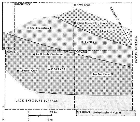
Figure 31--Variation in intensity of freshwater diagenesis and subaerial exposure across the area of study affecting the G-Zone carbonate (based on available core data). Limited data suggest northward (landward) increase in intensity of freshwater diagenesis with appreciable subaerial exposure.
Upper Shale Unit--The upper shale unit caps each sedimentary cycle (Table 2). This clastic unit characteristically has a red-brown color, except that, locally, it may be green, olive, or gray. Intervals may be quite silty or sandy, but the deposit is predominantly a silty, micaceous claystone. Thickness ranges from less than five to 30 feet, and it may vary substantially over short distances.
The upper shale is very sparsely fossiliferous. Locally, a thin layer of marine fossils occurs near the base of the unit, where it may contain soft, green, pyritic claystone with tan lime mudstone lenses. Nodules of pink or buff-colored microcrystalline calcite or dolomite are scattered through the shale, contributing to its mottled appearance. The shale is usually massive, with occasional slickensides, and it breaks with a blocky fracture. It contains tubular, shale- or calcite-filled structures with diameters of one to five mm.
Diagenetic effects in the upper shale are important to understanding its origin. The typical red-brown color may be, in part, post-depositional. Calcite nodules commonly occur with shrinkage fractures, circular and elongate vugs and fissures, and with gray-green, yellow, red, and maroon mottling in the shales. Vugs are frequently filled with limonitic, dull yellow-green or hematitic, maroon-colored shale (Figs. 32, 33, 34).
Figure 32--Core slab of an upper shale (J, 4164 ft., Bartosovsky #1). Red-brown silty shale containing abundant fine, white, calcareous tube-like concretions (pedotubules) and cm-sized pink to buff-colored micritic carbonate mottling (incipient calicheification) cut by occasional fractures.
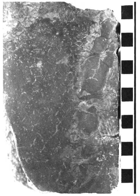
Figure 33--Thin section photomicrograph of an upper shale (J, 4166 ft., Bartosovsky #1). Pedotubule consisting of a rounded void surrounded by micritic carboante, partly filled by black (opaque) hematite along the upper portion of the void with the remainder filled by clear, coarse calcite. The surrounding grains are quartz silt. PLANE-POLARIZED LIGHT. Bar scale equals 0.25 mm.
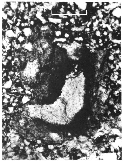
Figure 34--Thin section photomicrograph of an upper shale (D, 3648 ft., Wertz #1). Clotted, Fe-oxide-stained, crypto-crystalline calcite (caliche) with well-developed circumgranular fractures filled with sparry calcite. Quartz silt grains have been displaed or dissolved during formation of caliche. PLANE-POLARIZED LIGHT. Bar scale equals 1 mm.
The environment of deposition of the upper shales is closely related to the processes of diagenesis that affected them. The absence of fossils, the oxidized appearance, and the nodular carbonate in some layers all suggest a subaerially exposed continental deposit. The absence of primary bedding, the tubule structures, and calcite nodules may be a result of soil-forming processes and of plant-root action similar to that observed in some ancient fresh- and brackish-water lake and marsh deposits (McBride, 1974). The observed green patches and fine mottling are thought to result from removal of limonite grain coatings as ferrous-organic complexes in reducing soil water (Hubert, 1977). The process may have been related to decay of plant roots.
These features of upper-shale units probably represent paleosoils. The carbonate nodules closely resemble the properties of caliche micrite (Reeves, 1970). The circular and elongate vugs, with associated cryptocrystalline calcite, and iron oxide-rich clay are similar to pedotubules described in recent soils (H. Dickey, personal communication, 1978).
Analyses of samples from a paleosoil horizon (Table 3) indicate that the proportion of feldspar decreases and of mixed-layer clay minerals increases with depth in the paleosoil. The total amount of clay is highest and of carbonate is lowest at the base of the soil zone. This variation in composition may be related to the original composition of the parent material of the soil or to the soil-forming process itself. Gile and Grossman (1968) describe reddish-brown, sometimes very calcareous, horizons in the desert soils of southern New Mexico. Montmorillonite in these desert soils is an important component of the clay. It may be the precursor to the mixed-layer clay observed in this study. Microcrystalline aggregates, which are mostly altered feldspars, are common in New Mexico desert soil. The decrease in feldspar and increase in mixed-layer clays noted in this Pennsylvanian paleosoil may be associated with the destruction of feldspar during soil formation. Oriented clay-coated sand grains and clay-lined pedotubules are also found in the desert soil mentioned above. The clay coatings on the grain surfaces are preferred sites for initial carbonate precipitation. If enough carbonate accumulates, it can obliterate these coatings and can completely engulf parts of the soil horizon.
Table 3--Estimated major-mineral composition of the paleosoil above J-Zone carbonate in Skelly Bartosovsky #1. X-ray diffraction analyses by G.W. James.
| Major Minerals (Volume %) |
||||||
|---|---|---|---|---|---|---|
| Position | Depth (ft.) | Quartz | Feldspar | Clay | Calcite | Comment |
| Above soil | 4162 | 40 | 20 | 20 | 20 | Minor mixed-layer clays |
| Near top paleosoil | 4165 | 35 | 15 | 20 | 20 | Increase mixed-layer clays |
| Near bottom paleosoil | 4167 | 40 | 10 | 40 | 10 | Further increase mixed-layer clays |
Soils that are similar to the paleo soils described here also occur in the Texas Panhandle (U.S.D.A., 1976, p. 223, 249), suggesting that the ancient climatic conditions may have been similar (semiarid) to those in northwestern Texas. These subaerial conditions are an extension of those that affected the upper carbonate zone and that were so important in modification of porosity in the carbonate.
Prev Page--Introduction || Next Page--Sedimentation
Kansas Geological Survey, Cyclic Sedimentation
Comments to webadmin@kgs.ku.edu
Web version Oct. 2004. Original publication date Oct. 1980.
URL=http://www.kgs.ku.edu/Publications/Bulletins/220/04_strat.html