![]()
Prev Page--Stratigraphy || Next Page--Exploration
Epeiric Shelf Sedimentation
Epeiric Sedimentation of the Lansing-Kansas City Groups
A vertical sequence of four basic lithofacies units, which is repeated several times to form the LansingKansas City Groups, has been described. Each sequence comprises a cyclothem, or a cycle of sedimentation. A brief genetic description of these units is provided in Table 2.
A similar vertical sequence has been recognized in other localities in other basins. The lower carbonate at the base of the sequence records an inundation of the area by seawater and local reworking of underlying clastics. The lower shale represents a period of clastic influx that occurred at a time of maximum inundation. As the water began to clear, carbonate deposition began under still intermittently turbid conditions. The clearing of the water also corresponded with a period of shallowing when low-energy, open-marine carbonates were overlain by shallow-water facies of the upper carbonate zone. Shallowing continued to a point at which the area was emergent, and subaerial processes became dominant during deposition of the upper shale. Each succeeding cycle represents transgression and regression of the different environments of deposition across a broad epeiric shelf (Heckel, 1977, 1980).
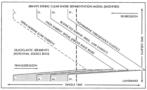
Shaw (1964) and Irwin (1965) proposed a deductive model of clear-water, epeiric-shelf sedimentation to describe similar lateral and vertical aspects of some ancient carbonate stratigraphic sequences. One of the basic requirements for this model is a broad, low-relief, marine shelf with a slight depositional slope, such as that in western Kansas and adjacent areas during Lansing and Kansas City time (Fig. 4). According to this model, differences in direction and strength of water circulation and degree of agitation were present across the Lansing-Kansas City shelf. Several trends of sedimentary environments lay parallel to the northern strandline or to the southern shelf margin, each reflecting hydrographic, climatic, and other ecologic factors, and proximity to a northern source of terrigenous clastic sediment.
Relative rise or fall of sea level resulted in the migration of these environmentally controlled facies across the shelf. This lateral migration and overlapping of facies is also recognizable in the vertical succession of rock types in the Lansing-Kansas City. As the western Kansas shelf subsided, generally similar types of sediments were repeatedly deposited (Fig. 35). Variations in this typical cycle of sedimentation resulted from differences in the relative changes of sea level, rates of subsidence, or other factors. Diagenesis of parts of these cyclic sequences also varied with these same factors, especially in the northern part of the shelf where subaerial exposure of the regressive units was accompanied by alteration by freshwater.
Figure 35--Modified version of Irwin's epeiric, clear-water, sedimentation model similar to that proposed by Coogan (1969). The illustration portrays greatly simplified variations in facies across the shelf with time during a coplete cycle of transgression and regression. Distribution of facies at any instant in time would be the facies that occur along a single horizontal line through the diagram. The transgressive event is relatively rapid and is represented by a districtive, unique deposit (patterned area) similar to facies II, III, IV in the regressive phase of the cycle. The vertical dashed line represents the typical facies components of a cycle, as observed in this study.
Wilson (1970) and Armstrong (1974) also suggest pertinent details of facies distribution across a low-relief carbonate shelf. This conceptual model (Fig. 36) applies well to the sediments described in this report. In seaward areas of the shelf, a low-energy zone exists below wave base. Marine shales are deposited farthest off shore and open-marine lime mudstones and wackestones are deposited closer to shore. Landward, waves and stronger currents winnow the bottom sediments. Maximum organic .productivity is generally associated with the shallow agitated environments, resulting in abundant skeletal debris being available to form deposits of abraded grainstone and packstone. Oolite grains tones formed in a similar high-energy environment where carbonate-saturated seawater was agitated, perhaps by currents interacting with bathymetric prominences.
Figure 36--Modified version of a platform depositional model after Wilson (1970) and Armstrong (1974). Seven basic contemporaneous depositional environments are shown, including subtidal marine deposition most distant from shore, through facies representing coastal and an emergent continental environment. Environments are numbered as described in Table 2. A larger version of this figure is available.
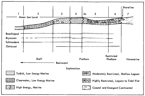
The action of waves and currents was minimal in some other locations on the shelf, which may have been too flat and shallow over broad areas. Poor circulation of shallow water produces mud-supported facies landward of the high-energy accumulations, representing restricted lagoonal or tidal flats. Finely crystalline dolomite is common in the restricted facies, and is probably the result of early dolomitization of lime-mud in the nearshore environments. In the study area, elements of this carbonate platform model are extended landward to include red-brown shales and silts that interfinger with the adjacent shallow marine carbonates.
Lansing-Kansas City Cycles of Sedimentation--Interpretation
The idealized models described above may be used to interpret the cyclic events that resulted in the Lansing-Kansas City Groups in northwestern Kansas and contiguous areas. According to the epeiric model, the shelf is first inundated through subsidence and or eustatic sea-level rise. This transgression results in a rapid landward shift of facies (Fig. 35). The shelf, being essentially flat, receives deposition of a thin, very widespread transgressive unit, the lower carbonate unit described in Table 2. This deposit is a unique condensed section containing fossils, representing rapid change from shallower- to deeper-water carbonate platform conditions. It may consist of any of a number of types of sediment, including phylloid algal limestone, sandy bioclastic limestone, quartz sandstone, fusulinid-bearing lime mudstone, and others, depending on local conditions (Elias, 1962; McCrone, 1963; Wilson, 1967; Toomey, 1969; Heckel, 1980).
Approximately at the culmination of transgression (maximum marine inundation on the shelf), marine shale, equivalent to the lower shale unit described earlier, was deposited. Terrigenous clastics are also important later in the cycle and are probably related to renewal of a northern, landward source. Clastic influx may have begun early during transgression and could have overcome the general shelf inundation in some areas during this phase, particularly along the upper shelf margin near the source area. As noted in other areas (Wilson, 1967), these clastics, deposited during transgression of the sea, may cause a local "regression" of the shoreline, thus complicating the cycle. With delta abandonment or other change in clastic influx, relative sea-level rise again dominates.
The upper portion of each cycle constitutes a regressive, or progradational, phase of deposition (upper shale and carbonate units of Table 2). In a dip direction (basin ward), these facies are diachronous and seem to become younger seaward. Rates of local regression may exceed regional regression as carbonate buildups develop. Rates of subsidence and eustatic sea-level change also were important in determining the extent and nature of these regressive sediments.
The upper carbonate unit (Table 2) includes facies deposited in open-marine to restricted-marine environments (Fig. 36). Because it represents regressive sedimentation, this carbonate is also referred to as the regressive carbonate unit.
Shelf location, sea-bottom configuration, water circulation patterns, and other factors affect the trends and development of the shoal carbonates in this unit as they prograde out onto the shelf. These shoal-water carbonates have been the most attractive targets for oil exploration in this area thus far.
Continued regression resulted in subaerial exposure of the regressive carbonate zone in the northern portion of the study area. Subaerial crust formation, in situ brecciation, and erosion affected the carbonate in this area. The duration and intensity of exposure to subaerial weathering increased northward. Early freshwater diagenesis significantly influenced the present distribution of porosity in these rocks.
Oxidized, subaerially exposed upper shale (Table 2) is characteristic of the study area. This deposit is the culmination of the regressive process, as the shoreline advanced basinward and continental sedimentation became the important process. This shale is referred to as the regressive shale.
The thinness or general absence of channel sands, gray shale, coals, and underclay suggest the absence in northwestern Kansas of active delta growth that is so commonly associated with rocks of equivalent age in eastern Kansas (Heckel, 1977, 1980). In eastern Kansas, fluvial channel sands in thick shales and erosion of these channels into the underlying regressive carbonates are common and, in some cycles, the influx of clastic sediment periodically overwhelmed and terminated regressive carbonate deposition (Heckel and Baesemann, 1975, p. 499).
The abundant terrigenous clastics that complicate the cycles in eastern Kansas and in north-central Texas (Van Siclen, 1964) are probably related in part to higher rates of rainfall than occurred during deposition in northwestern Kansas. The aridity of the Upper Pennsylvanian climate increased from the Appalachians to the Ancestral Rockies during the late Pennsylvanian (Heckel, 1977). Evaporites and eolian red beds are more common in rocks of equivalent age to the west, including localities in South Dakota and Wyoming.
In the southern part of the study area, two of the regressive shales include thin carbonate units that become thicker southward (the C and F carbonate zones in Figure 8). Associated with these carbonates are green and gray shales. The carbonates have the characteristics of marine to restricted marine, or tidal-flat, deposits. Core from an up dip, equivalent, redbrown shale interval contain embayed and fractured pieces of dolomitic, tidal-flat carbonate. These thin, unusual carbonates represent a relatively limited transgression, probably more as the result of a brief sea-level rise than of a variation in sediment progradation. South of the study area these carbonates are thicker, sometimes capped with grain-rich carbonate including oolite. Landward, beyond the carbonate pinchout, the equivalent shale interval includes dark gray-green and unfossiliferous shale between red-brown oxidized shale (Bartosovsky, 4158 ft. to 4162 ft.). Compared to other transgressions, only partial inundation of the landward shelf could readily account for this sediment sequence.
The updip limits of these limestones coincide with an area of intense freshwater diagenesis in carbonates that are dominated by shoal-water facies. Similar facies relationships probably also are present in the extreme up dip extensions of the major regressive carbonate zones where they wedge out northward (in Nebraska) into terrigenous clastics.
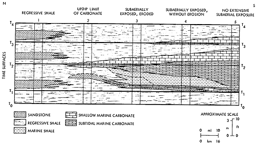
Figure 37 is a generalized model of cycles such as those of the present study, in the area of transition from mainly carbonate to clastic sediments, illustrating the lateral facies variation through time. With very low-angle depositional slopes and rather broad facies belts, the contacts between the succeeding facies are essentially flat. A typical cycle of sedimentation includes transgressive and regressive components, including a regressive carbonate zone that is most likely to become porous oil and gas reservoir rock.
Figure 37--A conceptual stratigraphic model that depicts lateral and vertical relationships of facies within a major sedimentary cycle in the study area. This model is based on analysis of seven Lansing-Kansas City cycles. The updip pinchout of the regressive carboante zone into the regressive shale is based indirectly on known pinchouts of the F and D carbonate zones within the study area. Subaerial exposure is indicated along the northerly updip surface of the regressive carbonate (illustrated by the wavy upper surface). Updip sands in the regressive shale interval are hypthetical. Oblique dashed line in the marine shale divides restricted (left) from ore open marine (right) conditions. The well log in Figure 44 is divided into cycle-divisions that are the same as those illustrated here. A larger version of this figure is available.
Each cycle of sedimentation will be referred to in following discussion as a zone cycle, e.g., G-Zone Cycle, which includes the G regressive carbonate zone (Fig. 6). The components of these cycles are equivalent to those of Heckel (1977), e.g., transgressive (or lower) carbonate = middle limestone; marine (or lower) shale = core shale; regressive (or upper) carbonate = upper limestone; regressive (or upper) shale = outside shale.
Environments of deposition and of subsequent diagenesis were very important in the development of potential hydrocarbon reservoir rocks in these cyclic sequences. Of particular note, early freshwater diagenesis was extremely important in the northern part of the study area and over local topographic highs. It is readily apparent from cores of wells (Table 4) that both grain-supported and matrix supported carbonates have become reservoir rocks. Only with secondary diagenetic changes could the low-energy, mud-supported carbonates have become porous and permeable, e.g., through partial dissolution and non-tectonic fracturing (Figs. 11, 16). Most of the grainstone reservoirs also show evidence of enhancement of porosity by these same processes (Fig. 23). Overall, evidence indicates that freshwater diagenesis had a substantial positive effect on the development of oil and gas reservoirs in the study area (Watney and Ebanks, 1978).
Table 4--Representative cored reservoir facies in study area.
| Well | Spot Location |
Initial Production |
Producing Zone |
Porosity Thickness |
Maximum | Reservoir Description | |
| Poros. (%) |
Perm. (MD) |
||||||
| Skelly Bartosovsky #1 |
9-1S-34W SESWSW |
1000 BOPD | HMID | 5' | 22 | 211 | Wackestone with heavy freshwater alteration-lime-mud dissolution |
| JMID | 4' | 20 | 160 | Dolomitized lime-mudstone with appreciable mud recrystallization | |||
| JLOWER | 3' | 16 | 2150 | Freshwater altered wackestone (as H) | |||
| Murfin Drlg. Co. Prentice #1 |
30-2S-35W CNENE |
16 BOPD | DMID | 7' | NA | NA | Freshwater altered phylloid algal wackestone to packstone |
| Conoco Adell L-Kc Un. 406 |
2-6S-27W SESWSW |
wtr. Injection | CTOP | 4' | 14 | 3.5 | Freshwater altered bioclastic packstone |
| JTOP | 6' | 21 | 69 | Coarse-grained, diverse bioclastic grainstone with preserved primary porosity | |||
| Gore Wertz #1 |
6-2N-32W CSENW |
105 BOPD twtr. | KTOP | 4' | NA | NA | Hearvy freshwater altered, fine bioclastic, pelloid wackestone to packstone |
| Farmer Nicholson #1 |
12-1N-27W | 25 BOPD + 25% wtr. | DTOP | 2' | 11 | 10 | Fine to coarse grained, diverse bioclastic packstone to grainstone with heavy freshwater alternation and mud dissolution |
| DLOWER | 2' | 13 | 27 | Heavy freshwater altered wackestone with abundant grain and mud dissolution with fine fractures | |||
Oil- and gas-producing intervals within the study area include every carbonate zone present. Seven zones are productive in a single well in Cahoj Field, Rawlins County, Kansas. Ninety-seven percent of the production and 90 percent of the wells are located on the Cahoj structure complex in northern Rawlins County. The J- and G-Zones have been perforated most frequently in this area. In Red Willow County, Nebraska, the D-Zone is the most commonly productive unit; in Hitchcock County, Nebraska, it is the J- and K-Zones (Fig. 2). Facies variations within a single zone result in different reservoir types occurring in different areas; consequently, evaluation and completion practices may differ for the same producing zone from place to place.
Prev Page--Stratigraphy || Next Page--Exploration
Kansas Geological Survey, Cyclic Sedimentation
Comments to webadmin@kgs.ku.edu
Web version Oct. 2004. Original publication date Oct. 1980.
URL=http://www.kgs.ku.edu/Publications/Bulletins/220/05_sed.html