![]()
Land Subsidence in Central Kansas Related to Salt Dissolution
By Robert F. Walters
Originally published in 1978 as Kansas Geological Survey Bulletin 214. This is, in general, the original text as published. The information has not been updated.
Executive Summary
The Hutchinson Salt Member of the Permian Wellington Formation underlies 27,000 square miles in central and south-central Kansas. Near the city of Hutchinson, the salt has a gross thickness of 350 feet, including shale and anhydrite interbeds totaling 20 percent of the section, or a net of 280 feet of rock salt (mineralogically halite, chemically NaCl) of variable purity. It is there encountered near 400 feet, but elsewhere at depths ranging from 200 feet to over 2500 feet. Within Kansas, the margins of the Hutchinson Salt are depositional edges except for the updip east edge which is solution eroded due to access to the Pleistocene and present water tables. West of this natural erosion border, there are no instances of dissolution of the Hutchinson Salt prior to man's drilling test holes for oil or salt during the past 88 years, the inadvertent effects of which are the 13 subsidence areas described in this paper, five associated with the mining of salt and eight resulting from oil and gas operations.
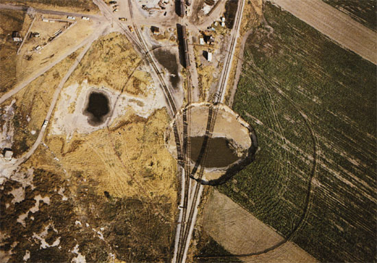
In 1914, subsidence within the salt works of the Joy Morton Salt Company southwest of Hutchinson affected an area 150 feet in diameter with a vertical depression of 15 feet, demolishing part of the plant. In 1925, the operation of Carey Salt Company's brine wells in downtown Hutchinson resulted in vertical subsidence of a few inches within a circular area, diameter 600 feet, and horizontal movement of 2 1/2 inches affecting the east end of the court house. In 1952, ground north of the Barton Salt Company plant (now Cargill, Inc.) in the southeastern portion of Hutchinson subsided. In 1974, a sinkhole 300 feet in diameter formed in three days time south of the same plant, leaving railroad tracks suspended in air. Volume of the sinkhole is 90,000 cubic yards, with water level 21.5 feet below the ground surface and maximum water depth of 39 feet. A research project of the Solution Mining Research Institute, Inc. in which eight shallow holes were drilled within the sinkhole from a barge one year later, indicated nearly flat bedrock at a depth of 70 feet, except for a central area about 100 feet in diameter down which displaced sand and gravel moved into void space associated with the removal of salt. Near Ellsworth, Kansas in 1972, collapse of the material filling the shaft of an abandoned dry salt mine resulted in a surface crater 129 feet by 95 feet, 60 feet deep, with a volume equal to four times that of the original mine shaft 790 feet deep.
The most intensely studied subsidence areas associated with oil operations are the Crawford and Witt Sinks in the Gorham oil field west of Russell, Kansas. Subsidence during a 20-year period of more than 26 feet and 17 feet at three abandoned oil wells affected 1000 feet of U.S. Interstate Highway 70 at each location, necessitating costly repairs. A research test hole drilled through the salt, depth near 1300 feet, demonstrated conclusively that subsidence--which is still continuing at a rate of one-half foot per year--is caused by dissolution of the Hutchinson Salt. In contrast, rapid subsidence occurred at the Panning Sinkhole in the Chase-Silica oil field near Ellinwood, Kansas, on April 24, 1959 as photographed by Larry Panning. A circular pit 300 feet in diameter and 85 feet deep developed in a few hours around a plugged and abandoned salt water disposal well 3850 feet deep in which the Hutchinson Salt was penetrated from 975 feet to 1275 feet. Two miles east, the land subsided slowly for 15 feet vertically from 1972 to 1976 around the Berscheit salt water disposal well, causing a pond to form 375 feet in diameter. Events leading to this sinkhole are similar to the history of the nearby Panning Sinkhole, but the final event, rapid collapse resulting from inflow of loose sand and gravel, could not occur because alluvial fill is absent at the Berscheit location. A similar sinkhole developed slowly near Chase, Kansas before 1964 around twin salt water disposal wells, the Hilton No. 6 and No. 7, where a pond 350 feet in diameter formed due to 18 feet of vertical subsidence.
Evidence is presented that solution of salt during modern rapid rotary drilling using fresh water results in borehole enlargement to about three times the diameter of the drilled hole, and that early rotary drilling in the 1930s resulted in borehole enlargement to five feet or more in diameter through the Hutchinson Salt. Both amounts are too small to cause surface subsidence.
Ordinarily, no salt dissolution occurs after drilling ceases. This important principle is valid if shallow aquifers above the salt are adequately isolated by surface casing and/or by proper hole plugging as required by regulations of the Kansas Corporation Commission. This is the normal situation in the broad ten-county study area. The subject was investigated by a study of the ten principal aquifers, depths to 4000 feet, which are oil reservoirs wherever hydrocarbon trapping conditions exist. In boreholes with properly isolated shallow aquifers above the salt, the deeper aquifers below the salt--although possessing static fill-up levels higher than the top of the salt--will equalize pressure by flowing up or down the borehole from one aquifer into another without flow across the salt face, hence without dissolving the salt. This is true for all such oil and gas test holes regardless of how else the borehole is plugged, if at all. This is a fundamental reason oil-field-related subsidence areas are rare and are confined to situations where aquifers above the salt are not isolated by surface casing (Gorham oil field, Witt and Crawford Sinks), or where casing failures in salt water disposal wells permitted extensive flow of unsaturated brine across the salt (Chase-Silica oil field, Panning, Berscheit, and Hilton Sinkholes).
It is a conclusion of this extensive search for, and report on, land subsidence areas in central Kansas associated with rock salt dissolution that such subsidence areas attributable to man's activities are rare and unusual features. Oil-related subsidence areas occur in a ratio of one to each 10,000 holes drilled through the Hutchinson Salt. Subsidence areas related to the mining of salt average only one for each 17 years for 88 years of continuous salt production.
It is an important observation of this investigation that all surface subsidence areas in Kansas related to salt removal have a common history of slow development in a time frame of months and years, but where near-surface materials consist of water saturated unconsolidated sands and gravels, and the underlying bedrock layers are breached, a surface sinkhole formed in a few hours or days.
Kansas Geological Survey, Geology
Placed on web July 24, 2009; originally published February 1978.
Cover photo: Sinkhole, Hutchinson, Kansas, October 22, 1974. View north toward Cargill, Inc. salt plant. The Missouri-Pacific Railroad tracks are suspended 21 feet above the water level in the stil1 enlarging sinkhole. Circular shadow marks protective fence. Abandoned brine wells are located between and west (left) of the railroad tracks. Well 35, airlift brine return well, is near the left margin (building and derrick). Well 62, connected under ground with the sinkhole, is located (smal1 square) in the bottom left-hand corner. Photograph courtesy Deming Studio, Hutchinson.
Comments to webadmin@kgs.ku.edu
The URL for this page is http://www.kgs.ku.edu/Publications/Bulletins/214/index.html