![]()
Prev Page--Introduction || Next Page--Mineralogy and Paleontology
Stratigraphy
Structural Setting
Jewett (1951) provided a concise summary of the major structural features of Kansas. Reed (1954) indicated the Nebraska names for extensions of the structures identified by Jewett. As examples, Table Rock Arch is the Nebraska name for the famous Nemaha Anticline of Kansas, and Central Nebraska Basin is the Nebraska name for the northern extension of the Salina Basin of Kansas. It should be interesting to observe the relations of the Red Eagle cyclothem to these structures, because if they existed in Red Eagle time they might have influenced the cyclothemic sedimentary facies.
In southern Kansas (Cowley and Elk Counties) the Red Eagle Limestone crops out in a belt close to and paralleling the axis of the Otto-Beaumont Anticline (Fig. 1). In southwestern Greenwood County the trend of the Otto-Beaumont Anticline swings northeastward toward Eureka. The Red Eagle outcrop belt continues northward, in a position between the Nemaha Anticline to the west and the Otto-Beaumont Arch on the east. Farther north, the band of outcrop lies athwart the Nemaha Anticline-Bourbon Arch area of Chase County and the Nemaha Anticline-Alma area of Riley and Wabaunsee Counties. Northward from Manhattan the band of outcrop divides, running parallel to the Nemaha Anticline on either flank in Marshall and Nemaha Counties, Kansas, and in Nebraska.
The close association of the outcropping rocks with these structurally positive areas raises a question as to whether the structures were tectonically active during deposition of the Red Eagle cyclothem, and if so, whether they controlled the sedimentary facies. Evidence to support this possibility may be sought in facies changes in Red Eagle rocks as the belt of outcrop wanders away from, or toward, the aforementioned structural trends.
Moreover, the facies patterns may give evidence not only of activity along major structural trends (e.g., Nemaha Anticline) during Red Eagle time, but they also may indicate short intervals of tectonic activity in isolated areas where the structural record has not been amplified by accumulated "pre- and post-Red Eagle" movements.
Whereas rocks of the Red Eagle cyclothem crop out along a belt trending roughly north-south from Lincoln, Nebraska, through Manhattan, Kansas, to Burbank, Oklahoma, their gentle regional dip is toward the west. They can be detected in wells drilled as far west as Barber and Rice Counties, Kansas (Lee, 1949).
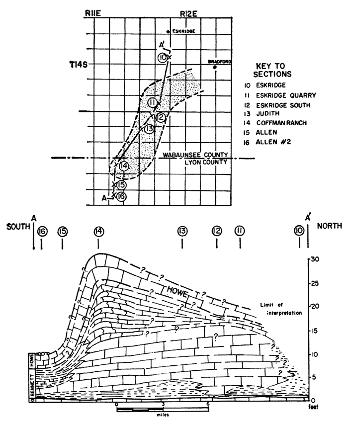
Figure 1 shows the outcrop belt and locations of key sections that were measured and sampled for this report. Detailed descriptions and illustrations of these sections appear in the Appendix. Figure 2, a simplified north-south cross section through localities shown on Figure 1, shows the fundamental correlations of rock units within the Red Eagle cyclothem.
Stratigraphic Relations
The gray shale and mudstone of the Johnson Shale are easily recognizable below the lowest fusulinid-bearing limestone (Glenrock) of the Red Eagle Limestone, and above the upper (Long Creek) limestone member of the Foraker Limestone.
Near Manhattan, Kansas, the Red Eagle Limestone is a kind of "sandwich"--the gray Bennett Shale Member lies between the Glenrock Limestone Member, below, and the pelletoid Howe Limestone Member, above.
The Glenrock Member is commonly a single, massive, light-brown limestone unit about 1 foot thick, containing abundant fusulinid remains. Its uniformity of thickness and lithology through 150 miles of outcrop from Lincoln, Nebraska, to Allen, Kansas, is truly remarkable. South of this area the fusulinid-bearing Glenrock is thinner or absent.
The Bennett Member can be readily recognized by its basal black Orbiculoidea-bearing shale that rests on the distinctive Glenrock Limestone. The gray shale and light-cream-gray limestone may also be identified by virtue of their relation to the overlying, equally distinctive Howe Limestone.
The Howe Member is a massive limestone unit commonly 2 or 3 feet thick. North of Manhattan much of the unweathered rock is aphanitic. In a number of localities south of Manhattan it is distinctively pelletoid (pseudo-oolitic). The pellets are coatings of calcium carbonate around tiny nuclei such as foraminifers or ostracodes.
The Roca Shale is easily identifiable by its position above the Howe Limestone. The top of the Roca is equally clear at the base of the overlying Sallyards Limestone (lowest member of the Grenola Limestone). The Sallyards Limestone is a thin, light-gray-brown unit crowded with well-preserved pelecypods (e.g., Pseudomonotis, Aviculopecten). Red shale is common in the midst of the principal gray and greenish-gray shale of the Roca Shale.
The three members of the Red Eagle "sandwich" of northern Kansas merge to form the single Red Eagle Limestone of southern Kansas and northern Oklahoma. This merging occurs because the Bennett Member is shaly in northern Kansas and changes to limestone in the south. Throughout the area studied the Johnson and Roca Shales are readily recognizable by their relations to the Red Eagle Limestone and to distinctive marker horizons above and below. Near Burbank, Oklahoma, the lower half of the Roca Shale is mostly red.
Rocks of the Red Eagle cyclothem can be detected and traced in wells as far west as central Kansas, where their general stratigraphic relations seem similar to those in the outcrop belt. The thin Bennett Shale, however, is not clearly recognized in the subsurface. Subsurface sections seem similar to outcropping sections. Lee (1949) has shown that the thicknesses and major lithic types of the Johnson, Red Eagle, and Roca in southern and central Kansas are generally similar to those in the outcrop belt 100 miles to the east. Lee's data, taken with observations made in this study, lead to the conclusion that in the southeastern quadrant of Kansas, major facies patterns of the Red Eagle cyclothem developed in roughly east-west belts. Well data also reveal the presence of gray and red shale in the Roca and gray shale in the Johnson parts of the column. Traces of selenite seem to be present near the redbeds in the subsurface Roca.
The locations of sections mentioned in the following pages are shown in Figure 1 and listed in Table 2.
Table 2.--Observed outcrops of the Red Eagle cyclothem.
| Locality | Section | Township | Range | County |
|---|---|---|---|---|
| Nebraska | ||||
| Bennet | NE 11 | 8 N | 8 E | Lancaster |
| Glen Rock | NW SW 30 | 6 N | 14 E | Nemaha |
| Johnson | NW NE 6 | 5 N | 13 E | Nemaha |
| Tecumseh | NE 33 | 5 N | 10 E | Johnson |
| Howe | NE 15 | 4 N | 14 E | Nemaha |
| Pawnee North | NW 26 | 2 N | 10 E | Pawnee |
| Pawnee | C NW NW 11 | 1 N | 10 E | Pawnee |
| Pawnee South | SW 23 | 1 N | 10 E | Pawnee |
| Richardson East | NW 19 | 1 N | 14 E | Richardson |
| Richardson West | SW 27 | 1 N | 13 E | Richardson |
| Humboldt | SE SE 16 | 1 N | 13 E | Richardson |
| Kansas | ||||
| Frankfort | NE NW 21 | 4 S | 9 E | Marshall |
| Manhattan | NE 7 | 10 S | 9 E | Riley |
| Manhattan East | CNL 20 | 10 S | 8 E | Riley |
| Manhattan West | NW NE 24 | 10 S | 7 E | Riley |
| Paxico | SW 30 | 30 S | 12 E | Wabaunsee |
| Alma | SW NE 11 | 12 S | 10 E | Wabaunsee |
| Keene | SE 24 | 13 S | 12 E | Wabaunsee |
| Eskridge | SE NE 17 | 14 S | 12 E | Wabaunsee |
| Eskridge Quarry | NW 32 | 14 S | 12 E | Wabaunsee |
| Eskridge South | NE 6 | 15 S | 12 E | Wabaunsee |
| Judith | NW NW 7 | 15 S | 12 E | Wabaunsee |
| Coffman Ranch | S/2 NW 23 | 15 S | 1 E | Lyon |
| Allen | NW SW 36 | 15 S | 11 E | Lyon |
| Allen No. 2 | SW NW 35 | 15 S | 11 E | Lyon |
| Dunlap | SE SE 23 | 17 S | 9 E | Morris |
| Saffordville | NW SW 30 | 19 S | 9 E | Chase |
| Elmdale | C 26 | 19 S | 7 E | Chase |
| Turnpike (mile 118.1) | 17 | 20 S | 10 E | Lyon |
| Sallyards | SW NW 11 | 26 S | 8 E | Greenwood |
| Piedmont | NE SW 30 | 27 S | 8 E | Greenwood |
| Grand Summit | SE 3 | 31 S | 8 E | Elk |
| Highway 38 | S line 21 | 32 S | 8 E | Cowley |
| Oklahoma | ||||
| Red Eagle | SW SE 25 | 28 N | 6 E | Osage |
| Burbank | C 25 | 26 N | 5 E | Osage |
Johnson Shale
The Johnson Shale was named by Condra (1927, p. 86), "From exposures 1 1/2 miles north of Johnson, Johnson County, Nebraska; formed of bluish argillaceous shale modified by thin, grayish, sandy layers, calcareous plates, and some gypsiferous material, and geodes; thickness 16 to 18 feet. There are very few fossils."
The Johnson Shale formation is still well exposed in a creek bank north of Johnson, Nebraska, approximately where Condra indicated. However, Johnson is in Nemaha (not Johnson) County, Nebraska. This location is east of the axis of the Table Rock (Nemaha) Arch (Fig. 1).
At the type locality (Johnson section; see Appendix) the base of the Johnson Shale is difficult to ascertain. The Long Creek Limestone below is badly disintegrated and weathered to a rusty to greenish, limonitic, chalky, soft residuum. In parts of Kansas the Long Creek Limestone is more resistant and clearly defined.
The Johnson Shale is approximately 17 feet thick at the type locality, where it is composed mainly of medium- to light-gray mudstone. The upper 1.5 feet comprises medium-gray, moderately laminated, very calcareous (50 percent), slightly silty shale that weathers to light buff. Some of this shale seems to be vaguely ripple marked. Laboratory examination revealed that it contains fish teeth, ostracodes, and small gastropods.
A thin, light-brownish-gray, argillaceous limestone underlies the upper, fossil-bearing shale. In the field this limestone appears aphanitic, but actually it is a laminated argillaceous calcisiltite having a few angular calcareous mudstone fragments. It exhibits vague, small-scale diastems and graded bedding. Fragments of carbonized woody plant detritus are present in the light-greenish-gray mudstone that immediately underlies this limestone.
At the type locality the remainder of the Johnson Shale, down to its base, is mainly greenish-gray calcareous mudstone. In the lower half of the formation the mudstone is slightly less calcareous than in the upper half. A thin plate of light-brownish-gray, dense, argillaceous limestone occurs just below the middle of the formation, but below it the only "limestone" present is sparse calcium carbonate nodules within the greenish-gray calcareous mudstone.
The northernmost exposure, near Bennet, Nebraska, is about 25 miles northwest of the axis of the Table Rock (Nemaha) Arch. The Johnson Shale is nearly 16 feet thick at the Bennet section (Appendix). The upper 2 feet of medium-gray, well-laminated shale is apparently equivalent to the upper 1.5 feet of moderately laminated shale at the type section. This shale is barren of fossils and much less calcareous (15 percent) than its equivalent at the type section. The rest of the formation consists almost entirely of moderately laminated, calcareous light-gray shale, the lower half of which is somewhat more calcareous than the upper--the reverse of the conditions at the type section.
A thin (0.5-foot) red shale, which seems to have no red equivalent elsewhere, appears in the middle of the Johnson Shale at the Bennet section. This is taken as the lower boundary of the Red Eagle cyclothem (Elias, 1937). Shale with limestone lenses near the base of the Bennet section seems equivalent to the mudstone with limestone nodules near the base of the type Johnson section. Traces of foraminifers, gastropods, and fish teeth occur about 5 feet from the base of the Bennet section.
To the south, in Pawnee County, Nebraska, 6 miles west of the Table Rock (Nemaha) Arch axis (Pawnee section; see Appendix), the Johnson Shale is composed mainly of mudstone very similar to that at the type locality. A few fragments of carbonaceous plant remains occur in thin, shaly, medium-gray mudstone in the top foot of the unit. This fine-silty mudstone also contains traces of ostracodes, a few clay-filled tubes suggesting worm burrows, and local mudstone-pebble breccia (some pebbles are oriented roughly parallel to bedding planes). The rest of the formation is virtually unfossiliferous.
A compact, laminated siltstone or mudstone unit (microbrecciated in places) appears near the top of the Johnson Shale at Pawnee. Textures vary microscopically from one lamina to another. This unit yields platy debris and, for convenience in the following descriptions, is called platestone. Commonly this unit is calcareous.
The remainder of the formation at the Pawnee section consists mainly of gray and greenish-gray mudstone and calcareous muddy siltstone. This sequence is interrupted only by a massive, 1-foot argillaceous limestone, vaguely nodular in some places, which occurs about 2 feet below the platestone. Megascopically this limestone appears uniformly aphanitic. However, magnified peel prints reveal that it contains minute wavy laminations associated with microscopic graded textures, suggesting slight diastems.
About 20 miles east of the Pawnee section, 0.5 mile east of the Humboldt Fault, the upper part of the Johnson Shale is exposed in a small road cut (Humboldt section; see Appendix). The upper Johnson argillaceous sediments resemble those at the Pawnee section in general appearance. In carbonate content they resemble the upper Johnson at the type section. The thin uppermost shale unit of the Johnson Shale at the Humboldt section correlates with shale in analogous position at the other Nebraska sections. At Humboldt, however, this upper shale is deeply weathered from its original gray color to a light yellowish gray-brown.
The Frankfort section (Appendix) lies just west of the axis of the Nemaha Anticline, about 30 miles south of the Pawnee section. Only the upper part of the Johnson Shale is exposed at Frankfort--sufficient to show the same clay shale at the top and a thinner, more compact platestone unit than is developed farther north. Ostracodes occur in shale between these units. Here the platestone is a limestone, thinly laminated, yielding platy debris much more brittle than the more argillaceous equivalents to the north. The bulk of the Johnson Shale at Frankfort consists of calcareous, light-gray and greenish-gray shale and mudstone typical of the Johnson Shale elsewhere.
At the Manhattan section (Appendix) the Johnson Shale consists largely of light-gray shale, with some light-greenish-gray shale in the lower half. The section is slightly thicker (17.8 feet) here than in Nebraska, where other complete sections (15-16 feet) of Johnson Shale are exposed. The distinctive platestone horizon occurs about 4 feet below the top of the formation, although nearby it is only 2 feet below the top. Above it is the usual ostracode-bearing light-gray shale, topped by a foot of well-laminated shale containing traces of crinoid, echinoid, bryozoan, brachiopod, and ostracode remains. This uppermost shale correlates with beds similar in position and lithology farther south. Beneath the platestone unit, the medial few feet of the formation contains light-buff to gray argillaceous limestone and very calcareous light-gray shale. greenish-gray and gray slightly calcareous shale makes up the lower one-third of the formation. The base rests on resistant Long Creek Limestone. The Manhattan section lies just west of the crest of the Nemaha Anticline.
The Alma section (Appendix) is 20 miles southeast of Manhattan and east of the Nemaha Anticline. At this locality only a few feet of the Johnson Shale are sufficiently exposed to permit reliable sampling. The familiar platestone occurs here, overlain by the equally familiar ostracode-bearing gray shale of the uppermost Johnson. Slumping confuses supradjacent beds, but the fossils indicate that the sampled shale is nearly equivalent to the topmost Johnson Shale. However, the local absence of the Glenrock Limestone precludes definitive measurement to the top of the Johnson.
The upper part of the Johnson Shale is well exposed at the Paxico section (Appendix). Three feet of typical gray, well-laminated, ostracode-bearing shale tops the formation and rests on 4 feet of calcareous mudstone and shale, which in turn rests on the platestone. Thus, at the Paxico section there is about twice the usual thickness of Johnson sediments above the platestone horizon. Moreover, the platestone is comparatively even textured and much less argillaceous than at other sections. Light-greenish-gray mudstone lies beneath the platestone.
At the Keene section (Appendix), 10 miles southeast of Paxico, only the platestone part of the Johnson Shale is well exposed. Here the platestone is well laminated and has the typical microscopically graded textures. The low content of insoluble mud in platestone at Keene is similar to that of the platestone at Paxico. About 5 feet of upper Johnson shale? above the platestone is not exposed.
The Eskridge section (Appendix) provides the southernmost exposure of the platestone facies of the Johnson Shale in Wabaunsee County. The platestone is faintly ripple marked and shows channeling as deep as 2 mm. About 3 feet of ostracode-bearing shale lies above the platestone. Light-gray and greenish-gray calcareous mudstone and shale typical of the Johnson Shale lie below. Beds below the platestone are similar to their equivalents in Nebraska and northern Kansas, except that rare traces of ostracodes and carbonaceous remains occur in the upper 2 or 3 feet. Charophytes are present near the base of the exposure.
At the Eskridge South section (Appendix), 4 miles south of the Eskridge locality, the upper half of the Johnson Shale is partly exposed in a farmyard. Dark-gray, calcareous, ostracode-bearing shale, some with plant remains, forms the upper 5 feet of the exposure. This rests on muddy limestone, possibly equivalent to the platestone horizon. The lower part of the exposure contains greenish-gray shale below a thin, local, argillaceous limestone that contains traces of ostracodes.
The few feet of upper Johnson sediments exposed at the Coffman Ranch section (Appendix) are similar to those at Eskridge South. Ostracodes and carbonaceous plant remains are rare to common in the upper 4 feet of calcareous shale. Traces of carbonaceous remains are visible in the underlying laminated muddy limestone.
At the Allen section (Appendix) carbonaceous remains and ostracodes are rare to common in the upper shale of the Johnson Shale. These beds rest on vaguely laminated muddy limestone and limy mudstone which are very similar to the stratigraphic equivalents at the nearby Coffman Ranch locality.
About 40 miles southwest of Allen, at the Elmdale section (Appendix), the upper two-thirds of the Johnson Shale is well exposed. Here, too, plants and ostracodes are present in the uppermost shale. Approximately 2.5 feet from the top, a laminated platy argillaceous limestone unit, faintly ripple marked, is the apparent equivalent of the platestone farther north in Kansas. Some of the laminations are extremely smooth and even. Greenish-gray mudstone, increasingly calcareous towards the base, makes up the remainder of the Johnson Formation.
At the Saffordville section (Appendix), 12 miles east of Elmdale, only platy limestone, bearing ostracodes, is exposed below the Red Eagle Formation. This appears to be the southernmost observable development of Johnson platestone facies.
In southern Kansas, at the Grand Summit section (Appendix), the upper half of the Johnson Shale is well exposed. The uppermost 5 feet is light-brownish-gray and medium-gray, calcareous, well-laminated shale containing light-gray aphanitic limestone nodules and lenticles. The shale contains gastropods, ostracodes, brachiopods, and carbonized fragmental plant material. Among the brachiopods, Linoproductus, Chonetes, and Productella? are common. Gastropod and brachiopod fragments occur in the limestone. Calcareous mudstone and shale constitute most of the remainder of the Johnson Shale at Grand Summit.
At the Highway 38 section (Appendix) in Cowley County, the upper half of the Johnson Shale is similar to that at the Grand Summit locality. Here, in the upper 5 feet, similar shale with nodular limestone contains the same assemblage of ostracodes, plant remains, and common productid brachiopods observable at Grand Summit. A thin maroon mudstone occurs about 16 feet below the top of the Johnson Shale. This is taken as the base of the Red Eagle cyclothem. No good exposures of Johnson Shale are known south of Highway 38.
Summary--The Johnson Shale is composed mainly of light-gray shale and mudstone immediately below the distinctive Red Eagle Limestone. In Nebraska it is at least 15 feet thick, and it thickens to 25 feet southward in Kansas. Workable exposures are rare. In most places, especially in southern Kansas and northern Oklahoma, it forms gentle grass-covered slopes between thin limestone benches. Maroon mudstone has been observed in the lower half of the formation only at the Oklahoma-Kansas border, in southern Kansas, and at Bennet, Nebraska. In southern Kansas the upper 5 feet of the Johnson Shale consists of fossiliferous shale containing aphanitic limestone nodules and lenticles. From central Kansas to the Nebraska border, the upper few feet of the Johnson Shale consists of laminated gray shale with ostracodes and carbonized plant remains. (The plant remains are rare in Nebraska.) In the same area the laminated shale is underlain by a horizon characterized by laminated muddy limestone yielding platy debris. In some places the purer, platy, brittle limestone may be conveniently called platestone. The platy horizon is identifiable from a few miles north of the Nebraska-Kansas border southward to Saffordville, Kansas. Shale in the lower half of the formation is almost invariably unfossiliferous.
Red Eagle Limestone
The Red Eagle Limestone was named by Heald (1916, p. 24-25) from "excellent" exposures near Red Eagle School, about 3 miles west of Foraker, Osage County, Oklahoma. Heald referred to these exposures as "... a number of distinct beds of limestone, between which are beds of shale in some localities." The Red Eagle School mentioned by Heald was destroyed many years ago, and the limestone exposures in that neighborhood (Red Eagle section; see Appendix) represent only a part of the total thickness.
The best exposures of the Red Eagle Limestone in the type area are in the large quarry immediately north of U.S. Highway 60, just east of Burbank, Osage County, Oklahoma (Burbank section; see Appendix). This is the southernmost locality sampled for this investigation.
The Burbank section exposes approximately 21 feet of limestone beds. The Red Eagle base is buried. In the lower 6 feet of the exposed interval, brownish-gray, aphanitic to microcrystalline, medium- to thin-bedded limestone grades laterally into similar but shaly laminated limestone. Somewhat wavy, laminated, calcareous shaly interbeds are characteristic of this part of the sequence. These limestone beds contain rare to common productid brachiopod fragments, crinoid columnals, and ostracodes, all oriented roughly parallel to bedding planes. Three feet of hard, dense, massive, medium- to thick-bedded, light-brownish-gray limestone rests on the aforementioned shaly limestone. Rare to common crinoid columnals and rare brachiopod and ramose bryozoan remains are present in the dense microcrystalline matrix. Stringers of shaly calcareous material and calcareous shale intergrade laterally with this limestone. Shaly interbeds up to 0.5 inch thick emphasize the thick, resistant limestone beds. Eight feet of light- to medium-greenish-gray, argillaceous, medium-bedded limestone overlies the massive, brownish-gray, microcrystalline limestone. The greenish-gray color accompanies a greater (10 to 15 percent more) clay content than that in the lower brownish limestone. Crinoid discs and brachiopod fragments are rare to common in the aphanitic argillaceous matrix. Some beds are vaguely laminated and argilaceous enough to appear shaly when deeply weathered.
The strata just described from the Burbank section total about 17 feet in thickness. Their lithologies, bedding, and faunal content indicate that they represent a facies of the Bennett Member of the Red Eagle Limestone. The more massive, resistant parts of this Bennett Member form subdued topographic benches in northern Oklahoma and southern Kansas.
At the Burbank section 4 feet of irregularly bedded limestone, resting on the limestone of the Bennett Member, is distinctive--thickly to thinly bedded, pitted, rusty weathering, and penetrated by brick-red clay and clayey limestone stringers and tubes. Traces of crinoids, brachiopod fragments, and arenaceous foraminifers are present. Nothing quite like these beds is known in Kansas. They are tentatively correlated as equivalents of the Howe Member of the Red Eagle Limestone, mostly because of their position below Roca red shale and above probable Bennett limestone. No equivalents of the Glenrock Member of the Red Eagle Limestone have been recognized in Oklahoma.
South of the Burbank area the Red Eagle Limestone is poorly and only partly exposed. The resistant portions of the Bennett Member thin southward in Osage County, Oklahoma, and can be traced to the Arkansas River west of Fairfax, where Fisher (1956, p. 83) noted a thickness of 1.9 feet of Red Eagle Limestone within a 125-foot covered interval.
In the Foraker area, at the Red Eagle section (Appendix), about 1.5 miles east-southeast of Heald's type locality, the massive limestone of the middle of the Bennett Member forms a minor hillside bench. This can be traced northward into Kansas and southward beyond Burbank, Oklahoma. Depending upon the proportion of the less resistant argillaceous limestone, the ledge-forming limestone of the Bennett Member ranges in thickness from 3 to 6 or more feet. The Red Eagle section reveals 5 feet of massive, thick-bedded, light-brownish-gray, somewhat vuggy, pure limestone. The assemblage of bryozoans, arenaceous foraminifers, crinoids, and brachiopod fragments suggests that these beds are equivalent to the medial, nearly pure, resistant limestone unit of the Bennett Member at the Burbank section. In the Foraker (Red Eagle section) area of northern Oklahoma, the Howe Member equivalent does not seem to resist weathering any better than the softest of the Bennett limestone beds. The Howe is detectable in the Foraker area only from rare slabs of limestone float (similar to Burbank "Howe") in covered intervals just above the resistant Bennett limestone.
In southern Kansas, at the Highway 38 section (Appendix), the members of the Red Eagle Limestone are all definitely recognizable. The Glenrock Member disappears somewhere south of Highway 38, probably near the state line. Northward from Highway 38, the Glenrock, Bennett, and Howe Members of the Red Eagle Limestone are traceable through facies changes to and beyond their type localities in southeastern Nebraska. The Elmdale, Saffordville, and Alma localities (Appendix), where the Glenrock Member is not recognized, are somewhat anomalous. Facies changes within the members of the Red Eagle Limestone formation are discussed below.
Glenrock Limestone Member
The Glenrock Limestone Member of the Red Eagle Limestone was named by Condra (1927, p. 86) "...from exposures high in the valleyside just northwest of Glenrock, Nemaha County, Nebraska; dark gray, dense, weathering light gray or slightly buff; thickness 1 to 2 feet. This forms rectangular blocks. The leading fossils are Fusulina, bryozoa, brachiopods, and Pinna sp."
At its type locality near Glen Rock, Nebraska, the Glenrock Member forms an inconspicuous ledge cropping out on long, gentle, grassy slopes which hide the shale above and below. [Note: The spelling "Glenrock" for the rock unit is retained for reasons discussed by Moore (1952).] Upper and lower contacts are not visible. The unit may be sampled best from rare blocks displaced by road building, or in ditch cuts. The type GIenrock Member is a light-brownish-gray fusulinid-bearing limestone, 1 foot thick. It weathers to light gray. Common fusulinids (Triticites sp.), brachiopods, and ostracode fragments repose in a microcrystalline to aphanitic calcareous matrix containing only 10 percent insoluble clays. The rock is hard and even textured, and it presents an oatmealy appearance on fresh surfaces. Fusulinids here are slightly smaller than in other exposures of the Glenrock Member.
O'Connor and Jewett (1952, p. 343) asserted that "the Glenrock limestone can be divided into two faunal and lithologic parts: (1) fusulinid-bearing rock above, and (2) a nonfusulinid part at the base" and that "in a few places one or the other is not present or is poorly developed." This is an accurate appraisal of what field reconnaissance reveals. Detailed studies show that the lower portion of the Glenrock Member is not everywhere "nonfusulinid," although its fusulinid content is commonly sparse. Where this twofold character of the Glenrock Limestone is manifest, the fusulinid-bearing rock grades into "nonfusulinid" rock with no perceptible break.
At the Bennet section (Appendix) the Glenrock Limestone is a massive, ledge-forming unit 1.5 feet thick. The upper 0.5 foot of this rock contains numerous fusulinids, but the lower 1 foot contains none. Brachiopods, other foraminifers, and ostracodes are common where fusulinids are absent. Faint traces of linear algae occur in this lower portion. The calcareous microcrystalline matrix for fusulinids and other fossil detritus contains less than 10 percent insoluble clay. The upper foot of the unit has a few random patches of muddy limestone somewhat similar to the overlying shale of the Bennett Member. Fusulinids in this part of the GIenrock Member show some tendency toward orientation parallel to the bedding. Vague, wavy, clay-limestone seams, much fainter than the subtlest diastem, share the vague preferential orientation. The lower 0.5 foot of the member is practically structureless and even textured. The Glenrock Limestone weathers light gray. The lower contact of the Glenrock is gently undulatory, and the Glenrock rests on the shale of the uppermost Johnson Shale with only slight evidence of erosion. The upper contact is also slightly undulatory beneath dark-gray Orbiculoidea-bearing Bennett Shale. These contacts are unusually clear and sharp.
At the Johnson section (Appendix) the Glenrock Limestone is 1 foot thick and resembles its equivalent at the type section. The upper 0.9 foot contains abundant fusulinids and rare to common brachiopod detritus. The basal 0.1 foot of the unit consists of hard, dense, aphanitic to microgranular limestone which lacks fusulinids. The upper and lower contacts are weakly undulatory and typically sharp.
The Pawnee section (Appendix) exposes a distinctive development of Glenrock Limestone. The thickness ranges from 0.7 to 1.0 foot. Fusulinids abound in the upper half of the unit, along with common frail brachiopod fragments and rare gastropods. The lower half lacks fusuIinids and gastropods but contains common brachiopod fragments. Acetate peel prints reveal that many of these brachiopod fragments are coated with secondary calcite, similar to the alga Osagia. The partly bioclastic calcareous matrix for the detrital material is aphanitic to microgranular and somewhat argillaceous.
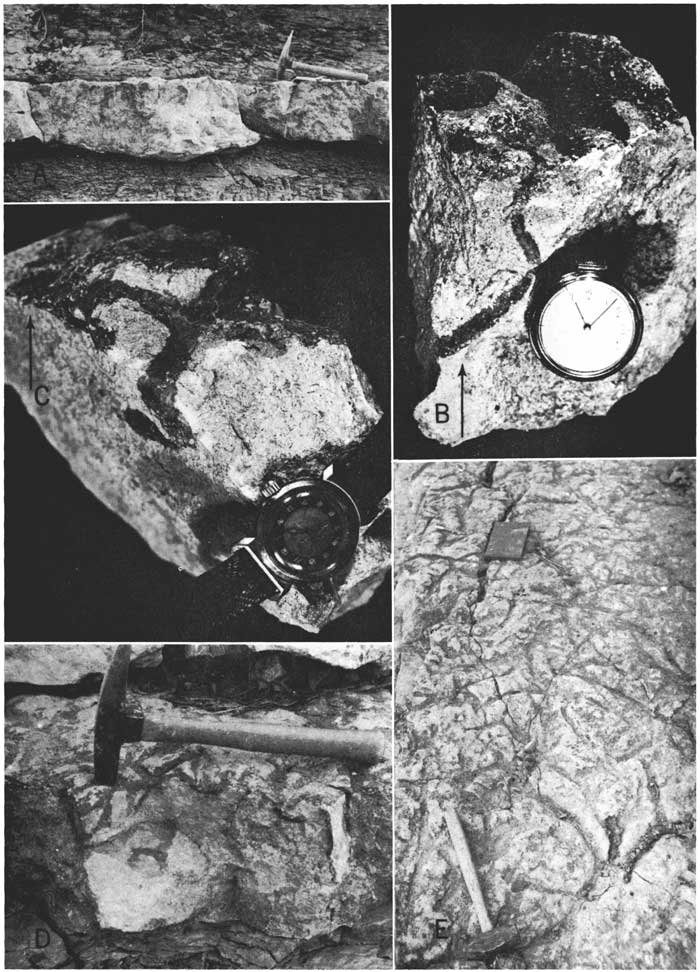
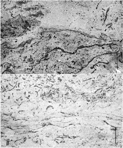
The base of the unit is gently undulatory (Pl. 1A) and locally rests on small lenses, an inch or two thick, of buff aphanitic limestone containing brachiopod fragments. The upper limit is even more distinctive than the gently undulatory base. It is undulatory, or lumpy and channeled, but on a small scale (1-inch relief). The pattern of lumps and channels suggests that the top of the limestone is traversed at random by depressions representing the trails of benthonic animals (Pl. 1E). The shale of the overlying Bennett Member is impressed into these trails and, surprisingly, contains fusulinids. The top few inches of the limestone is randomly penetrated by tubes (worm burrows) filled with black muddy matcrial (Pl. 1B, 1C, 1D) continuous with the black shale of the basal Bennett Member. Some of these black tubes also contain fusulinids and Osagia-coated shell detritus.
Plate 1.--Glenrock Limestone at Pawnee section. A, Undulatory base; B and C, uppermost limestone showing black tubes interpreted as worm burrows; D, closeup showing worm burrows on outcrop (below face of hammer); E, channels and trails in top of Glenrock. Arrows point to top of bed.
In southwestern Richardson County, Nebraska, atop the Nemaha Anticline, the Glenrock Limestone is well exposed at the Humboldt section (Appendix). Here, also, the base of the unit is undulatory, with relief of about 0.1 foot. The upper contact is almost flat. As usual, fusulinids abound, along with many brachiopod fragments, in a microcrystalline to very finely granular (aphanitic) calcareous matrix. Most of these fossils are oriented crudely parallel to the bedding. Some of the brachiopods are coated by calcareous deposits which suggest Osagia or other algae. There is also some evidence of linear algae. Articulate brachiopod shells are present but scarce. They are filled with calcarenaceous bioclastic detritus in a microcrystalline, clear calcitic matrix. Locally the rock is medium grayish brown on fresh surfaces, but it weathers to medium rusty brown rather than the light gray typical of most weathered Glenrock Limestone. It forms an indistinct ledge, 1 foot thick, in the grassy hillsides of the area.
The Glenrock Member is thicker (1.8 feet) than average at the Frankfort section. Fusulinids are extremely rare in the lower 0.5 foot of the unit but gradually increase in number upward. Where fusulinids are scarce, brachiopods are quite common. The upper 0.5 foot of the GIenrock Limestone contains abundant fusullnids and scarce brachiopods, which include Composita sp. and productids. Not all shell detritus is broken. Traces of articulated brachiopod shells are visible in polished rock sections. A few ostracodes and uncrushed gastropods accompany the brachiopod detritus. A few of the frail brachiopod fragments are coated by calcareous algal deposits similar to Osagia. The organic detritus in the fusulinid-rich limestone is not visibly sorted. In the lower portion of the unit a patchy sorting is common where some textural patterns vaguely extend parallel to bedding and some brachiopod shell detritus is similarly aligned.
At the Manhattan section (Appendix) the GIenrock Member (1.3 feet thick) is superficially normal, but close examination reveals a distinctive local lithology. The Glenrock Member comprises fine conglomeratic, calcirudaceous, medium- to light-brownish-gray limestone. Randonily oriented granules and small pebbles of aphanitic, greenish-gray to buff, argillaccous limestone are bound by a calcarenaceous to calcaphanitic limy matrix containing many brachiopod shells. Most of these shells are coated by calcareous deposits similar to Osagia, and some show crude preferential orientation pirallel to bedding. Ostracodes and gastropods are also present in the matrix. The rock lacks fusulinids. Upper and lower contacts are relatively even and clearly defined.
At the Paxico section (Appendix) the lithology of the GIenrock Limestone is intermedlate between the nonfusulinid material found locally at the Manhattan section and the widespread, fusulinid-rich rock found elsewhere. Aphanitic buff limestone granules occur in the calcisiltaceous to calcaphanitic light-creamy-gray matrix of the lower part of the unit. Fusulinids are rare and the limestone granules are scarce in the similar but medium-brownsh-gray matrix of the upper limestone. A few brachiopod fragments and spines, ostracodes, bryozoans, and small gastropods occur randomly throughout the unit. The upper and lower contacts are even and distinct.
The GIenrock Limestone Member is apparently absent from the Alma section (Appendix) area. This observation was first made by O'Connor and Jewett (1952, p. 350). Shale of the Bennett Member of the Red Eagle Limestone probably rests paraconformably on upper shale of the Johnson Shale. Moreover, poor exposures make it impossible to determine whether the Glenrock is the only missing part of the Red Eagle Limestone formation. Such absence might be the result of nondeposition. O'Connor and Jewett ( 1952, p. 343) placed the base of the Red Eagle Limestone "at the contact between the black or dark-gray shale beds and the gray-green or gray limy beds of the Johnson." Actually, this dark-gray shale contains ostracodes and carbonaceous remains characteristic of uppermost Johnson elsewhere. Hence the contact must be slightly higher in the Alma section than the lithologic level noted by O'Connor and Jewett. Precisely how much higher could not be ascertained because of unsatisfactory exposures.
About 13 miles southeast of Alma and Paxico, at the Keene section, the Glenrock Member is a normal-appearing, 1-foot, light-brownish-gray, calcarenaceous, fusulinid-bearing limestone. Traces of Osagia-coated shell fragments occur with the fusulinids. The base of the unit is even. The upper contact, partley obscured by weathering, is somewhat lumpy and resembles the one at the Pawnee section. In some parts of the outcrop, the top inch of Genrock Limestone is argillaceous, lacks fusulinids, and is medium-gray, as though heralding a complete change to Bennett black shale at the top contact. Traces of Orbiculoidea fragments are present in a few places within the top half inch.
At the Eskridge section (Appendix) the Glenrock is the usual fusulinid-baring light-brownish-gray limestone about 1 foot thick. Traces of argillaccous material bearing Orbiculoidea fragments are present in the uppermost 1 inch. Upper and lower contacts are distinct, but weathering has obscured the upper contact in some places. The top fusulinid-rich inch, which contains Orbiculoidea fragments, shows evidence of burrowing and resettling from the Bennett Member above. Traces of millky, secondary opaline silica are present in the top inch of the unit.
The GIenrock Member at the Judith section (Appendix) is very simllar to that it the Eskridge section, but the upper contact has not been weathered. Fusulinids abound, along with many brachiopods and a few ostracodes and smaller foraminifers, in the calcarenaceous to calcaphanitic matrix. The top is gradational to the Bennett Member above through half an inch of shaly argillaceous limestone. This thin limestone contains numerous Orbiculoidea, traces of Lingula, and traces of fish teeth. The lower contact is buried.
At Eskridge South (Appendix) the GIenrock Limestone lithology is almost the same as at the Judith section, except that the upper half inch contains patches of dark-gray, argillaceous material. The top is lumpy and gently undulatory (0.05-foot relief) and displays random patches of fusulinid coquina with traces of Orbiculoidea and fragments of bryozoans.
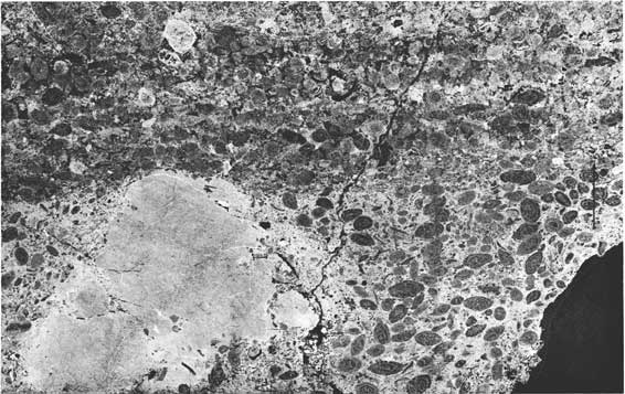
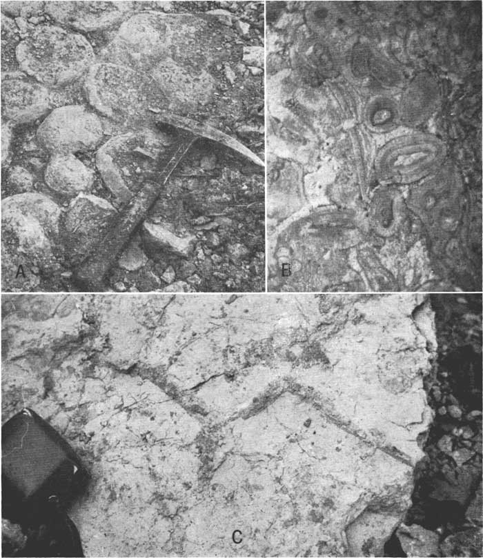
The section at Coffman Ranch (Appendix) shows the GIenrock Member as a medium-brownish-gray limestone, considerably thinner than at sections to the north. It resembles GIenrock lithofacies in southern Kansas and yet shows other features characteristic of Nebraska and northern Kansas facies. Its thickness ranges from about 0.2 to 0.4 foot within the 500-yard exposure. The base is gently undulatory through about 0.1 foot of section. Fusulinids, extremely abundant in the calcarenitic to calcaphanitic matrix, are accompanied by many or few brachiopods and small foraminifers. Many of the brachiopod fragments have coatings of algal calcium carbonate (Osagia?) but other fossils do not. Some parts of the rock are faintly congIomeratic, containing granules and pebbles of aphanitic argillaceous limestone or calcareous mudstone similar to but much less numerous than those at the Manhattan and Paxico sections. The pebbles are best represented in the otherwise normal fusulinid-bearing rock (Pl. 2) at and near the base of the GIenrock. The fragments at the base have lithology (and contain carbonaceous remains) similar to upper Johnson sediments. One such fragment is covered by Osgaia-like algal material. Locally, the upper part of the unit is penetrated by tubes of Orbiculoidea-bearing, medium- to dark-gray argillaceous material continuous with the Bennett Shale above. These are much like the tubes at the Elmdale and Pawnee sections (Pl. 1, 3). At the top, the GIenrock Limestone grades upward through 0.1 inch of rock, from a fusulinid subcoquina to an Orbiculoidea subcoquina continuous with the overlying black Orbiculoidea-bearing shale of the Bennett Member. That is, the top contact is typically sharp.
Plate 2.--Peel print (x3.0) of Glenrock Limestone from Coffman Ranch section. Note large aphanitic limestone pebble and slight preferential orientation of fusulinids parallel to bedding planes. Arrow points to top of bed. [Note: This image is scanned to be similar in size to that in the published book. A larger version is available to show more detail.]
At the Allen section (Appendix) the GIenrock Member is a light-brownish-gray ledge-forming limestone 1.3 feet thick. The upper half of the unit is crowded with fusulinids. Downward their number decreases, so that the lower one-third of the limestone is almost barren of fusulinids. Common aphanitic limestone granules and small pebbles similar to those at Manhattan are present in the medial part of the unit, where fusulinids are numerous (Pl. 4). Some of these algal? pebbles show shrinkage cracking. The pebbles are rarer and smaller in the lower part of the unit. A variety of fragmental fossil remains, most of which are brachiopods, along with a few tiny gastropods and ostracodes, occur amid the fusulinids and limestone granules. These fragments are more common where fusulinids are lacking. Many of the brachiopods are coated with deposits of calcium carboaate similar to Osagia. The matrix for the detritus is aphanitic to arenaceous, slightly argillaceous, calcium carbonate. The top contact of the Glenrock Member is gently undulatory, but the lower contact is even (Pl. 3).
Plate 3.--A, Contact of Johnson Shale and Bennett Member of Red Eagle Limestone at the Elmdale section. Hammer head is at contact. B, Sample of uppermost Johnson Shale from Elmdale section. Arrow points to top of bed. Note dark Orbiculoidea-bearing tubes near top. C, Lingula sp. in black basal Bennett Shale from Bennett section. D, Glenrock and Bennett Members of Red Eagle Limestone at Allen section. Observer's hand touching top of Glenrock; eye level at contact between lower shale and medial limestone facies of Bennett Member.
The GIenrock Limestone at Allen No. 2 section (Appendix) is similar to its equivalent at the Allen section. Fusulinids are abundant, and occur with many brachiopods and a few gastropods in the usual calcaphanitic to calcarenitic matrix. Granules of aphanitic limestone and algal-coated brachiopods are uncommon. Irregular tubes of gray argillaceous material containing Orbiculoidea (similar to those at the Pawnee and Coffman Ranch localities) penetrate the upper 2 inches of limestone. The base of the unit is quite distinct and even but the top is gently undulatory and sharply defined. A subcoquina (similar to the one at the Coffman Ranch section), 0.15 inch thick, of Orbiculoidea and Lingula fragments in a black argillaceous matrix continuous with the overlying Bennett Shale, is plastered upon the top of the GIenrock Limestone.
The Glenrock is not present at the Saffordville section (Appendix), where lower shale of the Bennett rests paraconformably on upper (not uppermost) Johnson Shale.
A peculiar lithofacies which could be mistaken for Glenrock is visible at the Elmdale section (Appendix) below Bennett black shale. It is about 1 foot of argillaccous, light-gray to brownish-gray, vaguely lamitiated and faintly cross-laminated limestone. Tubes of dark clayey material containing Orbiculoidea and fish teeth, and short burrows containing Glenrock-like fusulinid-bearing limestone, penetrate the upper 0.1 foot of the unit from the thin Bennett black shale above (Pl. 3B). A patchy coquina of Orbiculoidea lies at the base of the overlying shale. Because these lithologies and structures are similar to those in the uppermost GIenrock Limestone at the Pawnee, Coffman Ranch, and Allen sections, this unit might be mistaken for an argillaceous facies of the GIenrock Member. However, the top of the unit is clearly defined and somewhat undulatory, and the less distinct base grades to shale which contains plant remains and ostracodes typical of the upper part of the Johnson Shale. Moreover, the color of the unit, its softness, its microstructures, its insoluble clay content, and its fossils suggest that it is part of the Johnson Shale. Thus, the combined evidence seems to demonstrate that the Glenrock member is absent at the Elmdale section, probably because of erosion.
The GIenrock Limestone is about 1.5 feet thick at the Piedmont section (Appendix). It consists of thin beds of limestone bearing abundant fusulinids in a microcrystalline matrix. Upper and lower contacts cannot be described in detail because they are poorly exposed. Nodules and blebs of milky and medium-gray chert are randomly present in the limestone.
At the Grand Summit section (Appendix) the Glenrock Limestone is thin (0.25 foot) but readily recognizable. Fusulinids are abundant and brachiopods are rare in the usual aphanitic matrix. Traces of gastropods and crinoid discs are also evident. The contacts are gently undulatory. Some fresh surfaces show a few small, round, dark-gray argillaceous spots (containing rare tiny Orbiculoidea fragments) suggesting cross sections of worm burrows. The overlying shale of the Bennett contains abundant Orbiculoidea.
The Highway 38 section (Appendix) is the southernmost studied exposure of the fusulinid-bearing GIenrock Limestone. As at the Piedmont section, the GIenrock Member is thin (0.5 foot) and is identified as much by its relation to the overlying Orbiculoidea-bearing Bennett Shale as by its own distinctive fossils and lithology. At the Highway 38 locality, the Glenrock Limestone is softer and more argillaceous than its equivalents to the north, but it contains the same fusulinids. Some brachiopods and crinoid discs accompany the fusulinids. Rare wormy tubes of black clay penetrate the top 1 to 2 inches of the limestone. Upper and lower contacts gre gently undulatory.
Summary.--The Glenrock Limestone Member of the Red Eagle Limestone is commonly a fusulinid-bearing, medium- to light-brownish-gray limestone. Over much of its outcrop belt (north of Allen, Kansas) it is a single unit about 1 foot thick and locally resistant enough to support minor topographic benches. It is readily identifiable in the field by its lithologic characteristics and by its position beneath black Orbiculoidea-bearing shale of the lower Bennett Member. In localities where the Bennett limestone facies is thick, the Glenrock Member is normally less than 0.5 foot thick. Where the GIenrock Member is absent, the position of the corresponding paraconformity can be closely approximated at the base of the Bennett Orbiculoidea-bearing black or gray shale where it lies directly on ostracode- and plant-bearing gray shale or platestone of the upper part of the Johnson Formation. The Glenrock Limestone commonly contains brachiopod fragments and spines, traces of gastropods and ostracodes, and profuse fusulinids set in a calcareous matrix. Much of the matrix is bioclastic calclum carbonate grading from calcarenaceous to calcilutaceous to microcrystalline.
Wormlike tubes arid ribbons of Orbiculoidea-bearing gray clay that are continuous with the basal shale of the Bennett penetrate the top ot the Glenrock at some localities. Osagia-like calcium carbonate coatings on brachiopod fragments are rare to common in the Glenrock Limestone, especially in Nebraska and northern Kansas.
The outstanding characteristic of the Glenrock Limestone is its uniformity of thickness and lithology between Bennet, Nebraska, and Allen, Kansas. Between Allen and Highway 38 the GIenrock Limestone is commonly less than 0.5 feet thick. No stratigraphic equivalent of the Glenrock Member is known in Oklahoma and southern Kansas south of Highway 38. It is probable that the Glenrock pinches or phases out in this area.
The fusulinid-bearing Glenrock Limestone, with black Orbiculoidea-bearing Bennett Shale resting directly upon it, is a reliable stratigraphic marker, recognizable and useful from Bennet, Nebraska, to southern Kansas.
Plate 4.--Peel print (x2.5) of Glenrock Limestone from Allen section. Note aphanitic limestone granules and aphanitic (algal?) lime coatings on shells near botton left of picture. Note shrinkage cracks in granules at bottom, left, and top center of picture. The long axes of many fusulinids are crudely oriented parallel to the bedding planes. Arrow points to top of bed. [Note: This image is scanned to be similar in size to that in the published book. A larger version is available to show more detail.]
Bennett Shale Member
The Bennett Shale Member of the Red Eagle Limestone was named by Condra (1927, p. 86) "... from exposures along the Little Nemaha and its branches South of Bennett, Lancaster County, Nebraska; formed of bluish gray and nearly black argillaceous shale, with one carbonaceous streak resembling coal and a thin yellowish to brownish limestone; combined thickness 5 to 11 feet.
Fauna: Orbiculoidea missouriensis, Lingula sp., Composita subtilita, Spirifer cameratus, and a few other species."
At the type section (Bennet* section; see Appendix) the Bennett Member is approximately 8 feet thick. [*Note that Condra misspelled the town name Bennet. The spelling "Bennett" is retained in stratigraphic nomenclature for reasons discussed by Moore (1952).] The lowermost 4 feet is slightly calcarcous gray shale and mudstone containing Orbiculoidea and an abundant microfauna. The basal shale is dark gray to black and contains abundant Orbiculoidea. Much of the black shale emits a fetid odor when treated with hydrochloric acid. A few frail specimins of Lingula (Pl. 3C) are associated with common Orbiculoidea just above the contact with the distinctive Glenrock Limestone. Equivalents of this basal Orbiculoidea-bearing black shale are an excellent stratigraphic marker traceable to southern Kansas. About 4 feet from its base, the Bennett Member includes a hard, light-brownish-gray, slightly argillaceous, microgranular limestone 1 foot thick. Above this limestone is another 3 feet of buff-colored calcareous shale and mudstone. These beds lack conodonts and orbiculoids, but some contain fish teeth and ostracodes. Three feet of masslve, hard, aphanitic, light-gray Howe Limestone rests on the tooth-bearing beds. The type locality is satisfactory for observation of the lower Bennett shale beds and their relations to the GIenrock Member, but for purposes of long-distance correlation the relations of upper Bennett to the overlying Howe Limestone are much more understandable if observed in central Kansas.
Only 5 feet of light- and medium-gray shale and mudstone containing Orbiculoidea and other brachiopod fragments is exposed at the Tecumsch section. These beds contain a characteristic Bennett microfauna of conodonts and fish teeth in the darker, less calcareous shale. Ostracodes and foraminifers are present in the calcareous shale and mudstone.
About 2 feet of basal Bennett dark-gray or black, well-laminated, Orbiculoidea-be-aring shale having abundant microfossils is exposed at the Johnson section (Appendix). The contact with the Glenrock Limestone is sharp and gently undulatory.
Excellent exposures of the Bennett Member are available at the Pawnee section (Appendix). The lower contact of the basal black shale is impressed into peculiar channels (Pl. 1B, 1C, 1E) and fills the tubes in the uppermost Glenrock Limestone. Some of the black shale within the channels and against the top of the Glenrock contains small, lumpy accumulations of crushed shells and carbonate rich in fusulinids. Individual free fusulinids are common on the upper surface of the GIenrock Limestone, where they are surrounded and covered by black Bennett clay. Lingula accompanies Orbiculoidea in the lowermost 0.25 inch of shale resting on the Glenrock Limestone.
The basal 4.5 feet of the Bennett Member at Pawnee consists of gray to very dark gray, almost black, slightly calcareous shale which contains a varied microfauna and few, but conspicuous, articulated brachiopod shells and spines oriented roughly parallel to bedding and fissilltv. Orbiculoidea is typical of the entire assemblage. The dark shale sequence grades upward through 1 foot of calcareous, buff siltstone and mudstone into the soft, pitted Howe Limestone.
The Bennett Member at the nearby Pawnee South section is quite similar to its equivalent at Pawnee, but its fauna is less abundant.
Only the basal 3 feet of the Bennett Member is exposed at the Humboldt section (Appendix), and this is the same as the dark-gray, well-laminated, Orbiculoidea-bearing shale at the type section. The unit is estimated to be about 5 feet thick in this area. A 0.25-inch horizon of Orbiculoidea coquina occurs near the base of the black shale. At the very base, where many of the shells are only slightly flattened, rare Lingula accompany the orbiculoids.
Only the basal 2 feet of the Bennett Shale is exposed at the Frankfort section. The beds are almost identical with the slightly calcareous black shale exposed at the Humboldt section, with the exception that a few ostracodes occur with the abundant Orbiculoidea at the base.
At the Manhattan section (Appendix) the Bennett Member is about 4 feet thick and well exposed. At the other exposures within the Manhattan metropolitan area, and at the Tuttle Creek dam a few miles north of Manhattan, the Bennett Shale is also about 4 feet thick. In these exposures, and at the sampled section, the Bennett Member is entirely shale. Orbiculoidea is rare in these beds but bryozoans and bracichiopods are common. The shale is well-laminated, calcareous, and waferlike.
The Bennett facies of the Paxico section (Appendix) differs from those of Nebraska and northern Kansas. More than 2 feet of the characteristic black fissile shale lies at the base, but the remaining 6 feet consist of brownish-gray, vaguely laminated, argillaceous limestone. Despite the different lithofacies, traces of Orbiculoidea and fish teeth are present from base to top of the member. Orbiculoidea coquina similar to the one at Humboldt is present along some laminae in the basal 0.5 foot of the black shale.
Exposures are so poor at the Alma section that they yield little information about the local characteristics of the Bennett The estimated thickness is qbout 19 feet. The uppermost Bennett beds, beneath the Howe Limestone, are argillaccous calcisiltites somewhat similar to beds in similar stratigraphic position at Paxico.
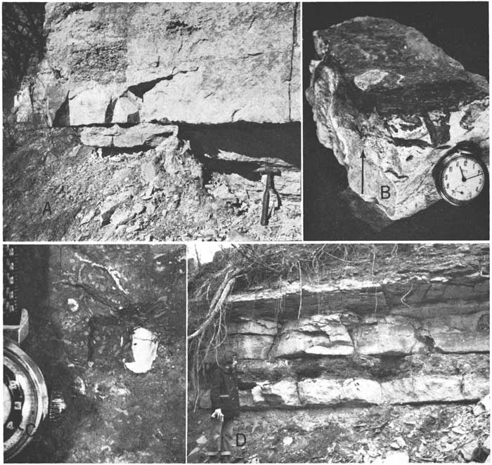
At the Eskridge section (Appendix) only the GIenrock Member is well exposed, but the Bennett is estimated to be about 6.5 feet thick and composed of shale. This local feature of the Bennett Member might be regarded as unimportant were it not for a thick limestone development in the Bennett close by. That is, within a distance of 3 miles, the Bennett changes from about 6.5 feet of topographically weak shale at the Eskridge section to about 3 feet of shale overlain by about 15 feet of medium-bedded resistant limestone and 3 feet of rubbly-bedded limestone at the Eskridge Quarry section (Appendix). Thus, the most abrupt lithofacies change in the Bennett Member is indicated.
Figure 3.--Diagrammatic cross section showing interpretion of thick Bennett limestone facies in Eskridge-Coffman Ranch area. Area of thick Bennett limestone facies is shown on location map (midified from Mudge abd Burton, 1959, pl. 9).
When quarrying is active, a complete section of the Bennett Member can be seen at the Eskridge Quarry. During suspension of quarry operations the excavations accumulate enough water to submerge the lower 7 feet of the Bennett Member. At such times these lower beds may be sampled at the nearby Judith section, where the Bennett facies is nearly the same as at the Quarry.
At the Eskridge Quarry and Judith sections the basal 3 feet of the Bennett Member consists of typical black Orbiculoidea-bearing shale. The lowermost bed also contains traces of Lingula and conodonts. Medium-bedded, and very light brownish-gray limestone more than 15 feet thick rests upon the shale. Orbiculoidea and fusulinids are present in the lower 1 to 2 feet of this Bennett limestone. Brachiopods, echinoid and brachiopod spines, crinoid discs, and foraminifers are rare to common in the aphanitic calcareous matrix which constitutes most of the rock. Laboratory analyses revealed that little of this limestone contains more thin 1 percent of insoluble clay residue. The sudden thickening and the purity of this limestone suggest that it might be a part of a Bennett reef facies.
The thickened limestone accumulation extends from the Eskridge Quarry through the Judith and Coffman Ranch areas, where it forms a conspicuous bench on the local grassy hillsides. Shallow sinkholes in the Bennett limestone are common topographic features of this Eskridge-Coffman Ranch area.
O'Connor and Jewett (1952) noted this Bennett lithefacies (Fig. 3) and called it a bioherm. The original definition of bioherm by Cumings (1932, p. 333) applies the term to "reeflike, moundlike, lenslike or otherwise circumscribed structures of strictly organic origin, embedded in rocks of different lithology." In broad outline the Bennett limestone of the Eskridge-Coffman Ranch area faintly resembles part of a bioherm or reef. However, internal characteristics of this limestone (e.g., bedding) certainly are not reeflike, nor can its "strictly" organic origin be verified, although much of the mass is obviously organic shell detritus and much may be of algal origin. Moreover, the Bennett limestone lithofacies of southern Kansas and Oklahoma is remarkably similar to that of the Eskridge-Coffman Ranch area, except that the southern lithofacies is too broadly distributcd and uniform in thickness to permit the slightest suggestion that it is biohermal or reeflike in form.
It must also be noted (Fig. 3) that whereas the western and northern margins of the Eskridge-Coffman Ranch area of Bennett limestone are bounded by shale ("rocks of different lithology"; Cumings, 1932) the southern edge of the thickened beds passes gradually into thinner beds of like composition, visible within the Bennett Member at the Allen, Elmdale, and Saffordville sections.
The words of Moore (1957, p. 1790) seem to describe perfectly these stratigraphic conditions found in the Bennett.
It seems objectionable to class as reefs (bioherms) the locally thickened masses of bedded limestone that occur in some formations . . . even though these masses are predominantly (or exclusively) made by organisms and originally formed prominences on the sea floor. The thickened beds pass very gradually, not abruptly, into othinner beds of like composition.
Paleoecological evidence presented below indicates that this thick Bennett limestone probably was deposited in quite shallow water. Its maximum thickness is not much more than 30 feet and it is surrounded by contemporaneous shale at least 5 feet thick. Its minimum horizontal dimension is about 2 miles. Clearly, the Bennett limestone in the Eskridge-Coffman Ranch area could not have formed much more than a slight, flat prominence on the sea floor. Such a low feature on the sea floor can not be regarded as a reef or bioherm.
Mudge and Burton (1959, p. 60, pl. 9) also noted this feature of Bennett stratigraphy but called it a biostrome (Cumings, 1932, p. 334). This writer believes that the term biostrome is not applicable to the local stratigraphic relations of the Bennett described herein. Moreover, Moore (1957, p. 1789, 1790) and Weller (1958, p. 612) have shown good reasons why biostrome should be dismissed altogether from stratigraphic vocabulary.
The terms bioherm and biostrome being inappropriate, there is no concise substitute term which, by definition, would describe the stratigraphic relationships manifested by the locally thick limestone and associated shale of the Bennett Member in the Eskridge-Coffman Ranch area. Consequently, nomenclatural difficulties are avoided in this report by simply referring to thick or thin limestone or shale facies which are best developed at certain localities (e.g., the Eskridge-Coffman Ranch limestone facies of the Bennett Shale Member). The assumption is that shades of meaning will be quite clear from context. Moore (1957, p. 1782) and Weller (1958, p. 632) endorsed the general practicality and clarity of this sort of facies nomenclature.
The thick limestone accumulation of the Bennett Member at the Eskridge Quarry continues through the Judith and Coffman Ranch sections and southward, where it gives way to the thinner limestone and shaly facies visible at the Allen sections and beyond (Fig. 3).
A richly crinoidal lithology is present in the upper part of the Bennett limestone at Eskridge Quarry and Coffman Ranch. Bryozoans, ostracodes, brachiopods, holothurian sclerites, foraminifers, and algae are common, and crinoid columnals are abundant in this unevenly thin-bedded rubbly limestone. Laboratory analyses showed that these rocks contain about 5 percent less calcium carbonate than the underlying massive Bennett limestone.
The Bennett Member is about 8 feet thick at the Allen section (Appendix). Here, as elsewhere, the lowermost beds (1 foot thick) are dark-gray, Orbiculoidea-bearing shale. Only 2 feet of hard, massive, light-gray limestone similar to the Coffman Ranch limestone rests on this basal shale. The limestone contains silicified brachiopods, a few fusulinids, and light-gray chert nodules in an aphanitic calcitic matrix. The upper half has medium-gray chert nodules (Pl. 3D). It grades upward into shaly light-gray limestone that contains a typical Bennett mixed fauna of brachiopods, horn corals, crinoids, and Orbiculoidea.
At the Allen No. 2 section the lowest Bennett shale is only 0.6 foot thick. Nearly 1 foot of Orbiculoidea-bearing massive limestone rests on the shale. The upper few inches of this limestone contain milky chert and silicified fossils. It grades upward through approximately 2 feet of shaly limestone into 2.5 feet of gray and greenish-gray calcareous shale bearing Orbiculoidea and the Bennett mixed fauna. The uppermost 1 foot of the unit is a light-gray muddy limestone that contains a sparse Bennett fauna and lacks Orbiculoidea.
The Bennett limestone facies is approximately 5 feet thick at the Saffordville section (Appendix), where it rests on nearly 2 feet of Orbiculoidea-bearing, dark-gray, calcareous shale, typical of the lower Bennett. Algal deposits of calcium carbonate occur at random throughout the limestone. Some algae (Anchicodium), called linear algae, appear in vertical sections as thin wavy lines oriented roughly parallel to bedding. In three dimensions they are really ribbonlike or sheetlike crusts, but the term linear is retained because it is commonly used in field descriptions and reflects the gross appearance of the structures in vertical sections. Other calcareous algal particles form much of the apparently structureless aphanitic matrix of the Bennett limestone.
The top of the limestone section consists of 0.4 foot of unique moundlike limestone structures which seem to contain both of the above types of algal calcium carbonate, as well as fossil detritus. Rusty iron staining seems to favor the sheetlike algal structures. Rubbly, wavy-bedded limestone makes up most of the upper 2 feet of Bennett limestone at the Saffordville section. The lower 3.5 feet is mainly massive, light-gray, resistant, pure limestone containing scattered linear algae, some of which are broken, and a few fusulinids at the base. In general aspect this limestone resembles equivalent limestone at the Allen section. About 7 feet of upper Bennett sediments, probably shale, is covered at the Saffordville section.
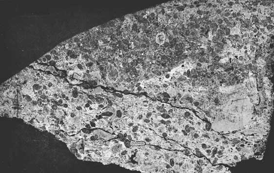
At the Elmdale section (Appendix) the lower Orbiculoidea-bearing black shale of the Bennett Member is reduced in thickness to about 0.1 foot. The shale lies below 5 to 6 feet of predominantly pure, massive, and resistant limestone (Pl. 3A) which contains a few fusulinids at the base. This limestone is similar in thickness, position, and fauna to the Bennett limestone exposed at Saffordville. Within the upper foot of this limestone sequence at the Elryidale section is linear algal limestone (Pl. 5A). About 4 feet of medium-gray calcareous shale rests on the thick Bennett limestone. A typical Bennett fauna of common brachiopods (Neospirifer, Linoproductus, Crurithyris, Ambocoelia, Wellerella), bryozoans (Fenestella, Rhombopora), foraniinifers, ostracodes, and fish teeth is abundantly represented in this shale.
Plate 5.--A, Peel print (x3.0) of upper Bennett limestone from Elmdale section. Wavy dark lines are sheetlike algal crusts (Anchicodium?). Note crust fragments in lower and upper left of picture. B, Peel print (x3.5) of Bennett limestone from Highway 38 section. Note wavy sheetlike algal crusts in lower half of picture and broken algal crusts with brachiopod fragments in upper half. Arrows point to top of bed. [Note: This image is scanned to be similar in size to that in the published book. A larger version is available to show more detail.]
Two feet of massive limestone enclosed by shale at the Turnpike section superficially resembles Glenrock Limestone. However, this designation is refuted by the presence in the limestone of Orbiculoidea, Fenestrellina, and linear algae typical of the Bennett Member and by the absence of fusulinids. This evidence indicates that the limestone may be a thin, tonguelike southward extension of the Bennett limestone facies. The Bennett limestone bed rests (paraconformably?) on shale of the upper Johnson Shale. Calcareous shale immediately above the limestone contains a profuse Bennett-like fauna. Equivalents of the lower Bennett Orbiculoidea-bearing black shale are absent from the Turnpike section.
Fossils in the 2 feet of limestone and shale observed at the Sallyards section indicate that these beds are also correlative with Bennett sediments farther north.
At the Piedmont section (Appendix) shaly light-gray limestone containing common fusulinids makes up the lower 1.5 feet of the Bennett exposure. The overlying 12 feet of massive, resistant, light-gray, medium- to thick-beddcd limestone forms the remainder of the Bennett Member at Piedmont. Orbiculoidea is present in the lowermost bed of this limestone. Fusulinids are rare to common throughout the section, together with a typical Bennett fauna with brachiopods, ostracodes, and crinoid discs. Some of the limestone is vuggy; other parts contain secondary chert nodules surrounding silicified fossils. South of the Piedmont section the lightgray limestone of the Bennett Member makes up most of the Red Eagle Limestone.
The basal shale is only 0.1 foot thick at the Grand Summit section (Appendix). This thickness is reminiscent of conditions at Elmdale. Orbiculoidea abounds in this shale, together with many fusulinids, ostracodes, conodonts, and brachiopod fragments. The rest of the Bennett is hard, light-gray, aphanitic limestone. The lower 4 feet of limestone weathers out as thin wavy beds in which linear algae are common. Five feet of massive thick- to medium-bedded limestone forms the medial part of the member. Thinner beds make up the upper 4 feet. Brachiopods, crinoid columnals, ostracodes,. and small gastropods are rare to common in an aphanitic matrix.
At the Highway 38 section (Appendix) the massive, light-gray, medium-bedded limestone which constitutes the entire Bennett Member is similar in thickness, purity, and lithology to its equivalent at the Grand Summit section. Of the sections studied, Highway 38 is the southernmost one in which correlations of the Red EagIe Limestone of Oklahoma with its members to the north can be recognized. Farther south the Glenrock Limestone probably disappears, whereas the Bennett limestone section thickens and becomes more argillaceous toward the Burbank area, where it makes up the bulk of the limestone defined as the Red Eagle Limestone formation.
Limestone of the Bennett Member at the Highway 38 section embodies characteristics typical of all limestone lithofacies of the Bennett Member. Fragments of brachiopods, bryozoans, and ostracodes are rare to common in an aphanitic calcareous matrix. Orbiculoidea and fusulinids are rare to common at the base of the unit and rare throughout the remainder. Linear algae (Anchicodium?) (Pl. 5B) are present in limestone near the base of the Bennett Member.
Summary-At the type area near Bennet, Nebraska, and southward to Manhattan, Kansas, the Bennett Shale Member is mainly calcareous, medium-gray, moderately to well-laminated shale. Brachiopod shells and spines are rare to common, whereas bryozoans, conodonts, foraminifers, ostracodes, and crinoid discs are rare. The lowest shale is fissile, dark gray or black, and characteristically contains numerous Orbiculoidea, but only a few conodonts andd fish teeth and even fewer fusulinids. The shale is easily identified in the field because it rests on the distinctive GIenrock Limestone. Sparse Orbiculoidea fragments may occur throughout the Bennett Member, regardless of lithology.
The Bennett Member is about 8 feet thick at Bennet, Nebraska, and gradually thins southward to 4 feet at Manhattan, Kansas. Between Manhattan and Paxico the Bennett "shale" becomes thicker (19 feet) and more calcareous until, at the Paxico section, only the basal black fissile shale maintains the typical northern character (approximately 30 percent CaCO3). In the same area the upper two-thirds of the Bennett Member appears in the field to consist of light-gray, very calcareous mudstone and shale. Laboratory analyses revealed that this is laminated muddy limestone containing approximately 70 percent calcium carbonate.
This argillaceous-calcareous facies of the Bennett Member continues southward to an area about 3 miles south of Eskridge, where the facies changes abruptly to include the medium-bedded, very pure (95 to 99 percent (CaCO3) limestone, 15 feet thick, at the Eskridge Quarry. The thickest part of this limestone facies of the Bennett Member trends in a band about 2 miles wide (Fig. 3) southwest from Bradford, through the Eskridge Quarry to the Coffman Ranch section, where it supports a conspicuous bench on local hillsides and creek banks. Sinkholes are present in this Iimestone. Brachiopods, crinoid columnals, horn corals, bryozoans, and fusulinids are rare to common throughout the limestone. Between the Coffman Ranch section and the Allen section the entire Bennett Member thins to about 8 feet. The pure limestone facies thins to about 2 feet, whereas the rest of the upper Bennett changes to muddy limestone facies like that at Paxico. In the short distance from the Allen section to Allen No. 2 section, the Bennett Member thins to less than 8 feet, the pure limestone becomes slightly argillaccous, and the muddy limestone becomes shaly.
The black and dark-gray lower shale of the Bennett maintains a thickness of about 1 foot in the area of the aforementioned facies changes of the medial and upper Bennett.
Southwestward from Allen No. 2 to Elmdale, the Bennett Member thickens slightly to more than 9 feet. The massive, pure limestone facies of the Bennett Member thickens to about 5 feet, whereas the basal black shale thins to less than 0.1 foot at the Elmdale section. Some of the massive limestone contains linear algae. Upper Bennett shale contains the same kind of mixed fauna as is visible in Nebraska.
Between Saffordville and Piedmont there are few sections of the Bennett Member suitable for sampling. Where it was studied, the member lacks black shale and is made up of fossiliferous gray shale overlying massive (1 to 2 feet), pure limestone beds similar to those at the Allen section.
In southern Kansas, between the Sallyards and Piedmont sections, the Bennett Member thickens and changes to a thick limestone facies very similar to the lithofacies at the Eskridge Quarry. This relatively thick (10 to 15 feet) limestone assemblage is continuous southward into Oklahoma, where it constitutes most of the Red Eagle Limestone. The basal Bennett black shale is scarcely an inch thick in southern Kansas but it is, nonetheless, readily recognizable at the base of the massive Bennett limestone.
Orbiculoidea fragments, so abundant in the Bennett black shale all the way from Nebraska into southern Kansas, are rare in the lower and middle portions of the Bennett limestone. Their presence (with a few fusulinids) in the lower Bennett limestone facilitates correlation, especially where the GIenrock Limestone and lower Bennett black shale are absent or not exposed.
Bennett Limestone is all nearly pure CaCO3 (95 to 99 percent) in southern Kansas. In northern Oklahoma it is more argillaceous (commonly 60 to 80 percent CaCO3). The limestone weathers to shades of light gray with tints of rusty yellow and brown.
Wherever the Bennett Member is composed of shale it underlies grassy slopes between the minor hillside benches supported by Howe and GIenrock Limestones. Bennett limestone facies of central and southern Kansas commonly form hillside benches which are more conspicuous than those supported by the thinner Glenrock and Howe Limestones to the north.
Howe Limestone Member
This upper member of the Red Eagle Limestone formation was named by Condra (1927, p. 86) ". . . from exposures south of Howe, Nebraska; stone in its unweathered condition, dark gray, massive, and dense, with considerable free calcite; weathers buff to yellowish, granular, vesicular or cavernous, and very irregular; thickness about 4 feet. This carries geodes at places. It has few fossils."
Only one small, incomplete exposure of this limestone is observable about half a mile south of Howe, Nemaha County, Nebraska. Condra's description seems to apply fairly well to this limestone, except that it understates the amount of solution pitting and decay.
The decayed limestone that Condra described is not satisfactory as a type section for reference in correlating Howe rocks of other localities. The limestone at the exposure designated by Condra is so badly pitted, decayed, and recrystallized as to preclude confident estimation of its original lithology. Moreover, there are no nearby exposures of Roca or fossil-bearing Bennett beds, which could aid in identification of the limestone as Howe on the basis of stratigraphic position.
In southeastern Nebraska the Howe Limestone is normally a light-gray aphanitic limestone that weathers to shades of rusty and yellowish light brown as a result of secondary iron oxide deposition within interstices of the rock. It is about 3 to 5 feet thick. The commonly pitted and irregularly cellular (vuggy) limestone has been partially dissolved by ground water in many places. Near the Pawnee section, springs of potable water emerge from the Howe Limestone. Iron oxides and travertine are being deposited in larger solution cavities (vugs) at the springs. The underlying fossiliferous shale in the Bennett serves as an effective aquifuge or aquiclude, preventing appreciable seepage of water downward from the Howe.
The Howe Limestone is well exposed at the Bennet and Pawnee sections. The latter would be a good standard section for the Howe Limestone in Nebraska. The lower contact is commonly gradational through a few inches of section into the shale of the topmost Bennett. This northern facies of the Howe Limestone contains few fossils, so that usually the Howe can be identified in the field only by lithology and stratigraphic position. Nebraska characteristics of the Howe Limestone may be followed southward to the Manhattan area of Kansas. Throughout this distance the Howe forms indistinct, light-brownish-gray or rusty-gray limestone benches cropping out on grassy hill slopes. Where it caps hilltops it is usually badly pitted, decayed, and iron stained. The thinner, fusulinid-bearing GIenrock bench is readily recognizable a few feet below the Howe.
A change of Howe facies occurs between the Manhattan and Paxico areas of Kansas. The northern aphanitic texture gives way to the pseudo-oolitic or pelletoid texture (osagite) that is visible in the vicinity of Paxico and Alma (Pl. 6B). This distinctive texture characterizes the Howe Limestone of central and south-central Kansas between Paxico and Grand Summit.
Plate 6.--A, Algal buns at top of Howe Limestone at Allen No. 2 section. B, Pelletoid Howe Limestone (osagite) from Alma section, magnified X30 from thin section. Pellets or pseudo-oolites are tiny fossil fragments (ostracodes, foraminifers, brachipods) covered by layers of algal (Osagia) calcium carbonate. C, Base of limestone bed in Roca Shale at Pawnee section. Raised, angular, wall-like structures fill cracks in top of underlying lower Roca Shale. [Note: Image on web page displayed larger than original to show more detail.]
The pseudo-oolites or pellets are calcareous nuclei, such as small foraminifers, ostracodes, or shell detritus, surrounded by coatings of algal calcium carbonate (Osagia sp.). Aggregates of these, with microcrystallliie interstitial cement, produce the pelletoid texture (osagite) characteristic of the Howe Limestone in central Kansas. The rock weathers to light gray, commonly stained by limonitic, rusty-yellow or brown iron oxides.
A very remarkable development of larger calcareous algal structures is present at the top of the Howe Limestone at the Allen No. 2 section. A thick pseudo-oolitic limestone bed makes up the bulk of the unit, but the upper 2 or 3 inches are bun-shaped or roughly hemispherical masses of concentrically layered algal calcium carbonate (Pl. 6A). O'Connor and Jewett (1952, p. 352) called these structures "Cryptozoon-like". One of these masses was underlain by a nautiloid cephalopod coated by half an inch of aphanitic, laminated, hard calcium carbonate (Pl. 7). The nautiloid was the top of the pelletoid limestone. Its suborthochoanitic siphuncle contains numerous osagitic pellets. Greenish shale of the overlying Roca Shale is impressed into and around the tops of the algal buns.
Plate 7.--Peel print (X3.0) of pelletoid Howe Limestone (pseudo-oolite or osagite) from Allen No. 2 section. Large fossil at left of picture is a coiled nautiloid cephalopod filled with clear sparry calcite and coated by Osagia type of algal calcium carbonate. Note that pellets are fossil fragmens (ostracodes, foraminifers, brachiopods) coated by Osagia. (See also Plate 6B.) Arrow points to top of bed. [Note: Image on web page displayed larger than original to show more detail.]
The distinctive pelletoid Howe facies (osagite) persists, with minor modification, southward to the vicinity of the Kansas-Oklahoma horder. At the Highway 38 section near Cloverdale, Kansas, the pellets are smaller and less distinct than in central Kansas. Also, the proportion of elongate or discoid pellets of calcium carbonate is greater, and algal coatings of the individual pellets are thinner.
In Oklahoma, because the pelletoid facies is absent, it is difficult to identify the Howe Limestone or its equivalents. Largely because of its stratigraphic position atop limestone of the Bennett and beneath red shale of the Roca, the irregularly and thinly bedded, pitted, rusty, sparsely fossiliferous limestone at the top of the Burbank section is correlated with the Howe Member of the Red Eagle Limestone.
Summary--The Howe Limestone Member of the Red Eagle Limestone is a massive limestone recognizable in exposures along nearly 250 miles of an outcrop belt between Bennet, Nebraska, and Cloverdale, Kansas. Throughout this distance the rock generally is 2 to 5 feet thick and it exhibits only one major facies change. In Nebraska and northern Kansas the Howe Member is an aphanitic light-gray limestone locally pitted and decayed by weathering. In central and southern Kansas the Howe Limestone is a brown to gray-brown peletoid limestone (osagite). The pellets are composed of fragments of organic shell detritus coated by algal (Osagia) calcium carbonate. Fossils are common to absent; a few ostracodes, brachiopods, and arenaceous foraminifers can be seen in some fresh exposures and in polished sections.Roca Shale
The Roca Shale was named by Condra (1927, p. 86) ". . . from Roca, Lancaster County, Nebraska; composed of bluish gray, olive green, and reddish argillaceous shale. There are thin fossiliferous limestone seams in the upper portion: thickness of division 18 to 20 feet in Nebraska and somewhat greater in Kansas. The limestone seams carry many pelecypods, as Pleurophorus sp., Pseudomonotis sp., and Aviculopecten occidentalis."
The pelecypod-bearing limestone ascribed by Condra to the upper portion of the Roca Shale is now known to be part of the Sallyards Limestone, the lowest unit of the Grenola Limestone (Condra and Busby, 1933, p. 7-10).
As implied by Condra and Busby (1933, p. 7) and recognized by later workers (e.g., Lane, 1958, p. 127), the upper boundary of the Roca Shale is at the base of the Sallyards Limestone. That is, the Sallyards is the first limestone above the red shale of the Roca Shale.
Thus, the Roca Shale formation is readily recognizable not only by its own red shale content, but by its position between the Howe Limestone below and the Pseudomonotis-bearing Sallyards Limestone above. It is characteristic of this portion of the Kansas rock column that correlation and identification of rock units is achievable only by recognition of unusual lithologies in their peculiar sequence. In this way the Roca Shale formation, in turn, may be used to affirm the stratigraphic position and boundaries of the Red Eagle Limestone below and the Grenola Limestone above.
The Roca Shale is not now exposed at Roca, Nebraska. A few slopes in the town are reddish, after the fashion of weathered red shale of the Roca visible elsewhere, but they owe their color to red Pleistocene silt and loess.
At the nearby Bennet section (Appendix), the lower 9.6 feet of the Roca Shale is well exposed. The lowermost approximately 3 feet consists of gray and greenish-gray, slightly calcareous shale with traces of ostracodes and gastropods. About 1 foot of hard, light-brownish-gray, aphanitic limestone separates the lower shale from overlying gray shale, which includes approximately 1 foot of vivid red mudstone. Gray shale below the redbeds contains a few ostracodes and rare traces of fish teeth. Shale above the redbeds is unfossiliferous. A thin, aphanitic, light-gray limestone caps the incompIete Roca exposure at the Bennet section. The complete Roca Shale thickness is estimated to be 15 feet.
Exposures of Roca Shale satisfactory for detailed sampling without risk of contamination are extremely rare in southeastern Nebraska and in Kansas. Shaly beds of the Roca commonly underlie broad, gentle, grassy slopes between limestone of the overlying Grenola Limestone formation and the underlying Red Eagle Limestone formation.
A partial exposure (lower 18 feet) of the Roca Shale occurs at the Pawnee section (Appendix). Above a 3.1-foot covered interval at the base is about 6 feet of light-greenish-gray calcareous mudstone and shale barren of fossils. This is overlain by 2 feet of massive, light-brownish-gray, hard, sublithographic limestone. The base of the limestone shows evidence of having covered and filled large cracks in the uppermost greenish-gray shale and mudstone. This feature can be seen on the weathered base of overturned slump blocks of the limestone (Pl. 6C). The limestone grades upward through 0.2 foot of laminated, flaky, argillaceous limestone and 0.2 foot of calcareous shale having traces of tiny gastropods, brachiopod fragments, and arenaceous foraminifers. The red mudstone next above is barren of fossils. Five feet of unfossillferous light-greenish-gray argillaceous limestone and shale make up the uppermost exposed beds. If unit thicknesses are disregarded, the sequence of green and red shale and limestone of the Pawnee section correlates satisfactorily with similar beds at the Bennet section despite the absence of fossils. Such correlation of subdivisions of the Roca Shale is not presently possible in Kansas because of numerous local inconspicuous changes in facies, lack of fossils, and distance between exposures.
The Roca Shale is entirely exposed and accessible at the Manhattan section (Appendix). The thickness of the unit here is 18.5 feet. Light-greenish-gray calcareous mudstone and shale are the principal rock types, but three units of maroon and red shale constitute nearly one-third of the sequence. Distinct calcareous nodules occur in some of the calcareous red shale. Some of the maroon beds grade to light-green color. A nodular microgranular limestone is present just below the middle of the unit. Rare traces of brachiopods (Cruithyris?) are present in greenish-gray shale near the middle of the unit.
At the Alma section (Appendix) the Roca Shale is 10 feet thick and composed chiefly of medium to light-gray and light-greenish-gray, slightly calcareous, unfossiliferous shale. There is a thin red shale (noncalcareous) near the top of the sequence and about 2 feet of limestone near the base.
The Roca is about 21 feet thick and contains several thin limestone beds at the Dunlap section (Appendix). One limestone, just below the middle of the unit, contains rare traces of ostracodes. As elsewhere, most of the Roca beds are light-greenish-gray, slightly calcareous, and unfossiliferous. Only 2 feet of the greenish shale is not calcareous. One bed of noncalcareous red shale occurs in the middle of the section.
The Roca Shale at the Elmdale section (Appendix) is predominantly light-greenish-gray or gray and only mildly calcareous. A maroon mudstone near the top of the unit is noncalcareous to slightly calcareous.
The same general characteristics of the Roca Shale observable at Elmdale persist through southern Kansas into Oklahoma. Traces of carbonaceous remains, ostracodes, and gastropods are present close to the top of the unit. In the area of the Kansas-Oklahoma border, the Roca Shale consists of an upper 6-foot division of buff-weathering gray shale and a lower one of red and maroon shale 11 feet thick (Taylor, 1953, p. 57).
At the Burbank section the lower 7 feet of the Roca Shale is red shale. Pinkish-gray shale 4 feet thick lies between the lower red shale and 6 feet of buff-weathering gray shale at the top of the unit. Traces of carbonaceous remains, ostracodes, and gastropods are present in the upper 2 feet of Roca beds at the Burbank section.
Summary--Good exposures are rarer for the Roca Shale than for other units of the Red Eagle cyclothem. Between Bennet, Nebraska, and Grand Summit, Kansas--a distance of 250 miles--the Roca Shale consists of light-gray, slightly calcareous shale commonly about 14 to 18 feet thick. Red shale and mudstone 1 or 2 feet thick is invariably present and conspicuous within the characteristic gray shale sequence. Except at the top, where traces of ostracodes and gastropods are sometimes found, the Roca Shale is almost entirely unfossiliferous.
In northern Oklahoma the lower one-third of the Roca Shale consists of red shale, succeeded upward by a sequence of gray shale which weathers light yellowish gray or buff.
Prev Page--Introduction || Next Page--Mineralogy and Paleontology
Kansas Geological Survey, Geology
Placed on web Jan. 4, 2007; originally published Dec. 1963.
Comments to webadmin@kgs.ku.edu
The URL for this page is http://www.kgs.ku.edu/Publications/Bulletins/164/03_strat.html