![]()
Prev Page--Geography || Next Page--Geomorphology
Geology in Relation to Ground Water
Indurated rocks of Pennsylvanian and Permian age crop out along the sides of Kansas River valley. The regional dip is westward about 15 feet per mile from Kiro to the vicinity of Belvue. From the vicinity of Belvue westward, the buried Nemaha Anticline causes a reversal, and the rocks dip gently eastward. Unconsolidated sediments of Quaternary age blanket most of the area, however.
For convenience in mapping and description, the limestones, shales, and sandstones of the Pennsylvanian and Permian Systems were grouped into units larger than formations as defined by Moore and others (1951). With the exception of the Council Grove Group (Permian), which was arbitrarily divided into three unequal parts, subgroups and groups were mapped as units. A generalized geologic section of the Pennsylvanian, Permian, and Quaternary units mapped is given in Table 1.
Table 1--Generalized section of outcropping rocks of Kansas River valley between Wamego and Topeka vicinity.
| System | Series | Group | Subgroup or stage |
Formation | Member | Thickness (feet) |
Character | Water supply |
|---|---|---|---|---|---|---|---|---|
| Quaternary | Pleistocene | Sanborn | Recent | Dune Sand | 0-10 | Sand. silty and clayey, uniform throughout, light gray to tan. | Lies above the water table. | |
| Wisconsinan and Recent |
Alluvium | 18-85 | Clay, silt, sand, and gravel, well-sorted in major valleys, generally fine-textured near top, grading downward into coarse sand and gravel. | Yields large amounts of water to irrigation, municipal. domestic, and stock wells. Water generally of good quality. | ||||
| Wisconsinan | Terrace deposits (Newman) |
0-90 | Silt and clay, gray in upper part, grades downward into coarse sand and gravel. | Yields large quantities of water to irrigation, municipal, domestic, and stock wells. Water generally of good quality. | ||||
| Peoria | 0-10 | Silt, eolian, well-sorted, light gray to gray tan. Thin mantle on uplands south of Kansas River. | Generally above water table, but may yield small quantities of water to shallow wells locally. | |||||
| Illinoian | Loveland | 0-10 | Silt. eolian, well-sorted reddish to pinkish brown. Thin mantle on upland north and south of Kansas River. | Generally above water table, yields little or no water. | ||||
| Terrace deposits (Buck Creek) |
0-95 | Sand, sandy silt, fine gravel in lower part grading upward into reddish-brown to reddish-tan silt, fluvial. | Locally, basal part yields moderate amounts of water to wells (as much as 625 gpm). | |||||
| Meade | Kansan | Terrace deposits (Menoken) |
0-15 | Silt and sandy silt, reddish tan to reddish brown. | Generally above water table, and does not yield water. | |||
| 0-20 | Pebbles, cobbles, and boulders at the base; contains many lenses of arkosic sand. | May yield abundant amounts of water where in the zone of saturation. | ||||||
| Kansas Till | 0-84 | Till, principally clay and silt, reddish brown to brown at surface. blue gray at depth; contains some pebbles, cobbles, boulders, and interstratified sands. | Generally a poor source of water. Sand lenses may contain small amounts of water. | |||||
| Nebraskan (?) | Undifferentiated pre-Kansan gravels |
0-10 | Chert-limestone gravel in clay matrix. | Too limited in extent to be of importance as an aquifer. | ||||
| Permian | Wolfcampian | Council Grove |
Beattie Limestone |
Florena Shale |
2-8 | Shale, calcareous, silty, gray to tan. | Yields little or no water. | |
| Cottonwood Limestone |
4-6 | Limestone, massive, tan; contains flint nodules. | Locally, may yield water. | |||||
| Eskridge Shale |
25-35 | Shale, clayey, silty, calcareous, variegated. | Yields little or no water. | |||||
| Grenola Limestone |
Neva Limestone |
8-10 | Limestone and interbedded shale. clayey, tan, weathers honeycombed. | Locally, the massive middle part may yield small amounts of water. | ||||
| Salem Point Shale |
8-12 | Shale, clayey, tan on weathered surface, dark gray on fresh exposures. | Yields little or no water. | |||||
| Burr Limestone |
6-8 | Limestone, tan to brown; two layers separated by shale. | Locally, may yield small amounts of water. | |||||
| Legion Shale |
2-4 | Shale, silty, clayey, tan to gray. | Yields little or no water. | |||||
| Sallyards Limestone |
1 | Limestone, gray. | Yields little or no water. | |||||
| Roca Shale | 25-30 | Shale, silty, clayey, calcareous, variegated. | Yields little or no water. | |||||
| Red Eagle Limestone |
Howe Limestone |
2-4 | Limestone, dense; porous when weathered. | May yield small amounts of water. | ||||
| Bennett Shale |
10-15 | Shale, clayey, silty, calcareous, fossiliferous, gray to tan. | Yields little or no water. | |||||
| Glenrock Limestone |
2-4 | Limestone, argillaceous, thin bedded, gray. | Yields little or no water. | |||||
| Johnson Shale |
15-20 | Shale, clayey, silty, calcareous in part, gray to green. | Yields little or no water. | |||||
| Foraker Limestone |
Long Creek Limestone |
10 | Limestone, porous, gray;contains celestite and quartz geodes. | Yields moderate quantities of water in other areas. | ||||
| Hughes Creek Shale |
15-25 | Shale, silty, calcareous, gray. | Yields little or no water. | |||||
| Americus Limestone |
5 | Limestone, dense; two layers separated by shale. | May yield small amounts of water. | |||||
| Admire | Hamlin Shale | 40-50 | Shale, clayey, gray in upper part, variegated in lower; limestone between members. | Yields little or no water. | ||||
| Five Point Limestone |
4-6 | Limestone, thin bedded, slightly porous. | May yield small amounts of water. | |||||
| West Branch Shale | 25-35 | Shale, clayey, variegated; contains limestone lenses. | Yields little or no water. | |||||
| Falls City Limestone |
2 | Limestone, massive, gray to tan. | May yield some water. | |||||
| Hawxby Shale |
6-15 | Shale, clayey to sandy, gray to yellow. | Yields little or no water. | |||||
| Aspinwall Limestone |
1-3 | Limestone, massive to thin bedded, reddish brown. | May yield small amounts of water. | |||||
| Towle Shale | 5-15 | Shale, clayey, silty, calcareous: Indian Cave sandstone member present locally. | Sandy beds may yield moderate amounts of water. | |||||
| Pennsylvanian | Virgilian | Wabaunsee | Richardson | Brownville Limestone |
4 | Limestone, massive, fossiliferous, brown. | Yields little or no water. | |
| Pony Creek Shale |
15-25 | Shale, clayey, silty, variegated; is siltstone in places. | Yields little or no water. | |||||
| Caneyville Limestone |
10-12 | Limestone, thin bedded to massive. gray; two beds separated by shale. | May yield small amounts of water. | |||||
| French Creek Shale |
20-30 | Shale, clayey and sandy, tan to light brown. | Yields little or no water. | |||||
| Jim Creek Limestone |
1-2 | Limestone, dense, massive, blue gray. | Yields little or no water. | |||||
| Friedrich Shale |
25-30 | Shale, clayey, sandy, contains lenses of limestone. | Sandy layers may yield small quantities of water. | |||||
| Grandhaven Limestone |
4-6 | Limestone, thin bedded to massive, blue gray; two beds separated by shale. | A possible source of small amounts of water. | |||||
| Dry Shale |
10-15 | Shale, clayey, sandy, variegated. | Yields little or no water. | |||||
| Dover Limestone |
3 | Limestone, thin bedded to massive, gray to tan. | May yield small quantities of water. | |||||
| Langdon Shale | 25-30 | Shale, clayey to sandy, blue gray to tan. | Sandy layers in upper part may yield small amounts of water. | |||||
| Maple Hill Limestone |
2-4 | Limestone, massive to thin bedded, gray to tan. | May yield small amounts of water. | |||||
| Pierson Point Shale |
15-20 | Shale, clayey, micaceous, blue gray to black, weathers tan. | May yield small amounts of water from sandy layers. | |||||
| Nemaha | Tarkio Limestone |
3-5 | Limestone, massive, fusulinid bearing; brown to tan. | May yield small amounts of water. | ||||
| Willard Shale |
30-40 | Shale, clayey, dark gray to brown; contains sandy layers. | Sandy layers may yield small amounts of water. | |||||
| Elmont Limestone |
1-2 | Limestone, massive, jointed, dark blue to gray. | Some water may be derived from joints and fractures. | |||||
| Harveyville Shale |
15-20 | Shale, clayey, sandy, blue to greenish brown. | The thin platy sandstones may yield some water. | |||||
| Reading Limestone |
2-3 | Limestone, weathers into three layers, dark gray to brown. | May yield small amounts of water. | |||||
| Auburn Shale | 10-15 | Shale, clayey, gray to tan; contains sandy and limy layers. | Sandy and limy layers may yield some water. | |||||
| Wakarusa Limestone |
4-6 | Limestone, fossiliferous, dark gray to brown; contains shale layers. | May yield small amounts of water. | |||||
| Soldier Creek Shale |
15-20 | Shale, clayey to sandy, blue gray to tan. | Sandy layers are possible sources of some water. | |||||
| Burlingame Limestone |
4-6 | Limestone, thick bedded, brown; contains shale partings. | May yield moderate amounts of water. | |||||
| Sacfox | Silver Lake Shale |
±30 | Shale, clayey, gray to yellow, contains impure limestone lenses. | Limestone lenses may yield small amounts of water. | ||||
| Rulo Limestone | ±2 | Limestone, bluish gray. | Yields little or no water. |
Pennsylvanian System
Virgillian Series
Wabaunsee Group
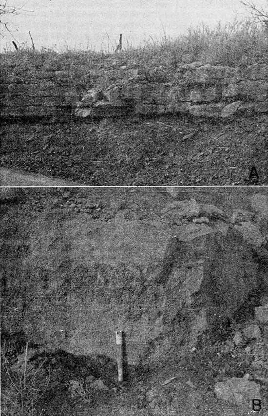
Sacfox Subgroup--Strata of the Wabaunsee Group exposed below the base of the Burlingame Limestone were mapped as the Sacfox Subgroup. Only the Silver Lake Shale and Rulo Limestone are exposed. They crop out on the south side of the river at the base of the bluff east of Mission Creek (Pl. 1).
The Silver Lake Shale is blue gray and weathers gray to yellow (Pl. 4A). It is clayey and contains thin lenticular beds of impure platy limestone. The Rulo Limestone is blue gray and weathers mottled light and dark brown. The exposed thickness of the Sacfox Subgroup is about 32 feet. No wells that yielded water from the Sacfox Subgroup were inventoried.
Plate 4--A, Silver Lake Shale and overlying Burlingame Limestone in road cut in SE NE sec. 36, T. 11 S., R. 14 E. B, Tarkio Limestone in quarry in sec. 29, T. 11 S., R. 14 E.
Nemaha Subgroup--The Nemaha Subgroup includes strata from the base of the Burlingame Limestone to the top of the Tarkio Limestone. The contact between the Sacfox Subgroup and the Nemaha Subgroup is conformable. The outcrops of the subgroup are most extensive on the south side of the river east of Maple Hill (Pl. 1); there are less extensive outcrops on the north valley wall, where overlying Quaternary sediments have been removed by erosion.
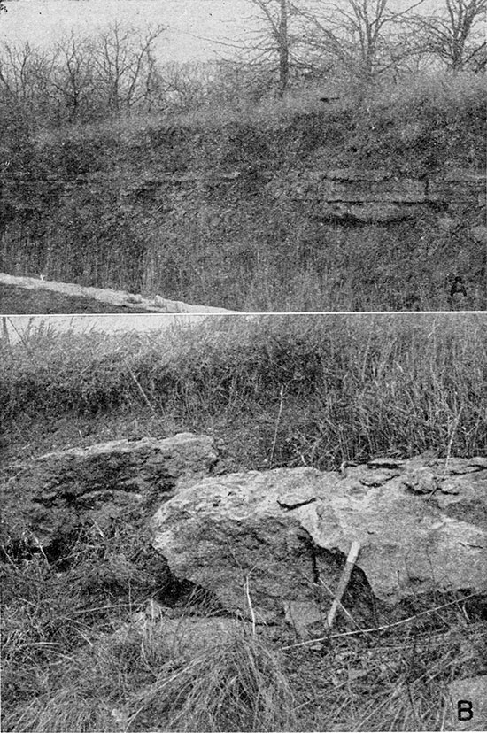
The limestone formations in the Nemaha Subgroup range in thickness from 1 to 6 feet and the shales from 10 to 40 feet. The limestones are generally fossiliferous and brown and weather mottled brown. In limestone formations that contain two or more layers, the layers are separated by thin shale partings. The Tarkio Limestone (Pl. 4B) may be identified on the basis of large fusulinids and algal remains, and the Reading Limestone may be identified easily in a weathered exposure because it weathers into three or four layers of uniform thickness (Pl. 5A). The shales are generally dark gray or blue and weather gray or light tan. They are generally clayey and contain calcareous layers just below the limestones. Lenticular layers of clayey limestone are common in the Auburn Shale.
Good exposures of the Nemaha Subgroup may be seen in road cuts along Kansas Highway 10 and U. S. Highway 40 in Shawnee County. The total thickness of the subgroup may be as much as 117 feet, but is about 90 feet in the area mapped. Laterally the shales and limestones thicken and thin somewhat, making it difficult to trace formations on the basis of thickness alone. Wells of small yield may be developed locally in the weathered zones of the limestones and shales of the Nemaha Subgroup. Analyses of water from this subgroup in adjacent areas indicate that the water is hard.
Richardson Subgroup--The Richardson Subgroup includes the limestone and shale formations from the top of the Tarkio Limestone to the top of the Brownville Limestone. The subgroup crops out generally on the sides of the valley from the vicinity of Willard west to Turkey and Bourbonais Creeks and from Wamego west to Range 9 East. In the central and western parts of the valley, much of the subgroup is covered by younger sediments.
The Richardson Subgroup is composed predominantly of clayey and sandy blue-gray shale, but parts of the Pony Creek and Dry Shales are variegated red and green. The sandy beds may be micaceous, yellow or brown, loosely cemented sandstone. The Friedrich Shale locally contains sandstone-filled channels cut down as much as 25 feet into lower beds. Most of the shales in this unit contain thin coal beds a fraction of an inch to 2 inches thick. Some parts of the shales are calcareous or contain thin limestone.
Plate 5--A, Reading Limestone underlying Harveyville Shale and overlying Auburn Shale in road cut in SW SW sec. 30, T. 11 S., R. 14 E. B, Brownville Limestone capping hill in SW SW sec. 18, T. 10 S., R. 13 E.
The limestone formations are blue gray to gray and weather tan or brown. They generally contain one or two layers and may weather into platy limestones. Where the limestone formations are composed of two or more layers, the shale partings nowhere are more than a few inches thick. Characteristic fossils in the limestones are fusulinids, brachiopods, and pelecypods and other mollusks. Meekopora and Chonetes are distinctive in the Brownville Limestone, and local algal or algal-like deposits are prominent in the upper part of the Grandhaven and Dover Limestones. The most prominent outcropping limestones are the Brownville, Dover, and Maple Hill.
The thickness of the Richardson Subgroup is 150 feet. The individual shales range in thickness from 10 to 30 feet in this part of Kansas, and the limestones from 1 to 12 feet. The Grandhaven Limestone southeast of Maple Hill, consisting of two layers of limestone and an intervening shale layer, is about 6 feet thick. The Brownville Limestone (Pl. 5B) is the thickest single bed of limestone in this subgroup and is about 4 feet thick.
Some stock wells south of the river yield small supplies of water from one or more of the limestones of the Richardson Subgroup. Many ponds have been constructed in the outcrop region of the Richardson Subgroup to supplement the ground-water supply.
Permian System
Wolfcampian Series
All the Permian rocks exposed in Kansas River valley are included in the Wolfcampian Series. The base of the Permian System is the Indian Cave Sandstone member of the Towle Shale. The Indian Cave Sandstone was not observed in this area, but may be present locally. Permian rocks crop out from Cross and Mill Creeks westward, as shown on Plate 1.
Admire Group
The Admire Group is composed of four shale and three limestone formations and has been mapped as a single unit. The most extensive outcrops of the Admire Group are in the divide area between Mill Creek and Kansas River and northeast of St. Marys. In Roberts and Wells Creek valleys south of Kansas River, the group is covered extensively by a terrace deposited during the Illinoian Stage of the Pleistocene Epoch. Elsewhere, the group is concealed by thin deposits of weathered Kansas Till.
The shales of the Admire Group are chiefly clayey, but some are silty, calcareous, or sandy. The shales are very thin bedded to almost fissile. They are dark blue gray and weather light gray or tan. The Hawxby Shale contains many thin-bedded clayey limestone lenses.
The limestones are generally gray or light brown and weather tan or buff and are generally massive but weather thin bedded or platy. The Five Point Limestone, the upper limestone of this group, probably is the most porous.
The maximum thickness of the Admire Group is about 125 feet. About 115 feet of this thickness is shale and the other 10 feet is limestone. Individual limestone formations are 1 to 6 feet thick in this area. The Five Point Limestone consists of two limestone layers separated by a thin shale and its total thickness is about 6 feet; the Falls City Limestone is about 2 feet thick; and the Aspinwall Limestone is 1 to 3 feet thick.
A few stock wells probably obtain small supplies of ground water from the Five Point Limestone.
Council Grove Group
The Council Grove Group includes rocks from the base of the Foraker Limestone to the base of the Wreford Limestone. In Kansas River valley the lower seven formations of the group are exposed. These formations were divided into three units for convenience of mapping and description. The lower unit includes strata from the base of the Americus Limestone member of the Foraker Limestone to the base of the Burr Limestone member of the Grenola Limestone; the middle unit includes strata from the base of the Burr Limestone to the base of the Cottonwood Limestone member of the Beattie Limestone; and the upper unit includes the Cottonwood Limestone and Florena Shale members of the Beattie Limestone. The formations crop out from about 4 miles east of St. Marys to the vicinity of Wamego. Many of the limestones produce prominent topographic benches.
Lower unit--The Americus Limestone is the basal member in the lower unit of the Council Grove Group and conformably overlies the Hamlin Shale of the Admire Group. The lower unit is exposed most extensively on the north side of the valley from St. Marys west, where it forms part of the north bluff of the valley. In the valleys of south-flowing tributaries to Kansas River, it has been covered by fills of Pleistocene age. Extensive areas northwest of Maple Hill are underlain by members of this unit. Terrace deposits cover all but the uppermost strata of the lower unit in the vicinity of Roberts and Wells creeks.
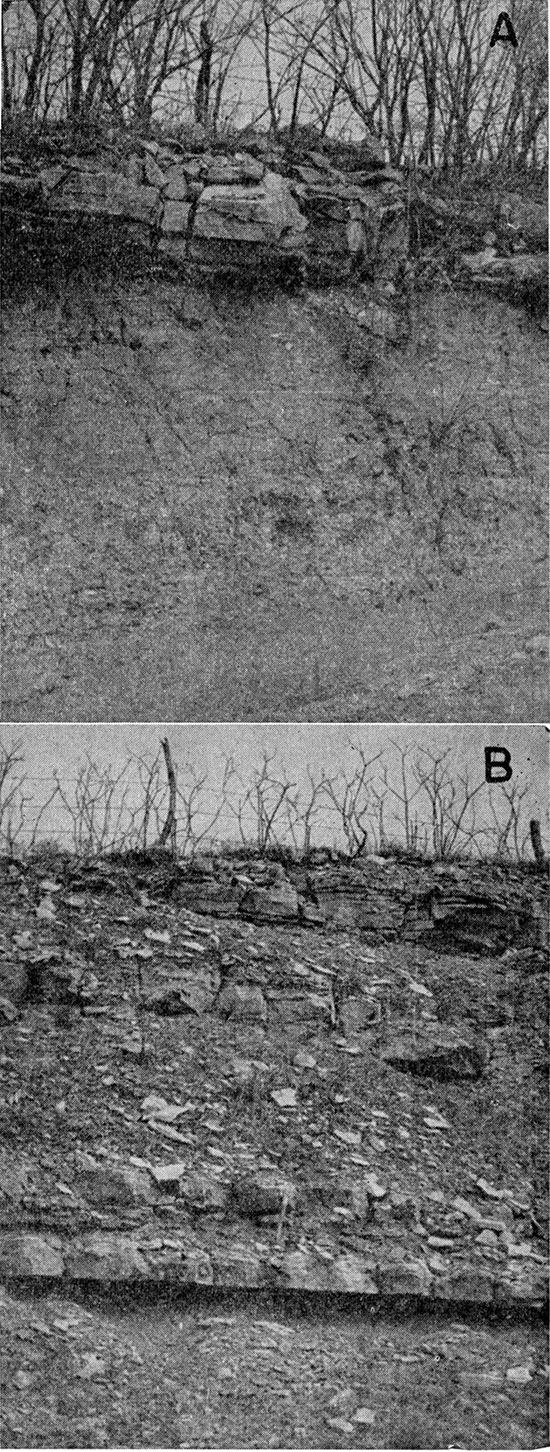
The lower unit includes the Foraker Limestone, Johnson Shale, Red Eagle Limestone, Roca Shale, and the lower two members of the Grenola Limestone. The limestones in the Council Grove lower unit are generally massive and dense. The exception is the Long Creek Limestone, which is argillaceous, porous, and thin bedded. It contains many nodules and geodes of celestite and quartz, indicative of subsurface water action. The shales in the lower part of the unit are dark-gray to green clayey shales and contain lenses of very fossiliferous argillaceous limestone. One argillaceous limestone lens in the Hughes Creek Shale member contains very abundant fusulinids, and one in the Bennett Shale member contains an abundance of the brachiopods Marginifera, Composita, and Orbiculoidea. The Roca Shale is variegated red, green, and tan and is nonfossiliferous. Outcrops of the Sallyards Limestone and Legion Shale members of the Grenola Limestone are shown on Plate 6B.
Plate 6--A, Eskridge Shale capped by Cottonwood Limestone member of Beattie Limestone in SW SW sec. 16, T. 9 S., R. 12 E. B, Burr Limestone, Legion Shale, and Sallyards Limestone members of Grenola Limestone in road cut along Kansas Highway 63, north of St. Marys.
The shales of this unit range in thickness from 2 to 30 feet. The Roca Shale generally is the thickest and the Legion Shale member the thinnest. Except the Long Creek Limestone member, which is commonly about 10 feet thick, the limestone strata range in thickness from 1 to 5 feet.
The weathered zones of the calcareous shales are possible sources of small quantities of ground water. Seeps from the calcareous parts of the Hughes Creek Shale and Bennett Shale are common, and some springs were observed issuing from the base of the Howe Limestone member. The best source of ground water from the lower unit is the Long Creek Limestone member, and some of the upland wells south of Belvue were reported to produce a maximum of about 10 gallons a minute from it.
Middle unit--The Burr Limestone, Salem Point Shale, and Neva Limestone members of the Grenola Limestone and the Eskridge Shale are included in the middle unit of the Council Grove Group (Pl. 1). The Burr Limestone and Cottonwood Limestone members form prominent rock terraces. The unit underlies the divides both north and south of Kansas River and is covered by thin deposits of weathered till or residual mantle.
The predominant material of this unit is shale. The Eskridge Shale is clayey, variegated green, red, and tan, and weathers blocky (Pl. 6A). In some localities it contains thin argillaceous limestones. A limestone layer in the upper part of the Eskridge Shale contains abundant pelecypods Myalina and Aviculopecten. The Salem Point Shale member between the Neva Limestone and the Burr Limestone is generally clayey and dark gray and weathers tan.
The limestone members present in the middle unit are the Burr and Neva Limestones. The Burr Limestone member (Pl. 6B) consists of two beds separated by a thin shale, and both beds are dense, massive, and tan. The bottom of the lowermost bed is oolitic and has a sandy appearance. The Neva Limestone member consists of three beds of limestone separated by thin shales, the middle limestone bed being much thicker than the lower and upper. Weathered outcrops of the middle limestone are thin bedded and locally honeycombed. The middle bed is light gray to tan, and the color is not altered by weathering.
The formations of the middle unit of the Council Grove Group have a combined thickness of about 65 feet. Thickness of the Eskridge Shale ranges from 25 to 35 feet, of the Neva Limestone member from 8 to 10 feet, of the Salem Point Shale member from 8 to 12 feet, and of the Burr Limestone member from 6 to 8 feet.
The Neva and Burr Limestone members are the best aquifers in the middle unit. Several domestic and stock wells in areas adjacent to Kansas River valley obtain small supplies of ground water from the Neva Limestone.
Upper unit--The strata included in the upper unit of the Council Grove Croup are the Cottonwood Limestone and Florena Shale members of the Beattie Limestone. They crop out on the crest of the divide north of St. Marys and in the upland southwest of Belvue.
The Cottonwood Limestone member is a massive tan limestone (Pl. 6A) and is recognizable because of an abundance of slender fusulinids in the upper part and Hint nodules in horizontal layers at three or four levels in the massive layer. The lower 1 to 2 feet is fractured in an irregular pattern; otherwise, the member is a single massive layer about 5 feet thick.
The Florena Shale member is calcareous and silty, and its lower part is fossiliferous in most exposures. One of the most abundant fossils is Chonetes. The member is deeply weathered in exposures, is gray to tan, and is 2 to 8 feet thick.
The Cottonwood Limestone member is not an important aquifer in this area. Some seepage between the Florena Shale member and the overlying mantle was noted in the divide areas.
Quaternary System
Pleistocene Series
Quaternary deposits in Kansas River valley range in age from pre-Kansan to Recent and disconformably overlie the Paleozoic rocks of Permian and Pennsylvanian age. The oldest sediments are gravels that contain no material of glacial origin and are classed as pre-Kansan. The most recent deposits are sand dunes formed from the alluvial sands of the present river channel. The Quaternary deposits are the principal source of ground water in Kansas River valley and the adjacent upland. They are also the parent material from which most of the soils have developed.
Figure 4--Idealized geologic sections showing development of Kansas River valley.
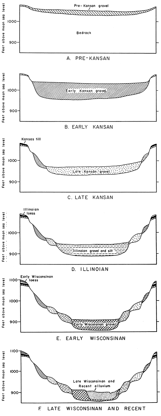
Pre-Kansan Gravels
Gravels classed as pre-Kansan (Nebraskan or Tertiary?) occur in small isolated deposits high on the divides above Kansas River northeast of Rossville and northwest of Wamego. The gravels are composed principally of chert and limestone and contain very small quantities of erratic material. Davis (1951) concluded that their composition is considerably different from glacial outwash, and he classed them as pre-Kansan or remote Kansan proglacial gravels. The constituent particles of chert and limestone are subangular to subrounded fragments, which could have been derived from Paleozoic limestones cropping out west of this area.
The thickness of the gravels ranges from a featheredge to 10 feet and averages about 5 feet. The gravels cannot be traced laterally any great distance because they have been eroded since their deposition. They are embedded in a matrix of clay, which decreases the porosity and permeability of these deposits; hence the gravels are not an important source of ground water.
Kansas Till
Deposits consisting of clay, sand, gravel, and boulders are present over part of the area on the crests of the divides and on the sides of the valley. In two upland areas, east of Cross Creek and northwest of Wamego, the till is as much as 84 feet thick, but in places the till has been eroded and only a thin veneer remains.
Locally the Kansas Till mapped on Plate 1 includes stratified sand and gravel at the base or interbedded with the till. The stratified deposits probably are meltwater deposits associated with the ice front of the Kansan glacier.
The till is composed of clay containing some erratics and limestone fragments. A very heavy concentration of glacial boulders rests on the Permian bedrock southwest of Belvue. Much of the finer material has been removed from the till, resulting in a concentration of boulders forming stone stripes. Most exposures are either in road ditches or stream cuts; hence only a few feet of material can be observed. A typical exposure is a gully in the SE SW sec. 35, T. 11 S., R. 13 E. The till, composed principally of clay containing fragments of chert, quartzite, and greenstone ranging in size from granules to boulders, is blocky and mottled gray and rust brown. The till exposed in a road ditch in the NW NW sec. 1, T. 11 S., R. 14 E., is red to brown clay containing a mixture of granules of chert, quartzite, and dark igneous rock. Till that is well oxidized but only slightly leached is exposed in the center of sec. 3, T. 11 S., R. 14 E. It is very tight clay containing granules of limestone, chert, and igneous and metamorphic rocks, especially quartzite.
Quartzite and quartzite conglomerate are the two most common rock materials in areas where boulders are the only part of the till remaining; they are more resistant to chemical weathering than other kinds of rocks. In till that has not been leached and oxidized, cobbles of granite and some dark igneous rock are fairly abundant. Davis and Carlson (1952) described the zones of the Kansas Till from their work and that of Frye and Walters (1950) as follows:
- Red clay zone. Deeply leached and oxidized zone, red, containing exclusively siliceous pebbles in the coarser fraction; commonly modified by colluvial action.
- Mottled gray clay zone. Leached and Oxidized, mottled gray and light brown, containing almost entirely siliceous pebbles, limonitic shale fragments, and various metamorphic rocks; locally jointed.
- Oxidized and unleached till. Yellow brown to green brown containing abundant limestone, chert, shale, and granitic pebbles; ferromagnesian minerals in rock are altered near the rock surfaces, and limestone is slightly etched; till is commonly jointed.
- Unoxidized and unleached till. Dark blue gray, has essentially the same pebble content as C; very hard and impervious as compared to other zones; may contain interstratified sand and gravel in thicker portions.
Test hole 10-14-32cc penetrated 84 feet of interbedded sand, clay, and gravel. The lower 26 feet was medium to coarse sand and gravel composed of quartz and limestone. Such gravels are characteristic of the pro-Kansan gravels of Davis (1951) and may correlate with the Atchison Formation in the northeastern corner of the state. The upper 58 feet consisted of clay and fine sand interbedded with some pebbles of limestone, quartzite, and dark igneous rock typical of Kansas Till. Test hole 10-14-32bb penetrated about 72 feet of interbedded clay, sand, and gravel. These two test holes probably penetrated about the maximum thickness of till in the area. Colluvial and fluvial processes have removed much of the till from slopes of the valley walls, and in many places it was too thin to map on Plate 1.
The sandy layers in the till yield small supplies of ground water to wells. The clays are too impermeable to yield much water.
Menoken Terrace Deposits
Material mapped as the Menoken Terrace deposits was deposited by meltwater from the retreating ice front and is Kansan in age. Originally these deposits probably were continuous in the valley (Fig. 4), but erosion has so dissected the surface that only remnants remain. They occupy a terrace position, and the most extensive deposits are on the north side of the valley east of Rossville. Other isolated deposits are on both sides of the valley as far west as Deep Creek. Menoken Terrace deposits are underlain either by bedrock of Paleozoic age or by gravels of Cenozoic age, and the floor of the Menoken Terrace deposits ranges from 20 to 40 feet above the present flood plain.
Gravels of the Menoken Terrace deposits can be distinguished from gravels at the base of the Kansas Till by their composition. About 10 percent of the gravel in the terrace deposits was derived from igneous or metamorphic rocks, whereas not more than 2 percent of the gravels at the base of the Kansas Till was derived from igneous or metamorphic rocks (Davis, 1951). The gravels of Illinoian and Wisconsinan age have a still greater percentage of granitic material, which distinguishes them from Kansan and pre-Kansan gravel deposits. Gravel about 7 feet thick, composed of limestone and chert, is exposed in a pit in the SE SE sec. 24, T. 11 S., R. 13 E. It is overlain by well-sorted arkosic gravel. A gravel composed of limestone and chert, containing less than 5 percent quartzite and dark igneous rock fragments, irregularly cemented with calcium carbonate to produce a conglomerate is exposed in a pit in the SW SE sec. 4, T. 10 S., R. 12 E. The deposit is overlain by fine arkosic sand and silt and overlies the Red Eagle Limestone of Permian age.
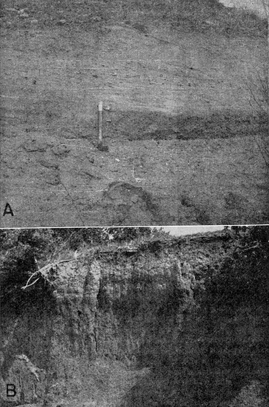
About 20 feet of sand and gravel overlying the Nemaha Subgroup is exposed in a sand and gravel pit in the NW SE sec. 12, T. 11 S., R. 14 E. The lower 6 feet of gravel consists of well-rounded limestone and quartzite fragments as much as 8 inches in diameter and some chert and micaceous shale fragments. This deposit grades upward into well-sorted medium-coarse arkosic sand. The uppermost part of the deposit consists of fine sand, stained brown or black, and silt and clay. Menoken Terrace deposits also are exposed in a large pit in the SW SW sec. 36, T. 10 S., R. 13 E. (Pl. 7A). This exposure shows much crossbedding and sorting of material, which suggest its water-laid origin. The reddish sandy silt at the top of the cut is 10 to 15 feet thick. The stream-deposited gravels in the lower part of the Menoken Terrace deposits may possibly correlate with the Grand Island Formation in western Kansas, and the reddish silt and clay may be equivalent to the Sappa Formation.
No wells were inventoried that produce water from the Menoken Terrace deposits. The terrace has been dissected by erosion, and permeable basal gravels are nearly drained.
Plate 7--A, Sand and gravel deposits of Menoken Terrace in pit in SW SW sec. 36, T. 10 S., R. 13 E. B, Soil profile on Newman Terrace in NW NW sec. 33, T. 10 S., R. 12 E.
Buck Creek Terrace Deposits
The Buck Creek Terrace deposits were laid down during the Illinoian Stage of the Pleistocene Epoch, and these deposits in Kansas River valley and its tributaries are topographically lower than the Menoken Terrace deposits (Pl. 1).
South of the river opposite Belvue a large remnant of the Buck Creek Terrace deposits shows features characteristic of alluvial terraces, and the terrace surface can be traced eastward to Mill Creek. Isolated deposits are present on the north side of the river, the largest remnant being on the west side of Cross Creek valley north of Rossville. Alluvial fills in many of the tributaries were mapped as Buck Creek Terrace deposits. The fills possibly contain material derived from the divides by colluvial action, but most of it is alluvium.
Buck Creek Terrace deposits contain sand and gravel in the lower part and grade upward into silt and clay. Test hole 11-12-12ad penetrated about 15 feet of coarse sand and gravel below the silt and clay. The sand and gravel is arkosic in Kansas River valley but contains a few fragments of locally derived limestone and chert. The gravel particles are principally quartz and granite fragments that are well rounded, indicating that they were transported for considerable distance before being deposited.
The silt and clay are characterized by a red-brown color and uniform texture; they weather blocky or columnar. The presence of pebbles in the silt in some localities suggests that the material is alluvial in origin.
A good soil profile has developed on the upper part of the Buck Creek Terrace deposits and is exposed in a road cut just south of Kansas River in the NW NW sec. 7, T. 11 S., R. 13 E. The upper 15 inches is dark brownish gray, leached, and friable. The lower 30 inches is lighter in color, oxidized, and only slightly leached.
Eight test holes were drilled in the Buck Creek Terrace deposits to determine the thickness of sand, gravel, silt, and clay and the altitude of the bedrock surface. The thickness of these deposits ranges from about 35 feet in test hole 10-11-7ad to 96 feet in test hole 9-11-19cd. Thickness of the sand and gravel in the lower part of the terrace deposit ranges from 3 feet in test hole 10-11-17aa to 57 feet in test hole 9-11-19cd, which was the only test hole to penetrate more than 20 feet of sand and gravel. Thickness of the sand and gravel is commonly 8 to 15 feet and that of the silt and clay ranges from 10 to 47 feet.
Six wells that produce water from sand and gravel of the Buck Creek Terrace deposits were inventoried. Well 10-10-30db is 59 feet deep and penetrates 14 feet of saturated material. The estimated yield was 475 gpm, but information was not available to determine the specific capacity. Well 10-10-28bc is 48 feet deep, penetrates 26 feet of saturated material, and by report yields 625 gpm.
Loveland and Peoria Formations Undifferentiated
The sediments mapped as the Loveland and Peoria Formations on Plate 1 are materials deposited on the upland by wind action. The Loveland and Peoria loesses are both present. The Loveland loess is the more widespread and was observed chiefly in the eastern third of the area, where it caps the upland northeast of Cross Creek and Kansas River. Some of the loess south of Willard on the divide area is probably Loveland, but it has been blanketed by the Peoria loess over most of the area south of the river. In much of the area the loesses have been removed by erosion, were never deposited, or were too thin to map.
Loveland loess is material blown from the major valleys and deposited on the upland during the Illinoian Stage of the Pleistocene Epoch. The material is mostly reddish to pinkish-brown friable silt and some clay. The loess becomes clayey and blocky where weathering has caused deflocculation of the clay. In some places there is a concentration of calcium carbonate in the lower part of the B zone and in the upper part of the C zone of the soil profile. The soil profile is similar to that developed on the Buck Creek Terrace deposits, and the two are thought to be about the same age.
Peoria loess is generally light gray or gray tan in contrast to the reddish to pinkish-brown color of Loveland loess. Peoria loess was observed on the divides south of Kansas River. Peoria loess about 5 feet thick overlying Kansas Till is exposed in a gully in the SE SW sec. 35, T. 11 S., R. 13 E. The underlying Kansas Till is less permeable than the loess, and a caliche-like deposit is present near the contact.
Road ditch and stream exposures suggest that the loess is probably no more than 20 feet thick. No test holes were drilled in areas of thick loess. Maximum thickness north of the river is probably on the divide between Kansas River and Soldier Creek just northeast of the area studied. South of the river, along Kansas Highway 10 and U. S. Highway 40 near Willard, loess is estimated to be as much as 15 feet thick. Deposits in sec. 33 and 36, T. 10 S., R. 11 E., are about 10 feet thick.
Seeps were noted in several localities at the contact of the Kansas Till and overlying loess. Some shallow domestic and stock wells on the divide areas may obtain small supplies of ground water near the base of the loess.
Wisconsinan Terrace Deposits
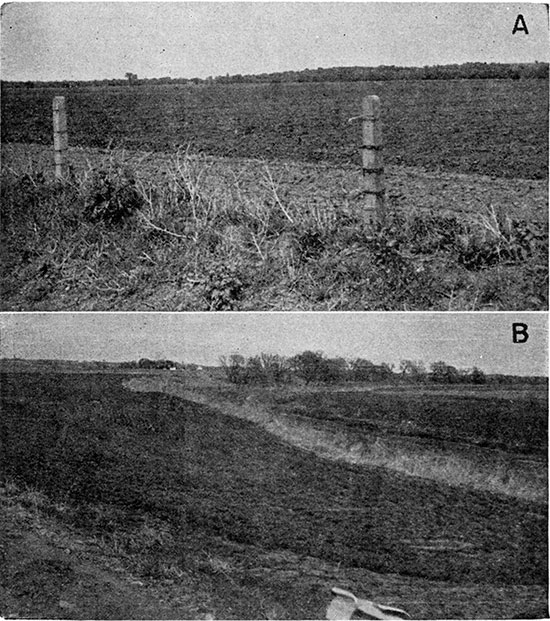
Extensive alluvial deposits that were laid down during the Wisconsinan Stage of the Pleistocene Epoch cover or underlie Kansas River valley, forming a broad level surface a few feet above the present Hood plain. The terrace thus produced was named the Newman Terrace (Davis and Carlson, 1952) from the town of Newman, where a large segment of the terrace surface is unmodified by tributary streams for almost 1 mile north and 2 miles east. The Newman Terrace is widespread throughout this section of the valley, and the broad Hat surfaces in the valleys of Cross Creek, Mill Creek (Pl. 8A), and Mission Creek are continuations of the Newman Terrace surface from Kansas River valley.
Plate 8--A, Newman Terrace surface in Mill Creek valley, looking northeast from a point about half a mile southeast of Maple Hill. B, Scarp between Newman Terrace and flood plain in SW sec. 29, T. 10 S., R. 13 E.
The upper part of the Newman Terrace deposits is silty clay, and the A zone of the soil profile is well developed. Silt and clay of the B zone and C zone are generally gray to gray tan, and they contain many calcium carbonate nodules. Brown stains in the C zone indicate some iron oxidation. Silt and clay grade laterally and vertically into fine sand. The lower part of the terrace deposits is composed of sand and gravel, principally quartz, feldspar, and granite fragments but containing very small quantities of limestone fragments. Because the material is subrounded to rounded, it is judged to have been transported a great distance.
Two distinct soils are included in about 25 feet of silt and clay exposed in a stream cut in the NW NW sec. 33, T. 10 S., R. 12 E. (Pl. 7B). The topsoil is dark-gray silt that has been leached and is friable. This soil is younger than most soils on the Newman Terrace deposits. The other soil (buried) measures 2.2 feet thick and is underlain by about 20 feet of clayey silt that is very similar in texture, color, and other physical appearances to the silt and clay of the upper part of the Newman Terrace deposits.
Several test holes were drilled in the valley to determine the character and thickness of the Newman Terrace deposits. Logs of these test holes are given at the end of this report. Cobbles of limestone, granite, and quartzite were recovered at a depth of about 54 feet, just above bedrock, in the drilling of a water well in the SM SE sec. 1, T. 11 S., R. 13 E. The gravel in the upper part of the well was fairly well sorted and arkosic, as is most of the material in the valley. Gravel in the Newman Terrace deposits is similar to gravel in the lower part of the Buck Creek Terrace deposits.
The Newman Terrace deposits range in thickness from about 37 feet in well 10-13-30cc to about 90 feet in well 10-10-3db, being thickest, as a general rule, north of Kansas River. The part that comprises the sand and gravel ranges in thickness from 7 to 60 feet.
The Newman Terrace deposits provide large supplies of ground water in the area. In general, the wider the valley and the thicker the deposits, the more satisfactory the water supply will be. The coarse gravels are very permeable and are excellent aquifers. Water temperature is about 60°F, varying little except in wells near the river where seasonal infiltration of surface waters may cause fluctuation. Several new irrigation wells have been drilled in the Newman Terrace deposits; the yields range from 500 to 1,500 gpm. Specific capacities of some wells were determined and are given in Table 7.
Late Wisconsinan and Recent Alluvium
The alluvium shown on Plate 1 is late Wisconsinan and Recent in age and is the Hood plain of Kansas River. In most places the alluvium is separated from the Newman Terrace by a scarp 4 to 8 feet high (Pl. 8B). In general, the alluvium is more extensive on the north side of Kansas River.
The alluvium is very sandy in the upper part in contrast to the Newman Terrace deposits. The lower part is generally coarse sand and gravel similar to that of the Newman Terrace deposits. The soil profile is very poorly developed on sandy parent material. Some alluvium was deposited by the 1951 Hood, which over large areas covered or destroyed the soil that had developed; hence an A zone of 0.5 foot is about the thickest that can be observed. Material below the A zone is very fine, silty tan sand, which in many places contains disseminated carbonaceous material. Many of the meander scars contain blue or dark-gray clay, which is impermeable and causes water to collect and remain in the scars for a considerable period of time. Such clay deposits have been referred to as clay plugs and are characteristic of back swamp Hood deposits.
Test hole 11-14-20bc, just west of Valencia on the south side of the river, penetrated only 18.5 feet of alluvium. Test hole 10-13-31cd penetrated 41 feet of sand and gravel. In test hole 9-11-31dc, near the junction of Kansas River and Vermillion Creek, the alluvium is 50 feet thick. The upper 10 feet consists of silt and clay, and the lower 40 feet consists of fine to coarse sand and medium gravel.
Many wells produce water from the sand and gravel of the alluvium (Table 7). The water table is near the surface and wells commonly are constructed by au gering a hole to the water table and then driving a sand point into the saturated sediments. Many wells are of this type and are satisfactory for domestic and stock use. Hydrologic properties of these sediments are similar to those of the Wisconsinan Terrace deposits. Irrigation well 10-10-14bd, drilled in 1955, penetrated 46 feet of alluvium, 26 feet of which was saturated. After the well had been pumped at 300 gpm for 15 minutes, the drawdown was 2 feet; hence the specific capacity was 150 gpm per foot of drawdown.
Recent Dune Sand
There is active shifting dune sand in one locality in Kansas River valley. The dune tract parallels the river on the north side southwest of St. Marys and has a hummocky relief of 5 to 10 feet. The dunes are composed of light-gray to tan very fine quartz and feldspar sand of uniform size and some silt and clay. The dune sand is thin and lies on the surface of the present Hood plain, above the water table.
Prev Page--Geography || Next Page--Geomorphology
Kansas Geological Survey, Geology
Placed on web June 16, 2014; originally published March 1959.
Comments to webadmin@kgs.ku.edu
The URL for this page is http://www.kgs.ku.edu/Publications/Bulletins/135/04_geol.html