Kansas Geological Survey, Bulletin 134, Part 5, originally published in 1959
Prev Page--Introduction and Cherokee coal-bearing area
The Mulky coal is named after the town of Mulky, Lafayette County, Missouri, where it is mined. Originally, the Mulky coal was known in Kansas as the Osage and also the Fort Scott coal. Other names applied to the coal include: Fort Scott Red, Red, Rusty, Bunker Hill, Mound, Hilltop, and Sunshine. Hinds (1912, p. 16) thought the Mulky coal of Kansas to be stratigraphically the equivalent of the Lexington coal of Missouri and the Mystic coal of Appanoose and Wayne counties, Iowa. The Lexington coal of Missouri is now known, however, to occur in the Labette, which is stratigraphically higher than the Cherokee, in which the Mulky coal occurs. Greene and Pond (1926, p. 54) later correlated the Mulky coal of Kansas with the Mulky coal of Lafayette and Saline counties and the Macon City coal of Macon County, Missouri.
The Mulky coal is coextensive with the outcrop of the Blackjack Creek Limestone in southeastern Bourbon County and in northeastern Crawford County north of Mulberry and Arma and generally westward for a distance of several miles on U. S. Highway 69 (Pl. 1). Between Arma and Girard, which is 7 miles west of U. S. Highway 69 and 2 miles south of Arma, the coal is discontinuous (Pierce and Courtier, 1937a, p. 78). In general the coal is absent south and west of Arma. At places, however, its horizon is indicated by a black smut or featheredge of black carbonaceous matter.
The Mulky coal is 32 to 60 inches below the Blackjack Creek Limestone member of the Fort Scott Limestone and directly below the Excello Shale (Fig. 4, 5). As now defined (Searight and others, 1953; Howe, 1956, p. 84, 87) the Mulky coal is the uppermost unit of the Mulky Formation, Cabaniss Subgroup.
Figure 4--Stratigraphic sections showing position and thickness of Mulky coal and its relation to adjacent rocks in R. 24 E., Bourbon and Crawford counties, Kansas.
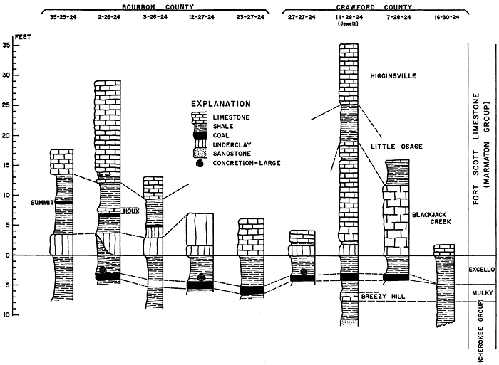
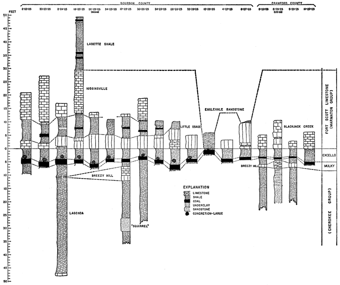
Figure 5--Stratigraphic sections showing position and thickness of Mulky coal and its relation to adjacent rocks in R. 25 E., Bourbon and Crawford counties, Kansas.
Where seen in outcrops the Mulky coal ranges in thickness from a featheredge to 22 inches. The coal thickens northward from Arma and Mulberry in Crawford County to Fort Scott in Bourbon County. Where mined at Breezy Hill southwest of Mulberry, Crawford County, the Mulky coal has a maximum thickness of 12 inches. At most places in the southern part of the mining area in northeastern Crawford County the Mulky coal is 7 to 8 inches thick. Around Fort Scott in Bourbon County the coal is 13 to 19 inches thick, and northeast of Hammond in Bourbon County the coal measures 22 inches thick.
The rock overlying the Mulky coal is the black, blocky to fissile, phosphatic-nodule-bearing shale of the Excello. Almost everywhere that the coal has been mined, large black spherical concretions of dense limestone rest directly on the coal or lie a short distance above it (Pl. 4A).
At several places, as at the north end of the outlier in the NE sec. 23, T. 26 S., R. 25 E., in the NE corner sec. 27, T. 26 S., R. 25 E., in the SE sec. 33, T. 26 S., R. 25 E., in the NE corner SW sec. 5, T. 27 S., R. 25 E., in the NE corner NW sec. 8, T. 27 S., R. 25 E., and in the NW and SW sec. 9, T. 27 S., R. 25 E., all in Bourbon County, and in the Englevale area in Crawford County, the coal is overlain directly by the Englevale Sandstone or a few inches of Excello Shale.
The Mulky coal is classified as bituminous coal of high volatile A to B rank. The unweathered coal is jet black, bright, shiny, brittle, and moderately hard, and occurs as a single bed or seam. In general, the coal is free of clay, shale, or dirt impurities. Close inspection reveals that the coal is laminated or finely stratified. A few thin vertical cracks filled with coal and calcite containing traces of pyrite traverse the seam. Where mined the coal ranges from 7 to 22 inches in thickness. In strip mining, seldom is more than 10 feet of overburden removed. The depth to the coal is dependent upon the dip of the strata, which in Bourbon and Cherokee counties varies from place to place in amount and also in direction. The prevailing regional dip is to the northwest, but there are many deviations in the direction.
Proximate analyses presented in Table 3 show that the Mulky coal compares very favorably with other Kansas coals in Btu content and in the low percentage of ash.
Table 3--Proximate analyses, sulfur content, and heating value of Mulky coal, Bourbon County, Kansas. (Analyses by State Geological Survey of Kansas.)
| Sample no. |
Mine | Location | Analyses, percent | Heating value, Btu | |||||
|---|---|---|---|---|---|---|---|---|---|
| Moisture | Volatile matter |
Fixed carbon |
Ash | Sulfur | Moisture free |
Moisture and ash free |
|||
| 1 | NW 34-25-25 | 1.47 | 35.00 | 53.55 | 9.98 | 3.73 | 13,073 | 14,763 | |
| 2 | Fort Scott Hydraulic Cement Co. |
NW 19-25-25 | 1.10 | 31.19 | 43.47 | 24.24 | 5.78 | 10,731 | 14,375 |
| 3 | Pelett | NE 33-26-25 | 1.00 | 36.29 | 52.48 | 10.23 | 5.95 | 13,046 | 14,696 |
Although the Mulky coal has been mined for many years, being probably the first commercially mined coal seam in the state, a relatively small quantity of coal has actually been mined. The small tonnage mined is explained by the fact that the coal seam is thin (less than 2 feet) and the overburden, except for 3 to 5 feet of soft Excello Shale, consists of resistant, massive Blackjack Creek Limestone commonly 3 to 5 feet thick. Furthermore, at the time the Mulky coal was first mined, mining machinery capable of removing the overburden had not been developed. After the discovery of thicker and lower coal beds farther south, mining of the thin Mulky coal was almost abandoned in favor of the more profitable, thicker coals of southern Bourbon County and Crawford and Cherokee counties.
All Mulky coal mines follow the irregular escarpment of the Fort Scott Limestone. The coal was extracted either by drifting or strip-mining methods. Hundreds of drift or slope mines puncture the escarpment of the Blackjack Creek Limestone in the valley of Marmaton River from Fort Scott eastward to the Kansas-Missouri line. These mines were tunnels dug in the coal bed at right angles to the line of outcrop. The tunnel mouth or entry was usually just large enough for a person to enter the mine. Most of these mines extended into the hillside only a short distance, probably no more than 300 feet for most. Mine entries are spaced at various distances, some less than 100 feet apart, others several hundred feet. Usually where one drift or slope mine was seen, several others were found close by.
In the early days there was no system in mining the Mulky coal seam. "Each man mines under any system most convenient whereby he can produce the most coal. They drift under the hill until such time as it becomes impossible for them to mine any longer for want of air, as they have no system of ventilation in the majority of drifts. Having no boss or superintendent, the mining laws are disregarded and when requested to comply with the laws they abandon many of the drifts and commence operation in some other convenient place. The greater number of the mines are operated only in autumn and winter and employ from 1 to 6 miners, who lease the mines from the owners of the land at 1 cent per bushel royalty. There are many farmers who strip coal in winter and haul the same to Fort Scott. They keep no record of the amount produced. The selling price of strip coal if delivered is from 7 to 10 cents per bushel in summer and from 8 to 12 cents in the winter. The average stripping in the Fort Scott coal pits is 10 feet. The thickness of vein in stripbanks coal runs from 12 to 20 inches. The coal is of good quality, and is known as the 'Fort Scott red coal'. Mining around Fort Scott is conducted in a very careless manner. The owners of the land permit anyone who is willing to pay the royalty to go and dig for a few months in the winter. Having no regular system, they try to produce all the coal possible, and take very little precautions as to safety. Many of the so-called operators have little, if any, experience in mining" (Gallagher, 1894. p. 2).
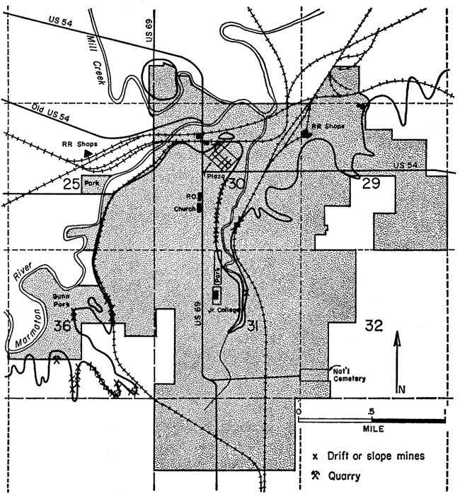
"Most of the coal mined is sold in Fort Scott for domestic purposes at an average price of 7 cents per bushel. Those who employ miners pay 4 1/2 cents per bushel for all coal mined" (Gallagher, 1895, p. 9). Royalty paid to the landowner was 1 cent per bushel for all coal mined. All of the drift or slope mines are now abandoned and are full of water, caved in, or clogged with rocky debris. Some of the larger underground mines, especially those within the city limits of Fort Scott and in the vicinity (Fig. 6), were better developed than the average "gopher hole" type of the inexperienced farmer or lease miner.
Figure 6--Fort Scott, Bourbon County, Kansas, showing trace of Mulky coal and location of some drift mines. Mulky coal was mined here in 1854 and before.
Although definite and accurate information is not available concerning the better Mulky coal mines, older citizens of Fort Scott acquainted with the former mining activity report that some of the mines extended for considerable distances from the mine portal and had many rooms from which the coal was mined. The system employed was the room and pillar method. Because of the nature and antiquity of the mining, it was impossible to locate all drift or slope mines that must have existed or even to estimate the number of mines. Many of the drift or slope mines, however, can be spotted by their openings, partly clogged portals or entries, trenches, mine debris, and other surface indications. Known slope or drift mines are shown on Plate 1.
All Mulky strip pit mines are within 1/4 mile of the edge of the Fort Scott Limestone escarpment. From Fort Scott in Bourbon County southward to the vicinity of Arma in Crawford County there are relatively few places along the escarpment where the Mulky coal has not been mined by the stripping method. The length of the escarpment face totals roughly 90 miles, 40 miles in Bourbon County and 50 in Crawford County. With few exceptions, as in the Breezy Hill area south of Mulberry in Crawford County and in sec. 28, T. 28. S., R. 25 E., also in Crawford County, and at several places in Bourbon County, all strip pit mines are very narrow, most being less than 100 feet wide. The narrowness of the strip mines is best explained by the fact that the Mulky coal was mined at a very early date, before modern mining machinery and power shovels were available, and also the mines were worked chiefly by inexperienced persons, many of them farmers, who had only slight knowledge of mining and whose horse-drawn equipment and hand tools were unable to cope with the heavy overburden confronting them. The overburden at most strip pits is not more than 10 feet thick, but at least half consists of the massive Blackjack Creek Limestone. Perhaps the most amazing fact concerning the stripping of the Mulky coal in Crawford County is the thinness of the seam mined (7 to 8 inches). The mining of such thin coal was justified by (1) the general absence of timber for fuel in the early days of settlement, (2) the quality of the coal, (3) its abundance, (4) its easy accessibility for mining short distances into the hillsides, (5) the good roof for slope or drift mines provided by the massive Blackjack Creek Limestone, (6) the fact that thicker coal seams in Crawford and Cherokee counties had not been discovered or, when developed later, yielded coal that was expensive to purchase, and (7) the fact that the coal was well adapted to local needs and gave the owners, mainly farmers and leasers, added employment and compensation during the fall and winter months when work was normally slack on the farms.
In the early days of mining, the coal sold for 7 cents per 80-lb bushel or $1.75 per ton and as much as $3.00 per ton delivered during the summer months. In 1906 the same coal commanded a price averaging $5.00 per ton at the mine site, and the same price prevailed in 1958 where the coal was still being mined. All coal sold was and is classified as mine-run or untreated coal. Except for local farm use, mining of the Mulky coal has virtually ceased, that fuel having been supplanted by imported and treated coal and by such other fuels as oil, natural gas, and liquefied petroleum gases. Also, because of the thinness of the coal and the heavy overburden, the Mulky coal cannot compete successfully with thicker, more easily mined coal of other nearby areas.
Production data on the Mulky coal are very incomplete. Almost every coal mine inspector registered complaint in his reports; for example, "It is very difficult to gather the coal statistics of this county [Bourbon], as the coal is produced from strip pits and drifts in and around Fort Scott. Many farmers open a strip pit to get coal for their own use, and then haul and trade the balance off to anyone who will buy it at Fort Scott; and then some man will come along, and drift from the strip pit into the hill and produce a little coal, and sell it to a teamster who will haul it to Fort Scott, and stand around the city scales until they find buyers. The miner pays one cent per bushel royalty for this privilege, and keeps no record of his coal, and in this way about 100 or more mines are producing coal. . . . Many who mine coal one month are doing something else the next, and making it almost impossible to make a record of them" (McGrath, 1898, p. 67).
Statistical records of Mulky coal production were further complicated later as coals other than the Mulky were mined. None of the records differentiate between coals, and because the reported locations of the coal mines are very general it is impossible, for many mines, to know what coal was actually mined and reported. Inasmuch as published reports of production data relative to the Mulky coal are unreliable, the quantity of Mulky coal mined was computed upon the basis of the mapped areal extent of the mined coal as shown on Plate 1, the known or observed thickness of the coal, and a specific gravity of 1.32, equivalent to a weight of 1,800 tons per acre-foot of coal, the standard used by the U. S. Geological Survey, Fuels Branch (Averitt and Berryhill, 1950, p. 13; Averitt, Berryhill, and Taylor, 1953, p. 23). Tonnage of coal mined by underground methods (drift or slope mines) can be estimated only roughly.
Because the strip mines follow more or less continuously the Fort Scott Limestone escarpment, it is impractical to define coal mining districts, hence production data are tabulated by township and range. Total mined Mulky coal, computed and estimated, amounts to 3,582,630 tons, 2,415,360 tons from Bourbon County and 1,167,270 tons from Crawford County. Most of the Mulky coal mined in Bourbon County came from T. 26 S., R. 25 E., whereas the greatest amount of coal mined in Crawford County was obtained in T. 28 S., R. 25 E., where the average thickness of the coal is only 8 inches. Computed and estimated coal production in Bourbon and Crawford counties by township and range is presented in Table 4. The tabulated tonnage of Mulky coal represents a minimum, as undoubtedly numerous drift or slope mines were in existence as early as 1860 but all traces of them are now lost. Such mines within the city limits of Fort Scott are now for the most part forgotten and unknown to the present population of the city, as is indicated by the uncovering in the summer of 1956 of an unrecorded caved-in drift mine several hundred feet east of the Missouri Pacific Railroad depot during excavation of rock at the site of a loading platform.
Table 4--Computed and estimated total Mulky coal production, Bourbon and Crawford counties, Kansas.
| Location | Thickness of coal, inches |
Computed area, acres |
Estimated production, tons | ||||
|---|---|---|---|---|---|---|---|
| County | Township | Range | Surface mines |
Underground mines |
Total | ||
| Bourbon | 23 | 25 | 22 | 53.5 | 176,550 | ||
| 25 | 25 | 16 | 139.3 | 334,320 | |||
| 25 | 24 | 14 | 10.4 | 11,400 | |||
| 26 | 24 | 14 | ? | ? | |||
| 26 | 25 | 14 | 494.1 | 1,037,610 | |||
| 27 | 25 | 10 | 331.6 | 497,400 | |||
| 27 | 24 | 13 | 166.4 | 324,480 | |||
| Total Bourbon County | 1,195.3 | 2,381,760 | 33,600 | 2,415,360 | |||
| Crawford | 27 | 24 | 9 | 190.8 | 257,580 | ||
| 27 | 25 | 12 | 10.0 | 18,000 | |||
| 28 | 25 | 8 | 516.8 | 620,160 | |||
| 28 | 24 | 9 | 147.4 | 189,990 | |||
| 29 | 25 | 12 | 453.0 | 81,540 | |||
| Total Crawford County | 1,318.0 | 1,167,270 | 1,167,270 | ||||
| Total Mulky coal production | 2,513.3 | 3,549,030 | 33,600 | 3,582,630 | |||
Coal reserves in the United States are classified as measured, indicated, and inferred (Averitt and Berryhill, 1950, p. 11; Averitt, Berryhill, and Taylor, 1953, p. 11). Measured coal reserves include any minable coal within a radius of 1/2 mile from a known thickness of coal at an outcrop, in a dug well, or in a mine. Indicated coal is coal believed to be present in an area whose limits are defined by a maximum radius of 2 miles and a minimum radius of 1/2 mile from a known thickness of coal at an outcrop or in a drill hole, deep well, or mine. Inferred coal is coal believed to exist more than 2 miles (but not more than 10 miles) from coal at an outcrop or in a drill hole, deep well, or mine. The inferred coal reserves are those that are believed, on the basis of broad geologic information and regional stratigraphic projection, to underlie a given area (Schoewe, 1946, p. 40; Abernathy, Jewett, and Schoewe, 1947, p. 13).
According to the procedure of the U. S. Geological Survey, the minimum thickness of coal considered in computing bituminous coal reserves is 14 inches (Averitt and Berryhill, 1950, p. 9). As much of the coal mined in Kansas came from seams 1 foot thick, however, the State Geological Survey of Kansas has adopted a minimum thickness of 12 inches (Schoewe, 1955, p. 76, 78). On this basis, Crawford County is virtually without any Mulky coal reserves. The only area in Crawford County that is underlain by measured reserves of Mulky coal is in the Breezy Hill community in sec. 1, 2, 10, and 11, T. 29 S., R. 25 E., south and southwest of Mulberry, where an area of approximately 366 acres is underlain by 12 inches of Mulky coal still unmined. Of the 658,000 tons of measured Mulky coal reserves in this area, 474,100 tons may be classified as recoverable coal. Mulky coal reserves are almost limited to Bourbon County. Because of the linear, widespread, continuous distribution of the Mulky coal mines it is not practical to classify them and their reserve areas into coal-mining districts. For this report, therefore, coal reserves are grouped by township and range.
The total area of 74,472 acres (116.3 square miles) of Mulky coal reserve lands in Bourbon County comprises 20,793 acres (32.49 square miles) of measured coal reserve land and 53,674 acres (83.86 square miles) of indicated coal reserve land. Measured Mulky coal reserves are 46,361,650 tons and indicated coal reserves are 126,416,550 tons, a total of 172,778,200 tons of Mulky coal reserves. Most of the measured Mulky coal reserves in Bourbon County are in T. 25 and 26 S., R. 25 E., where 4,186 acres and 2,897 acres respectively are underlain by 14 inches of coal, and T. 24 S., R. 25 E., where coal 22 inches thick underlies 1,493 acres. Most of the indicated Mulky coal reserves are in T. 26 S., R. 24 E., where 14-inch coal underlies 8,918 acres, and T. 23 and 24 S., R. 25 E., where 22 inches of coal underlies 4,975 and 5,326 acres respectively. Measured and indicated Mulky coal reserves are listed by township and range in Table 5. Table 6 is a summary of measured and indicated Mulky coal reserves arranged by thickness of the coal. Data are too sparse to warrant consideration of inferred coal reserves.
Table 5--Measured and indicated Mulky coal reserves, Bourbon and Crawford counties, Kansas, by township and range. (As of December 31, 1957.)
| Township | Range | Thickness of coal, inches |
Reserves | |||
|---|---|---|---|---|---|---|
| Measured | Indicated | |||||
| Acres | Tons | Acres | Tons | |||
| 23 | 25 | 20 | 168 | 504,000 | 888 | 2,664,000 |
| 22 | 590 | 1,447,000 | 4,975 | 16,417,500 | ||
| Total | 758 | 1,951,000 | 5,863 | 19,081,500 | ||
| 24 | 25 | 18 | 398 | 804,600 | 3,041 | 8,210,700 |
| 22 | 1,493 | 4,926,900 | 5,327 | 17,579,100 | ||
| Total | 1,791 | 5,731,500 | 8,368 | 25,789,800 | ||
| 25 | 25 | 14 | 4,187 | 8,792,700 | 1,858 | 3,901,800 |
| 16 | 1,120 | 2,688,000 | 1,080 | 2,592,000 | ||
| 17 | 320 | 816,000 | 1,950 | 4,972,500 | ||
| 18 | 1,184 | 3,196,800 | 1,250 | 3,375,000 | ||
| Total | 6,811 | 15,493,500 | 6,138 | 14,841,400 | ||
| 25 | 24 | 14 | 676 | 1,419,600 | 4,555 | 9,565,500 |
| 26 | 24 | 14 | 1,840 | 3,864,000 | 8,918 | 18,727,800 |
| 26 | 25 | 12 | 21 | 37,800 | 7,243 | 13,037,400 |
| 14 | 2,897 | 6,083,700 | 5,465 | 11,476,500 | ||
| 15 | 1,971 | 4,434,750 | 935 | 2,103,750 | ||
| Total | 4,889 | 10,556,250 | 13,643 | 26,617,650 | ||
| 27 | 25 | 12 | 1,354 | 2,377,200 | 435 | 783,000 |
| 27 | 24 | 12 | 2,156 | 3,880,800 | 3,613 | 6,503,400 |
| 14 | 518 | 1,087,800 | 2,146 | 4,506,600 | ||
| Total | 2,674 | 4,968,600 | 5,759 | 11,010,000 | ||
| Total Bourbon County | 20,793 | 46,361,650 | 53,679 | 126,416,550 | ||
| 29* | 25 | 12 | 366 | 658,800 | ||
| Grand total | 74,838 acres | 173,437,000 tons | ||||
| *Crawford County; all other reserves are in Bourbon County. | ||||||
Table 6--Summary of measured and indicated Mulky coal reserves, Bourbon and Crawford counties, Kansas, by coal thickness. (As of December 31, 1957.)
| Thickness of coal, inches |
Reserves | |||
|---|---|---|---|---|
| Measured | Indicated | |||
| Acres | Tons | Acres | Tons | |
| 22 | 2,083 | 6,373,900 | 10,302 | 33,996,600 |
| 20 | 168 | 504,000 | 888 | 2,664,000 |
| 18 | 1,482 | 4,001,400 | 4,291 | 11,585,000 |
| 17 | 320 | 816,000 | 1,950 | 4,972,500 |
| 16 | 1,120 | 2,688,000 | 1,080 | 2,592,000 |
| 15 | 1,971 | 4,434,750 | 935 | 2,103,750 |
| 14 | 10,118 | 21,247,800 | 22,942 | 48,178,200 |
| 12 | 3,531 | 6,295,800 | 11,291 | 20,323,800 |
| Total Bourbon County |
20,793 | 46,361,650 | 53,679 | 126,416,550 |
| 12* | 366 | 658,800 | ||
| Grand total | 21,159 | 47,020,450 | 53,679 | 126,416,550 |
| *Crawford County; all other reserves are in Bourbon County. | ||||
The coal reserves listed in Table 5 are original reserves or coal in the ground. In order to be classified as recoverable coal, the coal must be salable. Experience in the Kansas strip-mining industry indicates a normal recovery of 75 percent of the original coal. Recoverable shaft-mined coal is computed on a 50 percent recovery basis. Estimates of recoverable coal in the report apply only to measured coal reserves. These amount to 35,265,338 tons for the Mulky coal as of January 1, 1957 (Table 7). It should be pointed out that although all Mulky coal included in the estimates of reserves is within the depth limits permitted for strippable coal, it is overlain in most places by the entire Fort Scott Limestone (including the Higginsville Limestone member), which were fully developed is 15 to 20 feet thick. Such a thickness of hard rock that is not easily removable, coupled with the thinness of the Mulky coal, may preclude the mining of the coal under present economic conditions, although the coal is within reach of the shovel. Furthermore, it should be pointed out that some of the easily obtainable coal may be "dead", "rotten", impure, or partly altered, that is, coal that for one reason or another cannot be sold, hence not "recoverable" coal. Obviously, estimates of recoverable coal must change from time to time, depending upon annual production, economic conditions, and advances in coal technology, factors that one cannot foresee or predict for the future.
Table 7--Estimated recoverable measured reserves of Mulky coal in Bourbon and Crawford counties, Kansas, by township and range and by coal thickness. (As of January 1, 1957.)
| Location | Thickness of coal, inches |
Recoverable coal, tons |
||
|---|---|---|---|---|
| County | Township | Range | ||
| Bourbon | 23 | 25 | 20 | 378,000 |
| 22 | 1,085,250 | |||
| 24 | 25 | 18 | 603,450 | |
| 22 | 3,695,175 | |||
| 25 | 25 | 14 | 6,594,525 | |
| 16 | 2,016,000 | |||
| 17 | 612,000 | |||
| 18 | 2,397,600 | |||
| 25 | 24 | 14 | 1,064,700 | |
| 26 | 24 | 14 | 2,898,000 | |
| 26 | 25 | 12 | 27,500 | |
| 14 | 4,562,775 | |||
| 15 | 3,326,063 | |||
| 27 | 25 | 12 | 1,782,900 | |
| 27 | 24 | 12 | 2,910,600 | |
| 14 | 815,850 | |||
| Total Bourbon County | 34,771,238 | |||
| Crawford | 29 | 25 | 12 | 494,100 |
| Total | 35,265,338 | |||
Abernathy, G. E. (1936) The Cherokee of southeastern Kansas: Unpublished Ph.D. dissertation, Kansas Univ., p. 1-108.
Abernathy, G. E. (1937) The Cherokee group of southeastern Kansas: Kansas Geol. Soc., Guidebook, Eleventh Ann. Field Conf., p. 18-23, fig. 5, 6.
Abernathy, G. E. (1938) Cyclical sedimentation of the Cherokee: Kansas Acad. Sci., Trans., v. 41, p. 193-197.
Abernathy, G. E. (1944) Mined areas of the Weir-Pittsburg coal bed: Kansas Geol. Survey, Bull. 52, pt. 5, p. 213-228. [available online]
Abernathy, G. E. (1946) Strip-mined areas in the southeastern Kansas coal field: Kansas Geol. Survey, Bull. 64, pt. 4, p. 125-144.
Abernathy, G. E., Jewett, J. M., and Schoewe, W. H. (1947) Coal reserves in Kansas: Kansas Geol. Survey, Bull. 70, pt. 1, p. 1-20. [available online]
Adams, G. I. (1896) A geologic section from Galena to Wellington: Kansas Geol. Survey, v. 1, p. 16-30.
Adams, G. I., Girty, G. H., and White, David (1903) Stratigraphy and paleontology of the Upper Carboniferous rocks of the Kansas section: U. S. Geol. Survey, Bull. 211, p. 1-123.
Averitt, Paul, and Berryhill, L. R. (1950) Coal resources of the United States--a progress report, November 1, 1950: U. S. Geol. Survey, Circ. 94, p. 1-33. [available online]
Averitt, Paul, Berryhill, L. R., and Taylor, D. A. (1953) Coal resources of the United States-a progress report, October 1, 1953: U. S. Geol. Survey, Circ. 293, p. 1-40. [available online]
Bailey, E. H. S. (1889) The composition of Kansas coals: Kansas Acad. Sci., Trans., v. 11, p. 46-49.
Bennett, J. (1896) Geologic cross section along the Missouri Pacific Railways from the state line, Bourbon County, to Yates Center; a geologic section along the Kansas River from Kansas City to McFarland: Kansas Geol. Survey, v. 1, p. 86-98, 107-124.
Blake, L. I. (1889) The evaporative power of Kansas coals: Kansas Acad. Sci., Trans., v. 11, p. 42-46.
Bowsher, A. L., and Jewett, J. M. (1943) Coal resources of the Douglas Group in east-central Kansas: Kansas Geol. Survey, Bull. 46, p. 1-94. [available online]
Brown, Bennett (1896) Eighth annual report of the Inspector of Coal Mines, State of Kansas, for the year ending December 31, 1895, p. 1-213.
Gallagher, A. C. (1894) Sixth annual report of the State Inspector of Coal Mines for the year 1893, p. 1-179.
Gallagher, A. C. (1895) Seventh annual report of the State Inspector of Coal Mines for the year 1894, p. 1-71.
Greene, F. C., and Pond, W. F. (1926) The geology of Vernon County: Missouri Bur. Geol. and Mines, 2d. ser., v. 19, p. 1-152.
Hambleton, W. W. (1953) Petrographic study of southeastern Kansas coals: Kansas Geol. Survey, Bull. 102, pt. 1, p. 1-76. [available online]
Hawn, F. (1866) Report of Major F. Hawn--Linn County, p. 109-111; in, Swallow, G. C., Preliminary report on the Geological Survey of Kansas.
Haworth, Erasmus (1895) The stratigraphy of the Kansas coal measures: Kansas Univ. Quart., v. 3, no. 4, p. 271-290, pl. 20, 21.
Haworth, Erasmus (1895a) The coal fields of Kansas: Kansas Univ. Quart., v. 3, no. 4, p. 297-300, pl. 20, 21.
Haworth, Erasmus (1898) Annual bulletin on the mineral resources of Kansas for 1897: Kansas Univ. Geol. Survey, p. 1-98.
Haworth, Erasmus, and Crane, W. R. (1898) Special report on coal: Kansas Univ. Geol. Survey, v. 3, p. 1-347.
Haworth, Erasmus, and Kirk, M. Z. (1894) A geologic section along the Neosho River from the Mississippian formation of the Indian Territory to White City, Kansas, and along the Cottonwood River from Wyckoff to Peabody: Kansas Univ. Quart., v. 2, p. 104-115.
Hay, Robert (1887) Natural gas in eastern Kansas: Kansas State Bd. Agri., Fifth Bien, Rept., 1885-1886, p. 198-208.
Hay, Robert (1887a) Natural gas in eastern Kansas: Kansas Acad. Sci., Trans., v. 10, p. 57-62.
Hay, Robert (1893) Geology and mineral resources of Kansas: Kansas State Bd. Agri., Eighth Bien. Rept., 1891-1892, pt. 2, p. 99-162.
Hinds, Henry (1912) Coal deposits of Missouri: Missouri Bur. Geol. and Mines, 2d. ser., v. 11, p. 1-503.
Howe, W. B. (1956) Stratigraphy of pre-Marmaton Desmoinesian (Cherokee) rocks in southeastern Kansas: Kansas Geol. Survey, Bull. 123, p. 1-132. [available online]
Jewett, J. M. (1941) Classification of the Marmaton Group, Pennsylvanian, in Kansas: Kansas Geol. Survey, Bull. 38, pt. 11, p. 285-344. [available online]
Jewett, J. M. (1945) Stratigraphy of the Marmaton Group, Pennsylvanian, in Kansas: Kansas Geol. Survey, Bull. 58, p. 1-148. [available online]
Jewett, J. M., and Schoewe, W. H. (1942) Kansas mineral resources for war-time industries: Kansas Geol. Survey, Bull. 41, pt. 3, p. 69-180.
Landes, K. K. (1937) The southeastern Kansas coal field: Kansas Geol. Soc. Guidebook, Eleventh Ann. Field Conf., p. 93-95, fig. 34.
McGrath, G. T. (1898) Tenth annual report of the Inspector of Coal Mines, State of Kansas, for the year ending December 31, 1897, p. 1-157.
McMillan, N. J. (1956) Petrology of the Nodaway underclay (Pennsylvanian) Kansas: Kansas Geol. Survey, Bull. 119, pt. 6, p. 187-249. [available online]
Malin, James (1950) Grassland historical studies--Natural resources utilization in a background of science and technology, v. 1, Geology and Geography: Lawrence, Kansas, p. 1-377.
Moore, R. C. (1929) Kansas coal fields: U. S. Bur. Mines, Tech. Paper 455, p. 3-7.
Moore, R. C. (1935) Stratigraphic classification of the Pennsylvanian rocks of Kansas: Kansas Geol. Survey, Bull. 22, p. 1-256, [1936]. [available online]
Moore, R. C. (1940) Stratigraphy of Kansas: Oil and Gas Jour., v. 39, p. 73, 74, 90, 91
Moore, R. C., Frye, J. C., and Jewett, J. M. (1944) Tabular description of outcropping rocks in Kansas: Kansas Geol. Survey, Bull. 52, pt. 4, p. 137-212. [available online]
Moore, R. C., and others (1951) The Kansas rock column: Kansas Geol. Survey, Bull. 89, p. 1-132. [available online]
Mudge, B. F. (1866) First annual report on the geology of Kansas: Lawrence, Kansas, p. 1-56.
Mudge, B. F. (1878) Geology of Kansas: Kansas State Bd. Agri., First Bien. Rept., p. 46-88.
Pierce, W. G., and Courtier, W. H. (1935) Englevale channel sandstone of Pennsylvanian age, southeastern Kansas: Am. Assoc. Petroleum Geologists, Bull., v. 19, p. 1061-1068.
Pierce, W. G., and Courtier, W. H. (1937) Rocks and structure of southeastern Kansas: Kansas Geol. Soc., Guidebook, Eleventh Ann. Field Conf., p. 17-18.
Pierce, W. G., and Courtier, W. H. (1937a) Geology and coal resources of the southeastern Kansas coal field in Crawford, Cherokee, and Labette counties: Kansas Geol. Survey, Bull. 24, p. 1-91. [1938]
Saunders, W. H. (1873) Coals of Kansas: Kansas State Bd. Agri., Trans., 1872, p. 387-391.
Saunders, W. H. (1896) Coals of Kansas: Kansas Acad. Sci., Trans., v. 1, p. 30-34.
Searight, W. V., and others (1953) Classification of Desmoinesian (Pennsylvanian) of northern mid-continent: Am Assoc. Petroleum Geologists, Bull., v. 37, p. 2747-2749.
Schoewe, W. H. (1944) Coal resources of the Kansas City Group, Thayer bed, in eastern Kansas: Kansas Geol. Survey, Bull. 52, pt. 3, p. 81-136. [available online]
Schoewe, W. H. (1946) Coal resources of the Wabaunsee Group in eastern Kansas: Kansas Geol. Survey, Bull. 63, p. 1-144. [available online]
Schoewe, W. H. (1949) The geography of Kansas, pt. 3, physical geography: Kansas Acad. Sci., Trans., v. 52, no. 3, p. 261-333.
Schoewe, W. H. (1951) Coal resources of the Permian System in Kansas: Kansas Geol. Survey, Bull. 90, pt. 3, p. 53-68. [available online]
Schoewe, W. H. (1951a) Current coal research--coal geology in Kansas: Econ. Geology, v. 46, p. 852-856.
Schoewe, W. H. (1952) Coal resources of the Cretaceous System (Dakota Formation) in central Kansas: Kansas Geol. Survey, Bull. 96, pt. 2, p. 69-156. [available online]
Schoewe, W. H. (1955) Coal resources of the Marmaton Group in eastern Kansas: Kansas Geol. Survey, Bull. 114, pt. 2, p. 49-112. [available online]
Swallow, G. C. (1866) Preliminary report on the Geological Survey of Kansas: p. 1-122.
Whitla, R. E. (1940) Coal resources of Kansas: post-Cherokee deposits: Kansas Geol. Survey, Bull. 32, p. 1-64. [available online]
Young, C. M., and Allen, H. C. (1925) Kansas coal: Kansas Univ. Bull. 26, no. 5, Engineering Bull. 13, and Chem. Research Div. Bull. 4, p. 1-202.
Prev Page--Introduction and Cherokee coal-bearing area
Kansas Geological Survey, Geology
Placed on web April 21, 2009; originally published in June 1959.
Comments to webadmin@kgs.ku.edu
The URL for this page is http://www.kgs.ku.edu/Publications/Bulletins/134_5/02_mulky.html