![]()
Prev Page--Blaine Formation || Next Page--Easly Creek Shale
Gypsum in the Wellington Formation
At present no mines produce gypsum from the Wellington formation, but gypsum has been mined in the past from the Wellington formation at several places along its outcrop area.
The base of the Wellington, defined as the base of the shale above the top of the Herington limestone by Moore and others (1951), is exposed with almost complete continuity from northern Marshall County to southern Cowley County. The top of the Wellington is exposed only in the southern part of the state. Elsewhere it is covered by Cretaceous and younger sediments.
Gypsum beds genetically related to the Wellington formation are not restricted to the Wellington. There is evidence of gypsum directly below the Herington limestone in some places. These deposits are discussed with the Wellington gypsum deposits because of their close association and because they mark the beginning of conditions that caused deposition of gypsum in the Wellington.
Evidence for Gypsum in the Wellington Formation
There are several different types of evidence for gypsum in the Wellington formation. In addition to the direct evidence of exposures and drill-hole samples, indirect evidence consists of secondary gypsum or gypsite deposits and also the widespread subsidence structure throughout the Wellington outcrop area, which shows that some material, probably gypsum, has been removed by subsurface solution.
Gypsum Outcrops
Gypsum outcrops in the Wellington formation are rare, but some of them do give an indication of the thickness and character of the gypsum. Only the old gypsum-mining area of Saline and Dickinson Counties was thoroughly searched for gypsum outcrops and an attempt made to show them all on the map of the area (Pl. 2B). Gypsum outcrops in other Wellington areas as well as some of those in the old mining area were located from descriptions in the literature or from directions given by local inhabitants.
Most of the outcrops found were in obscure places; therefore, other areas in the Wellington outcrop belt probably contain undiscovered gypsum outcrops. Nevertheless, the old mining area probably contains more gypsum outcrops in the Wellington than any other area of comparable size. These other areas probably are underlain by as much gypsum, but probably erosional conditions are not as favorable for exposure of the gypsum.
Surface Slump Structure Indicating Gypsum
The outcrop area of the lower part of the Wellington formation is marked by surface slump' structure as indicated by the attitude of a sequence of thin limestone beds that dip in the direction of the topographic slopes (Pl. 10A). These limestone beds seem to be the most resistant units in a sequence containing gypsum, limestone, and shale; their presence at the surface, therefore, is an indication of the presence or former presence of gypsum near the surface.
Most of the limestones are tan or gray, soft, thin, regularly bedded, chalky limestone or siltstone. Less common are brown, hard, irregularly bedded limestones containing lenticular voids. One type of limestone may grade laterally into the other.
Plate 10—Limestone beds in Wellington formation. A. Slump structure revealed in limestone beds in road cut in sections 34 and 35, T. 15 S., R. 1 W. B. Plowed field in Wellington outcrop area in southern Dickinson County. Light spots indicate limestone beds. These are the only indication of outcrops in much of the area.
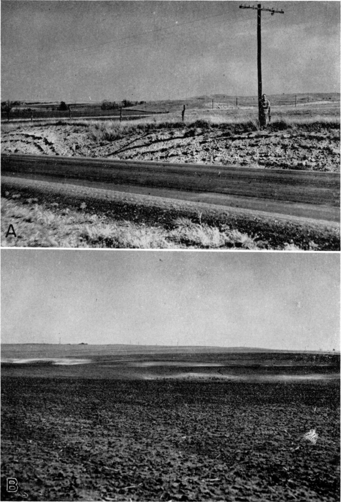
A surface map of Wellington rocks in a part of Saline and Dickinson Counties, where surface and subsurface information could be compared (Pl. 2B), was prepared from field information and from aerial photographs. The Herington limestone is mapped as the base of the Wellington formation. Although Moore and Landes ( 1937) mapped the Hollenberg and Carlton limestones, and Ver Wiebe (1937), in an area farther south, distinguished several additional limestones in the sequence, limestone beds in the lower part of the Wellington are not differentiated here because (1) all are so similar in character as to show no diagnostic feature that would permit recognition in isolated exposures, (2) exposures are poor; in many places the only evidence of the presence of limestone is a difference in color in a plowed field (Pl. 10B), and (3) the topographic position of a given bed varies with the degree of slumping, which adds to the difficulty of identification. The map shows their discontinuous distribution, indirectly indicating the slump structure.
Subsurface Evidence of Gypsum
Subsurface information about the Wellington formation is not readily available. In Kansas most subsurface information comes from the drilling of oil wells. As the Wellington formation is not oil bearing, few samples from the Wellington formation are saved. Electric logs of some exploratory holes drilled through the Wellington formation were made available for this report; the locations are shown on Plate 2B. These electric logs can be compared in order to trace the gypsum beds in the subsurface. Plate 2C is a series of cross sections made from electric logs provided by the Anderson-Prichard Oil Company. This series of cross sections shows that the beds of the Wellington are persistent in the subsurface and that the slumping that is so prevalent at the surface is superficial.
At depths below the influence of ground water, well samples of the Wellington formation are more usable. Well samples from the Wellington and other rocks between the Stone Corral dolomite (stratigraphically above the Wellington) and the Florence limestone (stratigraphically below the Wellington) were examined. Plate 3 shows a series of sample logs from the Wellington formation. The presence of salt casts in the samples is indicated at the right of each log. The wells are located in an approximately east-west line extending westward from the gypsum-mining area in Saline and Dickinson Counties, to show not only the sequence of beds in the Wellington formation and associated strata but also some relation of the surface exposures to the subsurface sequence. These logs, as indicated, are correlated only on the basis of either the Florence or the Stone Corral; nevertheless, a certain sequence is seemingly consistent in each log. The difference from one log to the next may, in part at least, be attributed to the amount of detail preserved in the samples, but other differences are certainly due to the change in the character of the rocks.
The sequence of deposits between the Florence limestone member and the Stone Corral anhydrite is summarized as follows: Above the Florence limestone member, at the base of the sequence, are limestone beds whose total thickness is 200 to 250 feet. These are overlain by 100 to 150 feet of anhydrite beds, overlain in turn by salt that in this area is as much as 250 feet thick. The beds above the salt are predominantly shale, but include some anhydrite or gypsum beds. Where measurable, this shaly zone is 350 to 400 feet thick. The sequence is terminated by the Stone Corral anhydrite where that bed is preserved from erosion. The Wellington formation itself is herein regarded as beginning with the base of the anhydrite beds and extending into the shale above the salt beds.
This description of the Wellington formation does not follow that of Moore and others (1951). They base their description on the Wellington outcrops, and show the formation as chiefly a shale sequence. The Wellington may actually contain proportionately more detrital matter at the surface in its eastern portion along the outcrop than it does farther west in the subsurface. Also, as shown in this report, the evaporite beds in the Wellington crop out in very few places; hence, a distorted impression may have been obtained as to the character of the Wellington. In any case, the Wellington, where studied in its undisturbed condition, seems to follow the sequence outlined above, and is not a predominantly shale sequence.
Gypsum Mines
Several companies operated gypsum mines in Kansas 50 years ago. Most of these mined gypsum from the Wellington formation. Many of these companies changed ownership several times and often changed names; moreover, some of the companies operated more than one mine at the same time or changed their location from time to time so that a single company may have had several locations. Records of the activities of some of these companies are to be found in the publications of the State Geological Survey and of the State Historical Society (Grimsley and Bailey, 1899; Haworth, 1898, 1899, 1900, 1902, 1902a, 1903, and 1904; Moore and Landes, 1926) . Activities during the intervening years are not recorded, however, so information about some of these companies had to be obtained from persons who were familiar with the companies.
The information given here concerning the nature of the deposits, the products, and the types of industry they supported is as complete as possible; a historical report of what happened to one company or another is not attempted.
Gypsite Deposits
One reason for the early activity in mining gypsum from the Wellington formation was the ease of extraction of gypsum earth or gypsite deposits in various places over its outcrop belt. Gypsite is a secondary deposit of gypsum formed by the evaporation of ground water charged with calcium sulfate. This granular to earthy material accumulates at the surface, commonly in low, swampy ground. It dries to a light ash-gray color. It is soft and non coherent, so it can be shoveled into cars and prepared for calcining at less expense than is required in working the solid rock.
By far the greatest number of gypsum mines in Kansas have been operated in deposits of this type; moreover, as far as is known they were limited to the Wellington formation. It is impossible to calculate exactly how much gypsum has been produced from deposits of this type, but it is thought that, owing to the relatively short period of operation of these mines, the figure would be small in comparison to the total amount of gypsum mined in the state.
Near the turn of the century these gypsite beds were important sources of gypsum for construction, and provided local employment for a large number of men. These deposits contained only a small amount of material, however, and were exhausted in a relatively short time. The fact that the material was gray rather than white after calcining possibly was another factor contributing to the abandonment of some of the deposits.
Gypsite deposits are not readily recognizable from a casual examination of the countryside. Even the sites of some of the old pits are now planted to crops or have reverted to swampland. The deposits, before they were mined, had soils developed on top of them and were not distinctive in appearance. It is reported that soil augers were used to prospect for them. Additional prospecting of this sort was not undertaken in connection with this report; only those deposits that are known to have been mined will be discussed here.
Gypsite is still used to make base-coat plaster (Ver Plank, 1952), but most of the Kansas deposits found in the past were exhausted after a few years of mining. Moreover, a plant operating under present conditions would process a larger quantity and would therefore require a much larger gypsite deposit than those previously mined in Kansas. Inasmuch as numerous mines once produced gypsite throughout almost all the Wellington outcrop area, there must have been an extensive search for these deposits. It is probable that most of the deposits have been discovered, and is doubtful that remaining gypsite deposits in Kansas are large enough to support an industry under present conditions.
Individual Deposits
The individual deposits of gypsum and gypsite in the Wellington formation are discussed in part on a geographic basis.
Gypsum in northeastern Clay County
One of the thickest beds of gypsum known to be associated with the Wellington formation is exposed on a steep bank of a creek in the NW SW sec. 19, T. 6 S., R. 4 E., northeastern Clay County. This bed lies directly above the Herington limestone, that is, at the base of the Wellington formation, according to C. K. Bayne and K. L. Walters (personal communication). The base of the bed is covered, but 8 feet of solid gypsum is exposed here.
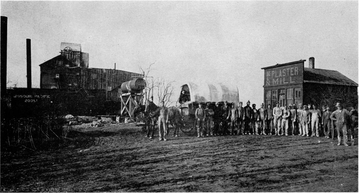
Longford gypsite deposit
Longford, in southwestern Clay County, was once the site of a plant that processed gypsite mined from a nearby deposit. The Longford plant and deposit are typical of the operations of the time; pictures of the pit and plant in operation are available so we have a good idea of the manner in which these gypsite deposits were mined (Pl. 11).
Plate 11—Longford gypsite pit and plaster mill, which operated from 1895 to 1912. (Pictures courtesy of A. Creep, Longford, Kansas). A. Scrapers and disk used in mining gypsite. B. Scraper loading into wagon. C. Plaster mill at Longford.
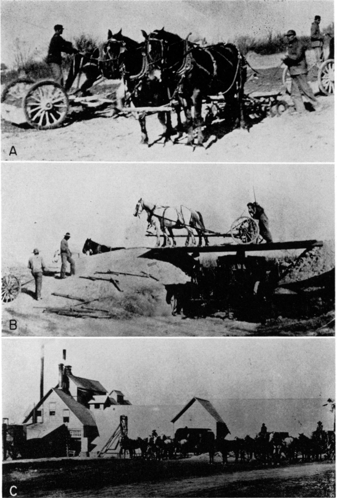
The Longford plant, opened in 1895, operated more or less continuously until it burned in 1903 or 1904. This halted production until a new plant could be built two or three months later. The rebuilt plant operated until 1912, when it was dismantled and moved to Blue Rapids. The plant had three kettles and was reported to have produced as much as 100 tons a day. The product was typically gray.
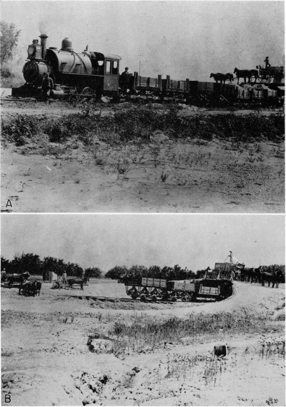
The gypsite deposit was situated in the SW sec. 24, T. 10 S., R. 1 E. Disks were used to loosen the material, then horse-drawn scrapers were used to dig the material out of the pit. At first, wagons were used to haul the material from the pit to the plant, but later a narrow-gage railroad was built (Pl. 13).
Plate 13—Narrow-gage railroad from Longford gypsite pit. (Pictures courtesy of A. Greep, Longford, Kansas). A. Train used to haul gypsite from pit to plant in Longford. B. Wagon loading into train car.
There is a small outcrop of rock gypsum in a plowed field in the NE sec. 25, T. 10 S., R. 1 E., indicating the source of the material in the gypsite deposit. There should be a deposit of rock gypsum close to the surface in the area. Drilling would be required to locate the bed and determine its continuity. The nearest outcrop of Herington limestone (Moore and Landes, 1937) is some distance to the east, suggesting that this gypsum bed is fairly high in the lower Wellington.
Deposit northeast of Solomon
Latta (1949, p. 108-109) records several beds of gypsum in holes drilled northeast of Solomon. He was interested primarily in ground-water conditions in the Smoky Hill valley; consequently most of his holes penetrated only a few feet of bed rock below the alluvium. Those northeast of Solomon were an exception, as more than 80 feet of Wellington formation was drilled in some holes. The following logs are reprinted from his report.
| 67. Sample log of test hole at the SE cor. sec. 34, T. 12 S., R. 1 E., Dickinson County; drilled by the State Geological Survey, 1944. Surface altitude, 1,310.3 feet. | Thickness, feet |
Depth, feet |
||
|---|---|---|---|---|
| Quaternary | ||||
| Dune sand | ||||
| Sand, fine to medium; contains some gray-brown silt | 14 | 14 | ||
| Terrace deposits (Pleistocene) | ||||
| Silt, sandy, mottled tan and gray green; contains some fine gravel in lower part | 10 | 24 | ||
| Permian--Leonardian | ||||
| Wellington formation | ||||
| Shale, soft, gray green, yellow buff, and gray white | 23 | 47 | ||
| Shale, soft, dark gray, and blocky, light-gray and green-gray shale | 23 | 70 | ||
| Shale, soft, light green gray | 10 | 80 | ||
| Clay, soft, green gray, and light- to dark-gray shale | 10 | 90 | ||
| Shale, partly calcareous, light to dark gray and red brown | 10 | 100 | ||
| Gypsum, massive to crystalline, white to transparent, and some gray and red-brown shale | 20 | 120 | ||
| 68. Sample log of test hole at the SW cor. sec. 2, T. 13 S., R. 1 E., Dickinson County; drilled by the State Geological Survey, 1944. Surface altitude, 1,302.7 feet. | Thickness, feet |
Depth, feet |
||
|---|---|---|---|---|
| Quaternary | ||||
| Dune sand | ||||
| Sand, fine to medium, silty, tan and gray | 15 | 15 | ||
| Terrace deposits (Pleistocene) | ||||
| Sand, fine to coarse, and brown silt; contains some fine to medium gravel | 6 | 21 | ||
| Permian--Leonardian | ||||
| Wellington formation | ||||
| Shale, blue gray, gray green, and cream; contains few thin veins of calcite | 59 | 80 | ||
| Shale, dark blue gray | 18 | 98 | ||
| Gypsum (?). No sample, due to loss of circulation. Possibly a solution channel in gypsum | 2 | 100 | ||
| 69. Sample log of test hole in the SW cor. sec. 11, T. 13 S., R. 1 E., Dickinson County; drilled by the State Geological Survey, 1944. Surface altitude, 1,258.8 feet. | Thickness, feet |
Depth, feet |
||
|---|---|---|---|---|
| Quaternary | ||||
| Dune sand | ||||
| Sand, fine to medium, and light-brown silt | 6 | 6 | ||
| Terrace deposits (Pleistocene) | ||||
| Silt, sandy, tan and light gray to gray black | 14 | 20 | ||
| Sand, fine to medium, and clayey gray-green and tan silt | 9 | 29 | ||
| Clay, silty, soft, gray brown to tan; contains some fine to medium sand | 17 | 46 | ||
| Sand, fine to coarse, and fine to medium gravel; contains caliche and many pebbles of sandstone and ironstone in lower part. Thin cemented zones at 56 and 58 feet | 14 | 60 | ||
| Permian--Leonardian | ||||
| Wellington formation | ||||
| Shale, gray green, and soft blue-gray clay | 16 | 76 | ||
| Clay, blue gray and brown, and some blue-gray shale | 12 | 88 | ||
| Gypsum, massive, white and gray, and thin beds of hard, partly calcareous, gray shale | 12 | 100 | ||
| 72. Sample log of test hole in the NW NE SW sec. 23, T. 13 S., R. 1 E., Dickinson County; drilled by the State Geological Survey, 1944. Surface altitude, 1,174.8 feet. | Thickness, feet |
Depth, feet |
||
|---|---|---|---|---|
| Quaternary | ||||
| Dune sand | ||||
| Sand, fine to medium, silty | 20 | 20 | ||
| Terrace deposits (Pleistocene) | ||||
| Silt, sandy, clayey, light brown to light gray | 7 | 27 | ||
| Sand, fine, to medium gravel | 9 | 36 | ||
| Permian--Wolfcampian | ||||
| Shale, red and bright gray green | 4 | 40 | ||
| Shale, red, gray green, and blue gray; containing thin beds of limestone and gypsum | 8 | 48 | ||
| Limestone, hard, white, and hard, white to gray-white shale | 6 | 54 | ||
Gypsum Creek deposit and Solomon mine
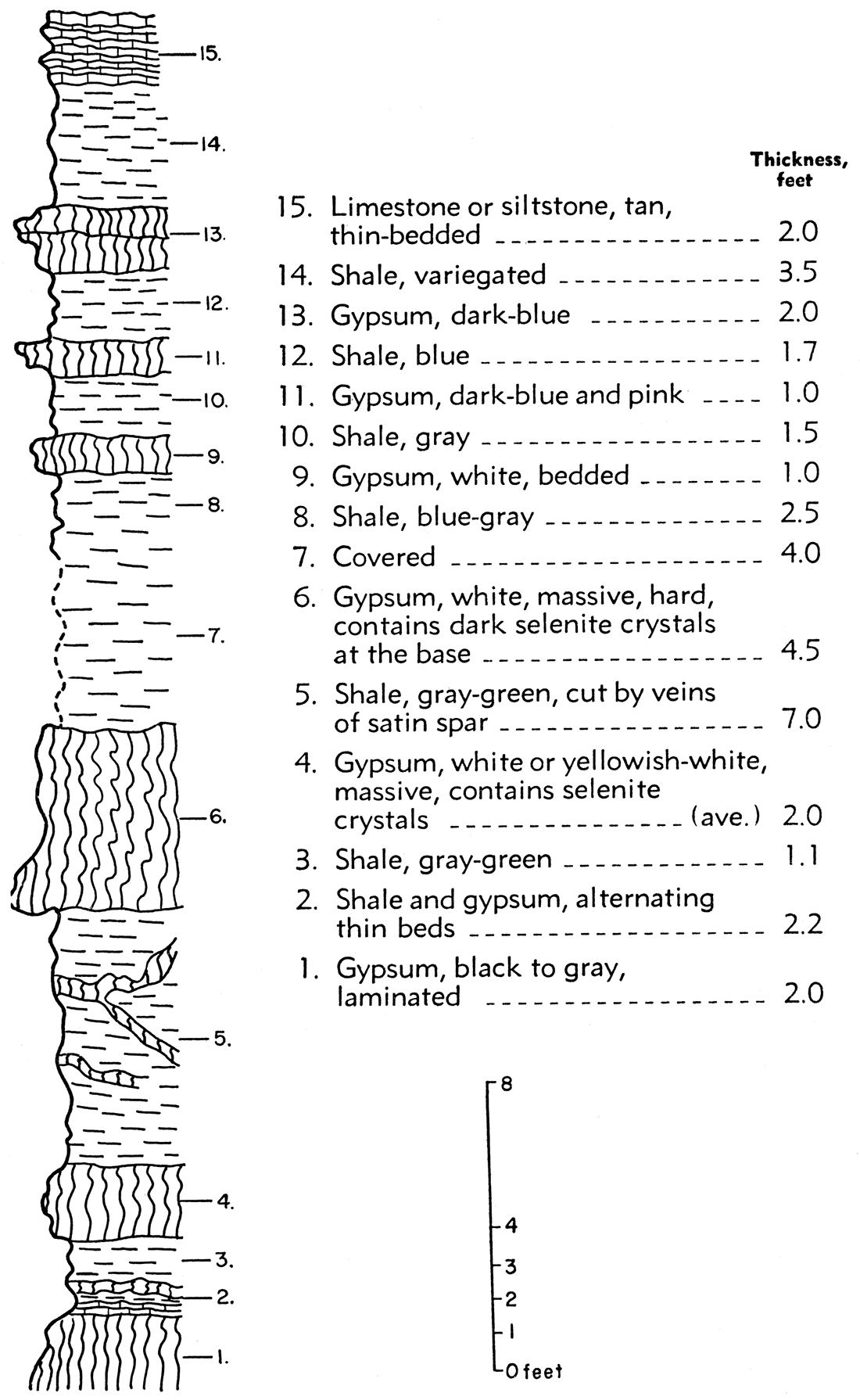
In the SE sec. 3, T. 14 S., R. 1 W., in Saline County on the banks of Gypsum Creek near its junction with Smoky Hill River is the best exposure of gypsum (Pl. 12) in the Wellington formation known to exist. It is one of the few places where a measurable bed of Wellington gypsum crops out. Figure 8 is a columnar section of this outcrop.
Plate 12—Outcrop of gypsum at old Solomon mine on Gypsum Creek in sec. 3, T. 14 S., R. 1 W., Saline County. Prominent white bed is number 4 in Fig. 8.
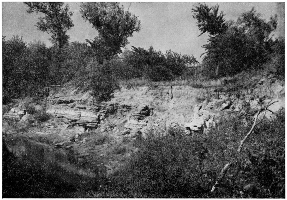
Figure 8—Stratigraphic section of Wellington gypsum exposed on the bank of Gypsum Creek, sec. 3, T. 14 S., R. 1 W. Bed 6 was mined in the Solomon mine.
This outcrop was the site of a gypsum mill and an underground mine known as the Solomon mine. Grimsley and Bailey (1899, p. 58) give the following description of the mine.
"The mine entrance is 15 feet above the water in the creek, and the stratum worked is 5 feet thick, underlaid by about 4 feet of shaly limestone. Below this there is a series of shales with a 3-foot stratum of gypsum. The roof of the mine is a compact, dark shale with a thickness of 3 feet. Above this come 2 1/2 feet of buff shales and 2 feet of gypsum. There is an alternation of shales and gypsum to the top of the hill. The shales with the intercalated gypsum layers are folded and broken. The folds extend down into the mine, causing the shales of the roof to cut out the gypsum in many places, so that the mine has now, in 1898, been abandoned. The dip of the gypsum is north, toward the creek."
The bed mined here was called Solomon gypsum by Grimsley and Bailey.
According to local inhabitants this mine was opened about 1885 or 1886. Plaster from the mill was hauled in wagons approximately 6 miles overland to the railroad at Solomon. This economic disadvantage was offset by the high quality of the product processed from rock gypsum, in comparison to that made from the gypsite obtained from other mines that were operating at that time. The mill also processed gypsum obtained from a few surface quarries in the area. This gypsum seems to have come from a bed approximately 100 feet higher than the bed in the mine. A small community is said to have existed near the site of the mine and the mill. The mill's equipment was moved to Hope about 1900, and the building was destroyed by a tornado in 1949.
Gypsum is also known to occur in beds below the alluvium of the nearby valley of Smoky Hill River stratigraphically below beds exposed on the banks of Gypsum Creek. If the correlations made later in the report are correct, these beds lie somewhat below the Herington limestone and thus below the Wellington formation.
Gypsum near Salina
Gypsum was once mined in the SW sec. 29, T. 14 S., R. 2 W., southeast of Salina. Large blocks of gypsum can still be seen at the quarry site along the west end of the fence line between the north and south halves of the section.
Records show that gypsum may have been quarried on a commercial basis here as early as 1887. Operations are known to have ceased by 1907. Some of the gypsum was used as building stone and some is said to have been made into stucco.
No gypsum outcrops other than the quarried blocks were seen at this locality; slump structure can be observed here, indicating solution of the gypsum in the subsurface.
Hope Mine
The mine that became known as the Hope mine is situated in the SE sec. 32, T. 15 S., R. 3 E., southeastern Dickinson County, and operated in rock gypsum (Pl. 14). More than one bed of gypsum was mined here.
Plate 14—Headframe, office, and employees of old Hope mine. (Picture courtesy of Roy Rubin, Hope, Kansas).
According to Grimsley and Bailey (1899, p. 59-60), gypsum mining west of Hope began in 1887.
"They first used the middle stratum, quarried near the top of the hill, one and one-half miles west of town. [Evidence indicates that quarrying was done on more than one hill.] The rock is about 5 feet thick, and lies 10 feet below a buff, shaly limestone. The gypsum is white and compact in texture, except near the surface, where it is rendered granular and more or less colored as a result of weathering. The satin spar associated with it is of clear white color when viewed from the side, and viewed from above it possesses a cream-white tinge. Over the gypsum is a thin deposit of black, impure, shaly gypsum.
"In 1894 the company abandoned this quarry, and sank a shaft a quarter mile west of the quarry, 80 feet in depth, to the lower stratum, which is nearly 14 feet thick. The rock is white, though much of it is traversed by wavy dark lines which lie close together, giving an appearance somewhat like granite or gneiss, so that plaster made from it is called by the company 'granite cement plaster.' The lower part of the stratum is compact, and contains rounded crystals of selenite, with dark mottled surfaces. It thus bears a close resemblance to the Solomon gypsum, already described, although the crystals are usually large, averaging about two inches by one."
Gypsum City gypsite deposit
The Gypsum City mine operated in a gypsum deposit located in the NE sec. 26, T. 15 S., R. 1 W., Saline County. Grimsley and Bailey (1899, p. 63-64) report:
"The first deposit was discovered in the spring of 1873 near Gypsum City, by Mr. John Tinkler, in running a fire-guard around a field. In 1889 he with others formed the Saline County Plaster Company and built a mill at the edge of town. This was afterwards sold to the Acme Cement Plaster Company, but they no longer use the mill or deposit. In 1892, 7000 tons of plaster were sent from this mill to Chicago for the World's Fair buildings and a medal was awarded the" company in recognition of the qualities of their plaster. It has been used in the government buildings at Forts Riley and Leavenworth, and the product has been shipped to all parts of the United States.
"The Tinkler deposit covers an area of twelve acres, and lies close to the surface with little or no cover. It lies in the valley of a small creek tributary to Gypsum creek. The maximum thickness is 17 feet, while the average is 8. The dirt was hauled in wagons to the mill, one and one-half miles away. The appearance of the deposit resembles very much a fine sand bed or loess formation, and there is a tendency to break in smooth planes or joints. Organic matter occurs through it, and underneath is a layer of clay, and below the clay is a deposit known as the black gypsum, regarded as worthless, Strong springs break through the deposit on the east side. The top of the gypsum earth is 20 feet above the water in Gypsum creek, a quarter of a mile to the west. In a well dug on the hill above the deposit rock gypsum of good quality was struck 30 feet down, or 20 feet below the top of the earth. No trace of gypsum was found in the hills above the earth deposit."
The mill in Gypsum City is reported to have burned in 1890. It was rebuilt and operated until 1896. It is not clear why the mine and mill were shut down, but it is probable that they exhausted either the good material or the easily accessible material, as the Acme Cement Plaster Company had operations elsewhere at the time and seemingly needed more deposits.
Dillon gypsite deposit
The Dillon gypsite deposit is situated in the NE sec. 1, T. 16 S., R. 2 E., Dickinson County. It is described by Grimsley and Bailey (1899, p. 64). This deposit resembles that at Gypsum City. It covered at least forty acres in swampy ground, near a small creek. Its greatest thickness was 18 feet. Gypsum rock crops out about 1/4 mile away at nearly the same altitude. The gypsite was worked by plow and scraper, dried for a few days, and loaded into cars and hauled to the mill, one-half mile north. The mill seemingly was opened about 1896 by the Agatite Company, the same company that operated the Longford deposit. The Dillon mill is known to have closed before the Longford mill, some time before 1912.
St. Joe mine
The old mine known as the St. Joe mine is located in the NE sec. 14 and SW sec. 13, T. 16 S., R. 2 E., Dickinson County. A mine and mill operated on this site. The plant ceased operating about 1908. It is not known when it began operation but probably the date was not long before 1899. Both gypsite from a pit and rock gypsum from an underground mine were used. The rock gypsum crops out in a road cut but the mine operated from a shaft started on top of a hill and sunk 80 feet to the gypsum bed. It is reported that the plant shipped out about a carload of plaster a day. Presumably the surface operation is the Aluminite or Aetna property.
Seemingly Grimsley and Bailey (1899, p. 65) do not mention the mining of rock gypsum in their description of the gypsite of the Aluminite or Aetna deposit:
"The cover is 10 feet thick, and the deposit is 5 feet, but near the top is a layer of 20 inches of sand and gypsum, which sets too quickly, and so is thrown out. Gypsum rock is not reported below this, but a heavy deposit is found on the hill about 30 feet above the gypsum earth. The material from this deposit is hauled to the mill close by, and is the property of the Aetna or Aluminite Cement Plaster Company."
Rhodes gypsite deposit
A gypsite mine operated at a place called Rhodes in sec. 3, T. 17 S., R. 2 E., Marion County. Grimsley and Bailey (1899) reported that the deposit was 6 to 10 feet thick and that a bed of rock gypsum lies close to the surface at this point. A mill was built on the site of the mine and operated from about 1892 until 1898. Plaster was hauled from the mill either southwest to Tampa or north to Elmo and was shipped by rail from those places. Rock gypsum from a quarry in the NE sec. 4, T. 16 S., R. 2 K, near Elmo, was also processed at this mill.
Henquenet cave
The Henquenet cave, in the SE sec. 33, T. 16 S., R. 3 E, is formed in gypsum. Grimsley and Bailey (1899, p. 61) describe it:
"The lower 8 feet of the gypsum is veined and spotted, and the polished slabs bear some resemblance to onyx, while the upper 2 feet exposed is fine grained and compact, like alabaster. This layer is covered by 15 feet of shales and 10 feet of the buff shaly limestone. A small stream flows into this cave after heavy rains, and the outlet is not known. This cave is continued eastward for sixty feet as a ravine, with gypsum walls, while the roof has caved in and for a considerable distance has been removed."
Gypsum had been mined at the cave by the U. S. Gypsum Company before the cave was sealed off. In the spring of 1954 it was opened again.
Gypsum near Peabody
Grimsley and Bailey (1899, p. 67) gave the following report on gypsum near Peabody.
"In 1885 the Peerless Cement Plaster Company built a mill on the farm of Mr. Dean, five miles west of Peabody. The mill was in operation about two years and then abandoned and the machinery sold. The rock was hauled from Liberty creek, one and one-half miles north of the mill, from section 34, East Creek township. There were 2 feet of good gypsum covered by 30 feet of dirt and impure rock, and underlaid by clay. The product is said to have been of high grade and was used throughout the neighborhood. A few years ago gypsum earth was discovered in this same area, covering fifteen acres on the Dean and Brown farms, with a maximum thickness of 7 feet."
The first deposit was in sec. 34, T. 21 S., R. 2 E., on what is now known as Doyle Creek. Records show that the Dean farm was located in the SE sec. 10, T. 22 S., R. 2 E., and the Brown farm was in the SW sec. 11, T. 22 S., R. 2 E.
Gypsum near Annelly
Grimsley and Bailey (1899) reported that gypsum of good quality was found in wells at and near Annelly at a depth of about 30 feet. Ver Weibe (1937) designated the gypsum beds at Annelly as a stratigraphic subdivision of the Wellington. He reported three beds of gypsum each 3 feet thick exposed on a high cliff on the west branch of Whitewater River in sec. 15, T. 24 S., R. 2 E. Altogether the sequence measures 13 feet from the top of the top gypsum bed to the bottom of the bottom gypsum bed. He reported that this sequence could be traced for a considerable distance throughout the southern part of its outcrop areas. No detailed work was done on the Wellington formation in this area in connection with this report.
Burns gypsite deposit
Grimsley and Bailey (1899, p. 67-68) reported this of the gypsite deposit near Burns, Kansas.
"Seven and a half miles southwest of Burns, close to Davis creek, in Butler county, Mr. Gottlieb Heller has opened a gypsum earth deposit which will average 6 feet thick over about two acres of land, and a lesser thickness over a much larger area beyond. The deposit is covered by a thin layer of soil, varying from 1 inch to 2 feet in thickness. Where Davis creek cuts through the gypsum the deposit is about 9 feet, and has a jointed structure, breaking out in large blocks. No gypsum rock is found in the region above this gypsum earth deposit, nor is any reported from the wells in that vicinity, so that as far as is known there is none lying below the deposit. It is whiter in color than any of the other deposits known in the state. Under the microscope it is found to be almost entirely composed of minute yet very perfect crystals of gypsum of uniform size. These crystals are more perfect in form than any others which have been examined from the gypsum earth beds.
"A mill of two-kettle capacity has been erected, and began operation with one kettle early in December, 1898, with a prospect of starting the second kettle soon. This mill is erected at Burns, on the El Dorado branch of the Atchison, Topeka, & Santa Fe railway."
The mill at Burns ceased operation in 1904 or 1905. The gypsite pit, near the center of sec. 16, T. 22 S., R. 4 E., lies topographically below the base of the Herington limestone. The source of the gypsite therefore is probably some bed stratigraphically below the Herington (below the base of the Wellington).
Geuda Springs deposit
Grimsley and Bailey (1899, p. 69) describe gypsum beds about four miles northwest of Geuda Springs, Sumner County. Rock gypsum cropped out along the banks of a small stream in the W2 SE sec. 27, T. 33 S., R. 2 E., where some was obtained for the erection of a large business block in Wellington, generally known as the "marble block".
The beds were known to be at least 15 feet thick, but the base was covered by soil. Well drillers who were interviewed by Grimsley reported that in almost every well for miles around they found gypsum 2 to 6 feet thick.
Grimsley and Bailey described a sizable deposit of gypsum here, but no outcrops of gypsum could be found in this area in the summer of 1953; nevertheless throughout the area there are surface indications of slumping.
Mulvane gypsite deposit
A gypsite mill operated at Mulvane briefly. Its raw material was obtained from a deposit in the NE sec. 32, T. 29 S., R. 2 E., described by Grimsley and Bailey (1899, p.68).
"The material covers an unusually large area along a little stream which cuts through the bed of the deposit, exposing it along the banks, where in places it reaches a thickness of 12 feet or more. It has been estimated that there is enough of the material to produce nearly half a million tons of the manufactured plaster. The quality of the gypsum earth compares favorable with that found elsewhere, . . .
"A company has been formed to manufacture the plaster, and mills are in the process of construction which will be in operation by the 1st of January, 1899. . . ."
Haworth (1902a) reported that the mill closed in 1901.
Sumner County
Bass (1929) found the sequence of lower Wellington rocks in Cowley County too poorly exposed at the surface to decipher. He found only 80 feet of Wellington exposed in Cowley County, but included in his report the plotted log of a hole drilled in the southeastern part of Sumner County, which lies to the west of Cowley County. This log, slightly modified, is included in this report to show the nature of the gypsum beds in that area (Fig. 9).
Figure 9—Section of lower part of Wellington formation as recorded in coredrill hole in southeastern Sumner County. Modified from Bass (1929).
Gypsum indicated in Highway Commission drill holes
The State Highway Commission has furnished information about drill holes that have encountered gypsum at various locations. Information from some holes that penetrated gypsum in the Wellington formation is included here.
| Location | Depth, feet |
|---|---|
| Cen. E. line 21-19-2E | 34.6 to 40.0 feet, gypsum; 40.0 to 41.5, gray shale; 41.5 to 43.7, gypsum |
| NW NW 9-20-3E | 38 to 49 feet, interbedded gypsum and shale, 75 percent gypsum |
| SE cor. 29-19-2E Hydraulic St. Crossing of Arkansas River in Wichita |
5 to 12 feet, gypsum 30 to 60 feet, thin gypsum beds [in shale] |
These holes do not reveal any gypsum beds of great thickness, but most of them are fairly shallow or penetrate gypsum lying below alluvium and therefore subject to solution. No attempt was made to correlate the gypsum beds found in these holes except to determine that they occur in the lower Wellington.
Stratigraphic Position of the Gypsum Beds in the Wellington Formation
Relation of Gypsum-Anhydrite Beds to Wellington Salt Beds
Two conflicting opinions have been expressed concerning the stratigraphic relationship of the Wellington gypsum beds to salt beds. One opinion is that the gypsum beds change laterally to salt beds. The other is that the gypsum-anhydrite beds are a separate unit and lie stratigraphically below the salt beds.
Bass (1929, p. 101) has interpreted the gypsum-anhydrite beds as a lateral facies of the same age as the salt beds. He states:
"E. L. Jones, of the Roxana Petroleum Corporation, kindly supplied a few logs typical of the region and called attention to those beds that are particularly persistent throughout extensive areas and to the fact that beds of salt, so characteristic of the Wellington formation in the vicinity of Hutchinson and elsewhere in central Kansas, change laterally southward and eastward to interbedded salt and gypsum and finally to beds of gypsum."
Lee, Leatherock, and Botinelly (1948; p. 111) interpreted the gypsum-anhydrite beds as being separate from and lying below the salt beds. They state:
"The combined thicknesses of the parts of the Wellington above and below the salt lentil are essentially the same as outside the area of salt deposition. The salt therefore accumulated in a basin formed by the downwarping of the nearly flat surface of the 'anhydrite zone'."
Data presented here support the view that the gypsum-anhydrite beds are a stratigraphic unit separate from the salt beds (Pl. 3). Electric logs of the shallow holes in the outcrop area show nearly the same thickness of the gypsum-anhydrite beds as do the sample logs (Pl. 2C). Cross sections of the Wellington shown by Norton (1939), Lee, Leatherock, and Botinelly (1948), and Lee (1949, 1953) further bear out this relationship throughout much of the Wellington in the subsurface.
Correlation of Individual Gypsum Beds
Workers previously have correlated gypsum beds in the Wellington formation on the basis of elevation and lithology. These correlations have value to us today because more information was available at the time the correlations were made than is available now. Much less reliance could be placed on them. however, were it not for the fact that correlation of electric logs (Pl. 2C) demonstrates undisturbed relationship of the beds in the subsurface, in contrast to the local disturbance of outcrops as a result of surface slumping.
Cragin (1896) correlated gypsum beds that cropped out near Salina with gypsum beds at Hope, but Grimsley and Bailey (1899) and Haworth (1920) have mentioned that there are two gypsum beds at Hope that are stratigraphically 100 feet apart and it is not clear to which bed Cragin refers. Cragin's correlation traverses 13 miles from Salina to Solomon and then more than 20 miles to Hope. Cragin states that he used the strike and dip of the beds exposed at Salina to make this correlation; he does not indicate whether or not he used information from the intervening area.
On the basis of the elevation and lithology, Grimsley and Bailey (1899) correlated the bed mined 80 feet below the surface in the Hope mine with the beds cropping at the mouth of Gypsum Creek. At both of these places higher gypsum beds occur also. At the Hope mine these higher beds are at slightly higher elevation than the surface at the old mine shaft. This gypsum was quarried from several pits before the deeper bed was mined. Near the Solomon mine and the mouth of Gypsum Creek a higher bed is exposed in a field in sec. 2, T. 14 S., R. 1 W., less than a mile east of the beds that crop out at Gypsum Creek. If the lower bed at the two places is correlative, it should follow that the higher beds are the same. North of the Solomon mine at Gypsum Creek, however, a bed of gypsum is known to exist below the level of the valley of Smoky Hill River. As the beds at Gypsum Creek crop out at a higher elevation than the valley floor, and the beds in the valley of Smoky Hill River occur below the alluvium, the subsurface beds are an additional series. If the preceding correlation is correct, there is no known counterpart of these additional beds near Hope; moreover, this lower deposit near Gypsum Creek would lie below the Herington limestone. Slumping of the Herington limestone in some places on the outcrop likewise is evidence that it is underlain by gypsum.
If these correlations are correct, the area between Gypsum Creek and the Hope mine should be underlain by beds of gypsum existing in both areas. The gypsum that crops out at the old St. Joe mine in sec. 13, T. 16 S., R. 3 E., seems to correlate with that in the old Hope mine. The lithology is similar to that described by Grimsley and Bailey (1899) and the bed is at the correct elevation. The beds known to be present in the subsurface along the Dickinson-Marion County line correlate, on the basis of their position, with the bed at the surface near the Hope mine, or possibly represent a higher bed.
The individual beds in the area of Gypsum Creek are not as easy to trace. Nevertheless, evidence of gypsum can be found up the valley of Gypsum Creek as far south as the Saline-McPherson County line. The valleys of Holland Creek and Turkey Creek, the two principal tributaries to Smoky Hill River between the two areas of Grimsley and Bailey's correlation, also show evidence of the presence of gypsum, but no correlation of individual beds is possible.
As far west of Gypsum Creek as Salina, where gypsum has been quarried, there are indications in the subsurface of gypsum below the Wellington (and below the thin covering of Dakota formation in some areas), but it is not possible to trace individual beds throughout the area.
The outcrop area of these beds is much broader than that of any of the stratigraphic units of similar thickness below the Wellington, as found farther east in the state. Therefore, either (1) the regional dip of the Wellington beds is less than that of beds underlying it and exposed farther to the east, or (2) the section of beds is thicker than can be accounted for by the correlations made.
Conclusions Regarding Stratigraphy
Surface and shallow subsurface data (outcrops, slump structure, electric logs of shallow holes, and old mines) show that the gypsum beds in this area occur in a zone directly above the Herington limestone, and seem to correlate with the anhydrite zone found in deep holes farther west (Pl. 3), supporting the proposal of Lee, Leatherock, and Botinelly (1948) that the salt section overlies the gypsum and anhydrite zone, rather than being stratigraphically equivalent. The gypsum-anhydrite beds are a definite zone that should be traceable throughout the outcrop area of the Wellington formation, although individual beds of gypsum may not. This zone in the lower Wellington may contain abundant gypsum resources.
Relation of Gypsum to Anhydrite
In Plate 3 it can be seen that the gypsum deposits found in Dickinson and Saline Counties occupy the same stratigraphic position as the anhydrite deposits found below the salt deposits farther west. The regional dip is to the west, hence this calcium sulfate zone is progressively deeper in that direction. This relationship of gypsum to anhydrite could be explained as resulting from the surficial alteration of an anhydrite bed to gypsum, or by original deposition. If gypsum were formed by original deposition in the Wellington formation, however, the possibility still remains that some gypsum was formed by the alteration of anhydrite.Hydration of an Anhydrite Bed
The simplest explanation of the field relationships outlined above is that the gypsum was formed by the alteration of an extensive anhydrite bed. Anhydrite is known to be altered to gypsum in this way (Bailey, 1932; Newland, 1921; Muir, 1934). Other than the field relationship, however, there is little evidence that would support this explanation.
Observations of well samples left much to be desired in determining the origin of the Wellington gypsum. The cuttings are too fine to reveal the genetic relationships between the gypsum and anhydrite, and furthermore, the gypsum in the samples shows signs of being partly dehydrated, either during the drilling process or during the drying of the samples. This dehydration aided in distinguishing gypsum from anhydrite in the samples, but it destroyed the crystalline structure of the gypsum.
The gypsum beds crop out in very few places, but the outcrop at Solomon mine is an excellent exposure of some of the beds, in which their relationship to one another can be observed (Fig. 8, Pl. 12).
Several of the gypsum beds contain large selenite crystals (Pl. 15A), which Grimsley and Bailey (1899) interpreted as being formed by primary deposition. Their evidence that these crystals were formed by original deposition is not conclusive; rather, indications are that the selenite crystals are secondary rather than primary. A polished section of a piece of gypsum from the exposure on Gypsum Creek (Pl. 15A) shows that the selenite crystals cut across the structure in the rock gypsum, indicating that the selenite crystals were formed during recrystallization rather than during original deposition. It cannot be determined whether the recrystallization took place during a change from anhydrite to gypsum or during recrystallization of the gypsum.
Plate 15—Special features in gypsum near Solomon mine. A. Polished surface of piece of gypsum from outcrop at old Solomon mine. Note that crystals cut veinlets, showing that they are secondary and not formed when bed was deposited. B. Crenulated laminae in piece of gypsum from old Solomon mine. Note that crenulated portion lies between relatively straight laminae.
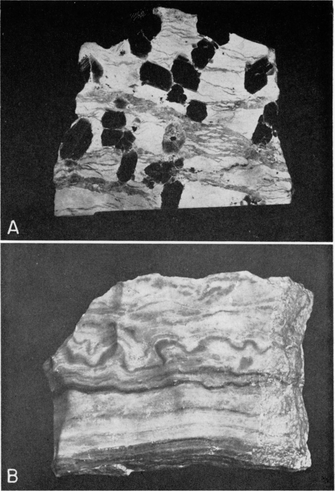
Crenulated gypsum found at the outcrop at Gypsum Creek was first interpreted as having possibly been formed by the expansion of the beds during the formation of gypsum from anhydrite. Closer inspection, however, revealed that not all the laminae are crenulated and that the contorted beds lie between relatively straight beds (Pl. 15B). Such features as these seem more logically interpreted as deformational structures formed penecontemporaneously with the deposition of the calcium sulfate. R. H. King (personal communication) states that such features in the Castile anhydrite beds are still preserved in gypsum formed by hydration of the anhydrite. These features, therefore, do not reveal whether the gypsum was deposited as such or subsequently altered from anhydrite.
Original Deposition of Gypsum
As already discussed, either gypsum or anhydrite may be deposited from an evaporating body of sea water, depending upon the salinity and temperature. On the outcrop the Wellington gypsum beds are interspersed with clastic rocks, showing that there was some fresh water runoff from land that lay east of the present outcrop.
When fresh water flows into a body of salt water, it does not mix immediately. The fresh water has a lower specific gravity and therefore remains as a layer on top of the salt water (Scruton, 1953). Unless there is mechanical mixing, diffusion is the only means by which material in solution may be dispersed into the fresh water, thereby reducing the salinity of the salt water. Wave action is the principal cause of mechanical mixing in an evaporation basin, but it cannot operate below wave base. This means that much of the fresh water entering the basin would merely lie at the surface and evaporate without a chance to decrease salinity near the bottom where the solid calcium sulfate had come to rest. Nevertheless, the possibility remains that in the basin of Wellington evaporite deposition the edge of the basin was receiving enough fresh water to change the salinity of the environment intermittently.
Fresh water added to a basin where gypsum was being deposited should dissolve previously precipitated gypsum until saturation with respect to calcium sulfate is again reached. At this point the water would be capable of precipitating calcium sulfate immediately when evaporating conditions again dominate. If anhydrite is being deposited in the basin, addition of fresh water would dissolve some of the previously precipitated anhydrite. Solution of calcium sulfate would continue until the saturation point was reached. If, however, the addition of fresh water lowered the salinity of the sea water to a point where gypsum rather than anhydrite were the stable form of calcium sulfate, at least part of the anhydrite would be converted to gypsum. Deposition of calcium sulfate (as gypsum) could proceed immediately when evaporating conditions again dominate. It is thus theoretically possible that in Wellington time gypsum was deposited near the edges of the basin and anhydrite in the center.
Conclusions Regarding the Relationship of Gypsum to Anhydrite
The Wellington gypsum beds grade downdip into anhydrite beds. There are two possible explanations for this relationship, (1) the hydration of an anhydrite bed, and (2) original deposition of gypsum as a near-shore facies and anhydrite as a deeper-water facies. The two explanations are not necessarily mutually exclusive. There is no conclusive evidence that gypsum was formed by original deposition; furthermore, this mode of origin requires a much more complicated explanation. Because of the general lack of information about the actual relationships, however, this possibility cannot be eliminated.
Summary
A broad area in the outcrop belt of the Wellington formation is underlain by gypsum, as indicated by slump structures and a few outcrops. Although surface evidence is lacking, subsurface evidence indicates that the anhydrite-gypsum zone of the Wellington formation is stratigraphically directly below the salt, that is, gypsum and salt were deposited successively, not contemporaneously. The anhydrite-gypsum zone seems to be found in all places where the lower part of the Wellington formation is present. Although genetic relationships are not entirely clear, this zone comprises anhydrite at depth and gypsum close to the surface.
Electric logs from a series of shallow drill holes in southeastern Dickinson County indicate that the gypsum beds are persistent, maintaining their stratigraphic position with respect to the underlying limestone. Slump structure seen at the surface does not continue into the subsurface.
Future Possibilities of Gypsum Mining in the Wellington Formation
Gypsum is known to occur throughout much of the Wellington formation, but information about individual beds is scanty, mainly because of lack of outcrops. The depth to which solution has affected these beds also is unknown, and probably is not uniform. The fact that the gypsum crops out in some places should mean that there are other places where gypsum lies just below the surface. On the other hand, drilling by Midwest Research Foundation during the summer of 1953 demonstrated that the gypsum beds are dissected by solution channels at some places where they lie close to the surface; therefore it is difficult to find a large deposit near the surface.
If the gypsum in the Wellington was formed by hydration of an anhydrite bed, the depth to which water penetrates is a limiting factor. A gypsum bed formed by hydration of a bed that was deposited as anhydrite would probably be preserved closer to the surface—it would be less soluble than a bed originally deposited as gypsum because its first reaction to fresh water would be hydration, not solution. If original deposition is the controlling factor, the quantity of gypsum present could be larger (any anhydrite bed within the zone of weathering would still be subject to hydration whether or not it was deposited in association with gypsum).
Additional data on position, thickness, quality, and extent of the individual beds must be obtained before any large-scale exploitation of Wellington gypsum beds can be attempted. Subsurface exploration by drilling in and just west of the Wellington outcrop area probably would be most satisfactory. At the present time the potentialities of this area seem large, inasmuch as the thick section of anhydrite underlying the salt beds may grade laterally into gypsum where subjected to hydration by ground water.
Prev Page--Blaine Formation || Next Page--Easly Creek Shale
Kansas Geological Survey, Geology
Placed on web Feb. 20, 2018; originally published March 21, 1956.
Comments to webadmin@kgs.ku.edu
The URL for this page is http://www.kgs.ku.edu/Publications/Bulletins/133/05_welling.html