![]()
Prev Page--Geology || Next Page--Wellington Formation
Gypsum in the Blaine Formation
The Blaine formation, chiefly gypsum and anhydrite, comprises the Medicine Lodge, Nescatunga, Shimer, and Haskew members (Fig. 3); all but the last of these crop out extensively in south-central Kansas. The gypsum in the Blaine formation, unlike that in other areas in Kansas, is the rock most resistant to erosion at its outcrop, and it forms the "Gypsum Hills" of Kansas and Oklahoma. Plate 1A shows distribution of outcrops of the Blaine formation in Barber, Comanche, and Kiowa Counties. This map is based on field observations and areal photographs. As the gypsum beds form the cap rock on the hills in much of the area, beds could be traced directly on the photographs with a minimum of ground control. Where the gypsum beds could not be mapped from actual exposures or readily projected between exposures, their position was inferred from the topography. The gypsum beds do not crop out continuously; however, they do form an identifiable ledge if not deeply covered. The gypsum outcrops are more prominent, more numerous, and more nearly continuous on the south wall of valleys than on the north wall. In fact, gypsum is not the most resistant bed in the sequence in many places on north walls. Gypsum probably lies close to the surface in some areas not indicated on this map, but there is not enough evidence to warrant mapping it.
In the eastern part of the area the only visible gypsum bed of the Blaine formation is the Medicine Lodge gypsum member. Farther west and south the Nescatunga and Shimer gypsum members appear. In Kansas the total thickness of this part of the Blaine ranges on the outcrop from a featheredge to more than SO feet. Because the outcrop is not continuous, it is impossible to draw an exact line of demarcation between areas of single-bedded gypsum (Medicine Lodge) and multibedded gypsum (Medicine Lodge, Nescatunga, and Shimer), but this dividing line is somewhere near the Barber-Comanche County line. Where the Medicine Lodge and Shimer form separate outcrop patterns the Medicine Lodge was mapped, but at the scale of Plate 1A it would make little difference which bed was mapped.
The quality of the gypsum can not be determined by analyzing samples from the outcrop. Although gypsum is very resistant to erosion in this part of the state, nevertheless it is greatly altered by exposure. Most gypsum outcrops in the area are honeycombed with solution channels and have a superficial crust of secondary gypsum on them. This is due probably to the evaporation of calcium sulfate saturated ground water on the surface of the outcrop. Surface water also has dissolved some gypsum at the outcrop so that the outcrop thickness is not indicative of the true thickness.
Pioneer Mine near Sun City
Gypsum is mined near Sun City, Kansas, from the Medicine Lodge member of the Blaine formation (Fig. 3). The mine, called the Pioneer mine, is operated by the National Gypsum Company, which also operates a gypsum plant in Medicine Lodge, Kansas. In 1950 Medicine Lodge had a population of 2,288 and Sun City a population of 231. Both cities are in Barber County (Pl. 1A, Fig. 1).
Gypsum is mined on the room-and-pillar system. The pillars are 20 feet across. The distance between pillars is 40 feet (60 feet from the center of one pillar to the center of the next). The height of the face generally is about 20 feet (Fig. 4).
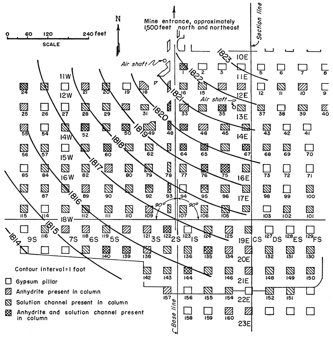
Figure 4—Map of part of the underground workings of the Pioneer mine, Sun City, Kansas, comprising portions of sections 9, 10, 14, and 15, T. 31 S., R. 15 W. Structural contours on mine floor drawn on surface 18 inches above base of Medicine Lodge gypsum. Contour interval 1 foot.
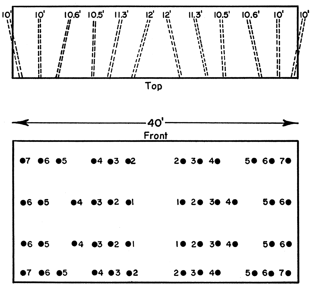
The face is drilled for shooting with a mobile hydraulically operated machine drill that can drill two holes at once and several holes from one position (Pl. 4A). The gypsum is not undercut but is shot off the solid rock. Figure 5 is a diagram of the placement of the holes.
Plate 4—Equipment operating in Pioneer Mine, Sun City. (Pictures courtesy of Homer Venter, National Gypsum Company). A. Machine drill capable of drilling several holes from one position. B. Shuttle cars used to haul gypsum from place of mining to mine trains. C. Mechanical loader used to load gypsum into shuttle cars at place of mining.
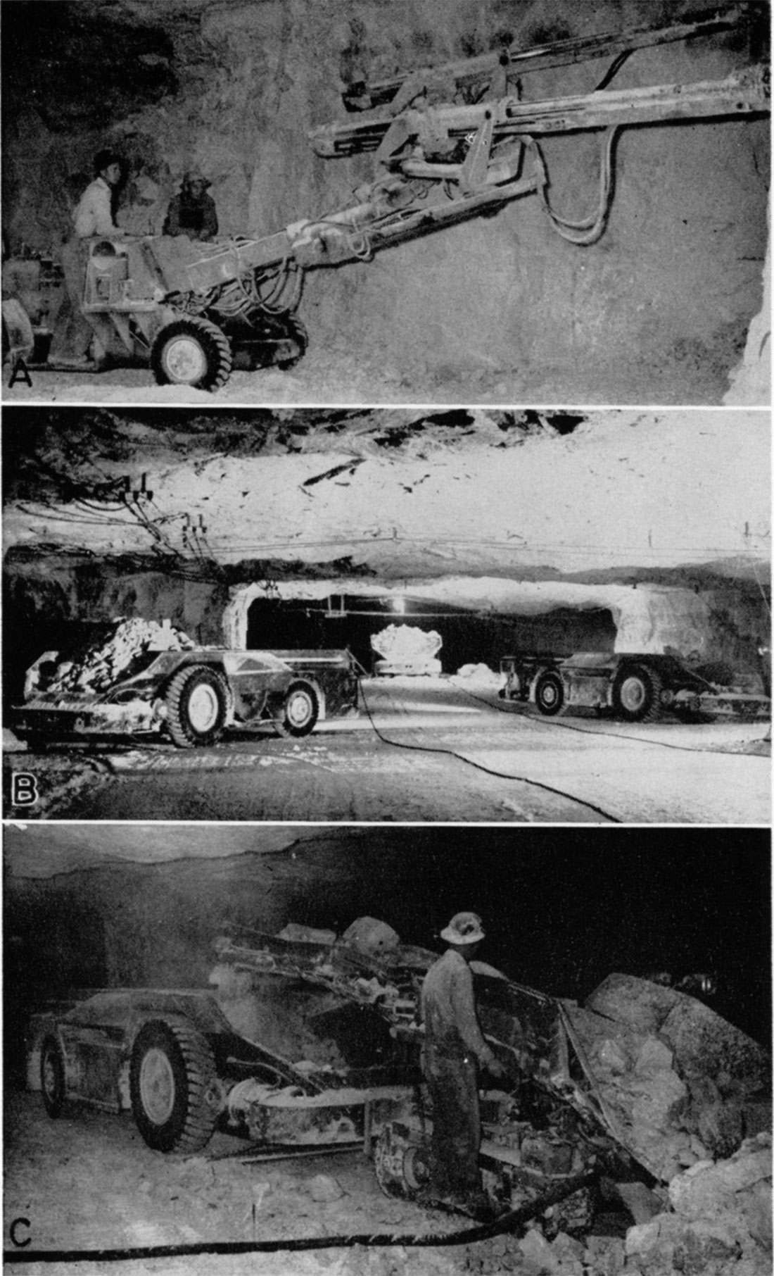
Figure 5—Diagram showing placement of shot holes, Pioneer Mine, Sun City. Holes marked (1) are instantaneous; (2) 25 millisecond delay; (3) 50 millisecond delay; (4) 75 millisecond delay; (5) 100 millisecond delay; (6) 125 millisecond delay; and (7) 175 millisecond delay.
After shooting, the gypsum is loaded into shuttle cars (Pl. 4B) with a mechanical loader (Pl. 4C) and moved to a ramp where it is unloaded from the shuttle car directly into the mine trains. Each shuttle car, which obtains its electrical power from the cable it drags behind it, carries approximately 12 tons of gypsum. A traxcavator is used to clean up the face.
There are 4 mine trains containing 14 cars each. Each car carries approximately 3 tons of gypsum. Two 55-horsepower diesel locomotives operate separately to haul the trains from the loading point in the mine to the crushing plant outside the mine.
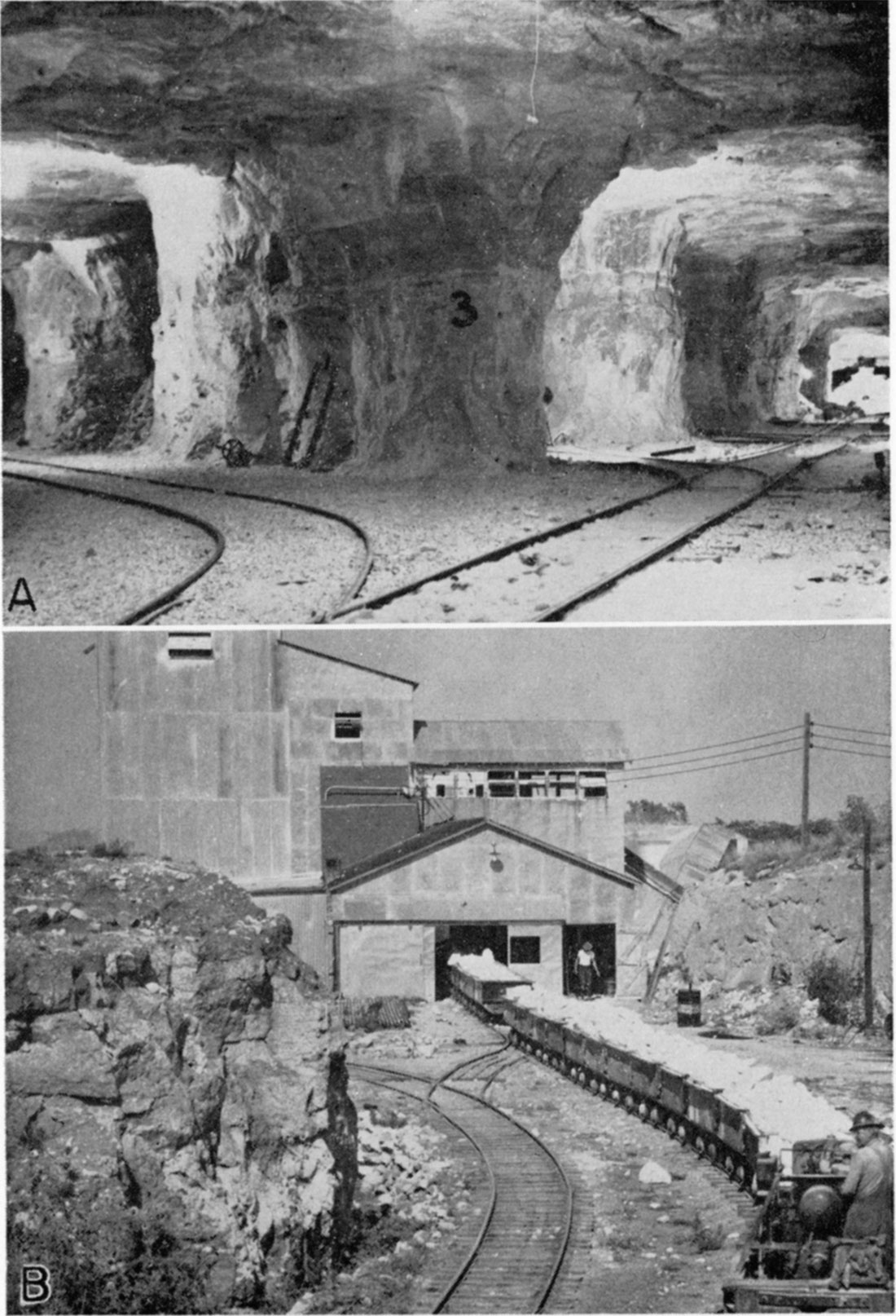
The crushing plant (Pl. 5B) contains a primary and a secondary crusher. The secondary crusher produces pieces of gypsum 1 1/2 inches in size or smaller, which are stored in covered bins for shipment to Medicine Lodge by rail in covered hopper cars.
Plate 5—Pioneer mine near Sun City. (Pictures courtesy of Homer Venter, National Gypsum Company). A. Underground workings. Note anhydrite layer above the number 3 painted on pillar in center of picture. B. Crushing plant at Pioneer mine, and loaded mine train.
National Gypsum Company Plant at Medicine Lodge
The plant at Medicine Lodge (Frontis.) is nationally known for the manufacture of Keene's cement, a gypsum product of high quality. According to Lenhart (1952, p. 152-153), "The chances are most of the decorative work in your local theatre (ornamental figurines, statuettes, etc.) were cast from rock mined in western Kansas." The plant employs both rotary kilns and kettles in the processing of gypsum, and recently expanded its facilities for making wallboard.
The plant's production is primarily Keene's cement and wallboard, but other products produced there include fillers for paper, an ingredient for toothpaste, portland cement retarder, extending agents for paint pigments, industrial plaster, building plaster, gaging and molding plaster, casting plaster, and dental plaster.
The mine near Sun City and the plant at Medicine Lodge are both served by the Atchison, Topeka, and Santa Fe Railway.
History of Gypsum Mining in Barber County
The beginning of gypsum production in Barber County is an interesting story. It was recorded by Haworth (1902a) who wrote:
"The late Prof. Robert Hay wrote a magazine article for Harper's magazine, which was published in June, 1888, in which he described and illustrated the mansard-like hills of Barber County, and gave a good description of the gypsum rock found there in such great quantities. The magazine chanced to fall into the hands of English capitalists, who at that time manufactured what is known in England as Keene's cement, a variety of cement known throughout England and Europe as being superior to anything else of foreign make for use as a high-grade plaster for costly buildings. A delegate was sent to Barber County to investigate the gypsum described by Professor Hay. He found it as described, or rather as one of the company expressed it to the writer, 'the half was not told'. The final outcome was that a branch factory of the Keene Cement Company was established at Medicine Lodge, which began operations in 1891, and has continued ever since, under the management of Mr. Thomas Best, producing a plaster known as Best's Keene's cement, that is generally recognized throughout eastern United States as being superior to the famous Kiege's Windsor, a brand that is considered by architects of Boston and New York fully equal to any imported cement."
According to an unpublished manuscript by G. L. Knight on file at the State Geological Survey of Kansas, Thomas J. Best and his brother William C. Best began manufacturing Keene's cement at Medicine Lodge in 1889. Gypsum was first obtained from quarries a few miles southwest of Medicine Lodge. Quarrying operations were later moved to a place called Kling in northwestern Barber County. Gypsum was later quarried on the south side of the valley of Medicine Lodge River just west and south of Sun City. As these quarries were cut back into the hills the overburden increased so that in 1930 or 1931 the quarrying operations were abandoned and underground mining was begun. In the 1930's the operation was transferred to the National Gypsum Company, which is operating the mine and plant at present.
Geology of the Medicine Lodge Gypsum Deposits
Stratigraphy
The stratigraphy of the Blaine formation, based on the classification of Norton (1939), is shown in Figure 3. The local stratigraphy in the vicinity of the Pioneer mine is shown in Figure 6.
Figure 6—Stratigraphic section of Medicine Lodge gypsum and adjacent beds, near Pioneer mine, Sun City.
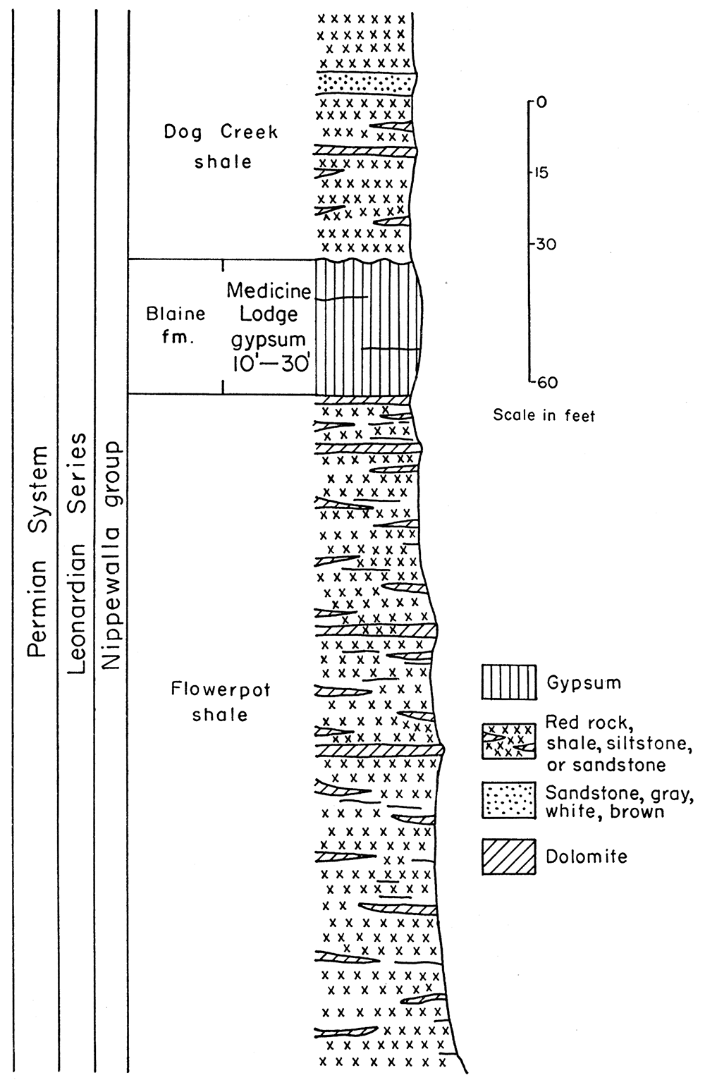
The Flowerpot shale, which is soft, red, and gypsiferous, is the lowermost formation that crops out in the Sun City area. The shale was named by Cragin (1896, p. 25-26) for Flowerpot Mound, southwest of Medicine Lodge; he described the outcrops of the Flowerpot shale as follows:
"The surface is often strewn with fragments of white, pink, red or water-clear satin-spar flecked with green or red clay, and is sometimes also set off with sparkling crystals of selenite.
". . . in canyon walls . . ., the satin-spar forms a network with irregular rhomboidal meshes, . . . warped plates traversing the clay in all directions, . . . sometimes in spacious sublenzitoid compartments subject to partition in various directions by intersecting veins. The seams vary from mere paper-seams to plates several inches in thickness.
"A noticeable and picturesque feature of the Flowerpot clays is the manner ill which their outcrops are carved by the elements. They are, in fact, a theater of rapid erosion, and many weird spectacles present themselves in their relief forms. . . . they are frequently cut into rather steeply sloped faces having that peculiar pattern of sculpture that is best designated as cone-and-gully erosion".
The Flowerpot shale ranges in thickness from 170 to 190 feet; only the upper 145 feet is exposed in the vicinity of the Pioneer mine. The shale rests on the Cedar Hills sandstone, which is not exposed in the area.
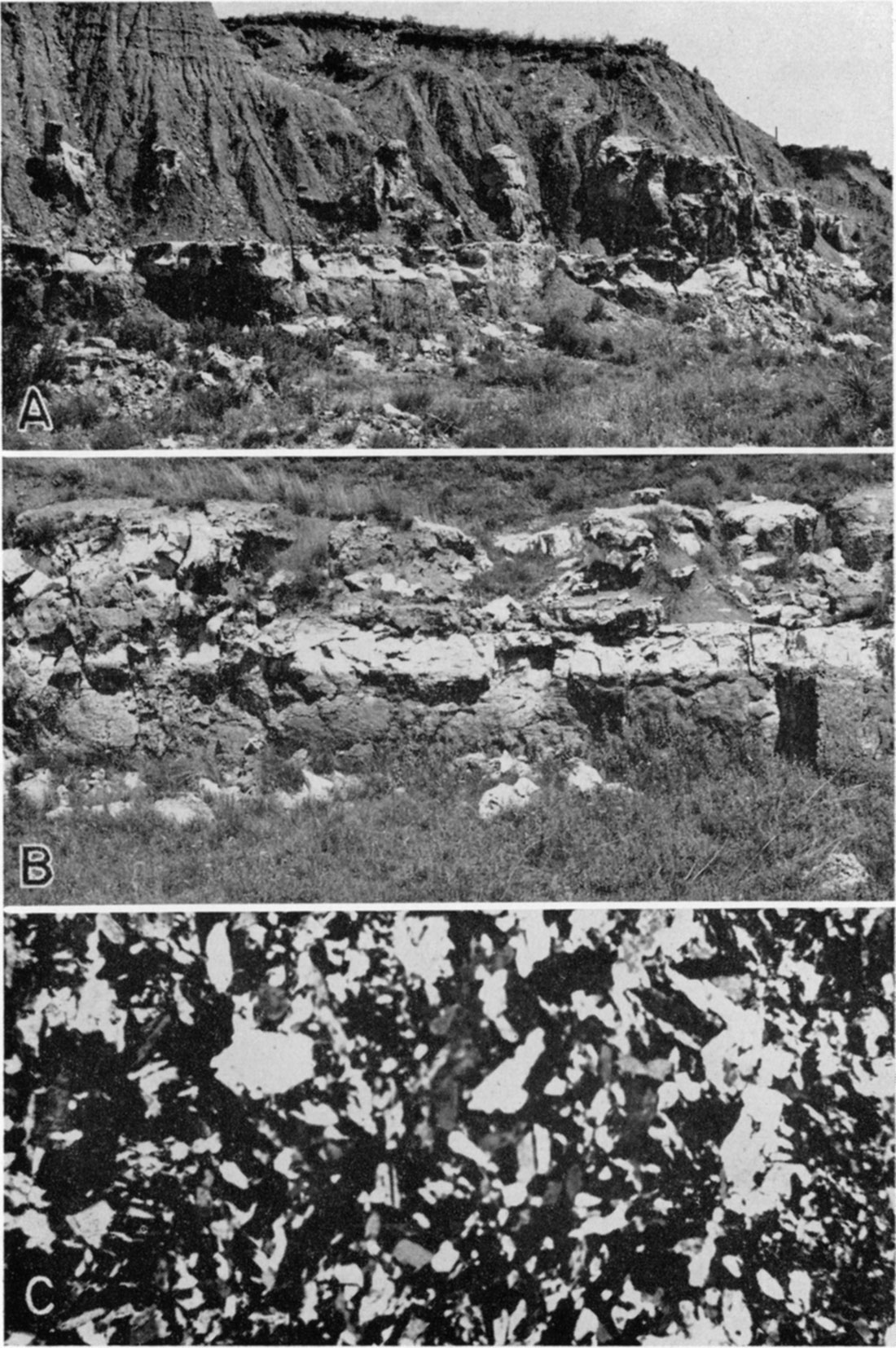
The Blaine formation overlies the Flowerpot shale. The type locality of the Blaine is Salt Creek Canyon near Southard, Blaine County, Oklahoma (Gould, 1905, p. 44). The Blaine formation at the type locality includes four gypsum members. In the vicinity of the Pioneer mine, however, the Medicine Lodge gypsum is the only member of the Blaine present. Farther west in Comanche County additional members are present. The Medicine Lodge gypsum ranges in thickness from 10 to 30 feet; the maximum thickness is exposed in the mine. It is a massive deposit; the lower and upper parts are soft, porous, and smoke-gray, whereas the middle part is harder, more compact, and white. The color variation is well shown in the quarry exposures (Pl. 6B). At the base of the gypsum there is a bed of impure, hard dolomite 6 to 12 inches thick.
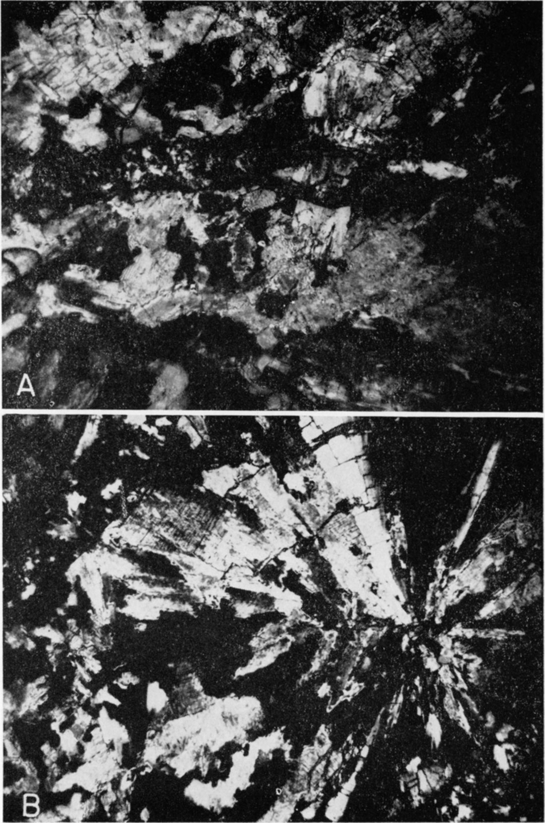
Plate 6—Aspects of the Medicine Lodge gypsum. A. Outcrop of Dog Creek shale and Medicine Lodge gypsum near Sun City. Upper part of gypsum is irregular, owing to solution. The shale has slumped down into the gypsum. B. Exposure of Medicine Lodge gypsum in quarry face near Pioneer mine. Note color variations that give layered appearance. C. Photomicrograph of anhedral crystals of gypsum from lower part of gypsum bed. (Crossed nicols, X 24 [adjusted for web presentation]).
Where the upper gypsum members of the Blaine are missing, as at Sun City, the shale above the Medicine Lodge cannot be distinguished from the Dog Creek shale, so is included therein (Pl. 6A).
The Dog Creek shale overlies the Medicine Lodge gypsum. The type locality is on Dog Creek south of Lake City, Kansas (Norton, 1939, p. 1799). The shale is soft, red, and gypsiferous and includes layers of dolomite and dolomitic sandstone. The maximum thickness is about 53 feet.
Structure
The redbed strata are relatively flat, the regional dip to the southwest being about 11 feet per mile. Structural contours drawn on the base of the Medicine Lodge gypsum (Pl. 1B) show slight irregular dips in several directions. Structural contours drawn on a surface 18 inches above the base of the gypsum in the Pioneer mine (Fig. 4) show a dip to the southwest of 57 feet per mile. North of the mine the gypsum forms a small anticline. The observed structural irregularities may represent initial dips, slump structure, or both.
Field Relationships of Gypsum and Anhydrite
Anhydrite is not common in the surface outcrop of gypsum in the Sun City area. Near the Natural Bridge, 5 miles south of the Pioneer mine, however, the association of gypsum and anhydrite can be observed along the stream bank. The anhydrite occurs as two lenses separated horizontally by massive gypsum, but occupying the same vertical position about 10 feet above the base of the gypsum. Each lens is about 12 feet in length and 12 inches in maximum thickness.
The relationship between gypsum and anhydrite can best be observed underground in the columns and walls of the Pioneer mine. The anhydrite occurs as lenticular deposits ranging in thickness from a fraction of an inch on the outer edges to a maximum of 2 feet in the middle. Where anhydrite is present, it lies about 10 feet above the base of the gypsum. In some places the anhydrite extends the entire width of a 20-foot pillar, but commonly it is not that extensive. Where anhydrite is absent, solution channels generally are present. The solution channels are zones filled with breccia in which the gypsum is crumbly, porous, and sugary, and shows traces of red clay. In many places there is a large flow of water through these channels. Figure 3 shows the location in the Pioneer mine of gypsum, anhydrite, and solution channels, which may occur in the same column; the distribution of the anhydrite is very spotty; columns having solution channels exceed those in which anhydrite alone is present; there is no pattern of anhydrite distribution.
The center part of the gypsum has a layered appearance, owing to the color variations of the gypsum and anhydrite. Plate 5A shows the relationship of gypsum and anhydrite and the color variations.
A thin gray shale seam 1/8 to 1/4 inch thick is present 22 feet above the base of the gypsum, throughout the mine. The upper limit of mining is controlled by this shale seam, along which the gypsum breaks cleanly.
Gypsum also has been produced commercially 8 miles southwest of Medicine Lodge; also 4 miles west of Sun City at a locality called Kling. The thickness of the gypsum at the above localities averages about 8 feet. Anhydrite is not present.
Petrology of Gypsum and Anhydrite
Gypsum and anhydrite from the Pioneer mine were studied to determine their genetic relationships.
Lower part of the gypsum bed (to 10 feet above base)—Megascopically, the gypsum is soft, gray, and crystalline. Anhydrite is absent. Microscopically, the gypsum rock has the following characteristics: 1. The crystals, which are anhedral, range from 0.04 to 5 mm in size (Pl. 6C). 2. A few small anhedral crystals of dolomite and scattered patches of iron oxide are present. 3. Anhydrite is completely absent. 4. The underlying dolomite grades into the gypsum.
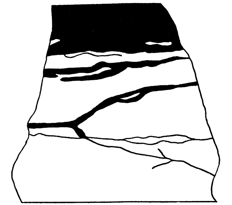
Middle part of the gypsum bed (10 to 22 feet above base)—Megascopically, both gypsum and anhydrite are present. Where anhydrite is present, the gypsum is compact; where anhydrite is absent, the gypsum commonly is porous and sugary. Brecciated zones containing red clay are present. The anhydrite occurs in lenses averaging about 12 feet in length and 1 foot in thickness. The contact between gypsum and anhydrite shows veinlets of gypsum penetrating into the anhydrite. The veinlets commonly surround portions of the anhydrite and most are sub-parallel to the bedding planes of the anhydrite (Fig. 7).
Plate 7—Photomicrographs of gypsum veinlets penetrating anhydrite. A. Sharp-walled irregular veinlets (light) penetrating anhydrite (dark). Note islands of anhydrite within gypsum. (Plane light, X 27 [adjusted for web presentation]). B. Sharp-walled veinlet of gypsum penetrating anhydrite along cleavage planes. Note parallel walls. (Plane light, X 114 [adjusted for web presentation]).
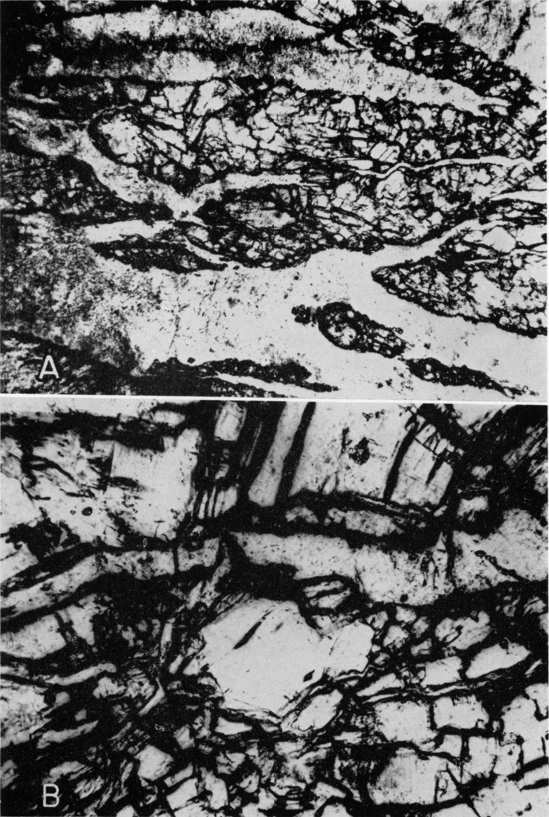
Microscopically, the gypsum and anhydrite have the following characteristics: 1. The gypsum is composed of anhedral crystals ranging from 0.05 to 5 mm in size. 2. Veinlets filled with gypsum extend into the anhydrite. Some of these veinlets are sharp walled, and many have parallel matching walls (Pl. 7 A, B). 3. Radial aggregates of anhydrite crystals are common (Pl. 8A, 9B). 4. Anhydrite crystals cut by gypsum maintain optical continuity (Pl. 9A). 5. The gypsum-anhydrite contact seems gradational at many places (Pl. 8B). 6. Evidence of distortion in the gypsum and anhydrite is lacking.
Plate 8—Photomicrographs of gypsum and anhydrite. A. Radial aggregate of anhydrite. Note gypsum-anhydrite contact in lower right corner. (Plane light, X 24 [adjusted for web presentation]). B. Gradation of anhydrite (A) to gypsum (G). Very irregular contact between anhydrite and gypsum along upper portion of field. Gypsum also penetrates anhydrite as veinlets (Plane light, X 486 [adjusted for web presentation]).
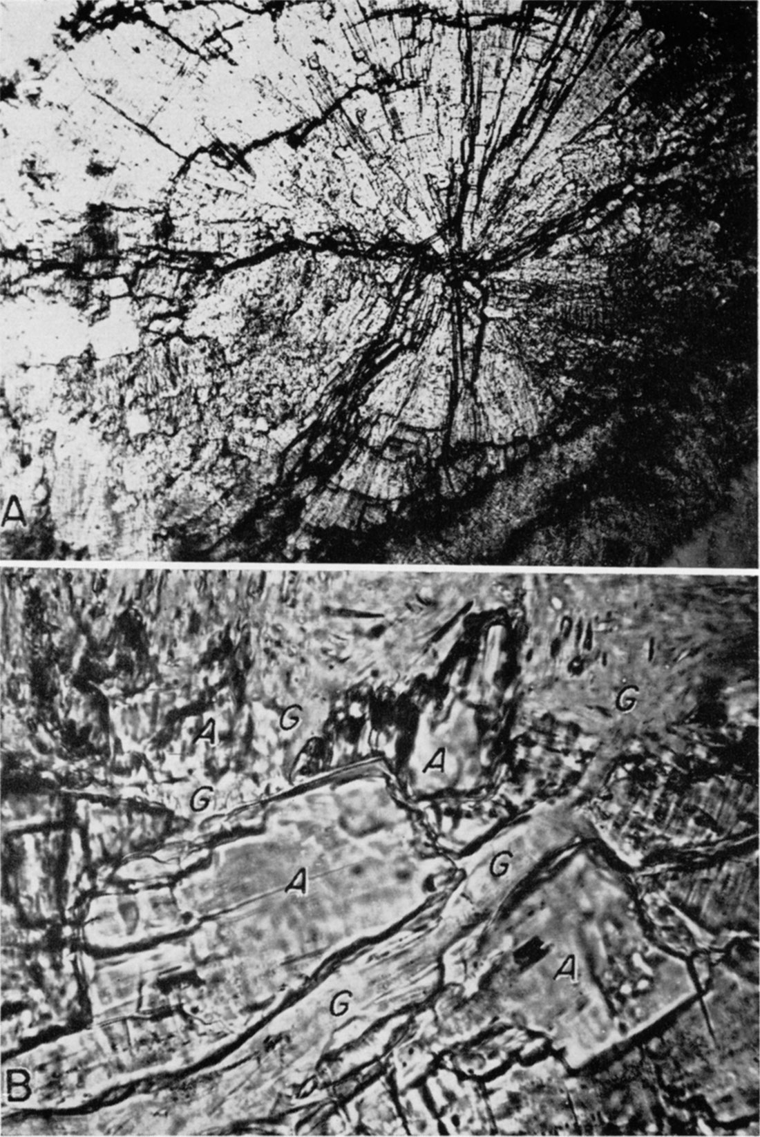
Plate 9—Photomicrographs of gypsum and anhydrite. A. Gypsum veinlet cutting anhydrite crystal (center of field). Veinlet branches to enclose part of anhydrite crystal. Optical continuity is maintained. (Crossed nicols, X 24 [adjusted for web presentation]). B. Radial aggregate of anhydrite (Crossed nicols, X 24 [adjusted for web presentation]).
Upper part of the gypsum bed (22 to 30 feet above base)—Megascopically, the gypsum is soft, gray, and crystalline. A shale seam, 1/8 to 1/4 inch thick, occurs in the mine about 22 feet above the base. The upper surface of the gypsum is irregular.
Figure 7—Sketch showing gypsum veinlets penetrating anhydrite within Medicine Lodge gypsum at contact of gypsum and anhydrite. The gypsum (black) penetrates into the anhydrite (light) as small irregular veinlets, roughly parallel to the contact (X 1.15 [adjusted for web presentation]).
Microscopically, the gypsum rock exhibits much the same characteristics as that in the lower part. Iron oxide is present, but dolomite and anhydrite are absent.
Petrologic Interpretations
Evidence for the hydration of anhydrite to gypsum—Megascopically, solution channels occur at about the same height above the base of the gypsum as the lens-shaped masses of the anhydrite. Hydration of anhydrite to gypsum and subsequent solution of the resulting gypsum may account for solution channels at approximately the same horizon as the anhydrite. The gypsum along the solution channels is brecciated, soft, porous, and sugary in contrast to the compact gypsum found elsewhere. In the solution channels, a thin coating of red clay is present on some of the gypsum fragments. The lenticular shape of the anhydrite likewise may be' an indication of hydration.
Microscopically, the gypsum surrounds aggregates of anhydrite in many thin sections. Many of the aggregates show gradation of anhydrite to gypsum. Thus it seems that in places gypsum is later in origin. The gypsum-anhydrite contact is gradational in many places.
Evidence against hydration of anhydrite to gypsum—Megascopically, the thickness of the bed is the same whether anhydrite is present or not. Theoretically, hydration of anhydrite to gypsum should cause an increase of about 63 percent in volume, and presumably any such increase in volume would cause some local distortion of the bed. No evidence of distortion attributable to expansion was observed in the field, however. The lateral discontinuity of the anhydrite may be the result of lenticular deposition due to local variation in temperature and salinity.
Microscopically, anhydrite is completely absent in the lower and upper parts of the gypsum. It would seem logical that some relics of anhydrite would be present if all the gypsum had formed by hydration. The irregular, sharp, parallel matched walls of numerous gypsum veinlets in the anhydrite denote fracture filling.
Relationship of the gypsum and anhydrite—In view of the above megascopic and microscopic evidence, the following sequence of events may account for the observed relationship between gypsum and anhydrite.
The Medicine Lodge calcium sulfate deposits were formed by the evaporation of saline waters. The sequence of deposition was (a) 10 feet of gypsum, (b) about 2 feet of continuous anhydrite or anhydrite lenses, (c) 18 feet of gypsum. Through some disturbance subsequent to deposition, the gypsum and anhydrite were fractured. Slumping of gypsum along solution channels might account for the fracturing. The fractures served as planes of weakness through which meteoric water penetrated the gypsum and anhydrite. The water, entering the gypsum, took into solution some of the gypsum and continued downward to the anhydrite. As anhydrite is more slowly soluble than gypsum, it is possible that water ponded above the anhydrite bed. Brecciated zones within the Medicine Lodge gypsum occur at about the same horizon as the anhydrite; the porosity of the gypsum, and the presence of red clay along the brecciated zones indicate that these zones probably were formed by solution. The water in contact with the anhydrite may have hydrated part of the anhydrite to gypsum. The solution of gypsum and the hydration of anhydrite probably took place simultaneously, solution of the gypsum perhaps exceeding the hydration of anhydrite. The solution of the gypsum caused a decrease in volume whereas the hydration of anhydrite supposedly caused an increase in volume. In other words, the more rapid solution of gypsum may have provided space for the expansion resulting from hydration of anhydrite to gypsum. This may explain hydration of anhydrite without movement or distortion of the resulting gypsum. Some of the fractures within the anhydrite and gypsum were filled with gypsum veinlets, which have irregular shape and parallel matching walls. Other veinlets show gradation of anhydrite to gypsum, suggesting hydration. With continued simultaneous solution of gypsum and hydration of anhydrite, anhydrite may have been completely removed from parts of the anhydrite beds. The hydration and subsequent solution of the anhydrite may have left lenses of anhydrite and may account for the lateral discontinuity of the anhydrite bed. The gypsum originally taken into solution was partly deposited in fractures in the gypsum formation and partly redeposited in the shale below.
Summary
The Medicine Lodge gypsum member of the Blaine formation (Leonardian) crops out in Barber County, Kansas, and extends westward into Comanche County and southward into Oklahoma. The gypsum ranges in thickness from 10 to 30 feet, the maximum thickness being exposed in the Pioneer mine, Sun City. Anhydrite is exposed at the surface at only a few places in Barber County. In the mine, lenses of anhydrite occur within the gypsum about 10 feet above the base of the gypsum.
The regional dip is about 11 feet per mile to the southwest. Structural contours drawn on the base of the gypsum show slight local irregularities, which may represent initial dips or slump structure.
Where anhydrite is absent in the middle portion of the gypsum in the mine, breccia-filled solution channels generally are present at about the same horizon as the anhydrite. The gypsum in these zones is soft, porous, and sugary. Some red clay is present in the breccia zones. Anhydrite is not present in the lower or upper parts of the gypsum.
Petrographic studies show (1) local gradation of anhydrite to gypsum; (2) filling of fractures in the anhydrite with gypsum; (3) cutting of anhydrite crystals by gypsum without disturbing the optical continuity of the anhydrite; (4) radial aggregates of the anhydrite; (5) gradation of the basal dolomite into the gypsum; (6) localization of dolomite in the lower part of the gypsum; (7) absence of anhydrite in the lower and upper parts of the gypsum; and (8) presence of iron oxide throughout the gypsum.
Field and petrographic studies indicate that both gypsum and anhydrite were original precipitates, part of the anhydrite subsequently hydrating to gypsum.
Prev Page--Geology || Next Page--Wellington Formation
Kansas Geological Survey, Geology
Placed on web Feb. 20, 2018; originally published March 21, 1956.
Comments to webadmin@kgs.ku.edu
The URL for this page is http://www.kgs.ku.edu/Publications/Bulletins/133/04_blaine.html