Kansas Geological Survey, Bulletin 127, part 1, originally published in 1957
Originally published in 1957 as Kansas Geological Survey Bulletin 127, part 1. This is, in general, the original text as published. The information has not been updated. An Acrobat PDF version (4 MB) is also available.
A complete bibliography of 52 published geophysical papers on Kansas is presented along with a brief description of each. The subjects include magnetic, gravity, electrical, and seismic work, but exclude bore-hole investigations and geochemical studies. A review of geophysical exploration in the state for the past 20 years also is presented. Cross reference to the bibliography by subject and county is given.
Geophysics is the study of the physics of the earth and attempts to determine its physical properties, structure, and composition. In practical application, geophysics becomes a tool in prospecting for mineral deposits and geologic structures by surface measurement of magnetic, gravitational, electrical, elastic, and radioactive properties which are influenced by differences in underlying earth materials. Although it has evolved from the practical application of knowledge accumulated by many investigators over a long period of time, geophysics is among the newest branches of applied science. During the past three decades it has become a major tool in man's search for fuels and other raw materials hidden beneath the earth's surface. Geophysical data, however, are only as good as the interpretation placed upon them, and good interpretation has its foundation in the success and failure of previous work. The purpose of this report is to collect the published literature dealing with geophysical activity in Kansas so that it may serve as a useful guide to future geophysical studies in the state.
Much of the geophysical work in Kansas has not been reported in the published literature because the information has potential value to its owner. A summary of exploration activity is included in order to demonstrate the vigor of the geophysical industry and its importance to our search for raw materials.
Reference is made to magnetic, gravity, electrical, seismic, and radioactive studies, but not to bore-hole investigations or geochemical studies.
The first published magnetic studies in Kansas were by the United States Coast and Geodetic Survey; Deel and Howe (1948) tabulated magnetic dip and horizontal intensity values for a station established at Lawrence in 1877. Most importantly, they refer to Coast and Geodetic Survey publications beginning in 1885 which list magnetic data for stations throughout the United States (including 57 stations in Kansas) and summarize these data in magnetic tables and charts. The tabular data give approximate location of each station, date of observation, declination, inclination, and horizontal intensity; four charts show lines of equal declination, inclination, horizontal and vertical intensity, and rate of change of each element. The listed stations provide an excellent control network of absolute magnetic values to which instruments giving relative values may be referred.
Heiland (1929), making reference to magnetic studies in Kansas for exploration purposes, indicated that most of the central and western part of the state had been surveyed with the magnetometer by 1929. At that time, there had been geophysical activity in all but about 29 of the 105 counties. Early studies were concentrated along the Nemaha ridge, other north-south trending anticlines, and; shoestring oil fields. Attempts were made to obtain data on configuration of the Precambrian basement rocks; however, lateral displacement of magnetic anomalies resulting from differences in lithology of basement rocks produced interpretation problems. Particularly cited are the El Dorado field, an anticlinal high in Butler County that is on the flank of a magnetic low, and the Gorham field in Russell County, where change in basement lithology from granite to schist produces anomalous magnetic intensities. Mention also is made of other structural highs that approximately, parallel the Nemaha ridge and can be traced magnetically.
In tracing the development of the Hotchkiss super dip instrument, Stern (1932) cited case histories involving superdip exploration, which include the Bush City shoestring pool in Anderson County. Results indicated that, in places, it was possible to determine location of the sand, but the anomaly is of greater magnitude than could be associated with the sand itself. Seemingly superposition of one anomaly on another produces a magnetic low. Stern suggested that well casing may be the source of the second anomaly and that practicality of the superdip for shoestring exploration would be doubtful because of the detail necessary. Patton (1935) reached similar conclusions in a review paper dealing with geophysical exploration for shoestring sands.
In 1932, Harbaugh announced that a regional vertical intensity magnetic map had been completed for an area in southeastern Kansas and southwestern Missouri. The purpose of the map was to establish, if possible, relationship between zinc-lead ore deposits and magnetic anomalies of the Tri-State district.
Jenny (1932) discussed the use of magnetic vectors in interpreting local and regional geologic information. The vectors were computed from values of declination and of horizontal and vertical intensity obtained at Coast and Geodetic Survey stations in Louisiana, Texas, Arkansas, Oklahoma, Kansas, Mississippi, Alabama, and California. He concluded from this study that magnetic lows correspond with structural highs at some places in central and western Kansas, and that magnetic lows coincide with structural lows and magnetic highs with structural highs in eastern Kansas. Jenny made particular effort to explain magnetic anomalies associated with the Nemaha granite ridge. Because erosion removed pre-Pennsylvanian rocks at the north end of the ridge, Pennsylvanian rocks rest directly on Precambrian crystalline rocks; Ordovician rocks extend over the ridge farther south. Thus, the ridge should produce a magnetic high to the north if the magnetic susceptibility of Pennsylvanian rocks is less than the granite, and it should produce a magnetic low to the south if the magnetic susceptibility of Ordovician rocks is greater than the granite. Actually, the vector map shows positive vectors to the north and south and negative vectors between. From position of the vectors, however, he determined that the center of mass of the positive ridge must lie west of the negative vectors and that structural highs are indicated by magnetic highs in eastern Kansas. He suggested also that a structural low paralleling the east flank of the ridge is indicated by negative vectors.
Data taken from Coast and Geodetic Survey magnetic tables and charts for 1925 and 1935 were used by Jenny (1941) to expand his original paper to include a 16-state area. He suggested that many magnetic anomalies in areas of thick sedimentary sections were due to the magnetite content of the rocks. He referred especially to the Gulf Coast, Illinois basin, and Forest City basin of Kansas where large positive regional magnetic anomalies are due to regional thickening of shallow sedimentary beds. The paper includes a vector map of 16 central and southern states.
Jakosky, Dreyer, and Wilson (Jakosky, 1943, 1943a; Jakosky, Dreyer, and Wilson, 1942) reported results of extensive geophysical work in the Tri-State zinc and lead mining district of Kansas, Missouri, and Oklahoma. Their purpose was to investigate the feasibility of using geophysical methods as a guide to ore prospecting in the Tri-State district. Work was done in areas where the geology and mode of ore occurrence were known from extensive drilling; a discussion of the geological and physical basis for prospecting is included. Although resistivity, natural earth potential, magnetic, gravity, geothermal, and geochemical prospecting methods were used, results indicated essentially negative prospects for geochemical, geothermal, and natural earth potential techniques. Regional magnetic work revealed that prominent magnetic anomalies occur over a wide area that includes some ore-producing districts. The anomalies evidently are influenced by magnetic variations in basement rock and overlying sedimentary rocks; the relative effects are almost impossible to evaluate from magnetic work alone. Coincidence of gravity and magnetic anomalies in one area indicates that anomalies are the result of structural or lithologic variations in the Precambrian basement. In another area, a magnetic low occurs over a mineralized zone, but the cause of the anomaly is not known. Jakosky, Dreyer, and Wilson concluded that magnetic work was of value in regional studies and could serve as a guide for interpretation of regional gravity anomalies.
Woollard (1943) described results of his transcontinental gravitational and magnetic traverse from Sea Bright, New Jersey, to Morro Bay, California, and discussed relation of geophysical data to geology. Graphic data include line of traverse, geologic sections, elevation and terrane sections, a Bouguer anomaly section, and a magnetic A Z anomaly section. The Kansas portion of the traverse passed through Kansas City, Lawrence, Topeka, Manhattan, Beloit, and Colby. Woollard found that western Kansas is characterized by relatively large magnetic anomalies and small gravity anomalies. Most disturbances seem to be at a common depth (using half-width calculations) with the maximum depth of center of mass at approximately 7.7 miles. Because the Nemaha granite ridge shows no magnetic pattern that can be correlated definitely with the Precambrian basement configuration, the magnetic profile over the Nemaha probably is related to changes in basement lithology. A strong magnetic high having a value of 500 gammas and coinciding with a gravity high west of the Nemaha granite ridge near Clay Center appears to be related to a large subsurface mass, probably gabbroic in composition. Calculations using a density contrast of 0.33 for gabbro and granite and a polarization value of 0.0027 suggest a body 34,800 feet in radius at a depth of 33,300 feet. East of the Nemaha, three magnetic highs that correspond with weak gravity highs may be related to lithologic variation of basement rock other than gabbro.
Dreyer (1947a) made a magnetic survey of southeastern Crawford County in an attempt to develop a technique by which geologic structures could be mapped in detail over large areas in order to provide an exploration program for the northward extension of the Tri-State zinc and lead district in Kansas. Comparison of a vertical magnetic intensity map with a structural contour map on the Weir-Pittsburg coal shows marked coincidence of structural lows with magnetic highs, especially along the Pittsburg anticline. Location and trend of structure, Dreyer concluded, could be mapped magnetically by tracing magnetic lows that correspond to structural highs, and magnetic highs which correspond to structural lows. In particular, he found that the northwestern part of the Pittsburg anticline is not a closed structure and does not reach its maximum elevation within the mapped area. He suggested additional investigation of structural highs indicated by magnetic work as possible areas of ore body localization. The paper contains an analysis of the geologic conditions which might contribute to anomaly inversion, including thinning of Pennsylvanian rocks over basement highs and negative polarity of the basement itself.
In conducting a vertical magnetic survey of the Bala igneous intrusive in western Riley County, Dreyer (1947) found an anomaly greater than 3,500 gammas. The igneous body, which is a plug of peridotitic material, cuts rocks as young as Permian in age. A magnetic high is centered around the borders of a structural and topographic summit and trends eastward parallel to a topographic and structural shoulder. A magnetic low occurs at the center of the positive anomaly. Dreyer concluded that the intrusive is a nearly vertical, eastward-plunging dike.
Jensen (1949) briefly described an airborne magnetic survey flown above the 40th parallel from near Adena, Colorado, to near Indianapolis, Indiana, passing over part of northern Kansas.
Cook (1955) discussed results of magnetic surveys over five small peridotitic masses exposed in the northern half of Riley County. The intrusives (Bala, Leonardville, Randolph No. 1, Randolph No. 2, and Stockdale) seemingly are related to the Abilene anticline. Topographic and geologic maps, vertical magnetic intensity maps, and cross sections are shown. Interpretation of results is based on induction theory using computations for ellipsoids of rotation by Koenigsberger and vertical parallelepipeds by Ballarin and Vacquier. The intrusives appear to be nearly vertical-cylindrical or vertical-prismatic bodies which plunge southeast. Cook suggests that they may be intruded along joints associated with the Abilene anticline.
Hambleton and Merriam (1955) conducted regional and detailed surveys in northern Wilson County and southern Woodson County in order to determine the character and extent of a granite body exposed on Rose dome and a peridotite body at Silver City dome. Data are presented in a regional vertical magnetic intensity map, structural contour maps on top of the Plattsburg limestone (Pennsylvanian) and on top of the Mississippian, and detailed vertical magnetic intensity maps of Rose and Silver City domes. The survey was not successful in determining the character and extent of the igneous bodies owing to lack of magnetic contrast with the surrounding sedimentary rocks, but did show marked coincidence in places between magnetic anomalies and known structure. Structural highs are indicated by magnetic lows, a condition seemingly due to thinning of Pennsylvanian sandstones, reverse polarity of basement rocks, or variation in basement rock type.
A geologic cross section was constructed by Merriam and Hambleton (1956) along the line of traverse of Jensen's (1949) 40th parallel aeromagnetic survey. Along the line of cross section, beds range in age from Precambrian to Recent, and several major structural provinces including the Hugoton embayment; Cambridge arch, Salina basin, Nemaha anticline, and Forest City basin are crossed. Comparison of magnetic and geologic data suggests that thinning of the sedimentary rock sequence eastward produces a regional magnetic gradient with higher values in eastern Kansas. Magnetic data indicate position and configuration of the Precambrian surface in western Kansas and may reflect distribution of Precambrian rock types in eastern Kansas. Merriam and Hambleton suggest that basinal areas, in general, are magnetic highs owing to the presence of Precambrian metamorphic rocks, and that basement highs are magnetic lows owing to the presence on the uplifts of granite which is of lower magnetic susceptibility than the metamorphic rocks. A positive anomaly just west of the Nemaha anticline may be produced by diabase which has been identified from well cuttings farther south in Clay County.
The earliest published results of gravity studies in Kansas are reported by Duerksen (1949), who lists a pendulum value for a United States Coast and Geodetic Survey station established at Ellsworth in 1894. He refers to earlier publications of the Coast and Geodetic Survey and summarizes pendulum gravity data through 1948 for 1,185 stations in the United States (including 22 in Kansas), giving exact location of each station and values of latitude, longitude, elevation, theoretical gravity, free-air anomaly, Bouguer anomaly, and isostatic anomalies for several depths of compensation. This publication provides a control net of absolute gravity values to which instruments giving relative values may be referred. However, reliability of the measurements has been questioned because of the possible effects of magnetic fields on the invar pendulums.
George (1929) discussed results of some experimental exploration work in the Tri-State zinc and lead district using a torsion balance. Results indicated that the torsion balance was useful in differentiating near-surface, silicified, brecciated zones that may contain ore from limestone beds which as a rule do not contain ore. The silicified, brecciated zones produce gravity minima, whereas limestone beds produce gravity maxima. Seemingly, the openings in the silicified, brecciated zones more than counteract the added gravity of ore minerals with the result that solid limestone has a higher gravity than the limestone that has been silicified, brecciated, and mineralized.
Heiland (1929) reported that torsion balance measurements had been made along the Nemaha ridge and had been used for detailing basement topography in Russell County. He refers, also, to torsion balance work in south-central and central Kansas.
Jakosky, Dreyer, and Wilson (1942) made gravity surveys as part of a geophysical investigation program in the Tri-State zinc and lead district. A regional gravity map of the area shows a regional gradient with values increasing southward at a rate of about 1 milligal per mile and a local gravity maximum in an area east of the Picher district in Oklahoma. Coincidence of gravity and magnetic highs in the district suggests that the anomaly is the result of structural or lithologic variation in basement rock. Other local gravity anomalies also are discussed. Coincidence and similarity of gravity and resistivity anomalies indicate that local gravity anomalies are due primarily to the relatively shallow subsurface portion of the sedimentary section. Except for the Miami trough, amount of relief on the limestone surface appears to be insufficient to cause anomalies of the observed magnitude, and it is suggested that brecciated and cavernous conditions in the limestone cause gravity lows.
In a brief review of Woollard's 1943 paper, Nettleton (1943) reported that detailed surveys in other parts of Kansas show a fairly definite local gravity anomaly associated with the Nemaha ridge which Woolard's profile does not show.
Westby (1947) noted that most of the gravity anomalies in the Midcontinent are caused by density changes in the basement rocks.
A summary of regional gravity surveys was published by Woollard in 1948. He discussed gravity work of the U. S. Geological Survey, U. S. Bureau of Mines, U. S. Coast and Geodetic Survey, and various university groups, and he showed the distribution of U. S. Coast and Geodetic Survey pendulum stations (11 in Kansas).
Lyons (1950) compiled a regional Bouguer anomaly gravity map of the United States from published and unpublished data. The map is contoured on a 10 milligal interval, datum is mean sea level, density of rocks above sea level is assumed to be 2.67, and zero contour represents theoretical Bouguer gravity. Of particular interest on the Kansas portion of the map is a prominent gravity maximum which trends northeasterly across the Salina basin and thence into the Lake Superior area. It corresponds, according to Lyons, to a serpentine belt or gravity maximum of a tectogene in Precambrian rocks located to the east. The gravity minimum to the east, now the Nemaha anticline, is assumed to be in the approximate position of the folded tectogene. The original large gravity minimum of the tecto gene has been reduced by uplift and deformation according to Lyons.
In an abstract, Cook (1951) mentioned the results of a regional gravity survey in northeast Oklahoma and southeast Kansas which was made in 1948. About 550 stations were read on a 5- to 10-mile spacing in 54 counties (180 stations on Ill-mile spacing in 24 counties in Kansas). According to Cook, the anomalies seemingly are caused by variations in composition of the Precambrian complex, topography of the Precambrian surface, or a combination of the two. In a subsequent paper, Cook (1956) published a Bouguer gravity map from which he drew the following conclusions regarding southeastern Kansas: (1) In the main, none of the observed gravity anomalies agree closely with any of the principal structural features. (2) Eastward trending contours show a gravity decrease northward which corresponds approximately with location and trend of the axis of the Chautauqua arch. (3) The location and trend of a gravity maximum agrees in part with the location and trend of the Bourbon arch, although the anomaly is larger than expected. (4) No area in this region exhibits known basement relief great enough to cause any of the major anomalies observed. All major anomalies probably are caused by density contrasts within the basement.
Logue (1954) published a revision of Lyons' regional gravity map of the United States with discussion of the Texas and Oklahoma portions.
Although resistivity prospecting methods had been employed previously in many places, Karcher and McDermott (1935) were the first to report on resistivity studies in Kansas. Unlike other studies based on short electrode spreads and shallow depth investigations, this study attempted deep investigations using current electrode spreads of one-half mile, potentials of several hundred volts, and 10 to 20 amperes of direct current. Karcher and McDermott introduced an inductance and resistivity slope function by interruption of direct current; time constant of current decay was measured. In the western part of Stevens and adjacent counties, several east-west profiles, traversing the east edge of the Hugoton gas field, indicated the presence of insulating gas. Essentially negative results were obtained in studies in Anderson County.
Geophysical studies by Jakosky, Dreyer, and Wilson (1942) included natural potential and resistivity measurements. Natural potential readings were taken using nonpolarizing copper electrodes immersed in saturated copper sulfate solution in porous pots. The resistivity method employed the standard Gish-Rooney type of instrument and both depth and lateral spreads with a Wenner configuration. For the most part, natural potential measurements were not effective in revealing structure or mineralized zones. The resistivity method, having a depth of investigation of about 400 feet, was useful in evaluating gravity and magnetic anomalies. In addition, coincident resistivity and gravity minima were related to configuration of the Mississippian limestone surface or to a porous condition associated with brecciated or fractured areas in the limestone. In a few places, both gravity and resistivity lows occur over mineralized zones.
Happ (1946) reported results of electrical resistivity surveys of levee foundations for the Kansas City flood protection project on the alluvial flood plain near the junction of Kansas and Missouri Rivers. Specific resistivity measurements were made on 270 subsurface samples which were obtained by drilling. Vertical resistivity profiles at 24 drill holes gave reliable indications of depth to the contact of surficial sands with fine-grained impermeable strata and of extent of clay layers within a complex of silty and sandy beds. Consistent interpretations were obtained by comparison with Wetzel's three-layer curves or by Moore's tangent method. Faster step-traverse methods were found reliable for verifying continuity of surficial fine-grained impermeable strata overlying sands.
Moore (1950, 1952) discussed briefly the results of lateral and depth resistivity investigations over a lens of Dakota sandstone in Washington County as part of a program to evaluate geophysical methods for material surveys. He concluded that the method would permit determination of quantity and extent of the sandstone with a minimum of drilling.
Cook (1954) published an abstract dealing with resistivity surveys run to test the feasibility of using geophysical methods to detect buried slump structures which may be favorable sites of ore deposition in the Tri-State zinc and lead district. In this area, solution of Mississippian "Boone limestone" has resulted in slump of overlying Pennsylvanian Cherokee shale. An apparent resistivity of 150 ohm-em for the limestone and an apparent resistivity of about 30 ohm-em for the shale provide sufficient resistivity contrast for delineation of shale areas. Cook concluded that the method indicates favorable ore targets, but it cannot be used as a guide to ore because Cherokee shale may also occur in depressions on the "Boone" surface or as outliers east of the Cherokee overlap. In a subsequent paper, Cook and Van Nostrand (1954) applied solutions of Laplace equations in prolate and oblate spheroidal coordinates to problems that arise in resistivity surveys over filled hemispheroidal sinks. Curves are presented for horizontal and vertical profiles in the vicinity of filled sinks and are shown to be effective for the interpretation of resistivity data over such sinks. Study of an area in Cherokee County, Kansas, showed that a filled sink can be approximated in its resistivity edge effects by either a vertical dike if width of sink is small compared to its length and depth, or a vertical fault if sink is large compared to electrode separation. Study of Lee and Wenner configurations indicated that the Lee configuration gives information that justifies additional time and expense.
Investigation on the application of resistivity methods to ground-water studies in eastern Kansas was made by Merriam (1954). Resistivity depth profiles were run in Kansas River valley at locations where geological conditions were known. Results showed that depth to water table and bedrock could be determined in Kansas River valley and that some interpretation could be made regarding lithology and type of water in the alluvial sediments.
There is little published record of radioactive surveys in Kansas other than well-bore investigations or studies of radioactive petroleum, An exception is Dreyer's (1948) radioactive survey in the Kansas part of the Tri-State zinc and lead district of Cherokee County. Surveys were made over known ore bodies, but were unsuccessful in delineating either ore bodies or related structures.
Reference should be made to Hartenberger's unpublished radioactive survey conducted in 1948 over Rose dome south of Yates Center in Woodson County. At Rose dome, granite exhibiting intrusive contacts is exposed at the surface. The radioactive data from two traverses show over the center of the dome a positive anomaly, which is attributed- to the granite and not to the surrounding sediments.
The paucity of published seismic work in Kansas is surprising in view of the amount of seismic exploration. Weatherby (1948, p. 286) reports that by the spring of 1929 a considerable area in central Kansas had been mapped on the "Cimarron anhydrite", which ranges in depth from 300 to 1,500 feet. In 1939, Trott stated that the torsion balance was used to find structure and the seismograph to localize it. Faust (1942) concluded that Kansas presents seismic problems similar to those of Oklahoma and that careful work is necessary for correct interpretation of seismic reflections.
Information on wells shot for seismic velocity in Kansas can be obtained from Swan (1944, 1946, 1949, 1951) and Gaither (1956).
Jakosky (1950) discussed results of seismic refraction surveys by the Bureau of Reclamation for location of dam sites on Smoky Hill River. A rapid reconnaissance survey was made in 1951 covering three alternate sites in the vicinity of Elkader in Gove and Logan Counties. In this part of Kansas, Smoky Hill River has cut a wide valley through the Tertiary cover down to the underlying Cretaceous Niobrara chalk. Seismic refraction studies were made in 1948 at the Cedar Bluffs dam site on Smoky Hill River in Ellis County for the purpose of tracing the subsurface course of an old buried channel which cut across the proposed axis of the dam. The channel, found by core drilling, was about 1,000 feet wide and 60 feet deep at the dam site. It was feared that the channel would provide a leakage path for water from the reservoir, but seismic studies indicated that the channel did not have an outlet below the dam.
A seismic reflection quality map of the United States which designates areas as "good", "fair", or "poor to no good" was published by Lyons in 1951. The map is small scale and shows reflection quality in Kansas as "good to fair" except in extreme southwestern Kansas, in a narrow belt along the southeast border of the state, and over the northern part of the Nemaha anticline. Generally, Paleozoic areas give better reflections than Mesozoic areas, and these latter give better reflections than Cenozoic areas.
Thralls and Mossman (1952) considered the relation of seismic corrections to surface geology inasmuch as arbitrary application of any set of near-surface corrections to seismic data can lead to erroneous results. Case studies, illustrating complex low velocity layer problems arising in areas of youthful and mature topography, were taken from a preglacial topography in the Illinois basin, a mature topography in Kansas, and a youthful topography in Wyoming. In southern Kansas along Arkansas River in Stafford County, velocities in Quaternary sediments ranged from 5,500 ft/sec in sand to 8,500 ft/sec in shale and to 11,000 ft/sec in sandstone. The use of a "floating" elevation reference plane is advocated for the "correction zone" lying immediately below the surface.
Widess (1952) discussed the problem of lateral variation in seismic velocity due to alteration of shallow salt beds by ground water in the western part of the Anadarko basin of Kansas, Oklahoma, and Texas. The salt occurs between the Permian Blaine and Cimarron formations. The problem was investigated because a seismic map on a pre-Permian horizon showed a plateau with. steep flanks which was not evident in drill records. Subsequent investigations of well velocities indicated velocity change in the salt between the Cimarron and Blaine formations which accounted for the seismic relief. A program of velocity profiling, undertaken in the Dodge City basin (Hugoton embayment), showed no rapid velocity change within the salt basin in Kansas; marked local variation was observed in some parts of Texas. A velocity map, covering parts of Gray, Ford, Kiowa, Meade, Clark, and Comanche Counties in Kansas shows approximate velocity to the Topeka formation (Pennsylvanian). As much as 1,200 ft/sec difference in velocity occurs across the western edge of the salt basin. Lateral velocity gradient does not appear to exceed 100 ft/sec per mile within the salt basin, nor is there marked variation outside the basin.
Glover (1953) summarized the problems of reflection seismograph work in Kansas and noted the increased seismograph activity, especially on the part of the small operator, due to availability of "hot-shot" crews. He noted especially the value of the anhydrite (Stone Corral formation) for constructing isotime maps, the problem of the high-velocity Wellington salt, the need for time-interval maps, and the problem of mapping the top of the Arbuckle because of reflections from bedding planes within the group and therefore suggested that the Pennsylvanian conglomerate is a better mapping horizon over the Central Kansas uplift. Also, he stressed need for precise measurement of depth of charge and for correlative records taken with same shot hole depth, in the same formation, and with the same filter setting.
Pakiser, Mabey, and Warrick (1954; Pakiser and Mabey, 1954) reported results of tests of reflection seismic instruments used in shallow investigations. The instruments were characterized by high frequency response, high oscillograph-paper speeds, fast automatic gain control, and variable presuppression control. Tests were made in southern Rice County where the Stone Corral formation (anhydrite), a good reflecting horizon, is present at depths of a few hundred feet over most of the area. In addition, Pleistocene sediments that are several hundred feet thick mantle a bedrock surface of considerable relief. The high frequency reflection seismograph is regarded as a useful tool for studying Pleistocene deposits. Pakiser and Warrick (1956) make brief reference to the Kansas studies in a subsequent paper which discusses results of similar studies in other areas.
Beebe and Ballou (1956) presented a geophysical case history of the Smallwood pool, Stafford County, which was discovered in 1951 as the result of a seismic survey. The Smallwood pool had been overlooked in previous seismic surveys in .an area of excellent seismic reflection. Seismic data are difficult to interpret because structures have small areal extent and vertical relief, and because rapid velocity changes occur in the weathered layer and in bedded rocks above the Stone Corral formation. Accuracy beyond the limits of normal seismic accuracy was achieved by careful study of logs, a systematic shooting program, careful attention to control of reflection frequencies by proper selection of explosive charge and shot hole depths, and the adoption of the "reference plane or anhydrite" method. The "anhydrite" method differs from the conventional in that no weathering correction is necessary. The Stone Corral anhydrite reflection is used as a reference plane; all subsequent reflections are referred to this reflection, and time intervals are used in preparing maps. The Stone Corral thus is assumed to be flat. Variations in reflection times above the Stone Corral reflection have no influence on the seismic results as the time intervals between the Stone Corral and deeper reflections are affected equally by the variations. Twenty-one discoveries of varying degrees of importance have been made in the area covered by the original reconnaissance survey, of which the Smallwood discovery was a part.
At present, most geophysical exploration programs in Kansas are concentrated on the search for new oil and gas reserves. Only a minor amount of geophysical work is being done to locate ore deposits, construction material, and ground water.
Metal mining in Kansas is confined to the Tri-State zinc and lead district. Several published papers indicate that electrical and gravity survey may have value in finding possible new areas for detailed exploration in the Tri-State district. Jakosky, Dreyer, and Wilson (1942) report that prior to their own work geophysical investigations in the Tri-State area had been either of very short duration or regional rather than detailed in character. They note that an exploration company made a brief torsion balance survey in 1926 and that several gravimeter surveys were conducted for a mining company in 1939 in Cherokee County.
Some work has been done with electrical resistivity equipment in locating construction material and in determination of overburden in connection with highway construction by the Kansas Highway Commission. However, little information is available on the results.
The Kansas State Board of Health, Oil Field Section, had some success with electrical resistivity methods in locating areas where fresh ground water was being polluted by brine at shallow depths in central and southeastern Kansas (Ralph E. O'Connor, personal communication); however, this work has been discontinued.
It is not known whether any geophysical method is being used commercially to locate ground-water supplies. Electrical resistivity and shallow seismic methods seemingly offer the best results in this field.
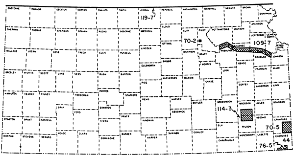
Magnetic, gravity, and seismic methods are used mostly in exploration for oil and gas in Kansas. Seismic exploration has proved to be the most successful of the geophysical tools and, thus, is used almost exclusively by the oil hunter; gravity surveys have had limited success; magnetic work is used little at present. Because geophysical information is obtained only at considerable cost to an individual or company, it is seldom released for public distribution. Thus, it is often difficult to obtain geophysical information other than that published by research institutions (Figure 1).
Figure 1--Index map showing areas in which geophysical work has been conducted by the State Geological Survey of Kansas.
Information on geophysical exploration activity in Kansas was compiled from several sources including National Oil Scouts and Landmen's Association Yearbooks, American Association of Petroleum Geologists annual development issues, Society of Exploration Geophysicists annual review of geophysical activity, and the Kansas Geological Survey annual development reports. Seismic, gravity, and core-drill crew activity is summarized in Table 1 and Figure 2; no data are available for magnetic crew activity.
Table 1--Number of crews operating in Kansas for a ten-year period from 1946-1956.
| Year | Seismic Crews |
Gravimeter Crews |
Core-Drill Crews |
Total Crews |
Total Crew-Weeks all Geophysical |
|---|---|---|---|---|---|
| 1956 | 25 | 1 | 2 | 28 | 547 |
| 1955 | 39 | 1 | 3 | 43 | 740 |
| 1954 | 28 | 1 | 3 | 32 | 729 |
| 1953 | 25 | 1 | 4 | 30 | |
| 1952 | 27 | 1 | 3 | 31 | 967 |
| 1951 | 25 | 1 | 5 | 31 | 792 |
| 1950 | 746 | ||||
| 1949 | 7 | 1 | 4 | 12 | 622 |
| 1948 | 7 | 3 | 9 | 19 | 934 |
| 1947 | 4 | 2 | 5 | 11 | 513 |
| 1946 | 1 | 0 | 7 | 8 | 677 |
Figure 2--Graph of geophysical and core drill activity in terms of crew-weeks from 1937 to 1956.
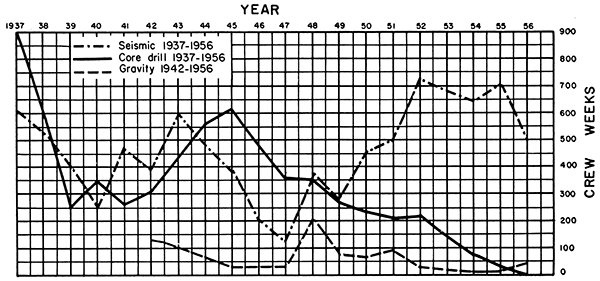
The number of seismic crews in Kansas has increased manyfold since 1946. Although the number of gravimeter and core-drill crews has decreased, the total number of exploration crews has increased because of the increased number of seismic parties.
A graph showing the number of crew-weeks in Kansas from 1937 to 1956 (Fig. 2) corresponds rather well with the economic conditions of the country. In pre-World War II days, exploration was slow but increased rapidly during the war. A postwar slump is evident, especially in 1947 and 1949. The Korean conflict brought about renewed activity, mainly in seismic exploration. Activity in 1956 declined from the preceding four years, possibly reflecting increasing interest in foreign exploration and tight credit.
Seismic exploration has been mainly in the western part of the state, centering in areas of the Central Kansas uplift, Pratt anticline, Sedgwick basin, and Hugoton embayment. Some work also has been reported in the vicinity of the Cambridge arch and along the Nemaha anticline, and in the Salina, Forest City, and Cherokee basins. In 1956, Cowley County reported the most seismic activity; other counties in which exploration took place include Ness, Sherman, Wichita, Pawnee, Morris, Pratt, and Wabaunsee. Gravity work in 1956 was centered in the northwestern part of the state in Decatur, Thomas, Sheridan, Logan, Cheyenne, Sherman, and Rawlins Counties. Core-drill activity in 1956 was confined to Sumner and Cowley Counties.
Since seismic methods were first introduced in Kansas in the late 1920's, a considerable part of the state has been explored in detail for areas favorable for the occurrence of petroleum. If present trends in seismic exploration continue, it appears that the subsurface will be scrutinized even more closely in Kansas. However, refinement in instrumentation and interpretation probably will accomplish this rather than a high level of crew-month activity.
Beebe, B. W., and Ballou, A. L., Jr. (1956) Case history of the Smallwood pool, Stafford County, Kansas: Geophys. Case Histories, v. 2, p. 310-327.
Cook, K. L. (1951) Regional gravity survey in northeastern Oklahoma and southeastern Kansas (abstract): Geophysics, v . 16, no. 3, p. 559-560.
Cook, K. L. (1954) Resistivity surveys over slump structures, Tri-State lead-zinc mining district, Cherokee County, Kansas: Program, Soc, Exp. Geophysicists 24th Ann, Meeting, St. Louis, p. 57.
Cook, K. L. (1955) Magnetic surveys over serpentine masses, Riley County, Kansas: Mining Engineering, v, 7, no. 5, p. 481-488.
Cook, K. L. (1956) Regional gravity survey in northeastern Oklahoma and southeastern Kansas: Geophysics, v. 21, no. 1, p. 88-106.
Cook, K. L., and Van Nostrand, R. G. (1954) Interpretation of resistivity data over filled sinks: Geophysics, v. 19, no. 4, p. 761-790.
Deel, S, A., and Howe, H. H. (1948) United States magnetic tables and magnetic charts for 1945: U. S. Coast and Geodetic Survey, ser. 667, p. 1-135.
Dreyer, R. M. (1947) Magnetic survey of the Bala intrusive, Riley County, Kansas: Kansas Geol. Survey Bull. 70, pt. 2, p. 21-28. [available online]
Dreyer, R. M. (1947a) Magnetic survey of southeastern Crawford County, Kansas: Kansas Geol. Survey Bull. 70, pt. 5, p. 105-115. [available online]
Dreyer, R. M. (1948) Radioactivity surveys in the Kansas part of the Tri-State zinc and lead mining district, Cherokee County, Kansas: Kansas Geol. Survey Bull. 76, pt. 5, p. 113-120.
Duerksen, J. A. (1949) Pendulum gravity data in the United States: U. S. Coast and Geodetic Survey, Spec, Publ. No. 244, p. 1-218,
Faust, L. Y. (1942) Geophysics in the Mid-Continent: Geophysics, v. 7, no. 3, p. 272-274.
Gaither, V. U. (1956) Index of wells shot for velocity (fourth supplement): Geophysics, v. 21, no. 1, p. 156-178.
George, P. W. (1929) Experiments with Eötvös torsion balance in the TriState zinc and lead district: A.I.M.E., Geophysical Prospecting Vol., p. 561-571.
Glover, R. H. (1953) Seismograph pays off in Kansas: World Oil, v. 137, no. 4, p. 109-110, 112, 114, 116.
Hambleton, W, W., and Merriam, D. F. (1955) Magnetic anomalies in Wilson and Woodson Counties, Kansas: Kansas Geol. Survey Bull. 114, pt. 3, p. 113-128. [available online]
Happ, S. C. (1946) Electrical resistivity investigations of levee foundations near Kansas City (abstract): Geol. Soc. America Bull., v. 57, no. 12, pt. 2, p. 1200.
Harbaugh, M. D. (1932) Magnetic map of Tri-State completed: Mining and Metallurgy, v. 13, no. 302, p. 86.
Hartenberger, R. A. (1948) A radioactivity survey over Rose dome, Woodson County, Kansas: Kansas Geol. Survey, open file, p. 1-7.
Heiland, C. A. (1929) Geophysical methods of prospecting: Colorado Sch, Mines Quart" v. 24, no. 1, p. 38, 68-72.
Jakosky, J. J. (1943) Geophysical investigations in the Tri-State zinc and lead mining district by J. J. Jakosky, R. M. Dreyer, and C. H. Wilson (review): Geophysics, v. 8, no. 2, p. 177-178.
Jakosky, J. J. (1943a) Exploration investigations in Tri-State zinc and lead mining district: Am. Assoc. Petroleum Geologists Bull., v. 27, no. 1, p. 86-87.
Jakosky, J. J. (1950) Exploration geophysics, second edition: Trija Publ. Co., Los Angeles, Calif., p. 921-925.
Jakosky, J. J., Dreyer, R. M., and Wilson, C. H. (1942) Geophysical investigations in the Tri-State zinc and lead mining district: Kansas Geol. Survey Bull. 44, p. 1-151. [available online]
Jenny, W. P. (1932) Magnetic vector study of regional and local geologic structure in principal oil states: Am. Assoc. Petroleum Geologists Bull., v. 16, no. 12, p. 1177-1203.
Jenny, W. P. (1941) Geological interpretation of regional magnetic anomalies in central and southern United States: Oil Weekly, v. 103, no. 3, p. 17-18, 22.
Jensen, Homer (1949) Airborne magnetic profile above 40th parallel, eastern Colorado to western Indiana: Geophysics, v. 14, no. 1, p. 57.
Karcher, J. C., and McDermott, Eugene (1935) Deep electrical prospecting: Am. Assoc. Petroleum Geologists Bull., v. 19, no. 1, p. 64-77.
Logue, L. L. (1954) Gravity anomalies of Texas, Oklahoma, and the United States: The Oil and Gas Jour., v. 52, no. 50, p. 132-135.
Lyons, P. L. (1950) A gravity map of the United States: Tulsa Geological Soc. Digest, v. 18, p. 33-43.
Lyons, P. L. (1951) A seismic reflection quality map of the United States: Geophysics, v. 16, no. 3, p. 506-510.
Merriam, D. F. (1954) Electrical resistivity studies in the Kansas River valley: Kansas Geol. Survey Bull. 109, pt. 7, p. 97-112. [available online]
Merriam, D. F., and Hambleton, W. W. (1956) Relation of an airborne magnetic profile to the geology along the Kansas-Nebraska border: Kansas Geol. Survey Bull. 119, pt. 7, p. 251-266. [available online]
Moore, R. W. (1950) Geophysical methods of subsurface exploration applied to the location and evaluation of sand and gravel deposits: Natl. Sand and Gravel Assoc. Circ. 37, p. 1-9.
Moore, R. W. (1952) Geophysical methods of subsurface exploration applied to materials surveys: Highway Research Board Bull. 62, p. 85-107.
Nettleton, L. L. (1943) Transcontinental gravitational and magnetic profile of North America and its relation to structure by G. P. Woollard, (review): Geophysics, v, 8, no. 4, p. 419-421.
Pakiser, L. C., and Mabey, D. R. (1954) Mapping shallow horizons with the reflection seismograph: Science, v. 119, no. 3099, p. 740.
Pakiser, L. C., Mabey, D. R., and Warrick, R. E. (1954) Mapping shallow horizons with reflection seismograph: Am, Assoc. Petroleum Geologists Bull., v. 38, no. 11, p. 2382-2394.
Pakiser, L. C., and Warrick, R. E. (1956) A preliminary evaluation of the shallow reflection seismograph: Geophysics, v. 21, no. 2, p. 388-405.
Patton, J. F. (1935) The shoestring oil sands-their geologic occurrence and the possibilities of tracing them with geophysical methods: Mines Magazine, v. 25, no. 12, p. 17-23.
Stearn, N. H. (1932) Practical geomagnetic exploration with the Hotchkiss superdip: A.I.M.E. Geophysical Prospecting Vol., p. 169-199.
Swan, B. G. (1944) Index of wells shot for velocity: Geophysics, v. 9, no. 4, p. 540-559.
Swan, B. G. (1946) Index of wells shot for velocity: Geophysics, v. 11, no. 4, p. 538-546.
Swan, B. G. (1949) Index of wells shot for velocity (second supplement): Geophysics, v. 14, no. 1, p. 58-66.
Swan, B. G. (1951) Index of wells shot for velocity (third supplement): Geophysics, v. 16, no. 1, p. 140-152.
Thralls, H. M. and Mossman, R. W. (1952) Relations of seismic corrections to surface geology: Geophysics, v. 17, no. 2, p. 218-228.
Trott, M. J. (1939) Geophysical prospecting in Kansas: Mines Magazine, v. 29, no. 6, p. 311-312.
Weatherby, B. B. (1948) Early seismic discoveries in Oklahoma: Geophys. Case Histories, v. 1, p. 283-302.
Westby, G. H. (1947) Geophysics in the Mid-Continent-past results and future application (abstract): The Oil and Gas Jour., v. 45, no. 36, p. 43.
Widess, M, B. (1952) Salt solution, a seismic velocity problem in western Anadarko basin, Kansas-Oklahoma-Texas: Geophysics, v. 17, no. 3, p. 481-504.
Woollard, G. P. (1943) Transcontinental gravitational and magnetic profile of North America and its relation to geologic structure: Geol. Soc. America Bull., v. 54, p. 747-790.
Woollard, G. P. (1948) Recent regional gravity surveys: Am. Geophys. Union Trans., v, 29, no. 5, p. 727-738.
Cook (1954)
Cook and Van Nostrand (1954)
Happ (1946)
Jakosky (1943)
Jakosky, Dreyer, and Wilson (1942)
Karcher and McDermott (1935)
Merriam (1954)
Moore (1950)
Moore (1952)
Patton (1935)
Deel and Howe (1948)
Duerksen (1949)
Faust (1942)
Patton (1935)
Trott (1939)
Westby (1947)
Cook (1951)
Cook (1956)
Duerksen (1949)
George (1929)
Heiland (1929)
Jakosky (1943)
Jakosky, Dreyer, and Wilson (1942)
Logue (1954)
Lyons (1950)
Nettleton (1943)
Westby (1947)
Woollard (1943)
Woollard (1948)
Cook (1955)
Deel and Howe (1948)
Dreyer (1947)
Dreyer (1947a)
Hambleton and Merriam (1955)
Harbaugh (1932)
Heiland (1929)
Jakosky (1943)
Jakosky, Dreyer, and Wilson (1942)
Jenny (1932)
Jenny (1941)
Jensen (1949)
Merriam and Hambleton (1956)
Nettleton (1943)
Patton (1935)
Steam (1932)
Westby (1947)
Woollard (1943)
Beebe and Ballou (1956)
Glover (1953)
Jakosky (1950)
Lyons (1951)
Pakiser and Mabey (1954)
Pakiser, Mabey, and Warrick (1954)
Pakiser and Warrick (1956)
Thralls and Mossman (1952)
Weatherby (1948)
Westby (1947)
Widess (1952)
Dreyer (1948)
Hartenberger (1948)
Jakosky, Dreyer, and Wilson (1942)
Cook (1956)
Cook (1956)
Karcher and McDermott (1935)
Stearn (1932)
Cook (1956)
Gaither (1956)
Swan (1944)
Swan (1946)
Swan (1951)
Swan (1944)
Swan (1946)
Cook (1956)
Jensen (1949)
Merriam and Hambleton (1956)
Swan (1944)
Cook (1954)
Cook (1956)
Cook and Van Nostrand (1954)
Dreyer (1948)
Harbaugh (1932)
Jakosky, Dreyer, and Wilson (1942)
Jensen (1949)
Merriam and Hambleton (1956)
Swan (1944)
Widess (1952)
Woollard (1943)
Deel and Howe (1948)
Woollard (1943)
Cook (1956)
Duerksen (1949)
Widess (1952)
Deel and Howe (1948)
Swan (1944)
Cook (1956)
Dreyer (1947a)
Duerksen (1949)
Harbaugh (1932)
Deel and Howe (1948)
Jensen (1949)
Merriam and Hambleton (1956)
Swan (1944)
Deel and Howe (1948)
Duerksen (1949)
Jensen (1949)
Merriam and Hambleton (1956)
Cook (1956)
Deel and Howe (1948)
Duerksen (1949)
Merriam (1954)
Woollard (1943)
Swan (1944)
Duerksen (1949)
Gaither (1956)
Jakosky (1950)
Swan (1944)
Duerksen (1949)
Swan (1944)
Deel and Howe (1948)
Duerksen (1949)
Gaither (1956)
Swan (1951)
Deel and Howe (1948)
Widess (1952)
Cook (1956)
Deel and Howe (1948)
Deel and Howe (1948)
Jakosky (1950)
Swan (1951)
Woollard (1943)
Widess (1952)
Deel and Howe (1948)
Swan (1944)
Widess (1952)
Deel and Howe (1948)
Cook (1956)
Deel and Howe (1948)
Swan (1944)
Swan (1951)
Deel and Howe (1948)
Gaither (1956)
Swan (1944)
Duerksen (1949)
Swan (1944)
Swan (1951)
Cook (1956)
Duerksen (1949)
Merriam (1954)
Jensen (1949)
Merriam and Hambleton (1956)
Cook (1956)
Duerksen (1949)
Woollard (1943)
Swan (1944)
Widess (1952)
Deel and Howe (1948)
Gaither (1956)
Swan (1944)
Deel and Howe (1948)
Widess (1952)
Cook (1956)
Cook (1956)
Deel and Howe (1948)
Woollard (1943)
Deel and Howe (1948)
Cook (1956)
Duerksen (1949)
Jakosky (1950)
Swan (1944)
Cook (1956)
Deel and Howe (1948)
Deel and Howe (1948)
Swan (1944)
Deel and Howe (1948)
Jensen (1949)
Merriam and Hambleton (1956)
Swan (1949)
Widess (1952)
Cook (1956)
Swan (1944)
Woollard (1943)
Cook (1956)
Deel and Howe (1948)
Deel and Howe (1948)
Duerksen (1949)
Jensen (1949)
Merriam and Hambleton (1956)
Swan (1951)
Cook (1956)
Duerksen (1949)
Jensen (1949)
Merriam and Hambleton (1956)
Cook (1956)
Duerksen (1949)
Swan (1944)
Woollard (1943)
Deel and Howe (1948)
Swan (1944)
Deel and Howe (1948)
Swan (1944)
Jensen (1949)
Merriam and Hambleton (1956)
Swan (1944)
Duerksen (1949)
Merriam (1954)
Woollard (1943)
Deel and Howe (1948)
Duerksen (1949)
Swan (1944)
Jensen (1949)
Merriam and Hambleton (1956)
Deel and Howe (1948)
Swan (1944)
Jensen (1949)
Merriam and Hambleton (1956)
Pakiser, Mabey, and Warrick (1954)
Pakiser and Warrick (1956)
Swan (1944)
Cook (1955)
Dreyer (1947)
Duerksen (1949)
Woollard (1943)
Deel and Howe (1948)
Woollard (1943)
Deel and Howe (1948)
Swan (1944)
Deel and Howe (1948)
Deel and Howe (1948)
Swan (1944)
Deel and Howe (1948)
Swan (1944)
Cook (1956)
Deel and Howe (1948)
Merriam (1954)
Woollard (1943)
Gaither (1956)
Swan (1944)
Woollard (1943)
Deel and Howe (1948)
Swan (1951)
Woollard (1943)
Jensen (1949)
Merriam and Hambleton (1956)
Beebe and Ballou (1956)
Swan (1944)
Swan (1946)
Karcher and McDermott (1935)
Duerksen (1949)
Swan (1944)
Swan (1951)
Swan (1944)
Woollard (1943)
Gaither (1956)
Swan (1944)
Merriam (1954)
Swan (1951)
Woollard (1943)
Deel and Howe (1948)
Duerksen (1949)
Jensen (1949)
Merriam and Hambleton (1956)
Moore (1950)
Moore (1952)
Deel and Howe (1948)
Cook (1956)
Duerksen (1949)
Hambleton and Merriam (1955)
Cook (1956)
Hambleton and Merriam (1955)
Hartenberger (1948)
Cook (1956)
Happ (1946)
Woollard (1943)
Jenny (1932)
Jenny (1941)
Logue (1954)
Lyons (1950)
Lyons (1951)
Woollard (1948)
Kansas Geological Survey, Review of Geophysical Activity in Kansas
Placed on web April 1, 2015; originally published in Aug. 15, 1957.
Comments to webadmin@kgs.ku.edu
The URL for this page is http://www.kgs.ku.edu/Publications/Bulletins/127_1/index.html