Kansas Geological Survey, Bulletin 119, Part 7, originally published in 1956
Originally published in 1956 as Kansas Geological Survey Bulletin 119, Part 7. This is, in general, the original text as published. The information has not been updated. An Acrobat PDF version (2 MB) is also available; Plate 1 available separately.
An airborne magnetic profile made in 1948 is shown in relation to the stratigraphy and structure along the Kansas-Nebraska state line. Rocks ranging in age from Precambrian to Recent are present, and the magnetic profile crosses several major structural provinces, including the Hugoton embayment, Cambridge arch, Salina basin, Nemaha anticline, and Forest City basin.
Variation in the thickness of post-Precambrian rocks produces regional magnetic values that increase to the east. Near-surface disturbances possibly cause numerous minor magnetic irregularities. In western Kansas, the magnetic data indicate the position and configuration of the Precambrian basement, whereas in eastern Kansas they seemingly reveal the general distribution of the Precambrian rock types.
In 1948-, an airborne magnetometer traverse was flown by the Aero Service Corporation along the 40th parallel from near Adena, Colorado, to the vicinity of Indianapolis, Indiana, passing over part of northern Kansas (Jensen, 1949). Since that flight, numerous wells have been drilled in the search for oil and gas in this part of Kansas, greatly adding to the store of geologic knowledge. With this additional information, it is now possible to construct a geologic cross section along the Kansas-Nebraska state line showing the stratigraphic and structural relations of the rocks in the subsurface. Comparison of the magnetic profile with the geologic cross section along the flight line should aid interpretation of magnetic investigations in this region.
Along the Kansas-Nebraska state line, rocks are present ranging in age from Precambrian to Recent. The sedimentary rocks occur as a thin veneer over the shallow Precambrian basement complex.
The basement complex of Precambrian age is comprised of igneous and metamorphic rocks. Farquhar (in press) has shown the generalized distribution of Precambrian rock types in Kansas and has described them from petrographic examination of well cuttings. In general, igneous rocks occur on uplifts and metamorphic rocks occur in basins. Granite is by far the most extensive igneous rock encountered by drilling; diabase has been found in a Clay County well. Schist, gneiss, and quartzite are the most common metamorphic rocks. The distribution of Precambrian rock types is incompletely known, except where these rocks occur at relatively shallow depths in areas of extensive oil exploration. A major unconformity occurs at the top of the Precambrian rocks.
The pre-Pennsylvanian rocks overlying the Precambrian surface in Kansas consist mainly of limestone and dolomite, with some shale and sandstone. Rocks of Cambro-Ordovician, Siluro-Devonian, and Mississippian age are present along the line of the cross section. The thickest sections of these rocks occur near the centers of the different basins, where they have been preserved from extensive erosion. Pre-Pennsylvanian rocks are missing from the crest of the uplifts. Unconformities are common and Widespread in this part of the section. A major unconformity occurs between rocks of Mississippian and Pennsylvanian age.
Rocks of Pennsylvanian and Permian age are characterized by a cyclic repetition of marine and nonmarine strata. Thin, but persistent, units can be traced over large areas of the Midcontinent region. Disconformities in this part of the section are numerous and in places are marked by channel sandstones. There is a major unconformity between Paleozoic and Mesozoic rocks.
Rocks of the Mesozoic Era are predominantly marine shale, limestone, and chalk. Widespread nonmarine deposits of sandstone and clay also are present. These rocks increase in thickness to the west and northwest An unconformity between Mesozoic and Tertiary rocks indicates another complete change in geological conditions.
Nonmarine Tertiary rocks, mainly Pliocene in age, occur largely as a mantle of unconsolidated material over older rocks. Relatively thin beds of sand, gravel, silt, and clay of Quaternary age are confined, for the most part, to the present drainage systems, except in northeastern Kansas where glacial deposits are present.
Several major post-Mississippian structures are revealed on the geologic cross section (Plate 1). Because the cross section is generalized, it shows only the regional structure. Minor structures of less than regional magnitude, although present, are not evident. The vertical exaggeration of 225 times emphasizes the structure. A small cross section with a vertical exaggeration of 10 times is shown for comparison. A list of the wells used to construct the cross section is given in Table 1. Information used in constructing the geologic cross section was obtained for the most part from electric logs supplemented by a study of sample logs and logs of the Kansas Sample Log Service. Data on Precambrian rock types encountered by drilling in some of the wells along the line of the cross section were verified by O. C. Farquhar (personal communication).
Table 1--List of wells used in construction of cross section.
| Well | Location | Deepest rocks encountered |
|---|---|---|
| 1. Deep Rock No. 1 Clark | SW SW SW sec. 23, T. 1 5., R. 42 W. | Weathered granite |
| 2. Ohio No. 1 Rose | NE NE NE sec. 35, T. 1 5., R. 40 W. | Arbuckle |
| 3. Brack No. 1 "B" Judy | NW SE NW sec. 26, T. 1 S., R. 39 W. | Granite |
| 4. Ashland No. 1 Kacirek | NE SE SW sec. 8, T. 2 S., R. 36 W. | Mississippian |
| 5. Stanolind No. 4 Strat. | SW NE sec. 20, T. 1 S., R. 34 W. | Arbuckle |
| 6. Musgrove No. 1 Mines | SE SE SW sec. 11, T. 2 S., R. 30 W. | Arbuckle |
| 7. Helmerich & Payne No. 1 Sauvage | NEc NE sec. 3, T. 1 5., R. 27 W. | Granite |
| 8. Empire No. 1 Tansill | NW NE NE Sec. 26, T. 1 S., R. 24 W. | Weathered granite |
| 9. Jones, Shelbourne, & Farmer No. 1 Gramzow | NE NE SW sec. 10, T. 1 S., R. 22 W. | Granite |
| 10. B & R No. 1 Richards | NW NW SW sec. 24, T. 1 S., R. 19 W. | Arbuckle |
| 11. Black Cat No. 1 Bjurstram | SE SE SE sec. 7, T. 1 S." R. 18 W. | Arbuckle |
| 12. Musgrove No. 1 Jackson | SW SW NE sec. 21, T. 1 5., R. 16 W. | Simpson |
| 13. Snowden No. 1 Lull | C SW NW sec. 5, T. 3 S., R. 11 W. | Arbuckle |
| 14. National Assoc. No. 1 Roe | NE NE NE sec. 19, T. 1 S., R. 7 W. | Arbuckle |
| 15. Gulf No. 1 Baker | NW SE SE sec. 1, T. 1 S., R. 2 E. | Granite |
| 16. Davon No. 1 Schaeffer | NW NW SW Sec. 20, T. 1 S., R. 6 E. | Weathered granite |
| 17. Groge No. 1 Suggett? | NW SW NW sec. 34, T. 2 S., R. 8 E. | Granite(?) |
| 18. Texas No. 1 Murdock | SE SE SW sec. 16, T. 2 S., R. 13 E. | Granite |
| 19. Carter No. 1 Strahm | NW SW NW Sec. 13, T. 2 S., R. 14 E. | Granite |
| 20. Davon No. 1 Yost | SE SW NE sec. 33, T. 1 S., R. 16 E. | Viola |
| 21. Curtis et al. No. 1 Fraser | NW NW NW sec. 14, T. 2 S., R. 19 E. | "Hunton" |
| 22. Plymate-Barnholdt No. 1 Elliot | CSL SE SW sec. 31, T. 3 5., R. 20 E. | Arbuckle |
The western part of the Forest City basin is shown at the eastern end of the cross section. The west flank is relatively steep and the east flank is gentle, giving the basin an asymmetrical shape. The trough of the basin (near well no. 20, Plate 1), which lies near and parallel to the Nemaha anticline, is termed the Brownville syncline (see Jewett, 1951, p. 122). Pre-Pennsylvanian strata have been truncated and overstepped by Pennsylvanian sediments along the western side of the basin. The lower Pennsylvanian beds on the eastern side of the Nemaha anticline abut against the Precambrian core. Structure on top of the Lansing group reveals that the Forest City basin is discernible in Pennsylvanian beds.
The Nemaha anticline is a prominent, narrow, uparched feature that extends northeast-southwest across the eastern part of Kansas. This anticline also is asymmetrical and has a steeper east limb.' Over the crest of the anticline (which is near well no. 18, Plate 1), lower Paleozoic strata have been stripped away and Pennsylvanian beds found to lie on the Precambrian core. Structure on top of the Lansing group reveals the uparched nature of the anticline. Normal and reverse faults are believed to be present locally along the east side of the anticline.
The Salina basin is a large downwarped area flanked on the east by the Nemaha anticline and on the west by the Cambridge arch. On both the east and west sides of the basin, pre-Pennsylvanian strata have been truncated and overstepped by Pennsylvanian beds. The axis of the basin in Permo-Pennsylvanian rocks (near well no. 11, Plate 1) is west of the axis shown on the Precambrian surface (near well no. 13, Plate 1). Mesozoic sediments extend over part of the basin. The basin axis, as revealed on top of the Dakota (near well no. 12, Plate 1), is slightly east of the axis as revealed on the Stone Corral formation.
The Cambridge arch, another major uparched structural feature of Kansas, extends northwest-southeast on the same trend and in line with the Central Kansas uplift. The two features are separated by a structural saddle. In Kansas, the arch is not so acute as the Nemaha anticline, but is larger and broader. The lower Paleozoic strata are truncated and overstepped by Pennsylvanian beds on both flanks of the large anticline, and along the crest (near well no. 7, Plate 1) Pennsylvanian beds overlie the Precambrian basement complex. The anticlinal nature of the structure is revealed in Permo-Pennsylvanian strata as well as Mesozoic rocks, but is not evident in Tertiary beds.
Only a small portion of the northern end of the Hugoton embayment is shown along the line of the cross section. The lower Paleozoic strata in this area are thin and have been truncated and overstepped by Pennsylvanian beds. The thickest sedimentary sequence of rocks is shown at the western end of the cross section along the Kansas-Colorado state line.
The Kansas portion of a magnetic profile along the 40th parallel by Jensen (1949) is reproduced in this paper (Plate 1). Jensen describes the procedure in making the airborne magnetic profile as follows:
Ground position was established through the use of a continuous-strip camera, which gave an unbroken record of the path for the whole trip. The path was then reconstructed by establishing position on Geological Survey quadrangle sheets over those areas covered by the sheets and by correlation with other map sources at the western end of the run where quadrangle sheets were not available.
The altitude over a considerable part of the run was in excess of the scale of the recording radio-altimeter in the aircraft, so the altitude was established by subtracting the mean local ground height from the barometric altimeter record as corrected locally.
No correction is made for a diurnal variation nor for instrumental drift; but it was established at the end of the flight that the total instrument drift had been less than 50 gammas.
The frequency-response characteristics and the noise level of the record are such that the magnetic trace can be accepted as valid within the limits of the line width on the published curve. The datum level is arbitrary and is chosen merely for convenience. The survey was conducted in a manner to insure precise recording of the local variations in total magnetic intensity, rather than to establish exactly the relative values at the opposite ends of the traverse.
In this record, as in all high-sensitivity airborne-magnetometer records, the scalar value of total magnetic intensity, rather than any particular projection of the magnetic vector, is measured. Essentially, each local variation can be taken as the projection of the local anomalous vector upon the total-field vector.
Jensen also states that this flight of more than 900 miles is within the limits of routine airborne magnetic operations.
Little has been published on magnetic investigations in Kansas, although much work has been done by private companies. Heiland (1929) mentioned lateral shift of magnetic axes with reference to structural axes; along the Nemaha anticline irregular polarities have been observed. He suggested that some anomalies probably are caused by changes in lithology of the basement rock. Jenny (1932) in a preliminary study found that eastern Kansas structural lows coincide with magnetic lows and structural highs with magnetic highs. He further concluded that the axis of the granite mass of the Nemaha anticline was west of the structural axis, thus shifting the magnetic axis. Also, Jenny (1941) suggested that many magnetic anomalies in areas of thick sedimentary sections, as in the Forest City basin, are due to regional thickening of sedimentary beds. Jakosky, Dreyer, and Wilson (1943) demonstrated that magnetic surveys were successful in showing regional geologic aspects of the Tri-State area in southeastern Kansas. Woollard (1943) conducted a transcontinental magnetic survey that crossed Kansas near the 39th parallel just south of the airborne magnetic survey reproduced here. He concluded that in western Kansas anomalies may be related to basement configuration. Concerning the Nemaha anticline, he believed that no magnetic pattern definitely can be correlated with structure; the anomalies are related to changes in basement lithology and not to basement configuration. Dreyer (1947), as a result of a magnetic survey, found the Bala intrusive in Riley County to be a vertical, eastward plunging dike. A magnetic low was revealed in the center of the positive anomaly. Dreyer (1947a) also conducted a survey in Crawford County and found that magnetic lows correspond with structural highs. He suggested that this phenomenon may be due to thinning of Pennsylvanian rocks over basement highs or negative polarity of the basement. Cook (1955) surveyed the other intrusives of Riley County and concluded from their magnetic characteristics that they are nearly vertical-cylindrical or vertical-prismatic bodies that plunge to the southeast. Hambleton and Merriam (1955) conducted a magnetic survey in Wilson and Woodson Counties and found magnetic lows over structural highs as Dreyer did in Crawford County. However, igneous intrusives in this area could not be mapped accurately owing to lack of contrast in the magnetic susceptibility of igneous and sedimentary rocks.
According to Jakosky (1950, p. 161), the magnetic susceptibility of rocks usually is directly proportional to their content of ferromagnetic minerals, which include magnetite, ilmenite, pyrrhotite, and franklinite. Of these minerals, magnetite is the most magnetic; only magnetite and ilmenite are known to occur in measurable quantities in Kansas rocks. Stearn (1929, p. 330) has indicated the average sedimentary rock contains a magnetite-ilmenite content of 0.09 percent, the average granite 2.03 percent, and the average basalt 6.53 percent. It is obvious from these data that sedimentary rocks have the least magnetic susceptibility; dark-colored igneous rocks have the greatest magnetic susceptibility. However, this does not mean that sedimentary rocks cannot have a high content of ferromagnetic minerals or, for other reasons, have a greater susceptibility than igneous rocks. It is possible also for a granite to have a larger percentage of ferromagnetic minerals and thus a higher susceptibility than a basalt.
Very little is known regarding the magnetite content of rocks in Kansas. None of the granites of Precambrian age studied by O. C. Farquhar (personal communication) contained more than 2 percent magnetite; the average magnetite content was 0.5 percent. The magnetite content of other Precambrian rock types is not known, but the Precambrian diabase encountered in Clay County, west of the Nemaha ridge, contained about 2 percent magnetite.
The pre-Pennsylvanian Paleozoic rocks, which are mainly limestone, dolomite, shale, and sandstone, probably have low susceptibility. No information is available on the magnetite content of any of these units.
The Permo-Pennsylvanian rocks, especially the sandstones, locally have a high magnetite content. Paul C. Franks (personal communication) reports a magnetite content as high as 8 percent for the Ireland sandstone in the Douglas group (Pennsylvanian) in Wilson and Woodson Counties. The sandstones in the Cherokee group (Pennsylvanian) also have a high magnetite content (Dreyer, 1947a, p. 109). Some of the Permo-Pennsylvanian limestones may have an iron content (Fe2O3) as high as 7 percent, but this is exceptional (Runnels and Schleicher, 1956). On the whole, however, the magnetic susceptibility of Permo-Pennsylvanian rocks probably is low, and iron content may be no indication of magnetic susceptibility.
The Cretaceous rocks likewise, with the exception of some of the sandstones in the Dakota formation, probably have low magnetic susceptibility. Some goethite and siderite are present in the Dakota, and chemical analyses indicate some of the sandstones have an iron oxide content of almost 9 percent (Swineford, 1947, p. 74).
No information is available on the magnetite content of Tertiary rocks, but it is, no doubt, relatively small. However, SWineford observes (personal 'communication) that the magnetite content of Ogallala sands is much greater than the magnetite content of Permian and Cretaceous sandstones. Bowdish and Runnels (1952, p. 293) report that a magnetic concentrate from Kansas River sand near Kansas City is only 0.5 percent by weight of the total sample. There are undoubtedly other areas in the present river channels where the magnetic concentrate will be larger than 0.5 percent.
The intrusive granite at Rose Dome and the intrusive peridotite at Silver City, both in Woodson County, have an average magnetite content of less than 2 percent (Hambleton and Merriam, 1955, p. 127). Some magnetite occurs in the Bala peridotitic intrusive in Riley County (Dreyer, 1947, p. 27). The magnetite content of the other four peridotitic intrusives in Riley County is not known.
Although the geologic cross section is generalized, within limits it portrays accurately the regional thickening and thinning of the sedimentary rocks. Also, the position and configuration of the Precambrian basement, as well as the structure of the overlying beds, are represented. Lacking are accurate data on the magnetic susceptibility of rocks along the line of the geologic cross section and detailed knowledge of the distribution of the different Precambrian rock types. It would be advantageous to have a gravity profile along the line of the cross section to aid in deciphering the magnetic profile.
Several explanations may be offered for the relation of magnetic anomalies to geology in Kansas. (1) The magnetic anomalies may be related to thickening and thinning of sedimentary rocks. The assumption is that the sedimentary rocks of the area have greater influence on the total magnetic field than the underlying Precambrian crystalline rocks. The variations in thickness could be due either to depositional causes or to erosional beveling after deposition. (2) The magnetic anomalies possibly are related to the configuration of the Precambrian basement complex. Where the Precambrian surface is now structurally or topographically high, there would be a corresponding magnetic high; where the surface is structurally or topographically low, the result would be a magnetic low. This condition would be possible only if the overlying rocks have little or no effect on the total magnetic field. (3) An inverse polarity or residual magnetism of the basement rock has been postulated to explain negative values or lows over structural highs. In this case, where basement rock is near enough to the surface to overcome the magnetic effects of the overlying sedimentary rocks, negative readings would be recorded because of the inverse polarity of near-surface crystalline rocks. (4) The distribution of Precambrian rock types possibly may be the dominant influence in the magnetic field, the overlying post-Precambrian rocks having little or no effect. If the granites, basic igneous rocks, and metamorphic sediments contrast sharply in magnetic susceptibility, the resulting map would show only the approximate lithologic boundaries of the different rock types of the Precambrian basement. (5) Near-surface concentrations of magnetic material with high susceptibility may exert a dominant influence, thus serving to mask the underlying effects. Hence, magnetic values would be meaningless in interpreting the structure of the region. (6) Combinations of the above-mentioned conditions are possible for different areas in Kansas.
Of the five different explanations for magnetic anomalies in Kansas, only three can be evaluated to any extent. These are (1) variations in thickness of sedimentary rocks, (2) configuration of the Precambrian surface, and (4) distribution of Precambrian rock types. The other two, (3) inverse polarity of the Precambrian basement complex and (5) near-surface effects, cannot be evaluated properly because of lack of necessary information.
Figure 1 was prepared to help determine the effect of variations in thickness of the sedimentary sequence on the magnetic profile. This figure shows the magnetic profile in relation to (A) thickness of Tertiary rocks, (B) thickness of Mesozoic rocks, (C) thickness of Permo-Pennsylvanian rocks, (D) thickness of prePennsylvanian-post-Precambrian rocks, and (E) total thickness of sedimentary rocks.
Figure 1--Magnetic profile in relation to (A) thickness of Tertiary rocks, (B) thickness of Mesozoic rocks, (C) thickness of Permo-Pennsylvanian rocks, (D) thickness of pre-Pennsylvanian-post-Precambrian rocks, and (E) total thickness of sedimentary rocks.
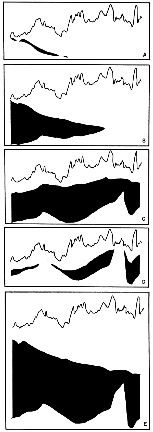
The variation in thickness of Tertiary rocks (Figure 1A) has no obvious effect on the magnetic profile. This is not surprising because the magnetic susceptibility of these rocks probably is low, and too, the total thickness of beds of this age is small. The thickness of Mesozoic rocks (Figure 1B), on the other hand, seemingly influences the magnetic profile. It will be noted that the magnetic values increase to the east and that Mesozoic beds thin to the east. If Mesozoic beds partly mask the magnetic effect of older beds, then the over-all magnetic field would increase in magnitude as Mesozoic rocks thin. This would result in the gradient of the magnetic profile rising to the east.
This same effect is apparent with the general thinning of the Permo-Pennsylvanian beds to the east (Figure 1C) as far as the Nemaha anticline. However, pre-Pennsylvanian beds (Figure 1D) seemingly have little effect on the profile. This might be expected owing to toe low magnetic susceptibility of these strata. Again, the total sedimentary rock sequence (Figure 1E) shows general thinning to the east and a corresponding general rise in gradient of the magnetic profile. Thus, as the thickness of the overlying sedimentary rocks decreases, the magnetic effects of the Precambrian basement become more evident on the profile.
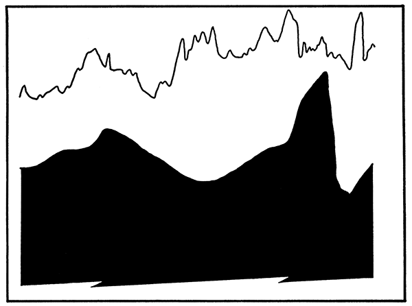
Figure 2 shows the configuration of the Precambrian basement and reveals that in the western part of the state there is general agreement between this surface and the magnetic profile. The structurally low northern end of the Hugoton embayment is shown by a magnetic low and the structurally high Cambridge arch is magnetically high. East of the Cambridge arch on the western flank of the Salina basin this agreement between the Precambrian surface and the magnetic profile is no longer evident .. Likewise, in eastern Kansas, there is little apparent agreement of basement configuration and magnetic profile. The structurally high Nemaha anticline does not show as a pronounced magnetic high, but on the contrary, is magnetically lower than the surrounding area.
Figure 2--Configuration of Precambrian basement.
Many comments may be found in the literature regarding magnetic anomalies associated with the Nemaha anticline. Jenny (1932) suggested that the Nemaha is actually a magnetic high, but that the magnetic axis is west of the structural axis. He later (1941) concluded that the Nemaha was a positive magnetic trend, but did not elaborate. Heiland (1929) noted that on the Nemaha irregular polarities had been observed on local highs and that the El Dorado oil field, which is on a structural high, is a magnetic low. Jakosky (1950) states that because the Precambrian granite on the Nemaha anticline is sufficiently close to the surface, it is positive. Woollard (1943) found no particular correlation of magnetic anomaly and structure.
All wells along the line of the cross section that were drilled into Precambrian encountered only granite or weathered granite (Table 1). However, additional information concerning distribution of Precambrian rock types can be obtained from Farquhar (in press). He shows that granite is present in northern Kansas, except in areas underlying the Salina basin, between parallels 97° and 99°, and in the Forest City basin, between 95° and 96°. The basement complex in these two areas, according to Farquhar, is metamorphic rock consisting of schist, phyllite, non-granitic gneiss, and crystalline limestone. Diabasic igneous rock, encountered in Clay County, is believed to extend northeastward as a narrow band into Nebraska and may intersect the cross section between wells no. 15 and 17 (Plate 1). This diabase probably has a high magnetic susceptibility in comparison to the other rocks., The susceptibility of the metamorphic rocks is probably higher than that of the granite.
East of the Cambridge arch, distribution of Precambrian rock types seemingly influences the magnetic profile to a considerable extent. Suggestion, therefore, is made that: (1) The local positive magnetic anomalies over the Salina basin and the Forest City basin are due mainly to the presence of metamorphic rocks of high magnetic susceptibility. (2) The pronounced positive anomaly directly west of the Nemaha anticline is produced by diabasic igneous rock. (3) The Nemaha anticline is magnetically low relative to the adjacent basins because the granite has a lower magnetic susceptibility than the metamorphic or diabasic rocks. However, superimposed on this low is a small positive anomaly caused by the nearness of the granite to the surface. Also, it may be noted that although magnetic values are relatively low over the Nemaha anticline, they are higher than magnetic values over the Cambridge arch. (4) Many of the minor irregularities that occur on the magnetic profile are due to local near-surface effects.
Because general thinning to the east of the sedimentary rock sequence, especially Mesozoic and Permo-Pennsylvanian rocks, produces a regional magnetic gradient, the .magnetic values are higher in eastern than in western Kansas. In western Kansas, magnetic data seemingly indicate the position and configuration of the Precambrian surface. The Hugoton embayment and the Cambridge arch are delineated, and magnetic highs correspond, in general, to structural highs; whereas magnetic lows correspond to structural lows. In eastern Kansas, magnetic data may reflect distribution of the Precambrian rock types and seemingly bear little relation to the structure of the post-Precambrian strata or to the configuration of the Precambrian surface. The Nemaha anticline is reflected as a small positive anomaly. Local, near-surface magnetic disturbances give rise to numerous minor irregularities on the profile.
Bowdish, F. W. and Runnels, R. T. (1952) Experimental production of feldspar and silica from several river sands in Kansas: Kansas Geol. Survey Bull. 96, pt. 6, p. 277-300. [available online]
Cook, Kenneth L. (1955) Magnetic surveys over serpentine masses, Riley County, Kansas: Mining Engineering, vol. 7. no. 5, p. 481-488.
Dreyer, Robert M. (1947) Magnetic survey of the Bala intrusive, Riley County, Kansas: Kansas Geol. Survey Bull. 70, pt. 2, p. 21-28. [available online]
Dreyer, Robert M. (1947a) Magnetic survey of southeastern Crawford County, Kansas: Kansas Geol. Survey Bull. 70, pt. 5, p. 105-115. [available online]
Farquhar, O. C. (in press) The Precambrian rocks of Kansas: Kansas Geol. Survey Bull. [available online]
Hambleton, W. W. and Merriam, D. F. (1955) Magnetic anomalies in Wilson and Woodson Counties, Kansas: Kansas Geol. Survey Bull. 114, pt. 3, p.113-128. [available online]
Heiland, C. A. (1929) Geophysical methods of prospecting: Colo. Sch. of Mines Quar., vol. 24, no. 1, p. 68-72.
Jakosky, J. J. (1950) Exploration geophysics: Trija Publ. Co., Los Angeles, Calif., p. 1-1195.
Jakosky, J. J., Dreyer, R. M., and Wilson, C. H. (1942) Geophysical investigations in the Tri-State zinc and lead mining district: Kansas Geol. Survey Bull. 44, p. 1-151. [available online]
Jenny, W. P. (1932) Magnetic vector study of regional and local geologic structures in principal oil states: Amer. Assoc. of Petroleum Geol. Bull., vol. 16, no. 12, p.1177-1203.
Jenny, W. P. (1941) Regional magnetic anomalies in central and southern United States: The Oil Weekly, vol. 103, no. 3, p. 17, 18, and 22.
Jensen, Homer (1949) Airborne magnetic profile above 40th parallel, eastern Colorado to western Indiana: Geophysics, vol. 14, no. 1, p. 57.
Jewett, John M. (1951) Geologic structures in Kansas: Kansas Geol. Survey Bull. 90, pt. 6, p. 105-172. [available online]
Runnels, R. T. and Schleicher, J. A. (1956) Chemical composition of eastern Kansas limestones: Kansas Geol. Survey Bull. 119, pt. 3, p. 81-103. [available online]
Stearn, Noel H. (1929) A background for the application of geomagnetics to exploration: AIME, Geophysical Prospecting Vol., p. 315-344:
Swineford, Ada (1947) Cemented sandstones of the Dakota and Kiowa formations in Kansas: Kansas Geol. Survey Bull. 70, pt. 4, p. 53-104. [available online]
Woollard, G. P. (1943) Transcontinental gravitational and magnetic profile of North America and its relation to geologic structure: Geol. Soc. of America Bull., vol. 54, p. 747-789.
Kansas Geological Survey, Relation of an Airborne Magnetic Profile to the Geology along the Kansas-Nebraska Border
Placed on web Oct. 21, 2014; originally published in December 1956.
Comments to webadmin@kgs.ku.edu
The URL for this page is http://www.kgs.ku.edu/Publications/Bulletins/119_7/index.html